 Note:
The expiration time in the watch graphic is amended if the watch is
replaced, cancelled or extended.
Note:
Note:
The expiration time in the watch graphic is amended if the watch is
replaced, cancelled or extended.
Note: Click for
Watch Status Reports.
SEL2
URGENT - IMMEDIATE BROADCAST REQUESTED
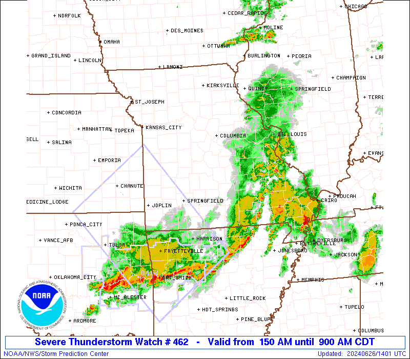
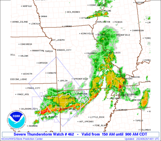
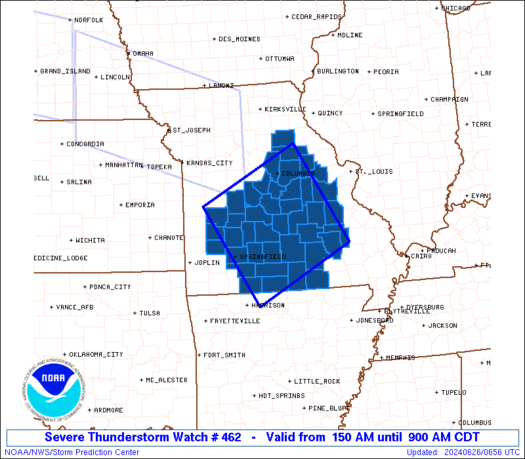
Severe Thunderstorm Watch Number 462
NWS Storm Prediction Center Norman OK
150 AM CDT Wed Jun 26 2024
The NWS Storm Prediction Center has issued a
* Severe Thunderstorm Watch for portions of
Central and southern Missouri
* Effective this Wednesday morning from 150 AM until 900 AM CDT.
* Primary threats include...
Scattered damaging wind gusts to 70 mph possible
Isolated large hail events to 1.5 inches in diameter possible
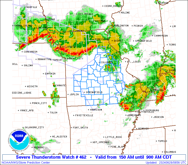
SUMMARY...The first of two substantial convective complexes in the
Missouri Valley region -- now in northern MO -- will affect the
watch area over the next several hours, mainly with potential for
severe gusts on either side of an outflow boundary. The second and
farther one -- now in Nebraska -- will be monitored for a possible
additional watch farther west and later in the morning, as
convective and environmental trends warrant.
The severe thunderstorm watch area is approximately along and 75
statute miles either side of a line from 40 miles west of Columbia
MO to 10 miles east northeast of West Plains MO. For a complete
depiction of the watch see the associated watch outline update
(WOUS64 KWNS WOU2).
PRECAUTIONARY/PREPAREDNESS ACTIONS...
REMEMBER...A Severe Thunderstorm Watch means conditions are
favorable for severe thunderstorms in and close to the watch area.
Persons in these areas should be on the lookout for threatening
weather conditions and listen for later statements and possible
warnings. Severe thunderstorms can and occasionally do produce
tornadoes.
&&
OTHER WATCH INFORMATION...CONTINUE...WW 460...WW 461...
AVIATION...A few severe thunderstorms with hail surface and aloft to
1.5 inches. Extreme turbulence and surface wind gusts to 60 knots. A
few cumulonimbi with maximum tops to 500. Mean storm motion vector
32045.
...Edwards

   SEL2

   URGENT - IMMEDIATE BROADCAST REQUESTED
   Severe Thunderstorm Watch Number 462
   NWS Storm Prediction Center Norman OK
   150 AM CDT Wed Jun 26 2024

   The NWS Storm Prediction Center has issued a

   * Severe Thunderstorm Watch for portions of
     Central and southern Missouri

   * Effective this Wednesday morning from 150 AM until 900 AM CDT.

   * Primary threats include...
     Scattered damaging wind gusts to 70 mph possible
     Isolated large hail events to 1.5 inches in diameter possible

   SUMMARY...The first of two substantial convective complexes in the
   Missouri Valley region -- now in northern MO -- will affect the
   watch area over the next several hours, mainly with potential for
   severe gusts on either side of an outflow boundary.  The second and
   farther one -- now in Nebraska -- will be monitored for a possible
   additional watch farther west and later in the morning, as
   convective and environmental trends warrant.

   The severe thunderstorm watch area is approximately along and 75
   statute miles either side of a line from 40 miles west of Columbia
   MO to 10 miles east northeast of West Plains MO. For a complete
   depiction of the watch see the associated watch outline update
   (WOUS64 KWNS WOU2).

   PRECAUTIONARY/PREPAREDNESS ACTIONS...

   REMEMBER...A Severe Thunderstorm Watch means conditions are
   favorable for severe thunderstorms in and close to the watch area.
   Persons in these areas should be on the lookout for threatening
   weather conditions and listen for later statements and possible
   warnings. Severe thunderstorms can and occasionally do produce
   tornadoes.

   &&

   OTHER WATCH INFORMATION...CONTINUE...WW 460...WW 461...

   AVIATION...A few severe thunderstorms with hail surface and aloft to
   1.5 inches. Extreme turbulence and surface wind gusts to 60 knots. A
   few cumulonimbi with maximum tops to 500. Mean storm motion vector
   32045.

   ...Edwards
 Note:
The Aviation Watch (SAW) product is an approximation to the watch area.
The actual watch is depicted by the shaded areas.
Note:
The Aviation Watch (SAW) product is an approximation to the watch area.
The actual watch is depicted by the shaded areas.
   SAW2
   WW 462 SEVERE TSTM MO 260650Z - 261400Z
   AXIS..75 STATUTE MILES EITHER SIDE OF LINE..
   40W COU/COLUMBIA MO/ - 10ENE UNO/WEST PLAINS MO/
   ..AVIATION COORDS.. 65NM EITHER SIDE /35W COU - 55NW ARG/
   HAIL SURFACE AND ALOFT..1.5 INCHES. WIND GUSTS..60 KNOTS.
   MAX TOPS TO 500. MEAN STORM MOTION VECTOR 32045.

   LAT...LON 39409178 37399056 36219283 38229412

   THIS IS AN APPROXIMATION TO THE WATCH AREA.  FOR A
   COMPLETE DEPICTION OF THE WATCH SEE WOUS64 KWNS
   FOR WOU2.
Watch 462 Status Report Messages:
STATUS REPORT #4 ON WW 462

VALID 261210Z - 261340Z

SEVERE WEATHER THREAT CONTINUES RIGHT OF A LINE FROM 15 ESE SGF
TO 15 SSE TBN TO 30 NW POF.

..MOSIER..06/26/24

ATTN...WFO...LSX...SGF...

&&

STATUS REPORT FOR WS 462

SEVERE WEATHER THREAT CONTINUES FOR THE FOLLOWING AREAS

MOC043-067-091-149-153-203-213-215-229-261340-

MO
.    MISSOURI COUNTIES INCLUDED ARE

CHRISTIAN	     DOUGLAS		 HOWELL
OREGON		     OZARK		 SHANNON
TANEY		     TEXAS		 WRIGHT
$$


THE WATCH STATUS MESSAGE IS FOR GUIDANCE PURPOSES ONLY.  PLEASE
REFER TO WATCH COUNTY NOTIFICATION STATEMENTS FOR OFFICIAL
INFORMATION ON COUNTIES...INDEPENDENT CITIES AND MARINE ZONES
CLEARED FROM SEVERE THUNDERSTORM AND TORNADO WATCHES.
$$

STATUS REPORT #3 ON WW 462

VALID 261030Z - 261140Z

SEVERE WEATHER THREAT CONTINUES RIGHT OF A LINE FROM 20 E SZL TO
10 ENE VIH TO 35 NW POF.

..MOSIER..06/26/24

ATTN...WFO...LSX...SGF...

&&

STATUS REPORT FOR WS 462

SEVERE WEATHER THREAT CONTINUES FOR THE FOLLOWING AREAS

MOC015-029-039-043-057-059-065-067-077-085-091-105-125-131-141-
149-153-161-167-169-185-203-213-215-225-229-261140-

MO
.    MISSOURI COUNTIES INCLUDED ARE

BENTON		     CAMDEN		 CEDAR
CHRISTIAN	     DADE		 DALLAS
DENT		     DOUGLAS		 GREENE
HICKORY 	     HOWELL		 LACLEDE
MARIES		     MILLER		 MORGAN
OREGON		     OZARK		 PHELPS
POLK		     PULASKI		 ST. CLAIR
SHANNON 	     TANEY		 TEXAS
WEBSTER 	     WRIGHT
$$


THE WATCH STATUS MESSAGE IS FOR GUIDANCE PURPOSES ONLY.  PLEASE
REFER TO WATCH COUNTY NOTIFICATION STATEMENTS FOR OFFICIAL
INFORMATION ON COUNTIES...INDEPENDENT CITIES AND MARINE ZONES
CLEARED FROM SEVERE THUNDERSTORM AND TORNADO WATCHES.
$$

STATUS REPORT #2 ON WW 462

VALID 260940Z - 261040Z

SEVERE WEATHER THREAT CONTINUES RIGHT OF A LINE FROM 20 E SZL TO
10 ENE VIH TO 35 NW POF.

..MOSIER..06/26/24

ATTN...WFO...LSX...SGF...

&&

STATUS REPORT FOR WS 462

SEVERE WEATHER THREAT CONTINUES FOR THE FOLLOWING AREAS

MOC015-029-039-043-057-059-065-067-077-085-091-105-125-131-141-
149-153-161-167-169-185-203-213-215-225-229-261040-

MO
.    MISSOURI COUNTIES INCLUDED ARE

BENTON		     CAMDEN		 CEDAR
CHRISTIAN	     DADE		 DALLAS
DENT		     DOUGLAS		 GREENE
HICKORY 	     HOWELL		 LACLEDE
MARIES		     MILLER		 MORGAN
OREGON		     OZARK		 PHELPS
POLK		     PULASKI		 ST. CLAIR
SHANNON 	     TANEY		 TEXAS
WEBSTER 	     WRIGHT
$$


THE WATCH STATUS MESSAGE IS FOR GUIDANCE PURPOSES ONLY.  PLEASE
REFER TO WATCH COUNTY NOTIFICATION STATEMENTS FOR OFFICIAL
INFORMATION ON COUNTIES...INDEPENDENT CITIES AND MARINE ZONES
CLEARED FROM SEVERE THUNDERSTORM AND TORNADO WATCHES.
$$

STATUS REPORT #1 ON WW 462

VALID 260845Z - 260940Z

THE SEVERE WEATHER THREAT CONTINUES ACROSS THE ENTIRE WATCH AREA.

..MOSIER..06/26/24

ATTN...WFO...LSX...SGF...

&&

STATUS REPORT FOR WS 462

SEVERE WEATHER THREAT CONTINUES FOR THE FOLLOWING AREAS

MOC007-015-019-027-029-039-043-051-055-057-059-065-067-071-073-
077-085-091-093-105-125-131-135-137-139-141-149-151-153-161-167-
169-179-185-203-213-215-219-221-225-229-260940-

MO
.    MISSOURI COUNTIES INCLUDED ARE

AUDRAIN 	     BENTON		 BOONE
CALLAWAY	     CAMDEN		 CEDAR
CHRISTIAN	     COLE		 CRAWFORD
DADE		     DALLAS		 DENT
DOUGLAS 	     FRANKLIN		 GASCONADE
GREENE		     HICKORY		 HOWELL
IRON		     LACLEDE		 MARIES
MILLER		     MONITEAU		 MONROE
MONTGOMERY	     MORGAN		 OREGON
OSAGE		     OZARK		 PHELPS
POLK		     PULASKI		 REYNOLDS
ST. CLAIR	     SHANNON		 TANEY
TEXAS		     WARREN		 WASHINGTON
WEBSTER 	     WRIGHT
$$


THE WATCH STATUS MESSAGE IS FOR GUIDANCE PURPOSES ONLY.  PLEASE
REFER TO WATCH COUNTY NOTIFICATION STATEMENTS FOR OFFICIAL
INFORMATION ON COUNTIES...INDEPENDENT CITIES AND MARINE ZONES
CLEARED FROM SEVERE THUNDERSTORM AND TORNADO WATCHES.
$$
Note:
Click for Complete Product Text.
Tornadoes
Probability of 2 or more tornadoes
|
Low (<5%)
|
Probability of 1 or more strong (EF2-EF5) tornadoes
|
Low (<2%)
|
Wind
Probability of 10 or more severe wind events
|
Mod (40%)
|
Probability of 1 or more wind events > 65 knots
|
Low (20%)
|
Hail
Probability of 10 or more severe hail events
|
Low (20%)
|
Probability of 1 or more hailstones > 2 inches
|
Low (10%)
|
Combined Severe Hail/Wind
Probability of 6 or more combined severe hail/wind events
|
Mod (60%)
|
For each watch, probabilities for particular events inside the watch
(listed above in each table) are determined by the issuing forecaster.
The "Low" category contains probability values ranging from less than 2%
to 20% (EF2-EF5 tornadoes), less than 5% to 20% (all other probabilities),
"Moderate" from 30% to 60%, and "High" from 70% to greater than 95%.
High values are bolded and lighter in color to provide awareness of
an increased threat for a particular event.


 @NWSSPC