 Note:
The expiration time in the watch graphic is amended if the watch is
replaced, cancelled or extended.
Note:
Note:
The expiration time in the watch graphic is amended if the watch is
replaced, cancelled or extended.
Note: Click for
Watch Status Reports.
SEL3
URGENT - IMMEDIATE BROADCAST REQUESTED
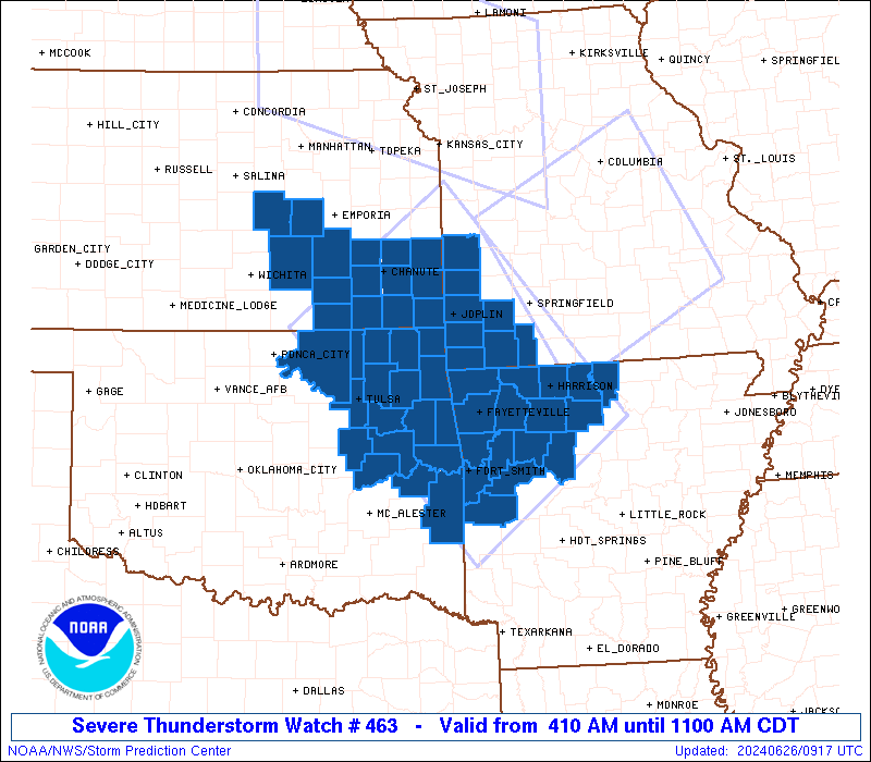
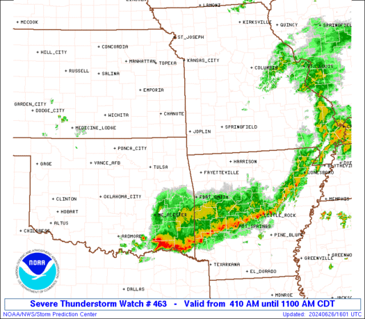
Severe Thunderstorm Watch Number 463
NWS Storm Prediction Center Norman OK
410 AM CDT Wed Jun 26 2024
The NWS Storm Prediction Center has issued a
* Severe Thunderstorm Watch for portions of
Northwestern Arkansas
Southeastern Kansas
Southwestern Missouri
Northeastern Oklahoma
* Effective this Wednesday morning from 410 AM until 1100 AM CDT.
* Primary threats include...
Scattered damaging wind gusts to 70 mph likely
Isolated large hail events to 1.5 inches in diameter possible
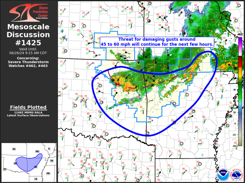
SUMMARY...Merging areas of strong-severe thunderstorms -- already
with a history of severe wind in parts of NE, northeastern KS and
northwestern MO -- should evolve into a new complex and move
southeastward over the 4-state area of the western Ozarks. Activity
may reach the Arkansas River Valley between Tulsa and the Ft. Smith
area while still potentially severe later this morning. Damaging
wind will remain the primary threat, with isolated large hail
possible predominantly ahead of the main complex.
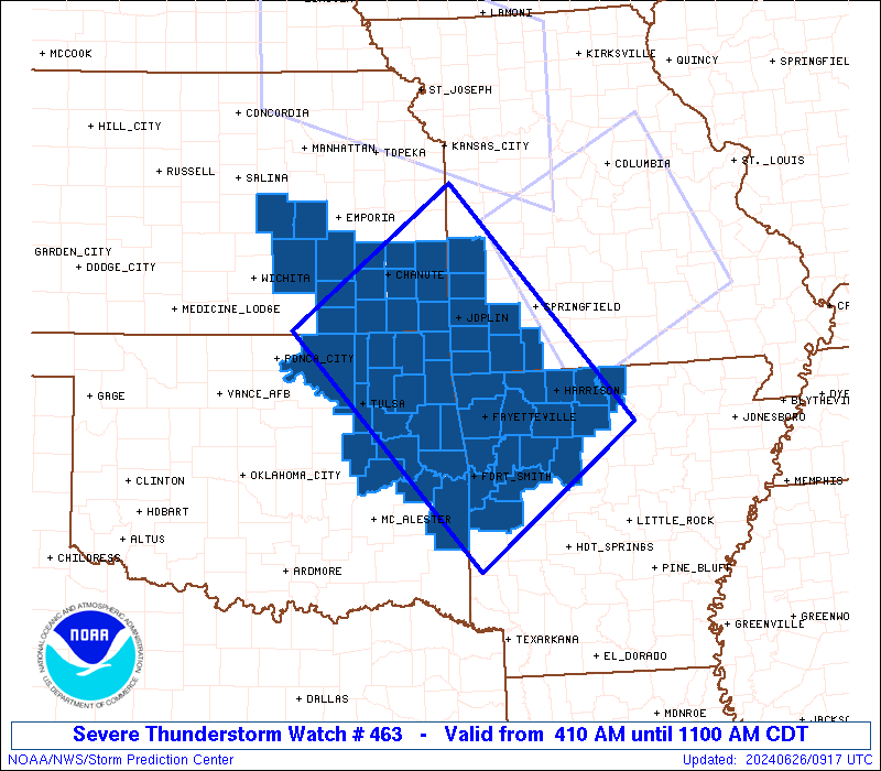
The severe thunderstorm watch area is approximately along and 85
statute miles either side of a line from 20 miles northwest of
Chanute KS to 15 miles south southwest of Russellville AR. For a
complete depiction of the watch see the associated watch outline
update (WOUS64 KWNS WOU3).
PRECAUTIONARY/PREPAREDNESS ACTIONS...
REMEMBER...A Severe Thunderstorm Watch means conditions are
favorable for severe thunderstorms in and close to the watch area.
Persons in these areas should be on the lookout for threatening
weather conditions and listen for later statements and possible
warnings. Severe thunderstorms can and occasionally do produce
tornadoes.
&&
OTHER WATCH INFORMATION...CONTINUE...WW 461...WW 462...
AVIATION...A few severe thunderstorms with hail surface and aloft to
1.5 inches. Extreme turbulence and surface wind gusts to 60 knots. A
few cumulonimbi with maximum tops to 550. Mean storm motion vector
32040.
...Edwards
SEL3
URGENT - IMMEDIATE BROADCAST REQUESTED
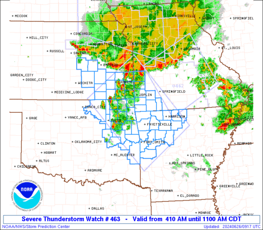
Severe Thunderstorm Watch Number 463
NWS Storm Prediction Center Norman OK
410 AM CDT Wed Jun 26 2024
The NWS Storm Prediction Center has issued a
* Severe Thunderstorm Watch for portions of
Northwestern Arkansas
Southeastern Kansas
Southwestern Missouri
Northeastern Oklahoma
* Effective this Wednesday morning from 410 AM until 1100 AM CDT.
* Primary threats include...
Scattered damaging wind gusts to 70 mph likely
Isolated large hail events to 1.5 inches in diameter possible
SUMMARY...Merging areas of strong-severe thunderstorms -- already
with a history of severe wind in parts of NE, northeastern KS and
northwestern MO -- should evolve into a new complex and move
southeastward over the 4-state area of the western Ozarks. Activity
may reach the Arkansas River Valley between Tulsa and the Ft. Smith
area while still potentially severe later this morning. Damaging
wind will remain the primary threat, with isolated large hail
possible predominantly ahead of the main complex.
The severe thunderstorm watch area is approximately along and 85
statute miles either side of a line from 20 miles northwest of
Chanute KS to 15 miles south southwest of Russellville AR. For a
complete depiction of the watch see the associated watch outline
update (WOUS64 KWNS WOU3).
PRECAUTIONARY/PREPAREDNESS ACTIONS...
REMEMBER...A Severe Thunderstorm Watch means conditions are
favorable for severe thunderstorms in and close to the watch area.
Persons in these areas should be on the lookout for threatening
weather conditions and listen for later statements and possible
warnings. Severe thunderstorms can and occasionally do produce
tornadoes.
&&
OTHER WATCH INFORMATION...CONTINUE...WW 461...WW 462...
AVIATION...A few severe thunderstorms with hail surface and aloft to
1.5 inches. Extreme turbulence and surface wind gusts to 60 knots. A
few cumulonimbi with maximum tops to 550. Mean storm motion vector
32040.
...Edwards
 Note:
The Aviation Watch (SAW) product is an approximation to the watch area.
The actual watch is depicted by the shaded areas.
Note:
The Aviation Watch (SAW) product is an approximation to the watch area.
The actual watch is depicted by the shaded areas.
   SAW3
   WW 463 SEVERE TSTM AR KS MO OK 260910Z - 261600Z
   AXIS..85 STATUTE MILES EITHER SIDE OF LINE..
   20NW CNU/CHANUTE KS/ - 15SSW RUE/RUSSELLVILLE AR/
   ..AVIATION COORDS.. 75NM EITHER SIDE /51NNW OSW - 55WNW LIT/
   HAIL SURFACE AND ALOFT..1.5 INCHES. WIND GUSTS..60 KNOTS.
   MAX TOPS TO 550. MEAN STORM MOTION VECTOR 32040.

   LAT...LON 38689457 35879206 34229430 37059689

   THIS IS AN APPROXIMATION TO THE WATCH AREA.  FOR A
   COMPLETE DEPICTION OF THE WATCH SEE WOUS64 KWNS
   FOR WOU3.
Watch 463 Status Report Messages:
STATUS REPORT #2 ON WW 463

VALID 261215Z - 261340Z

SEVERE WEATHER THREAT CONTINUES RIGHT OF A LINE FROM 35 WSW EMP
TO 15 ESE GMJ TO 30 SE SGF.

..MOSIER..06/26/24

ATTN...WFO...LZK...TSA...ICT...SGF...

&&

STATUS REPORT FOR WS 463

SEVERE WEATHER THREAT CONTINUES FOR THE FOLLOWING AREAS

ARC005-007-009-015-033-047-071-083-087-089-101-115-127-129-131-
143-261340-

AR
.    ARKANSAS COUNTIES INCLUDED ARE

BAXTER		     BENTON		 BOONE
CARROLL 	     CRAWFORD		 FRANKLIN
JOHNSON 	     LOGAN		 MADISON
MARION		     NEWTON		 POPE
SCOTT		     SEARCY		 SEBASTIAN
WASHINGTON
$$


KSC015-019-049-125-261340-

KS
.    KANSAS COUNTIES INCLUDED ARE

BUTLER		     CHAUTAUQUA 	 ELK
MONTGOMERY
$$


MOC209-261340-

MO
.    MISSOURI COUNTIES INCLUDED ARE

STONE
$$


OKC001-021-035-041-061-079-091-097-101-105-111-113-131-135-143-
145-147-261340-

OK
.    OKLAHOMA COUNTIES INCLUDED ARE

ADAIR		     CHEROKEE		 CRAIG
DELAWARE	     HASKELL		 LE FLORE
MCINTOSH	     MAYES		 MUSKOGEE
NOWATA		     OKMULGEE		 OSAGE
ROGERS		     SEQUOYAH		 TULSA
WAGONER 	     WASHINGTON
$$


THE WATCH STATUS MESSAGE IS FOR GUIDANCE PURPOSES ONLY.  PLEASE
REFER TO WATCH COUNTY NOTIFICATION STATEMENTS FOR OFFICIAL
INFORMATION ON COUNTIES...INDEPENDENT CITIES AND MARINE ZONES
CLEARED FROM SEVERE THUNDERSTORM AND TORNADO WATCHES.
$$

STATUS REPORT #1 ON WW 463

VALID 261030Z - 261140Z

THE SEVERE WEATHER THREAT CONTINUES ACROSS THE ENTIRE WATCH AREA.

..MOSIER..06/26/24

ATTN...WFO...LZK...TSA...ICT...SGF...

&&

STATUS REPORT FOR WS 463

SEVERE WEATHER THREAT CONTINUES FOR THE FOLLOWING AREAS

ARC005-007-009-015-033-047-071-083-087-089-101-115-127-129-131-
143-261140-

AR
.    ARKANSAS COUNTIES INCLUDED ARE

BAXTER		     BENTON		 BOONE
CARROLL 	     CRAWFORD		 FRANKLIN
JOHNSON 	     LOGAN		 MADISON
MARION		     NEWTON		 POPE
SCOTT		     SEARCY		 SEBASTIAN
WASHINGTON
$$


KSC001-011-015-017-019-021-037-049-073-099-115-125-133-205-207-
261140-

KS
.    KANSAS COUNTIES INCLUDED ARE

ALLEN		     BOURBON		 BUTLER
CHASE		     CHAUTAUQUA 	 CHEROKEE
CRAWFORD	     ELK		 GREENWOOD
LABETTE 	     MARION		 MONTGOMERY
NEOSHO		     WILSON		 WOODSON
$$


MOC009-011-097-109-119-145-209-217-261140-

MO
.    MISSOURI COUNTIES INCLUDED ARE

BARRY		     BARTON		 JASPER
LAWRENCE	     MCDONALD		 NEWTON
STONE		     VERNON
$$


OKC001-021-035-041-061-079-091-097-101-105-111-113-115-131-135-
143-145-147-261140-

OK
.    OKLAHOMA COUNTIES INCLUDED ARE

ADAIR		     CHEROKEE		 CRAIG
DELAWARE	     HASKELL		 LE FLORE
MCINTOSH	     MAYES		 MUSKOGEE
NOWATA		     OKMULGEE		 OSAGE
OTTAWA		     ROGERS		 SEQUOYAH
TULSA		     WAGONER		 WASHINGTON
$$


THE WATCH STATUS MESSAGE IS FOR GUIDANCE PURPOSES ONLY.  PLEASE
REFER TO WATCH COUNTY NOTIFICATION STATEMENTS FOR OFFICIAL
INFORMATION ON COUNTIES...INDEPENDENT CITIES AND MARINE ZONES
CLEARED FROM SEVERE THUNDERSTORM AND TORNADO WATCHES.
$$
Note:
Click for Complete Product Text.
Tornadoes
Probability of 2 or more tornadoes
|
Low (<5%)
|
Probability of 1 or more strong (EF2-EF5) tornadoes
|
Low (<2%)
|
Wind
Probability of 10 or more severe wind events
|
Mod (60%)
|
Probability of 1 or more wind events > 65 knots
|
Low (20%)
|
Hail
Probability of 10 or more severe hail events
|
Mod (30%)
|
Probability of 1 or more hailstones > 2 inches
|
Low (20%)
|
Combined Severe Hail/Wind
Probability of 6 or more combined severe hail/wind events
|
High (80%)
|
For each watch, probabilities for particular events inside the watch
(listed above in each table) are determined by the issuing forecaster.
The "Low" category contains probability values ranging from less than 2%
to 20% (EF2-EF5 tornadoes), less than 5% to 20% (all other probabilities),
"Moderate" from 30% to 60%, and "High" from 70% to greater than 95%.
High values are bolded and lighter in color to provide awareness of
an increased threat for a particular event.


 @NWSSPC