|
| Mesoscale Discussion 1644 |
|
< Previous MD Next MD >
|
|
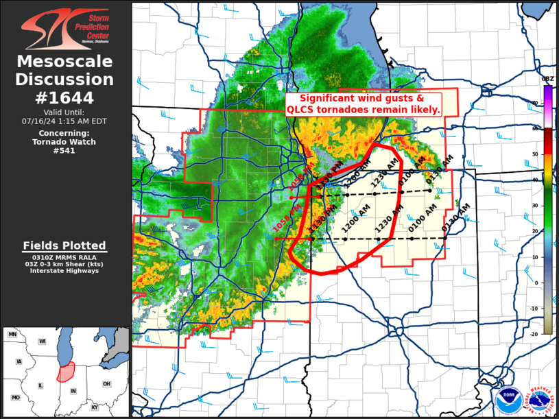
   Mesoscale Discussion 1644
   NWS Storm Prediction Center Norman OK
   1013 PM CDT Mon Jul 15 2024

   Areas affected...Northwest Indiana into far southwest lower Michigan

   Concerning...Tornado Watch 541...

   Valid 160313Z - 160515Z

   The severe weather threat for Tornado Watch 541 continues.

   SUMMARY...Conditions remain favorable for significant (75+ mph) wind
   gusts and QLCS tornadoes as a MCS moves into northwest Indiana and
   far southwest lower Michigan.

   DISCUSSION...Over the past 30 minutes, multiple QLCS tornadoes have
   been noted in velocity/correlation coefficient data from radars out
   of the Chicago, IL area. Additionally, a measured wind gust of 75
   mph was reported at the O'Hare airport, and the KLOT VWP observed 60
   knot winds within the lowest kilometer associated with the passage
   of the gust front. GOES IR imagery suggests that this portion of the
   MCS is currently the strongest with multiple deep convective
   updrafts embedded within the leading edge of the line. A buoyant air
   mass remains in place downstream across northwest IN and far
   southwest MI, and while low-level shear is currently not overly
   strong downstream, winds in the lowest few kilometers are expected
   to increase ahead of the MCS due to the deepening MCV currently
   moving over lower Lake Michigan (such as trend was noted in the KLOT
   VWP prior to MCS passage, and a similar trend is currently being
   noted in the KIWX VWP). Consequently, the threat for significant
   wind gusts and QLCS tornadoes should persist for the next couple of
   hours.

   ..Moore.. 07/16/2024

   ...Please see www.spc.noaa.gov for graphic product...

   ATTN...WFO...IWX...IND...LOT...

   LAT...LON   40928622 40648670 40518703 40478736 40528761 40658784
               40758788 40968770 41328759 41568756 41688728 41848669
               42098649 42028617 41878603 41378607 40928622
|
|
Top/All Mesoscale Discussions/Forecast Products/Home
|
|


 @NWSSPC