|
| Mesoscale Discussion 2213 |
|
< Previous MD Next MD >
|
|
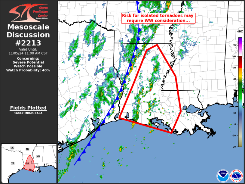
   Mesoscale Discussion 2213
   NWS Storm Prediction Center Norman OK
   1006 AM CST Tue Nov 05 2024

   Areas affected...much of Louisiana and into southwestern Mississippi

   Concerning...Severe potential...Watch possible

   Valid 051606Z - 051700Z

   Probability of Watch Issuance...40 percent

   SUMMARY...Occasionally rotating storms are expected over the next
   few hours across parts of Louisiana and adjacent southwestern
   Mississippi, ahead of the advancing cold front.  Current indications
   are that WW issuance will remain unnecessary.

   DISCUSSION...Latest observational data shows a cold front advancing
   across western Louisiana and far southeastern Texas at this time,
   with a band of generally weak convection along and behind the
   boundary.  Meanwhile, with a very moist warm-sector boundary layer
   contributing to 500 to 1000 J/kg mixed-layer CAPE per RAP-based
   objective analysis, widely scattered pre-frontal storms have
   evolved, with a couple of the longer-lived updrafts exhibiting
   low-level rotation.

   Thus far, intensity of the updrafts and strength of rotation has
   remained somewhat limited generally -- suggesting only weak/brief
   tornado potential; a recent tornado has been reported but with a
   storm that is exhibiting only limited low-level rotation suggestive
   of limited tornado intensity.  Given observed winds veering
   gradually with height but only moderate in magnitude, the
   current/limited degree of updraft rotation should be maintained.
   With that said, we will continue to monitor convective evolution
   over the next couple of hours, as an increase in coverage of the
   stronger updrafts could require closer examination of potential for
   WW issuance.

   ..Goss/Hart.. 11/05/2024

   ...Please see www.spc.noaa.gov for graphic product...

   ATTN...WFO...JAN...LIX...LCH...SHV...

   LAT...LON   29829370 31299302 32729238 32969185 31619093 30109069
               29189116 29829370
|
|
Top/All Mesoscale Discussions/Forecast Products/Home
|
|


 @NWSSPC