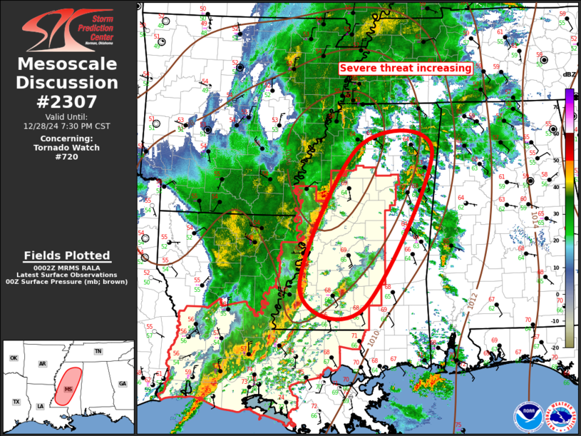
   Mesoscale Discussion 2307
   NWS Storm Prediction Center Norman OK
   0604 PM CST Sat Dec 28 2024

   Areas affected...Central/northern Mississippi

   Concerning...Tornado Watch 720...

   Valid 290004Z - 290130Z

   The severe weather threat for Tornado Watch 720 continues.

   SUMMARY...Severe threat will increase across central into northern
   Mississippi over the next several hours. Tornadoes and damaging
   winds are the primary risks. Tornado watch will be expanded east,
   and north.

   DISCUSSION...LLJ is expected to increase markedly across MS into
   middle TN later this evening. Latest guidance suggests 850mb flow
   should increase in excess of 60kt which will encourage continued
   boundary-layer recovery into this portion of the mid-south region.
   Latest VWP data from GWX supports this with 0-3km SRH greater than
   700 m2/s2, and 2km flow around 55kt. Over the last hour or so,
   pre-squall line convection has gradually increased in intensity, and
   a maturing supercell, potentially tornadic, is tracking across
   Lincoln into Lawrence County MS. As the air mass recovers, and
   buoyancy increases, these types of structures may increase ahead of
   the surging squall line. Strong large-scale forcing will overspread,
   and support, the squall line such that it should remain the primary
   storm mode this evening. Even so, pre-squall line, and embedded,
   supercells are expected. Tornado threat remains highest with these
   supercells.

   Tornado watch will need to be expanded east ahead of this surging
   activity.

   ..Darrow.. 12/29/2024

   ...Please see www.spc.noaa.gov for graphic product...

   ATTN...WFO...MEG...JAN...

   LAT...LON   31729109 34228987 34148830 31378975 31729109
|


 @NWSSPC