SPC AC 190534
Day 2 Convective Outlook
NWS Storm Prediction Center Norman OK
1234 AM CDT Sat Apr 19 2025
Valid 201200Z - 211200Z
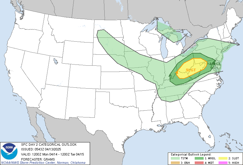
...THERE IS AN ENHANCED RISK OF SEVERE THUNDERSTORMS FROM NORTHWEST
ARKANSAS INTO CENTRAL MISSOURI AND FAR WEST-CENTRAL ILLINOIS...
...SUMMARY...
Severe thunderstorms are expected on Sunday from east Texas into the
lower Missouri and middle Mississippi Valleys. The greatest damaging
wind and tornado potential will be over portions of northern
Arkansas into Missouri and far west-central Illinois.
...Eastern OK/ArkLaTex into the Mid-MS Valley...
A compact upper shortwave trough located over the southern High
Plains Sunday morning will lift northeast through the period,
becoming oriented over the Mid/Upper MS Valley/Upper Great Lakes
vicinity by Monday morning. A belt of intense south/southwest
deep-layer flow associated with this feature will overspread
portions of the eastern OK into the Ozarks and Mid-MS Valley, with a
500 mb jet streak around 70-90 kt over the Lower MO Valley around
21-00z.
At the surface, low pressure over OK at the beginning of the period
will lift north/northeast over the Lower MO Valley by 00z, and into
southern WI by 12z Monday. A cold front will sweep east across the
region as this occurs, while a warm front lifts northward across
MO/IL. Southerly low-level flow will transport modest boundary-layer
moisture northward across the Ozarks/Mid-MS Valley, with mainly low
60s F dewpoints forecast. Mid-60s F dewpoints are more likely from
eastern OK/AR southward.
Some uncertainty still remains regarding the degree of
destabilization across the region. Cloud cover and areas of
precipitation during the morning hours could limit stronger
destabilization, as well as prevent steepening of low-level lapse
rates. Nevertheless, deep-layer flow will be quite strong during the
day and into the evening (decreasing with southward extent toward
east TX/northern LA). Forecast soundings indicate supercell wind
profiles, and initial supercells may be possible ahead of the
eastward-advancing cold front. Convection may tend to grow upscale
into one or more line segments given linear forcing along the cold
front. Nevertheless, tornadoes will be possible with either storm
mode given backed low-level winds contributing to enlarged, looping
low-level hodographs, and a strong low-level jet supporting 0-1 km
SRH greater than 250 m2/s2. Swaths of damaging gusts also will be
possible, especially as convection becomes organized into an
eastward progressing line.
..Leitman.. 04/19/2025
CLICK TO GET WUUS02 PTSDY2 PRODUCT
NOTE: THE NEXT DAY 2 OUTLOOK IS SCHEDULED BY 1730Z
CURRENT UTC TIME: 2323Z (11:23PM), RELOAD THIS PAGE TO UPDATE THE TIME
|


 @NWSSPC