Note:
The expiration time in the watch graphic is amended if the watch is
replaced, cancelled or extended.
Note:
Note:
The expiration time in the watch graphic is amended if the watch is
replaced, cancelled or extended.
Note: Click for
Watch Status Reports.
SEL3
URGENT - IMMEDIATE BROADCAST REQUESTED
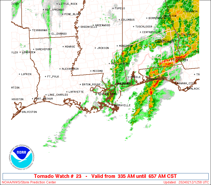
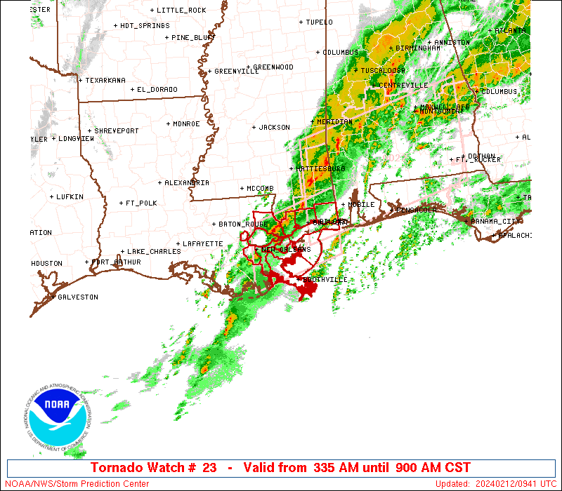
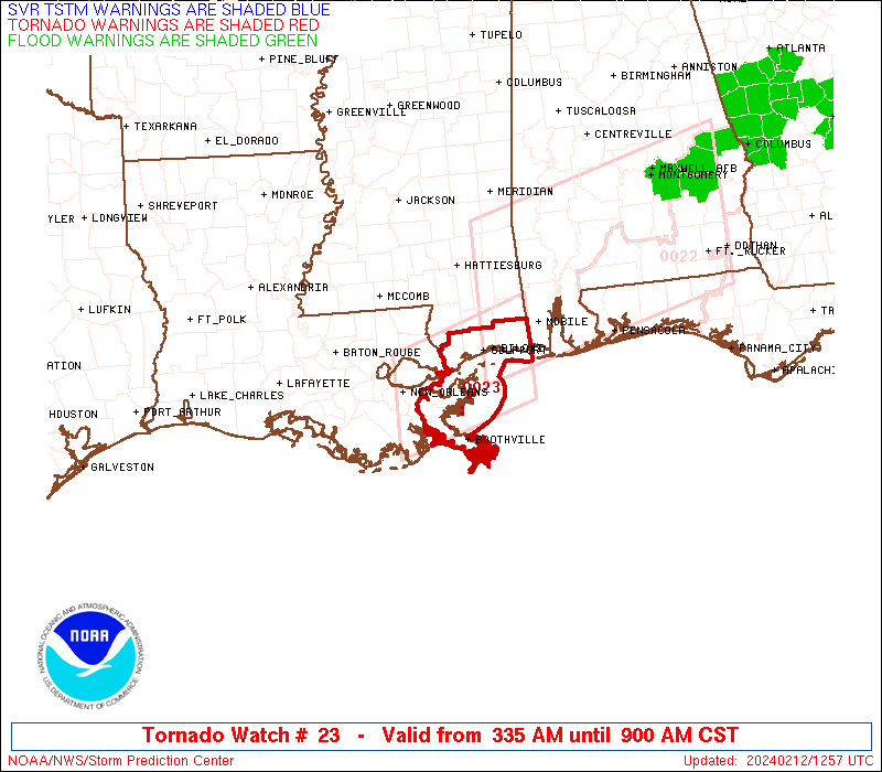
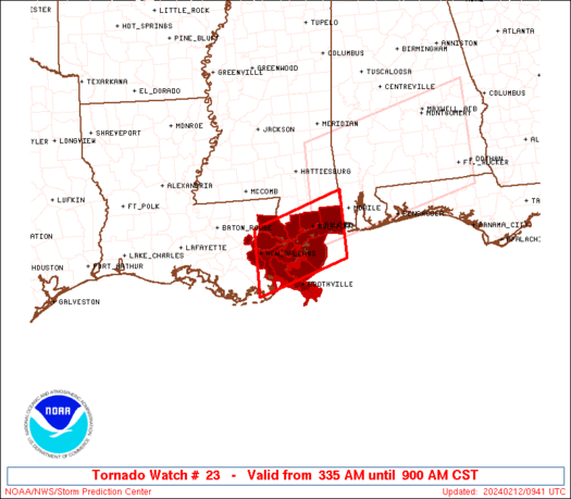
Tornado Watch Number 23
NWS Storm Prediction Center Norman OK
335 AM CST Mon Feb 12 2024
The NWS Storm Prediction Center has issued a
* Tornado Watch for portions of
Southeast Louisiana
Far Southern Mississippi
Coastal Waters
* Effective this Monday morning from 335 AM until 900 AM CST.
* Primary threats include...
A couple tornadoes possible
Isolated damaging wind gusts to 65 mph possible
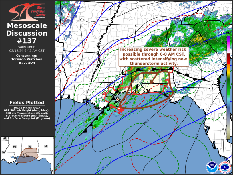
SUMMARY...A severe-weather risk including isolated tornado/damaging
wind potential will continue through the early morning hours.
The tornado watch area is approximately along and 45 statute miles
north and south of a line from 15 miles south southwest of New
Orleans LA to 40 miles east of Gulfport MS. For a complete depiction
of the watch see the associated watch outline update (WOUS64 KWNS
WOU3).
PRECAUTIONARY/PREPAREDNESS ACTIONS...
REMEMBER...A Tornado Watch means conditions are favorable for
tornadoes and severe thunderstorms in and close to the watch
area. Persons in these areas should be on the lookout for
threatening weather conditions and listen for later statements
and possible warnings.
&&
OTHER WATCH INFORMATION...CONTINUE...WW 22...
AVIATION...Tornadoes and a few severe thunderstorms with hail
surface and aloft to 1.5 inches. Extreme turbulence and surface wind
gusts to 55 knots. A few cumulonimbi with maximum tops to 450. Mean
storm motion vector 24030.
...Guyer
 Note:
The Aviation Watch (SAW) product is an approximation to the watch area.
The actual watch is depicted by the shaded areas.
Note:
The Aviation Watch (SAW) product is an approximation to the watch area.
The actual watch is depicted by the shaded areas.
   SAW3
   WW 23 TORNADO LA MS CW 120935Z - 121500Z
   AXIS..45 STATUTE MILES NORTH AND SOUTH OF LINE..
   15SSW MSY/NEW ORLEANS LA/ - 40E GPT/GULFPORT MS/
   ..AVIATION COORDS.. 40NM N/S /18W HRV - 20S SJI/
   HAIL SURFACE AND ALOFT..1.5 INCHES. WIND GUSTS..55 KNOTS.
   MAX TOPS TO 450. MEAN STORM MOTION VECTOR 24030.

   LAT...LON 30459035 31058840 29758840 29159035

   THIS IS AN APPROXIMATION TO THE WATCH AREA.  FOR A
   COMPLETE DEPICTION OF THE WATCH SEE WOUS64 KWNS
   FOR WOU3.
Watch 23 Status Report Messages:
STATUS REPORT #2 ON WW 23

VALID 121225Z - 121340Z

SEVERE WEATHER THREAT CONTINUES RIGHT OF A LINE FROM 45 ENE BVE
TO 50 S MOB.

..KERR..02/12/24

ATTN...WFO...LIX...

&&

STATUS REPORT FOR WT 23

SEVERE WEATHER THREAT CONTINUES FOR THE FOLLOWING AREAS

GMZ536-121340-

CW

.    ADJACENT COASTAL WATERS INCLUDED ARE

THE WATCH STATUS MESSAGE IS FOR GUIDANCE PURPOSES ONLY.  PLEASE
REFER TO WATCH COUNTY NOTIFICATION STATEMENTS FOR OFFICIAL
INFORMATION ON COUNTIES...INDEPENDENT CITIES AND MARINE ZONES
CLEARED FROM SEVERE THUNDERSTORM AND TORNADO WATCHES.
$$

STATUS REPORT #1 ON WW 23

VALID 121120Z - 121240Z

SEVERE WEATHER THREAT CONTINUES RIGHT OF A LINE FROM 40 SE HUM TO
25 NNE ASD.

..KERR..02/12/24

ATTN...WFO...LIX...

&&

STATUS REPORT FOR WT 23

SEVERE WEATHER THREAT CONTINUES FOR THE FOLLOWING AREAS

LAC075-121240-

LA
.    LOUISIANA PARISHES INCLUDED ARE

PLAQUEMINES
$$


MSC045-047-059-121240-

MS
.    MISSISSIPPI COUNTIES INCLUDED ARE

HANCOCK 	     HARRISON		 JACKSON
$$


GMZ532-534-536-538-121240-

CW

.    ADJACENT COASTAL WATERS INCLUDED ARE

MISSISSIPPI SOUND

LAKE BORGNE

CHANDELEUR SOUND

BRETON SOUND

$$
THE WATCH STATUS MESSAGE IS FOR GUIDANCE PURPOSES ONLY.  PLEASE
REFER TO WATCH COUNTY NOTIFICATION STATEMENTS FOR OFFICIAL
INFORMATION ON COUNTIES...INDEPENDENT CITIES AND MARINE ZONES
CLEARED FROM SEVERE THUNDERSTORM AND TORNADO WATCHES.
$$
Note:
Click for Complete Product Text.
Tornadoes
Probability of 2 or more tornadoes
|
Mod (30%)
|
Probability of 1 or more strong (EF2-EF5) tornadoes
|
Low (5%)
|
Wind
Probability of 10 or more severe wind events
|
Low (20%)
|
Probability of 1 or more wind events > 65 knots
|
Low (<5%)
|
Hail
Probability of 10 or more severe hail events
|
Low (10%)
|
Probability of 1 or more hailstones > 2 inches
|
Low (<5%)
|
Combined Severe Hail/Wind
Probability of 6 or more combined severe hail/wind events
|
Mod (50%)
|
For each watch, probabilities for particular events inside the watch
(listed above in each table) are determined by the issuing forecaster.
The "Low" category contains probability values ranging from less than 2%
to 20% (EF2-EF5 tornadoes), less than 5% to 20% (all other probabilities),
"Moderate" from 30% to 60%, and "High" from 70% to greater than 95%.
High values are bolded and lighter in color to provide awareness of
an increased threat for a particular event.


 @NWSSPC