Note:
The expiration time in the watch graphic is amended if the watch is
replaced, cancelled or extended.
Note:
Note:
The expiration time in the watch graphic is amended if the watch is
replaced, cancelled or extended.
Note: Click for
Watch Status Reports.
SEL4
URGENT - IMMEDIATE BROADCAST REQUESTED
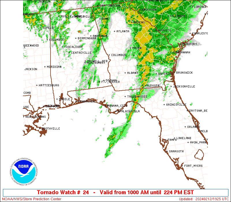
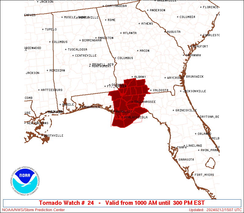
Tornado Watch Number 24
NWS Storm Prediction Center Norman OK
1000 AM EST Mon Feb 12 2024
The NWS Storm Prediction Center has issued a
* Tornado Watch for portions of
Eastern Florida Panhandle
Extreme southwest Georgia
Coastal Waters
* Effective this Monday morning and afternoon from 1000 AM until
300 PM EST.
* Primary threats include...
A couple tornadoes possible
Isolated damaging wind gusts to 60 mph possible
SUMMARY...A band of storms with some embedded bowing/rotating
structures will pose the threat for isolated damaging winds near 60
mph and a tornado or two for the next few hours.
The tornado watch area is approximately along and 50 statute miles
east and west of a line from 35 miles west northwest of Moultrie GA
to 25 miles south southeast of Apalachicola FL. For a complete
depiction of the watch see the associated watch outline update
(WOUS64 KWNS WOU4).
PRECAUTIONARY/PREPAREDNESS ACTIONS...
REMEMBER...A Tornado Watch means conditions are favorable for
tornadoes and severe thunderstorms in and close to the watch
area. Persons in these areas should be on the lookout for
threatening weather conditions and listen for later statements
and possible warnings.
&&
OTHER WATCH INFORMATION...CONTINUE...WW 22...
AVIATION...Tornadoes and a few severe thunderstorms with hail
surface and aloft to 0.5 inches. Extreme turbulence and surface wind
gusts to 50 knots. A few cumulonimbi with maximum tops to 450. Mean
storm motion vector 25035.
...Thompson
 Note:
The Aviation Watch (SAW) product is an approximation to the watch area.
The actual watch is depicted by the shaded areas.
Note:
The Aviation Watch (SAW) product is an approximation to the watch area.
The actual watch is depicted by the shaded areas.
   SAW4
   WW 24 TORNADO FL GA CW 121500Z - 122000Z
   AXIS..50 STATUTE MILES EAST AND WEST OF LINE..
   35WNW MGR/MOULTRIE GA/ - 25SSE AAF/APALACHICOLA FL/
   ..AVIATION COORDS.. 45NM E/W /23S PZD - 75SSW TLH/
   HAIL SURFACE AND ALOFT..0.5 INCH. WIND GUSTS..50 KNOTS.
   MAX TOPS TO 450. MEAN STORM MOTION VECTOR 25035.

   LAT...LON 31278350 29398404 29398570 31278519

   THIS IS AN APPROXIMATION TO THE WATCH AREA.  FOR A
   COMPLETE DEPICTION OF THE WATCH SEE WOUS64 KWNS
   FOR WOU4.
Watch 24 Status Report Messages:
STATUS REPORT #2 ON WW 24
VALID 121825Z - 121940Z
SEVERE WEATHER THREAT CONTINUES RIGHT OF A LINE FROM 20 SSE AAF
TO 15 SSE TLH TO 15 NE MGR.
..GRAMS..02/12/24
ATTN...WFO...TAE...
&&
STATUS REPORT FOR WT 24
SEVERE WEATHER THREAT CONTINUES FOR THE FOLLOWING AREAS
FLC065-121940-
FL
. FLORIDA COUNTIES INCLUDED ARE
JEFFERSON
$$
GAC027-121940-
GA
. GEORGIA COUNTIES INCLUDED ARE
BROOKS
$$
GMZ730-755-121940-
CW
. ADJACENT COASTAL WATERS INCLUDED ARE
APALACHEE BAY OR COASTAL WATERS FROM KEATON BEACH TO OCHLOCKONEE
RIVER FL OUT TO 20 NM
COASTAL WATERS FROM OCHLOCKONEE RIVER TO APALACHICOLA FL OUT TO
20 NM
$$
THE WATCH STATUS MESSAGE IS FOR GUIDANCE PURPOSES ONLY. PLEASE
REFER TO WATCH COUNTY NOTIFICATION STATEMENTS FOR OFFICIAL
INFORMATION ON COUNTIES...INDEPENDENT CITIES AND MARINE ZONES
CLEARED FROM SEVERE THUNDERSTORM AND TORNADO WATCHES.
$$
STATUS REPORT #1 ON WW 24
VALID 121725Z - 121840Z
SEVERE WEATHER THREAT CONTINUES RIGHT OF A LINE FROM 25 SSW AAF
TO 30 WSW TLH TO 25 SW ABY.
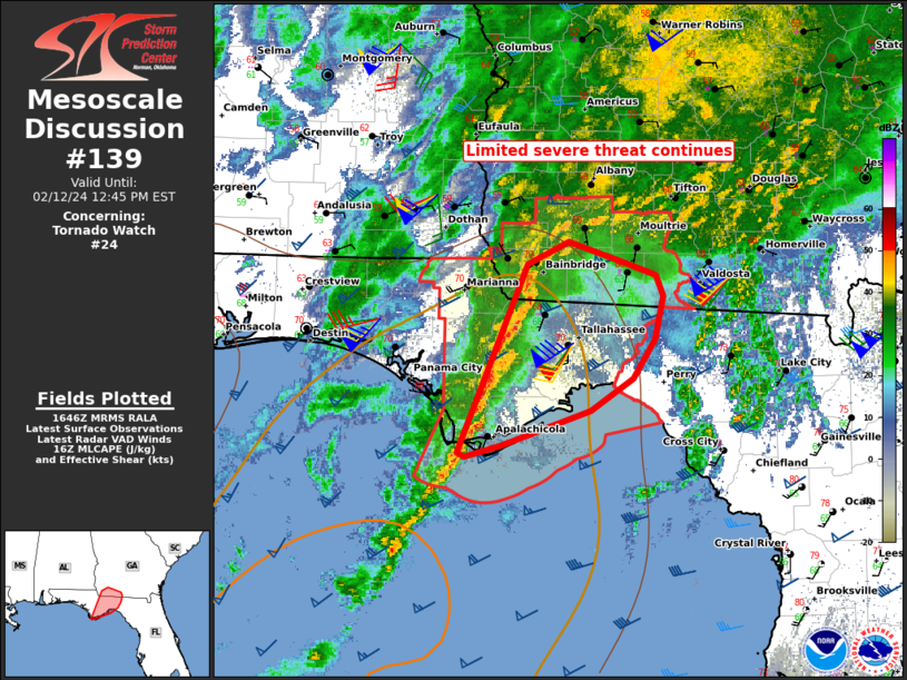
FOR ADDITIONAL INFORMATION SEE MESOSCALE DISCUSSION 139.
..GRAMS..02/12/24
ATTN...WFO...TAE...
&&
STATUS REPORT FOR WT 24
SEVERE WEATHER THREAT CONTINUES FOR THE FOLLOWING AREAS
FLC037-039-065-073-077-129-121840-
FL
. FLORIDA COUNTIES INCLUDED ARE
FRANKLIN GADSDEN JEFFERSON
LEON LIBERTY WAKULLA
$$
GAC007-027-071-087-131-205-275-121840-
GA
. GEORGIA COUNTIES INCLUDED ARE
BAKER BROOKS COLQUITT
DECATUR GRADY MITCHELL
THOMAS
$$
GMZ730-752-755-121840-
CW
. ADJACENT COASTAL WATERS INCLUDED ARE
APALACHEE BAY OR COASTAL WATERS FROM KEATON BEACH TO OCHLOCKONEE
RIVER FL OUT TO 20 NM
COASTAL WATERS FROM MEXICO BEACH TO APALACHICOLA OUT 20 NM
COASTAL WATERS FROM OCHLOCKONEE RIVER TO APALACHICOLA FL OUT TO
20 NM
$$
THE WATCH STATUS MESSAGE IS FOR GUIDANCE PURPOSES ONLY. PLEASE
REFER TO WATCH COUNTY NOTIFICATION STATEMENTS FOR OFFICIAL
INFORMATION ON COUNTIES...INDEPENDENT CITIES AND MARINE ZONES
CLEARED FROM SEVERE THUNDERSTORM AND TORNADO WATCHES.
$$
Note:
Click for Complete Product Text.
Tornadoes
Probability of 2 or more tornadoes
|
Mod (30%)
|
Probability of 1 or more strong (EF2-EF5) tornadoes
|
Low (10%)
|
Wind
Probability of 10 or more severe wind events
|
Mod (30%)
|
Probability of 1 or more wind events > 65 knots
|
Low (10%)
|
Hail
Probability of 10 or more severe hail events
|
Low (<5%)
|
Probability of 1 or more hailstones > 2 inches
|
Low (<5%)
|
Combined Severe Hail/Wind
Probability of 6 or more combined severe hail/wind events
|
Mod (40%)
|
For each watch, probabilities for particular events inside the watch
(listed above in each table) are determined by the issuing forecaster.
The "Low" category contains probability values ranging from less than 2%
to 20% (EF2-EF5 tornadoes), less than 5% to 20% (all other probabilities),
"Moderate" from 30% to 60%, and "High" from 70% to greater than 95%.
High values are bolded and lighter in color to provide awareness of
an increased threat for a particular event.


 @NWSSPC