Note:
The expiration time in the watch graphic is amended if the watch is
replaced, cancelled or extended.
Note:
Note:
The expiration time in the watch graphic is amended if the watch is
replaced, cancelled or extended.
Note: Click for
Watch Status Reports.
SEL9
URGENT - IMMEDIATE BROADCAST REQUESTED
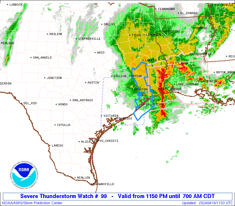
Severe Thunderstorm Watch Number 99
NWS Storm Prediction Center Norman OK
1150 PM CDT Tue Apr 9 2024
The NWS Storm Prediction Center has issued a
* Severe Thunderstorm Watch for portions of
Southeast Texas
Coastal Waters
* Effective this Tuesday night and Wednesday morning from 1150 PM
until 700 AM CDT.
* Primary threats include...
Widespread damaging winds and isolated significant gusts to 85
mph likely
Scattered large hail and isolated very large hail events to 2
inches in diameter possible
A tornado or two possible
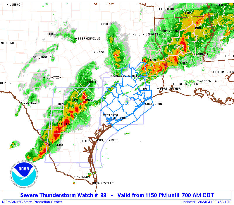
SUMMARY...An intense line of thunderstorms over south Texas will
track eastward overnight across the watch area. The potential
exists for considerable coverage of damaging wind gust and some
hail. Isolated tornadoes are also possible along the leading edge
of the squall line.
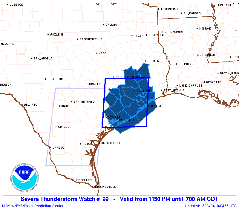
The severe thunderstorm watch area is approximately along and 65
statute miles east and west of a line from 65 miles north northwest
of Houston TX to 30 miles southeast of Palacios TX. For a complete
depiction of the watch see the associated watch outline update
(WOUS64 KWNS WOU9).
PRECAUTIONARY/PREPAREDNESS ACTIONS...
REMEMBER...A Severe Thunderstorm Watch means conditions are
favorable for severe thunderstorms in and close to the watch area.
Persons in these areas should be on the lookout for threatening
weather conditions and listen for later statements and possible
warnings. Severe thunderstorms can and occasionally do produce
tornadoes.
&&
OTHER WATCH INFORMATION...CONTINUE...WW 98...
AVIATION...A few severe thunderstorms with hail surface and aloft to
2 inches. Extreme turbulence and surface wind gusts to 75 knots. A
few cumulonimbi with maximum tops to 500. Mean storm motion vector
26035.
...Hart
 Note:
The Aviation Watch (SAW) product is an approximation to the watch area.
The actual watch is depicted by the shaded areas.
Note:
The Aviation Watch (SAW) product is an approximation to the watch area.
The actual watch is depicted by the shaded areas.
   SAW9
   WW 99 SEVERE TSTM TX CW 100450Z - 101200Z
   AXIS..65 STATUTE MILES EAST AND WEST OF LINE..
   65NNW HOU/HOUSTON TX/ - 30SE PSX/PALACIOS TX/
   ..AVIATION COORDS.. 55NM E/W /38NNW IAH - 30SE PSX/
   HAIL SURFACE AND ALOFT..2 INCHES. WIND GUSTS..75 KNOTS.
   MAX TOPS TO 500. MEAN STORM MOTION VECTOR 26035.

   LAT...LON 30519461 28429483 28429697 30519679

   THIS IS AN APPROXIMATION TO THE WATCH AREA.  FOR A
   COMPLETE DEPICTION OF THE WATCH SEE WOUS64 KWNS
   FOR WOU9.
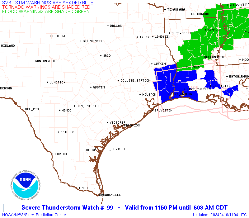
Watch 99 Status Report Messages:
STATUS REPORT #3 ON WW 99
VALID 100925Z - 101040Z
SEVERE WEATHER THREAT CONTINUES RIGHT OF A LINE FROM 40 ESE PSX
TO 35 SSE UTS TO 15 SW UTS.
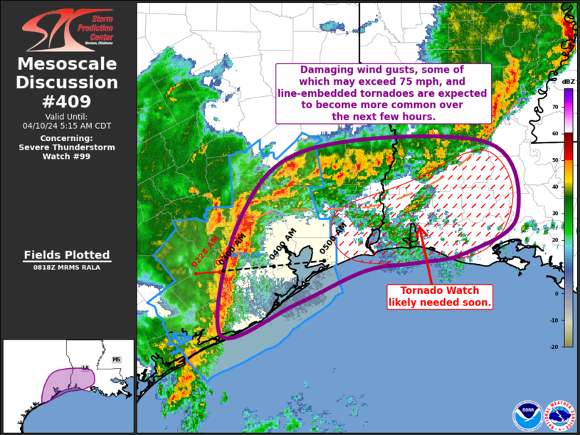
FOR ADDITIONAL INFORMATION SEE MESOSCALE DISCUSSION 409
..MOSIER..04/10/24
ATTN...WFO...HGX...
&&
STATUS REPORT FOR WS 99
SEVERE WEATHER THREAT CONTINUES FOR THE FOLLOWING AREAS
TXC039-071-167-291-373-407-471-101040-
TX
. TEXAS COUNTIES INCLUDED ARE
BRAZORIA CHAMBERS GALVESTON
LIBERTY POLK SAN JACINTO
WALKER
$$
GMZ335-355-101040-
CW
. ADJACENT COASTAL WATERS INCLUDED ARE
GALVESTON BAY
COASTAL WATERS FROM HIGH ISLAND TO FREEPORT TX OUT 20 NM
$$
THE WATCH STATUS MESSAGE IS FOR GUIDANCE PURPOSES ONLY. PLEASE
REFER TO WATCH COUNTY NOTIFICATION STATEMENTS FOR OFFICIAL
INFORMATION ON COUNTIES...INDEPENDENT CITIES AND MARINE ZONES
CLEARED FROM SEVERE THUNDERSTORM AND TORNADO WATCHES.
$$
STATUS REPORT #2 ON WW 99
VALID 100735Z - 100840Z
THE SEVERE WEATHER THREAT CONTINUES ACROSS THE ENTIRE WATCH AREA.
FOR ADDITIONAL INFORMATION SEE MESOSCALE DISCUSSION 408
..MOSIER..04/10/24
ATTN...WFO...HGX...
&&
STATUS REPORT FOR WS 99
SEVERE WEATHER THREAT CONTINUES FOR THE FOLLOWING AREAS
TXC015-039-071-089-157-167-201-239-291-321-339-373-407-471-473-
481-100840-
TX
. TEXAS COUNTIES INCLUDED ARE
AUSTIN BRAZORIA CHAMBERS
COLORADO FORT BEND GALVESTON
HARRIS JACKSON LIBERTY
MATAGORDA MONTGOMERY POLK
SAN JACINTO WALKER WALLER
WHARTON
$$
GMZ330-335-350-355-100840-
CW
. ADJACENT COASTAL WATERS INCLUDED ARE
MATAGORDA BAY
GALVESTON BAY
COASTAL WATERS FROM FREEPORT TO MATAGORDA SHIP CHANNEL TX OUT 20
NM
COASTAL WATERS FROM HIGH ISLAND TO FREEPORT TX OUT 20 NM
$$
THE WATCH STATUS MESSAGE IS FOR GUIDANCE PURPOSES ONLY. PLEASE
REFER TO WATCH COUNTY NOTIFICATION STATEMENTS FOR OFFICIAL
INFORMATION ON COUNTIES...INDEPENDENT CITIES AND MARINE ZONES
CLEARED FROM SEVERE THUNDERSTORM AND TORNADO WATCHES.
$$
STATUS REPORT #1 ON WW 99
VALID 100600Z - 100740Z
THE SEVERE WEATHER THREAT CONTINUES ACROSS THE ENTIRE WATCH AREA.
..MOSIER..04/10/24
ATTN...WFO...HGX...
&&
STATUS REPORT FOR WS 99
SEVERE WEATHER THREAT CONTINUES FOR THE FOLLOWING AREAS
TXC015-039-071-089-157-167-201-239-291-321-339-373-407-471-473-
481-100740-
TX
. TEXAS COUNTIES INCLUDED ARE
AUSTIN BRAZORIA CHAMBERS
COLORADO FORT BEND GALVESTON
HARRIS JACKSON LIBERTY
MATAGORDA MONTGOMERY POLK
SAN JACINTO WALKER WALLER
WHARTON
$$
GMZ330-335-350-355-100740-
CW
. ADJACENT COASTAL WATERS INCLUDED ARE
MATAGORDA BAY
GALVESTON BAY
COASTAL WATERS FROM FREEPORT TO MATAGORDA SHIP CHANNEL TX OUT 20
NM
COASTAL WATERS FROM HIGH ISLAND TO FREEPORT TX OUT 20 NM
$$
THE WATCH STATUS MESSAGE IS FOR GUIDANCE PURPOSES ONLY. PLEASE
REFER TO WATCH COUNTY NOTIFICATION STATEMENTS FOR OFFICIAL
INFORMATION ON COUNTIES...INDEPENDENT CITIES AND MARINE ZONES
CLEARED FROM SEVERE THUNDERSTORM AND TORNADO WATCHES.
$$
Note:
Click for Complete Product Text.
Tornadoes
Probability of 2 or more tornadoes
|
Low (20%)
|
Probability of 1 or more strong (EF2-EF5) tornadoes
|
Low (10%)
|
Wind
Probability of 10 or more severe wind events
|
High (80%)
|
Probability of 1 or more wind events > 65 knots
|
Mod (60%)
|
Hail
Probability of 10 or more severe hail events
|
Mod (50%)
|
Probability of 1 or more hailstones > 2 inches
|
Mod (50%)
|
Combined Severe Hail/Wind
Probability of 6 or more combined severe hail/wind events
|
High (>95%)
|
For each watch, probabilities for particular events inside the watch
(listed above in each table) are determined by the issuing forecaster.
The "Low" category contains probability values ranging from less than 2%
to 20% (EF2-EF5 tornadoes), less than 5% to 20% (all other probabilities),
"Moderate" from 30% to 60%, and "High" from 70% to greater than 95%.
High values are bolded and lighter in color to provide awareness of
an increased threat for a particular event.


 @NWSSPC