 Note:
The expiration time in the watch graphic is amended if the watch is
replaced, cancelled or extended.
Note:
Note:
The expiration time in the watch graphic is amended if the watch is
replaced, cancelled or extended.
Note: Click for
Watch Status Reports.
SEL0
URGENT - IMMEDIATE BROADCAST REQUESTED
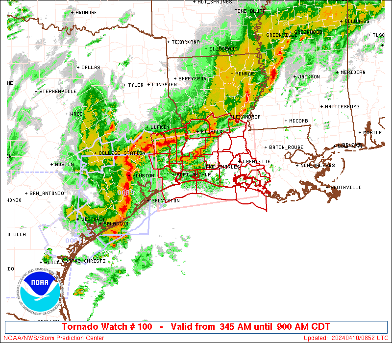
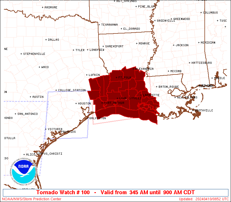
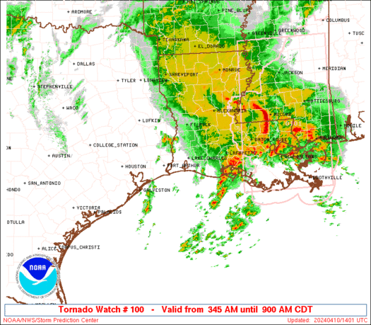
Tornado Watch Number 100
NWS Storm Prediction Center Norman OK
345 AM CDT Wed Apr 10 2024
The NWS Storm Prediction Center has issued a
* Tornado Watch for portions of
Southern Louisiana
Southeast Texas
Coastal Waters
* Effective this Wednesday morning from 345 AM until 900 AM CDT.
* Primary threats include...
A couple tornadoes possible
Scattered damaging winds and isolated significant gusts to 80
mph likely
Isolated large hail events to 1 inch in diameter possible
SUMMARY...A squall line will likely intensify as it accelerates
eastward through the early morning across the northwest Gulf Coastal
plain. Tornadoes are possible with any longer lived mesovortex or
supercell that can develop ahead of the squall line. The risk for
damaging gusts will likely increase through the early morning as the
squall line moves into southwest and southern Louisiana.
The tornado watch area is approximately along and 65 statute miles
north and south of a line from 30 miles west of Port Arthur TX to 30
miles east of Lafayette LA. For a complete depiction of the watch
see the associated watch outline update (WOUS64 KWNS WOU0).
PRECAUTIONARY/PREPAREDNESS ACTIONS...
REMEMBER...A Tornado Watch means conditions are favorable for
tornadoes and severe thunderstorms in and close to the watch
area. Persons in these areas should be on the lookout for
threatening weather conditions and listen for later statements
and possible warnings.
&&
OTHER WATCH INFORMATION...CONTINUE...WW 98...WW 99...
AVIATION...Tornadoes and a few severe thunderstorms with hail
surface and aloft to 1 inch. Extreme turbulence and surface wind
gusts to 70 knots. A few cumulonimbi with maximum tops to 500. Mean
storm motion vector 25040.
...Smith
 Note:
The Aviation Watch (SAW) product is an approximation to the watch area.
The actual watch is depicted by the shaded areas.
Note:
The Aviation Watch (SAW) product is an approximation to the watch area.
The actual watch is depicted by the shaded areas.
   SAW0
   WW 100 TORNADO LA TX CW 100845Z - 101400Z
   AXIS..65 STATUTE MILES NORTH AND SOUTH OF LINE..
   30W BPT/PORT ARTHUR TX/ - 30E LFT/LAFAYETTE LA/
   ..AVIATION COORDS.. 55NM N/S /43E IAH - 19SSW BTR/
   HAIL SURFACE AND ALOFT..1 INCH. WIND GUSTS..70 KNOTS.
   MAX TOPS TO 500. MEAN STORM MOTION VECTOR 25040.

   LAT...LON 30899452 31149148 29269148 29019452

   THIS IS AN APPROXIMATION TO THE WATCH AREA.  FOR A
   COMPLETE DEPICTION OF THE WATCH SEE WOUS64 KWNS
   FOR WOU0.
Watch 100 Status Report Messages:
STATUS REPORT #2 ON WW 100

VALID 101325Z - 101440Z

SEVERE WEATHER THREAT CONTINUES RIGHT OF A LINE FROM 55 SW 7R4 TO
15 NW LFT TO 35 NNE LFT TO 15 ENE ESF.

..LEITMAN..04/10/24

ATTN...WFO...LCH...

&&

STATUS REPORT FOR WT 100

SEVERE WEATHER THREAT CONTINUES FOR THE FOLLOWING AREAS

LAC045-055-099-101-113-101440-

LA
.    LOUISIANA PARISHES INCLUDED ARE

IBERIA		     LAFAYETTE		 ST. MARTIN
ST. MARY	     VERMILION
$$


GMZ435-436-452-455-101440-

CW

.    ADJACENT COASTAL WATERS INCLUDED ARE

VERMILION BAY


COASTAL WATERS FROM INTRACOASTAL CITY TO CAMERON LA OUT 20 NM

COASTAL WATERS FROM LOWER ATCHAFALAYA RIVER TO INTRACOASTAL CITY
LA OUT 20 NM

$$
THE WATCH STATUS MESSAGE IS FOR GUIDANCE PURPOSES ONLY.  PLEASE
REFER TO WATCH COUNTY NOTIFICATION STATEMENTS FOR OFFICIAL
INFORMATION ON COUNTIES...INDEPENDENT CITIES AND MARINE ZONES
CLEARED FROM SEVERE THUNDERSTORM AND TORNADO WATCHES.
$$

STATUS REPORT #1 ON WW 100

VALID 101120Z - 101240Z

SEVERE WEATHER THREAT CONTINUES RIGHT OF A LINE FROM 50 ESE GLS
TO 40 W POE.

FOR ADDITIONAL INFORMATION SEE MESOSCALE DISCUSSION 411

..MOSIER..04/10/24

ATTN...WFO...LCH...

&&

STATUS REPORT FOR WT 100

SEVERE WEATHER THREAT CONTINUES FOR THE FOLLOWING AREAS

LAC001-003-009-011-019-023-039-045-053-055-079-097-099-101-113-
115-101240-

LA
.    LOUISIANA PARISHES INCLUDED ARE

ACADIA		     ALLEN		 AVOYELLES
BEAUREGARD	     CALCASIEU		 CAMERON
EVANGELINE	     IBERIA		 JEFFERSON DAVIS
LAFAYETTE	     RAPIDES		 ST. LANDRY
ST. MARTIN	     ST. MARY		 VERMILION
VERNON
$$


TXC351-101240-

TX
.    TEXAS COUNTIES INCLUDED ARE

NEWTON
$$


GMZ430-432-435-436-450-452-455-101240-

CW

.    ADJACENT COASTAL WATERS INCLUDED ARE

SABINE LAKE

CALCASIEU LAKE

VERMILION BAY


COASTAL WATERS FROM CAMERON LA TO HIGH ISLAND TX OUT 20 NM

COASTAL WATERS FROM INTRACOASTAL CITY TO CAMERON LA OUT 20 NM

COASTAL WATERS FROM LOWER ATCHAFALAYA RIVER TO INTRACOASTAL CITY
LA OUT 20 NM

$$
THE WATCH STATUS MESSAGE IS FOR GUIDANCE PURPOSES ONLY.  PLEASE
REFER TO WATCH COUNTY NOTIFICATION STATEMENTS FOR OFFICIAL
INFORMATION ON COUNTIES...INDEPENDENT CITIES AND MARINE ZONES
CLEARED FROM SEVERE THUNDERSTORM AND TORNADO WATCHES.
$$
Note:
Click for Complete Product Text.
Tornadoes
Probability of 2 or more tornadoes
|
Mod (40%)
|
Probability of 1 or more strong (EF2-EF5) tornadoes
|
Low (20%)
|
Wind
Probability of 10 or more severe wind events
|
Mod (60%)
|
Probability of 1 or more wind events > 65 knots
|
Mod (60%)
|
Hail
Probability of 10 or more severe hail events
|
Low (20%)
|
Probability of 1 or more hailstones > 2 inches
|
Low (10%)
|
Combined Severe Hail/Wind
Probability of 6 or more combined severe hail/wind events
|
High (90%)
|
For each watch, probabilities for particular events inside the watch
(listed above in each table) are determined by the issuing forecaster.
The "Low" category contains probability values ranging from less than 2%
to 20% (EF2-EF5 tornadoes), less than 5% to 20% (all other probabilities),
"Moderate" from 30% to 60%, and "High" from 70% to greater than 95%.
High values are bolded and lighter in color to provide awareness of
an increased threat for a particular event.


 @NWSSPC