 Note:
The expiration time in the watch graphic is amended if the watch is
replaced, cancelled or extended.
Note:
Note:
The expiration time in the watch graphic is amended if the watch is
replaced, cancelled or extended.
Note: Click for
Watch Status Reports.
SEL9
URGENT - IMMEDIATE BROADCAST REQUESTED
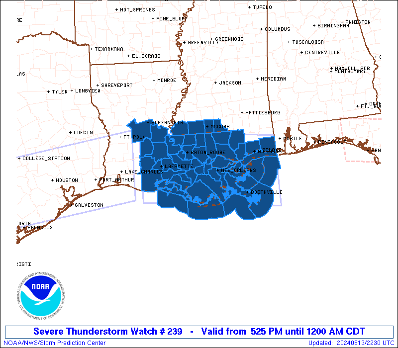
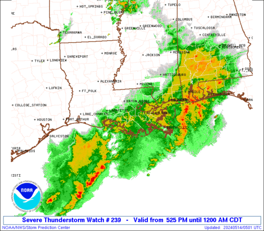
Severe Thunderstorm Watch Number 239
NWS Storm Prediction Center Norman OK
525 PM CDT Mon May 13 2024
The NWS Storm Prediction Center has issued a
* Severe Thunderstorm Watch for portions of
Central and Southeast Louisiana
Southern Mississippi
Coastal Waters
* Effective this Monday afternoon from 525 PM until Midnight CDT.
* Primary threats include...
Scattered damaging winds and isolated significant gusts to 75
mph likely
Scattered large hail and isolated very large hail events to 2
inches in diameter possible
A tornado or two possible
SUMMARY...A fast moving line of thunderstorms over southwest
Louisiana will track across the watch area during the evening.
Damaging winds are the main threat with these storms, along with a
possible tornado or two along the leading edge of activity.
The severe thunderstorm watch area is approximately along and 65
statute miles north and south of a line from 40 miles northwest of
Intracoastal City LA to 55 miles southeast of Gulfport MS. For a
complete depiction of the watch see the associated watch outline
update (WOUS64 KWNS WOU9).
PRECAUTIONARY/PREPAREDNESS ACTIONS...
REMEMBER...A Severe Thunderstorm Watch means conditions are
favorable for severe thunderstorms in and close to the watch area.
Persons in these areas should be on the lookout for threatening
weather conditions and listen for later statements and possible
warnings. Severe thunderstorms can and occasionally do produce
tornadoes.
&&
OTHER WATCH INFORMATION...CONTINUE...WW 236...WW 237...WW 238...
AVIATION...A few severe thunderstorms with hail surface and aloft to
2 inches. Extreme turbulence and surface wind gusts to 65 knots. A
few cumulonimbi with maximum tops to 500. Mean storm motion vector
27035.
...Hart
   SEL9

   URGENT - IMMEDIATE BROADCAST REQUESTED
   Severe Thunderstorm Watch Number 239
   NWS Storm Prediction Center Norman OK
   525 PM CDT Mon May 13 2024

   The NWS Storm Prediction Center has issued a

   * Severe Thunderstorm Watch for portions of
     Central and Southeast Louisiana
     Southern Mississippi
     Coastal Waters

   * Effective this Monday afternoon from 525 PM until Midnight CDT.

   * Primary threats include...
     Scattered damaging winds and isolated significant gusts to 75
       mph likely
     Scattered large hail and isolated very large hail events to 2
       inches in diameter possible
     A tornado or two possible

   SUMMARY...A fast moving line of thunderstorms over southwest
   Louisiana will track across the watch area during the evening.
   Damaging winds are the main threat with these storms, along with a
   possible tornado or two along the leading edge of activity.

   The severe thunderstorm watch area is approximately along and 65
   statute miles north and south of a line from 40 miles northwest of
   Intracoastal City LA to 55 miles southeast of Gulfport MS. For a
   complete depiction of the watch see the associated watch outline
   update (WOUS64 KWNS WOU9).

   PRECAUTIONARY/PREPAREDNESS ACTIONS...

   REMEMBER...A Severe Thunderstorm Watch means conditions are
   favorable for severe thunderstorms in and close to the watch area.
   Persons in these areas should be on the lookout for threatening
   weather conditions and listen for later statements and possible
   warnings. Severe thunderstorms can and occasionally do produce
   tornadoes.

   &&

   OTHER WATCH INFORMATION...CONTINUE...WW 236...WW 237...WW 238...

   AVIATION...A few severe thunderstorms with hail surface and aloft to
   2 inches. Extreme turbulence and surface wind gusts to 65 knots. A
   few cumulonimbi with maximum tops to 500. Mean storm motion vector
   27035.

   ...Hart
 Note:
The Aviation Watch (SAW) product is an approximation to the watch area.
The actual watch is depicted by the shaded areas.
Note:
The Aviation Watch (SAW) product is an approximation to the watch area.
The actual watch is depicted by the shaded areas.
SAW9
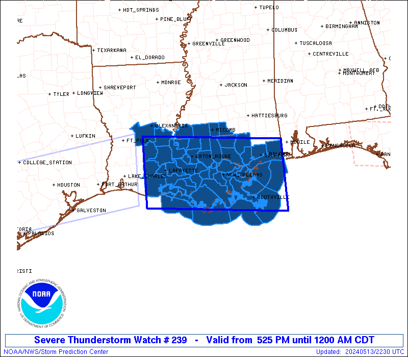
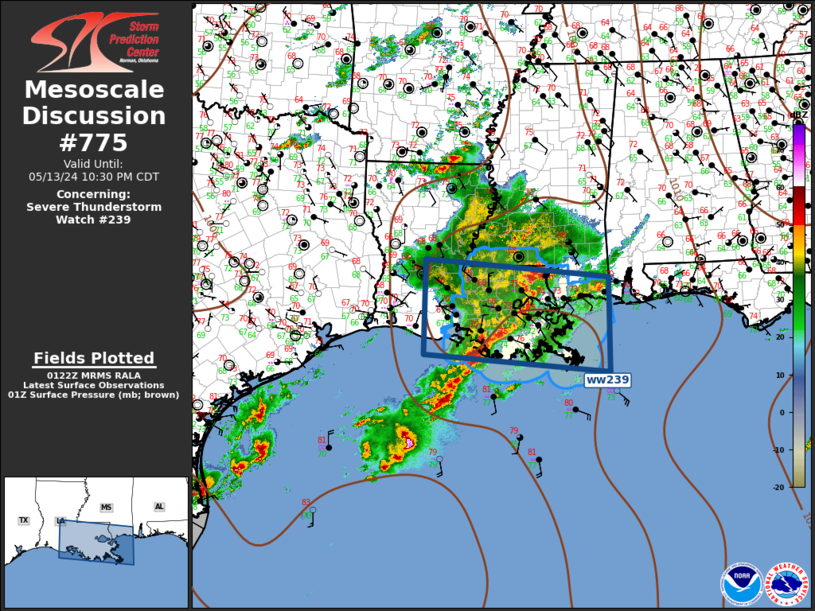
WW 239 SEVERE TSTM LA MS CW 132225Z - 140500Z
AXIS..65 STATUTE MILES NORTH AND SOUTH OF LINE..
40NW 7R4/INTRACOASTAL CITY LA/ - 55SE GPT/GULFPORT MS/
..AVIATION COORDS.. 55NM N/S /26E LCH - 54S SJI/
HAIL SURFACE AND ALOFT..2 INCHES. WIND GUSTS..65 KNOTS.
MAX TOPS TO 500. MEAN STORM MOTION VECTOR 27035.
LAT...LON 31139260 30788842 28898842 29259260
THIS IS AN APPROXIMATION TO THE WATCH AREA. FOR A
COMPLETE DEPICTION OF THE WATCH SEE WOUS64 KWNS
FOR WOU9.
Watch 239 Status Report Messages:
STATUS REPORT #3 ON WW 239

VALID 140245Z - 140340Z

SEVERE WEATHER THREAT CONTINUES RIGHT OF A LINE FROM 35 S HUM TO
40 NNE ASD.

..SPC..05/14/24

ATTN...WFO...LCH...LIX...

&&

STATUS REPORT FOR WS 239

SEVERE WEATHER THREAT CONTINUES FOR THE FOLLOWING AREAS

LAC051-057-071-075-087-140340-

LA
.    LOUISIANA PARISHES INCLUDED ARE

JEFFERSON	     LAFOURCHE		 ORLEANS
PLAQUEMINES	     ST. BERNARD
$$


MSC045-047-059-109-140340-

MS
.    MISSISSIPPI COUNTIES INCLUDED ARE

HANCOCK 	     HARRISON		 JACKSON
PEARL RIVER
$$


GMZ532-534-536-538-550-552-555-557-140340-

CW

.    ADJACENT COASTAL WATERS INCLUDED ARE

MISSISSIPPI SOUND

LAKE BORGNE

CHANDELEUR SOUND

BRETON SOUND

COASTAL WATERS FROM PORT FOURCHON LA TO LOWER ATCHAFALAYA RIVER
LA OUT 20 NM

COASTAL WATERS FROM THE SOUTHWEST PASS OF THE MISSISSIPPI RIVER
TO PORT FOURCHON LOUISIANA OUT 20 NM

COASTAL WATERS FROM BOOTHVILLE LA TO SOUTHWEST PASS OF THE
MISSISSIPPI RIVER OUT 20 NM

COASTAL WATERS FROM PASCAGOULA MISSISSIPPI TO STAKE ISLAND OUT 20
NM

$$
THE WATCH STATUS MESSAGE IS FOR GUIDANCE PURPOSES ONLY.  PLEASE
REFER TO WATCH COUNTY NOTIFICATION STATEMENTS FOR OFFICIAL
INFORMATION ON COUNTIES...INDEPENDENT CITIES AND MARINE ZONES
CLEARED FROM SEVERE THUNDERSTORM AND TORNADO WATCHES.
$$

STATUS REPORT #2 ON WW 239

VALID 140115Z - 140240Z

SEVERE WEATHER THREAT CONTINUES RIGHT OF A LINE FROM 45 SSE 7R4
TO 20 SSE MCB.

..SPC..05/14/24

ATTN...WFO...LCH...LIX...

&&

STATUS REPORT FOR WS 239

SEVERE WEATHER THREAT CONTINUES FOR THE FOLLOWING AREAS

LAC005-007-051-057-063-071-075-087-089-091-093-095-101-103-105-
109-117-140240-

LA
.    LOUISIANA PARISHES INCLUDED ARE

ASCENSION	     ASSUMPTION 	 JEFFERSON
LAFOURCHE	     LIVINGSTON 	 ORLEANS
PLAQUEMINES	     ST. BERNARD	 ST. CHARLES
ST. HELENA	     ST. JAMES		 ST. JOHN THE BAPTIST
ST. MARY	     ST. TAMMANY	 TANGIPAHOA
TERREBONNE	     WASHINGTON
$$


MSC045-047-059-109-147-140240-

MS
.    MISSISSIPPI COUNTIES INCLUDED ARE

HANCOCK 	     HARRISON		 JACKSON
PEARL RIVER	     WALTHALL
$$


GMZ436-455-530-532-534-536-538-550-552-555-557-140240-

CW

.    ADJACENT COASTAL WATERS INCLUDED ARE


COASTAL WATERS FROM LOWER ATCHAFALAYA RIVER TO INTRACOASTAL CITY
LA OUT 20 NM

LAKE PONTCHARTRAIN AND LAKE MAUREPAS

MISSISSIPPI SOUND

LAKE BORGNE

CHANDELEUR SOUND

BRETON SOUND

COASTAL WATERS FROM PORT FOURCHON LA TO LOWER ATCHAFALAYA RIVER
LA OUT 20 NM

COASTAL WATERS FROM THE SOUTHWEST PASS OF THE MISSISSIPPI RIVER
TO PORT FOURCHON LOUISIANA OUT 20 NM

COASTAL WATERS FROM BOOTHVILLE LA TO SOUTHWEST PASS OF THE
MISSISSIPPI RIVER OUT 20 NM

COASTAL WATERS FROM PASCAGOULA MISSISSIPPI TO STAKE ISLAND OUT 20
NM

$$
THE WATCH STATUS MESSAGE IS FOR GUIDANCE PURPOSES ONLY.  PLEASE
REFER TO WATCH COUNTY NOTIFICATION STATEMENTS FOR OFFICIAL
INFORMATION ON COUNTIES...INDEPENDENT CITIES AND MARINE ZONES
CLEARED FROM SEVERE THUNDERSTORM AND TORNADO WATCHES.
$$

STATUS REPORT #1 ON WW 239

VALID 140045Z - 140140Z

SEVERE WEATHER THREAT CONTINUES RIGHT OF A LINE FROM 40 SSW 7R4
TO 10 N 7R4 TO 50 E LFT TO 40 S HEZ.

..SPC..05/14/24

ATTN...WFO...LCH...LIX...

&&

STATUS REPORT FOR WS 239

SEVERE WEATHER THREAT CONTINUES FOR THE FOLLOWING AREAS

LAC005-007-033-037-045-047-051-057-063-071-075-087-089-091-093-
095-099-101-103-105-109-117-140140-

LA
.    LOUISIANA PARISHES INCLUDED ARE

ASCENSION	     ASSUMPTION 	 EAST BATON ROUGE
EAST FELICIANA	     IBERIA		 IBERVILLE
JEFFERSON	     LAFOURCHE		 LIVINGSTON
ORLEANS 	     PLAQUEMINES	 ST. BERNARD
ST. CHARLES	     ST. HELENA 	 ST. JAMES
ST. JOHN THE BAPTIST ST. MARTIN 	 ST. MARY
ST. TAMMANY	     TANGIPAHOA 	 TERREBONNE
WASHINGTON
$$


MSC005-045-047-059-109-113-147-140140-

MS
.    MISSISSIPPI COUNTIES INCLUDED ARE

AMITE		     HANCOCK		 HARRISON
JACKSON 	     PEARL RIVER	 PIKE
WALTHALL
$$


GMZ435-436-455-530-532-534-536-538-550-552-555-557-140140-

CW

.    ADJACENT COASTAL WATERS INCLUDED ARE

VERMILION BAY


COASTAL WATERS FROM LOWER ATCHAFALAYA RIVER TO INTRACOASTAL CITY
LA OUT 20 NM

LAKE PONTCHARTRAIN AND LAKE MAUREPAS

MISSISSIPPI SOUND

LAKE BORGNE

CHANDELEUR SOUND

BRETON SOUND

COASTAL WATERS FROM PORT FOURCHON LA TO LOWER ATCHAFALAYA RIVER
LA OUT 20 NM

COASTAL WATERS FROM THE SOUTHWEST PASS OF THE MISSISSIPPI RIVER
TO PORT FOURCHON LOUISIANA OUT 20 NM

COASTAL WATERS FROM BOOTHVILLE LA TO SOUTHWEST PASS OF THE
MISSISSIPPI RIVER OUT 20 NM

COASTAL WATERS FROM PASCAGOULA MISSISSIPPI TO STAKE ISLAND OUT 20
NM

$$
THE WATCH STATUS MESSAGE IS FOR GUIDANCE PURPOSES ONLY.  PLEASE
REFER TO WATCH COUNTY NOTIFICATION STATEMENTS FOR OFFICIAL
INFORMATION ON COUNTIES...INDEPENDENT CITIES AND MARINE ZONES
CLEARED FROM SEVERE THUNDERSTORM AND TORNADO WATCHES.
$$
Note:
Click for Complete Product Text.
Tornadoes
Probability of 2 or more tornadoes
|
Low (20%)
|
Probability of 1 or more strong (EF2-EF5) tornadoes
|
Low (5%)
|
Wind
Probability of 10 or more severe wind events
|
High (70%)
|
Probability of 1 or more wind events > 65 knots
|
Mod (60%)
|
Hail
Probability of 10 or more severe hail events
|
Mod (40%)
|
Probability of 1 or more hailstones > 2 inches
|
Mod (40%)
|
Combined Severe Hail/Wind
Probability of 6 or more combined severe hail/wind events
|
High (90%)
|
For each watch, probabilities for particular events inside the watch
(listed above in each table) are determined by the issuing forecaster.
The "Low" category contains probability values ranging from less than 2%
to 20% (EF2-EF5 tornadoes), less than 5% to 20% (all other probabilities),
"Moderate" from 30% to 60%, and "High" from 70% to greater than 95%.
High values are bolded and lighter in color to provide awareness of
an increased threat for a particular event.


 @NWSSPC