 Note:
The expiration time in the watch graphic is amended if the watch is
replaced, cancelled or extended.
Note:
Note:
The expiration time in the watch graphic is amended if the watch is
replaced, cancelled or extended.
Note: Click for
Watch Status Reports.
SEL4
URGENT - IMMEDIATE BROADCAST REQUESTED
Severe Thunderstorm Watch Number 244
NWS Storm Prediction Center Norman OK
1050 AM EDT Wed May 15 2024
The NWS Storm Prediction Center has issued a
* Severe Thunderstorm Watch for portions of
Northern/central Florida Peninsula
Coastal Waters
* Effective this Wednesday morning and afternoon from 1050 AM
until 500 PM EDT.
* Primary threats include...
Scattered damaging wind gusts to 70 mph possible
Scattered large hail events to 1.5 inches in diameter possible
A tornado or two possible
SUMMARY...Thunderstorms will spread eastward across parts of the
northern/central FL Peninsula through this afternoon, while posing a
threat for mainly large hail and damaging winds.
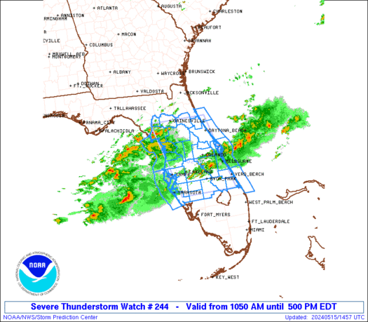
The severe thunderstorm watch area is approximately along and 60
statute miles east and west of a line from 15 miles east of
Gainesville FL to 30 miles south of Avon Park FL. For a complete
depiction of the watch see the associated watch outline update
(WOUS64 KWNS WOU4).
PRECAUTIONARY/PREPAREDNESS ACTIONS...
REMEMBER...A Severe Thunderstorm Watch means conditions are
favorable for severe thunderstorms in and close to the watch area.
Persons in these areas should be on the lookout for threatening
weather conditions and listen for later statements and possible
warnings. Severe thunderstorms can and occasionally do produce
tornadoes.
&&
OTHER WATCH INFORMATION...This severe thunderstorm watch replaces
tornado watch number 243. Watch number 243 will not be in effect
after 1050 AM EDT.
AVIATION...A few severe thunderstorms with hail surface and aloft to
1.5 inches. Extreme turbulence and surface wind gusts to 60 knots. A
few cumulonimbi with maximum tops to 500. Mean storm motion vector
26035.
...Gleason
   SEL4

   URGENT - IMMEDIATE BROADCAST REQUESTED
   Severe Thunderstorm Watch Number 244
   NWS Storm Prediction Center Norman OK
   1050 AM EDT Wed May 15 2024

   The NWS Storm Prediction Center has issued a

   * Severe Thunderstorm Watch for portions of
     Northern/central Florida Peninsula
     Coastal Waters

   * Effective this Wednesday morning and afternoon from 1050 AM
     until 500 PM EDT.

   * Primary threats include...
     Scattered damaging wind gusts to 70 mph possible
     Scattered large hail events to 1.5 inches in diameter possible
     A tornado or two possible

   SUMMARY...Thunderstorms will spread eastward across parts of the
   northern/central FL Peninsula through this afternoon, while posing a
   threat for mainly large hail and damaging winds.

   The severe thunderstorm watch area is approximately along and 60
   statute miles east and west of a line from 15 miles east of
   Gainesville FL to 30 miles south of Avon Park FL. For a complete
   depiction of the watch see the associated watch outline update
   (WOUS64 KWNS WOU4).

   PRECAUTIONARY/PREPAREDNESS ACTIONS...

   REMEMBER...A Severe Thunderstorm Watch means conditions are
   favorable for severe thunderstorms in and close to the watch area.
   Persons in these areas should be on the lookout for threatening
   weather conditions and listen for later statements and possible
   warnings. Severe thunderstorms can and occasionally do produce
   tornadoes.

   &&

   OTHER WATCH INFORMATION...This severe thunderstorm watch replaces
   tornado watch number 243. Watch number 243 will not be in effect
   after 1050 AM EDT.

   AVIATION...A few severe thunderstorms with hail surface and aloft to
   1.5 inches. Extreme turbulence and surface wind gusts to 60 knots. A
   few cumulonimbi with maximum tops to 500. Mean storm motion vector
   26035.

   ...Gleason
 Note:
The Aviation Watch (SAW) product is an approximation to the watch area.
The actual watch is depicted by the shaded areas.
Note:
The Aviation Watch (SAW) product is an approximation to the watch area.
The actual watch is depicted by the shaded areas.
   SAW4
   WW 244 SEVERE TSTM FL CW 151450Z - 152100Z
   AXIS..60 STATUTE MILES EAST AND WEST OF LINE..
   15E GNV/GAINESVILLE FL/ - 30S AGR/AVON PARK FL/
   ..AVIATION COORDS.. 50NM E/W /48SW CRG - 48NNE RSW/
   HAIL SURFACE AND ALOFT..1.5 INCHES. WIND GUSTS..60 KNOTS.
   MAX TOPS TO 500. MEAN STORM MOTION VECTOR 26035.

   REPLACES WW 243..FL CW

   LAT...LON 29688101 27218035 27218231 29688302

   THIS IS AN APPROXIMATION TO THE WATCH AREA.  FOR A
   COMPLETE DEPICTION OF THE WATCH SEE WOUS64 KWNS
   FOR WOU4.
Watch 244 Status Report Messages:
STATUS REPORT #5 ON WW 244

VALID 151940Z - 152040Z

SEVERE WEATHER THREAT CONTINUES RIGHT OF A LINE FROM 35 SSE VRB
TO 20 N DAB TO 30 NE DAB.

..GLEASON..05/15/24

ATTN...WFO...JAX...MLB...TBW...

&&

STATUS REPORT FOR WS 244

SEVERE WEATHER THREAT CONTINUES FOR THE FOLLOWING AREAS

AMZ550-552-555-152040-

CW

.    ADJACENT COASTAL WATERS INCLUDED ARE

THE WATCH STATUS MESSAGE IS FOR GUIDANCE PURPOSES ONLY.  PLEASE
REFER TO WATCH COUNTY NOTIFICATION STATEMENTS FOR OFFICIAL
INFORMATION ON COUNTIES...INDEPENDENT CITIES AND MARINE ZONES
CLEARED FROM SEVERE THUNDERSTORM AND TORNADO WATCHES.
$$

STATUS REPORT #4 ON WW 244

VALID 151845Z - 151940Z

THE SEVERE WEATHER THREAT CONTINUES ACROSS THE ENTIRE WATCH AREA.

..GLEASON..05/15/24

ATTN...WFO...JAX...MLB...TBW...

&&

STATUS REPORT FOR WS 244

SEVERE WEATHER THREAT CONTINUES FOR THE FOLLOWING AREAS

FLC001-009-017-027-035-041-049-053-055-057-061-069-075-081-083-
093-095-097-101-103-105-107-111-115-117-119-127-151940-

FL
.    FLORIDA COUNTIES INCLUDED ARE

ALACHUA 	     BREVARD		 CITRUS
DESOTO		     FLAGLER		 GILCHRIST
HARDEE		     HERNANDO		 HIGHLANDS
HILLSBOROUGH	     INDIAN RIVER	 LAKE
LEVY		     MANATEE		 MARION
OKEECHOBEE	     ORANGE		 OSCEOLA
PASCO		     PINELLAS		 POLK
PUTNAM		     ST. LUCIE		 SARASOTA
SEMINOLE	     SUMTER		 VOLUSIA
$$


AMZ454-550-552-555-GMZ830-850-853-151940-

CW

.    ADJACENT COASTAL WATERS INCLUDED ARE

COASTAL WATERS FROM ST. AUGUSTINE TO FLAGLER BEACH FL OUT 20 NM

FLAGLER BEACH TO VOLUSIA-BREVARD COUNTY LINE 0-20 NM

VOLUSIA-BREVARD COUNTY LINE TO SEBASTIAN INLET 0-20 NM

SEBASTIAN INLET TO JUPITER INLET 0-20 NM

TAMPA BAY WATERS

COASTAL WATERS FROM TARPON SPRINGS TO SUWANNEE RIVER FL OUT 20 NM

COASTAL WATERS FROM ENGLEWOOD TO TARPON SPRINGS FL OUT 20 NM

$$
THE WATCH STATUS MESSAGE IS FOR GUIDANCE PURPOSES ONLY.  PLEASE
REFER TO WATCH COUNTY NOTIFICATION STATEMENTS FOR OFFICIAL
INFORMATION ON COUNTIES...INDEPENDENT CITIES AND MARINE ZONES
CLEARED FROM SEVERE THUNDERSTORM AND TORNADO WATCHES.
$$

STATUS REPORT #3 ON WW 244

VALID 151740Z - 151840Z

THE SEVERE WEATHER THREAT CONTINUES ACROSS THE ENTIRE WATCH AREA.

FOR ADDITIONAL INFORMATION SEE MESOSCALE DISCUSSION 792

..GLEASON..05/15/24

ATTN...WFO...JAX...MLB...TBW...

&&

STATUS REPORT FOR WS 244

SEVERE WEATHER THREAT CONTINUES FOR THE FOLLOWING AREAS

FLC001-009-017-027-035-041-049-053-055-057-061-069-075-081-083-
093-095-097-101-103-105-107-111-115-117-119-127-151840-

FL
.    FLORIDA COUNTIES INCLUDED ARE

ALACHUA 	     BREVARD		 CITRUS
DESOTO		     FLAGLER		 GILCHRIST
HARDEE		     HERNANDO		 HIGHLANDS
HILLSBOROUGH	     INDIAN RIVER	 LAKE
LEVY		     MANATEE		 MARION
OKEECHOBEE	     ORANGE		 OSCEOLA
PASCO		     PINELLAS		 POLK
PUTNAM		     ST. LUCIE		 SARASOTA
SEMINOLE	     SUMTER		 VOLUSIA
$$


AMZ454-550-552-555-GMZ830-850-853-151840-

CW

.    ADJACENT COASTAL WATERS INCLUDED ARE

COASTAL WATERS FROM ST. AUGUSTINE TO FLAGLER BEACH FL OUT 20 NM

FLAGLER BEACH TO VOLUSIA-BREVARD COUNTY LINE 0-20 NM

VOLUSIA-BREVARD COUNTY LINE TO SEBASTIAN INLET 0-20 NM

SEBASTIAN INLET TO JUPITER INLET 0-20 NM

TAMPA BAY WATERS

COASTAL WATERS FROM TARPON SPRINGS TO SUWANNEE RIVER FL OUT 20 NM

COASTAL WATERS FROM ENGLEWOOD TO TARPON SPRINGS FL OUT 20 NM

$$
THE WATCH STATUS MESSAGE IS FOR GUIDANCE PURPOSES ONLY.  PLEASE
REFER TO WATCH COUNTY NOTIFICATION STATEMENTS FOR OFFICIAL
INFORMATION ON COUNTIES...INDEPENDENT CITIES AND MARINE ZONES
CLEARED FROM SEVERE THUNDERSTORM AND TORNADO WATCHES.
$$

STATUS REPORT #2 ON WW 244

VALID 151645Z - 151740Z

THE SEVERE WEATHER THREAT CONTINUES ACROSS THE ENTIRE WATCH AREA.

..GLEASON..05/15/24

ATTN...WFO...JAX...MLB...TBW...

&&

STATUS REPORT FOR WS 244

SEVERE WEATHER THREAT CONTINUES FOR THE FOLLOWING AREAS

FLC001-009-017-027-035-041-049-053-055-057-061-069-075-081-083-
093-095-097-101-103-105-107-111-115-117-119-127-151740-

FL
.    FLORIDA COUNTIES INCLUDED ARE

ALACHUA 	     BREVARD		 CITRUS
DESOTO		     FLAGLER		 GILCHRIST
HARDEE		     HERNANDO		 HIGHLANDS
HILLSBOROUGH	     INDIAN RIVER	 LAKE
LEVY		     MANATEE		 MARION
OKEECHOBEE	     ORANGE		 OSCEOLA
PASCO		     PINELLAS		 POLK
PUTNAM		     ST. LUCIE		 SARASOTA
SEMINOLE	     SUMTER		 VOLUSIA
$$


AMZ454-550-552-555-GMZ830-850-853-151740-

CW

.    ADJACENT COASTAL WATERS INCLUDED ARE

COASTAL WATERS FROM ST. AUGUSTINE TO FLAGLER BEACH FL OUT 20 NM

FLAGLER BEACH TO VOLUSIA-BREVARD COUNTY LINE 0-20 NM

VOLUSIA-BREVARD COUNTY LINE TO SEBASTIAN INLET 0-20 NM

SEBASTIAN INLET TO JUPITER INLET 0-20 NM

TAMPA BAY WATERS

COASTAL WATERS FROM TARPON SPRINGS TO SUWANNEE RIVER FL OUT 20 NM

COASTAL WATERS FROM ENGLEWOOD TO TARPON SPRINGS FL OUT 20 NM

$$
THE WATCH STATUS MESSAGE IS FOR GUIDANCE PURPOSES ONLY.  PLEASE
REFER TO WATCH COUNTY NOTIFICATION STATEMENTS FOR OFFICIAL
INFORMATION ON COUNTIES...INDEPENDENT CITIES AND MARINE ZONES
CLEARED FROM SEVERE THUNDERSTORM AND TORNADO WATCHES.
$$

STATUS REPORT #1 ON WW 244

VALID 151530Z - 151640Z

THE SEVERE WEATHER THREAT CONTINUES ACROSS THE ENTIRE WATCH AREA.

..GLEASON..05/15/24

ATTN...WFO...JAX...MLB...TBW...

&&

STATUS REPORT FOR WS 244

SEVERE WEATHER THREAT CONTINUES FOR THE FOLLOWING AREAS

FLC001-009-017-027-035-041-049-053-055-057-061-069-075-081-083-
093-095-097-101-103-105-107-111-115-117-119-127-151640-

FL
.    FLORIDA COUNTIES INCLUDED ARE

ALACHUA 	     BREVARD		 CITRUS
DESOTO		     FLAGLER		 GILCHRIST
HARDEE		     HERNANDO		 HIGHLANDS
HILLSBOROUGH	     INDIAN RIVER	 LAKE
LEVY		     MANATEE		 MARION
OKEECHOBEE	     ORANGE		 OSCEOLA
PASCO		     PINELLAS		 POLK
PUTNAM		     ST. LUCIE		 SARASOTA
SEMINOLE	     SUMTER		 VOLUSIA
$$


AMZ454-550-552-555-GMZ830-850-853-151640-

CW

.    ADJACENT COASTAL WATERS INCLUDED ARE

COASTAL WATERS FROM ST. AUGUSTINE TO FLAGLER BEACH FL OUT 20 NM

FLAGLER BEACH TO VOLUSIA-BREVARD COUNTY LINE 0-20 NM

VOLUSIA-BREVARD COUNTY LINE TO SEBASTIAN INLET 0-20 NM

SEBASTIAN INLET TO JUPITER INLET 0-20 NM

TAMPA BAY WATERS

COASTAL WATERS FROM TARPON SPRINGS TO SUWANNEE RIVER FL OUT 20 NM

COASTAL WATERS FROM ENGLEWOOD TO TARPON SPRINGS FL OUT 20 NM

$$
THE WATCH STATUS MESSAGE IS FOR GUIDANCE PURPOSES ONLY.  PLEASE
REFER TO WATCH COUNTY NOTIFICATION STATEMENTS FOR OFFICIAL
INFORMATION ON COUNTIES...INDEPENDENT CITIES AND MARINE ZONES
CLEARED FROM SEVERE THUNDERSTORM AND TORNADO WATCHES.
$$
Note:
Click for Complete Product Text.
Tornadoes
Probability of 2 or more tornadoes
|
Low (20%)
|
Probability of 1 or more strong (EF2-EF5) tornadoes
|
Low (10%)
|
Wind
Probability of 10 or more severe wind events
|
Mod (40%)
|
Probability of 1 or more wind events > 65 knots
|
Low (20%)
|
Hail
Probability of 10 or more severe hail events
|
Mod (50%)
|
Probability of 1 or more hailstones > 2 inches
|
Low (20%)
|
Combined Severe Hail/Wind
Probability of 6 or more combined severe hail/wind events
|
High (70%)
|
For each watch, probabilities for particular events inside the watch
(listed above in each table) are determined by the issuing forecaster.
The "Low" category contains probability values ranging from less than 2%
to 20% (EF2-EF5 tornadoes), less than 5% to 20% (all other probabilities),
"Moderate" from 30% to 60%, and "High" from 70% to greater than 95%.
High values are bolded and lighter in color to provide awareness of
an increased threat for a particular event.


 @NWSSPC


