Note:
The expiration time in the watch graphic is amended if the watch is
replaced, cancelled or extended.
Note:
Note:
The expiration time in the watch graphic is amended if the watch is
replaced, cancelled or extended.
Note: Click for
Watch Status Reports.
SEL0
URGENT - IMMEDIATE BROADCAST REQUESTED
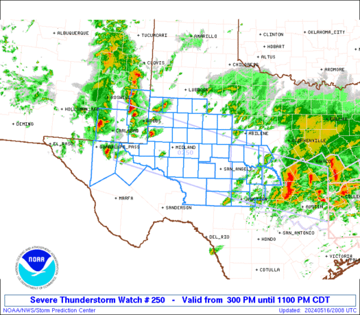
Severe Thunderstorm Watch Number 250
NWS Storm Prediction Center Norman OK
300 PM CDT Thu May 16 2024
The NWS Storm Prediction Center has issued a
* Severe Thunderstorm Watch for portions of
Southeast New Mexico
West Texas into the Edwards Plateau
* Effective this Thursday afternoon and evening from 300 PM until
1100 PM CDT.
* Primary threats include...
Scattered large hail and isolated very large hail events to 2
inches in diameter possible
Scattered damaging wind gusts to 70 mph possible
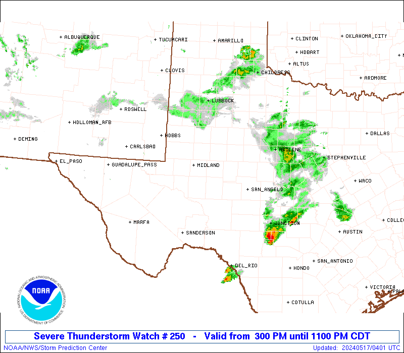
SUMMARY...Thunderstorms will increase in coverage and intensity
through the afternoon/evening while spreading from southeast New
Mexico into west Texas and the Edwards Plateau. The main threats
will be large hail up to 2 inches in diameter with the more discrete
supercells, while severe outflow winds of 60-70 mph will be possible
as storms grow upscale into one or more line segments.
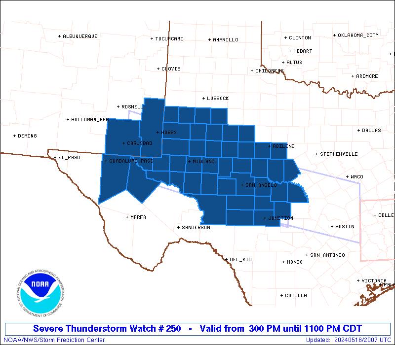
The severe thunderstorm watch area is approximately along and 60
statute miles north and south of a line from 60 miles west southwest
of Hobbs NM to 60 miles northeast of Junction TX. For a complete
depiction of the watch see the associated watch outline update
(WOUS64 KWNS WOU0).
PRECAUTIONARY/PREPAREDNESS ACTIONS...
REMEMBER...A Severe Thunderstorm Watch means conditions are
favorable for severe thunderstorms in and close to the watch area.
Persons in these areas should be on the lookout for threatening
weather conditions and listen for later statements and possible
warnings. Severe thunderstorms can and occasionally do produce
tornadoes.
&&
OTHER WATCH INFORMATION...CONTINUE...WW 248...WW 249...
AVIATION...A few severe thunderstorms with hail surface and aloft to
2 inches. Extreme turbulence and surface wind gusts to 60 knots. A
few cumulonimbi with maximum tops to 500. Mean storm motion vector
29025.
...Thompson
   SEL0

   URGENT - IMMEDIATE BROADCAST REQUESTED
   Severe Thunderstorm Watch Number 250
   NWS Storm Prediction Center Norman OK
   300 PM CDT Thu May 16 2024

   The NWS Storm Prediction Center has issued a

   * Severe Thunderstorm Watch for portions of
     Southeast New Mexico
     West Texas into the Edwards Plateau

   * Effective this Thursday afternoon and evening from 300 PM until
     1100 PM CDT.

   * Primary threats include...
     Scattered large hail and isolated very large hail events to 2
       inches in diameter possible
     Scattered damaging wind gusts to 70 mph possible

   SUMMARY...Thunderstorms will increase in coverage and intensity
   through the afternoon/evening while spreading from southeast New
   Mexico into west Texas and the Edwards Plateau.  The main threats
   will be large hail up to 2 inches in diameter with the more discrete
   supercells, while severe outflow winds of 60-70 mph will be possible
   as storms grow upscale into one or more line segments.

   The severe thunderstorm watch area is approximately along and 60
   statute miles north and south of a line from 60 miles west southwest
   of Hobbs NM to 60 miles northeast of Junction TX. For a complete
   depiction of the watch see the associated watch outline update
   (WOUS64 KWNS WOU0).

   PRECAUTIONARY/PREPAREDNESS ACTIONS...

   REMEMBER...A Severe Thunderstorm Watch means conditions are
   favorable for severe thunderstorms in and close to the watch area.
   Persons in these areas should be on the lookout for threatening
   weather conditions and listen for later statements and possible
   warnings. Severe thunderstorms can and occasionally do produce
   tornadoes.

   &&

   OTHER WATCH INFORMATION...CONTINUE...WW 248...WW 249...

   AVIATION...A few severe thunderstorms with hail surface and aloft to
   2 inches. Extreme turbulence and surface wind gusts to 60 knots. A
   few cumulonimbi with maximum tops to 500. Mean storm motion vector
   29025.

   ...Thompson
 Note:
The Aviation Watch (SAW) product is an approximation to the watch area.
The actual watch is depicted by the shaded areas.
Note:
The Aviation Watch (SAW) product is an approximation to the watch area.
The actual watch is depicted by the shaded areas.
SAW0
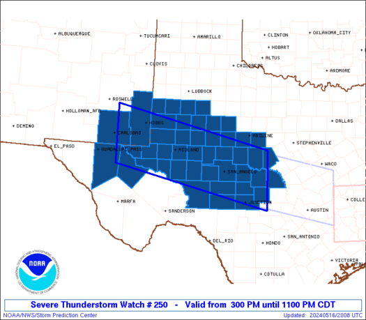
WW 250 SEVERE TSTM NM TX 162000Z - 170400Z
AXIS..60 STATUTE MILES NORTH AND SOUTH OF LINE..
60WSW HOB/HOBBS NM/ - 60NE JCT/JUNCTION TX/
..AVIATION COORDS.. 50NM N/S /55WNW INK - 51NE JCT/
HAIL SURFACE AND ALOFT..2 INCHES. WIND GUSTS..60 KNOTS.
MAX TOPS TO 500. MEAN STORM MOTION VECTOR 29025.
LAT...LON 33210417 32009905 30269905 31480417
THIS IS AN APPROXIMATION TO THE WATCH AREA. FOR A
COMPLETE DEPICTION OF THE WATCH SEE WOUS64 KWNS
FOR WOU0.
Watch 250 Status Report Messages:
STATUS REPORT #5 ON WW 250
VALID 170305Z - 170440Z
SEVERE WEATHER THREAT CONTINUES RIGHT OF A LINE FROM 55 SSW SJT
TO 20 SSE SJT TO 15 S BWD.
..BENTLEY..05/17/24
ATTN...WFO...MAF...SJT...LUB...
&&
STATUS REPORT FOR WS 250
SEVERE WEATHER THREAT CONTINUES FOR THE FOLLOWING AREAS
TXC095-267-307-319-327-411-413-435-170440-
TX
. TEXAS COUNTIES INCLUDED ARE
CONCHO KIMBLE MCCULLOCH
MASON MENARD SAN SABA
SCHLEICHER SUTTON
$$
THE WATCH STATUS MESSAGE IS FOR GUIDANCE PURPOSES ONLY. PLEASE
REFER TO WATCH COUNTY NOTIFICATION STATEMENTS FOR OFFICIAL
INFORMATION ON COUNTIES...INDEPENDENT CITIES AND MARINE ZONES
CLEARED FROM SEVERE THUNDERSTORM AND TORNADO WATCHES.
$$
STATUS REPORT #4 ON WW 250
VALID 170220Z - 170340Z
SEVERE WEATHER THREAT CONTINUES RIGHT OF A LINE FROM 65 SW SJT TO
35 SW SJT TO SJT TO 30 NNE SJT TO 40 SW ABI TO 35 W ABI.
..BENTLEY..05/17/24
ATTN...WFO...MAF...SJT...LUB...
&&
STATUS REPORT FOR WS 250
SEVERE WEATHER THREAT CONTINUES FOR THE FOLLOWING AREAS
TXC049-059-083-095-105-151-267-307-319-327-399-411-413-435-441-
451-170340-
TX
. TEXAS COUNTIES INCLUDED ARE
BROWN CALLAHAN COLEMAN
CONCHO CROCKETT FISHER
KIMBLE MCCULLOCH MASON
MENARD RUNNELS SAN SABA
SCHLEICHER SUTTON TAYLOR
TOM GREEN
$$
THE WATCH STATUS MESSAGE IS FOR GUIDANCE PURPOSES ONLY. PLEASE
REFER TO WATCH COUNTY NOTIFICATION STATEMENTS FOR OFFICIAL
INFORMATION ON COUNTIES...INDEPENDENT CITIES AND MARINE ZONES
CLEARED FROM SEVERE THUNDERSTORM AND TORNADO WATCHES.
$$
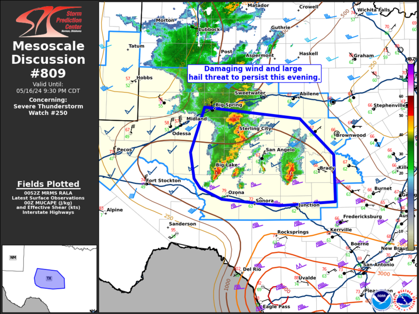
STATUS REPORT #3 ON WW 250
VALID 170100Z - 170240Z
SEVERE WEATHER THREAT CONTINUES RIGHT OF A LINE FROM 60 NNE 6R6
TO 60 W SJT TO 45 WNW SJT TO 30 SE BGS TO 20 ESE BGS TO 30 ENE
BGS TO 50 NE BGS.
FOR ADDITIONAL INFORMATION SEE MESOSCALE DISCUSSION 809
..BENTLEY..05/17/24
ATTN...WFO...MAF...SJT...LUB...
&&
STATUS REPORT FOR WS 250
SEVERE WEATHER THREAT CONTINUES FOR THE FOLLOWING AREAS
TXC049-059-081-083-095-105-151-235-267-307-319-327-335-353-383-
399-411-413-415-431-435-441-451-170240-
TX
. TEXAS COUNTIES INCLUDED ARE
BROWN CALLAHAN COKE
COLEMAN CONCHO CROCKETT
FISHER IRION KIMBLE
MCCULLOCH MASON MENARD
MITCHELL NOLAN REAGAN
RUNNELS SAN SABA SCHLEICHER
SCURRY STERLING SUTTON
TAYLOR TOM GREEN
$$
THE WATCH STATUS MESSAGE IS FOR GUIDANCE PURPOSES ONLY. PLEASE
REFER TO WATCH COUNTY NOTIFICATION STATEMENTS FOR OFFICIAL
INFORMATION ON COUNTIES...INDEPENDENT CITIES AND MARINE ZONES
CLEARED FROM SEVERE THUNDERSTORM AND TORNADO WATCHES.
$$
STATUS REPORT #2 ON WW 250
VALID 170000Z - 170140Z
SEVERE WEATHER THREAT CONTINUES RIGHT OF A LINE FROM 30 E FST TO
40 S MAF TO 20 SSE MAF TO 5 NE MAF TO 20 NNE MAF TO 45 NE BGS.
..BENTLEY..05/16/24
ATTN...WFO...MAF...SJT...LUB...
&&
STATUS REPORT FOR WS 250
SEVERE WEATHER THREAT CONTINUES FOR THE FOLLOWING AREAS
TXC033-049-059-081-083-095-105-151-173-227-235-267-307-317-319-
327-329-335-353-383-399-411-413-415-431-435-441-451-461-
170140-
TX
. TEXAS COUNTIES INCLUDED ARE
BORDEN BROWN CALLAHAN
COKE COLEMAN CONCHO
CROCKETT FISHER GLASSCOCK
HOWARD IRION KIMBLE
MCCULLOCH MARTIN MASON
MENARD MIDLAND MITCHELL
NOLAN REAGAN RUNNELS
SAN SABA SCHLEICHER SCURRY
STERLING SUTTON TAYLOR
TOM GREEN UPTON
$$
THE WATCH STATUS MESSAGE IS FOR GUIDANCE PURPOSES ONLY. PLEASE
REFER TO WATCH COUNTY NOTIFICATION STATEMENTS FOR OFFICIAL
INFORMATION ON COUNTIES...INDEPENDENT CITIES AND MARINE ZONES
CLEARED FROM SEVERE THUNDERSTORM AND TORNADO WATCHES.
$$
STATUS REPORT #1 ON WW 250
VALID 162315Z - 170040Z
SEVERE WEATHER THREAT CONTINUES RIGHT OF A LINE FROM 10 NNE FST
TO 40 ESE INK TO 30 WNW MAF TO 20 WSW LBB.
..BENTLEY..05/16/24
ATTN...WFO...MAF...SJT...LUB...
&&
STATUS REPORT FOR WS 250
SEVERE WEATHER THREAT CONTINUES FOR THE FOLLOWING AREAS
TXC003-033-049-059-081-083-095-103-105-115-135-151-165-169-173-
227-235-267-305-307-317-319-327-329-335-353-383-399-411-413-415-
431-435-441-445-451-461-170040-
TX
. TEXAS COUNTIES INCLUDED ARE
ANDREWS BORDEN BROWN
CALLAHAN COKE COLEMAN
CONCHO CRANE CROCKETT
DAWSON ECTOR FISHER
GAINES GARZA GLASSCOCK
HOWARD IRION KIMBLE
LYNN MCCULLOCH MARTIN
MASON MENARD MIDLAND
MITCHELL NOLAN REAGAN
RUNNELS SAN SABA SCHLEICHER
SCURRY STERLING SUTTON
TAYLOR TERRY TOM GREEN
UPTON
$$
THE WATCH STATUS MESSAGE IS FOR GUIDANCE PURPOSES ONLY. PLEASE
REFER TO WATCH COUNTY NOTIFICATION STATEMENTS FOR OFFICIAL
INFORMATION ON COUNTIES...INDEPENDENT CITIES AND MARINE ZONES
CLEARED FROM SEVERE THUNDERSTORM AND TORNADO WATCHES.
$$
Note:
Click for Complete Product Text.
Tornadoes
Probability of 2 or more tornadoes
|
Low (10%)
|
Probability of 1 or more strong (EF2-EF5) tornadoes
|
Low (<2%)
|
Wind
Probability of 10 or more severe wind events
|
Mod (40%)
|
Probability of 1 or more wind events > 65 knots
|
Low (20%)
|
Hail
Probability of 10 or more severe hail events
|
Mod (40%)
|
Probability of 1 or more hailstones > 2 inches
|
Mod (40%)
|
Combined Severe Hail/Wind
Probability of 6 or more combined severe hail/wind events
|
High (70%)
|
For each watch, probabilities for particular events inside the watch
(listed above in each table) are determined by the issuing forecaster.
The "Low" category contains probability values ranging from less than 2%
to 20% (EF2-EF5 tornadoes), less than 5% to 20% (all other probabilities),
"Moderate" from 30% to 60%, and "High" from 70% to greater than 95%.
High values are bolded and lighter in color to provide awareness of
an increased threat for a particular event.


 @NWSSPC