Note:
The expiration time in the watch graphic is amended if the watch is
replaced, cancelled or extended.
Note:
Note:
The expiration time in the watch graphic is amended if the watch is
replaced, cancelled or extended.
Note: Click for
Watch Status Reports.
SEL0
URGENT - IMMEDIATE BROADCAST REQUESTED
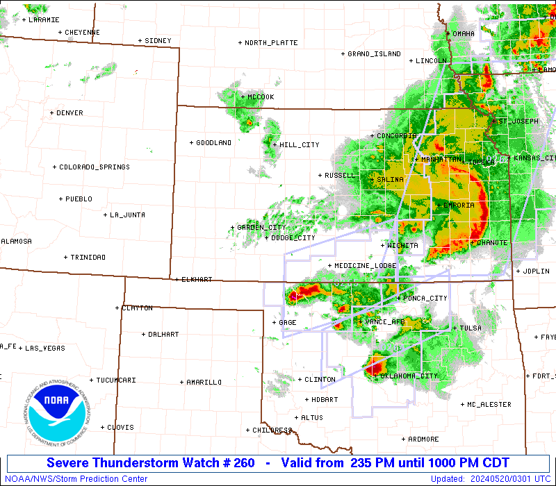
Severe Thunderstorm Watch Number 260
NWS Storm Prediction Center Norman OK
235 PM CDT Sun May 19 2024
The NWS Storm Prediction Center has issued a
* Severe Thunderstorm Watch for portions of
Western and Central Kansas
Northwestern Oklahoma
Northeastern Texas Panhandle
* Effective this Sunday afternoon and evening from 235 PM until
1000 PM CDT.
...THIS IS A PARTICULARLY DANGEROUS SITUATION...
* Primary threats include...
Widespread damaging winds expected with scattered significant
gusts to 90 mph likely
Widespread large hail expected with scattered very large hail
events to 4 inches in diameter likely
A few tornadoes possible
SUMMARY...Numerous severe thunderstorms are expected to develop and
track rapidly eastward across the watch area through the afternoon
evening. Supercells capable of giant hail, damaging winds, and
isolated tornadoes will be the main threat early. Storms will
organize into multiple fast-moving bowing lines through the evening
with a risk of widespread damaging winds.
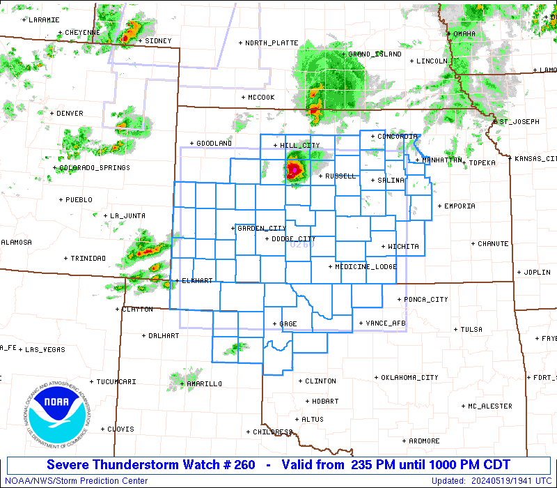
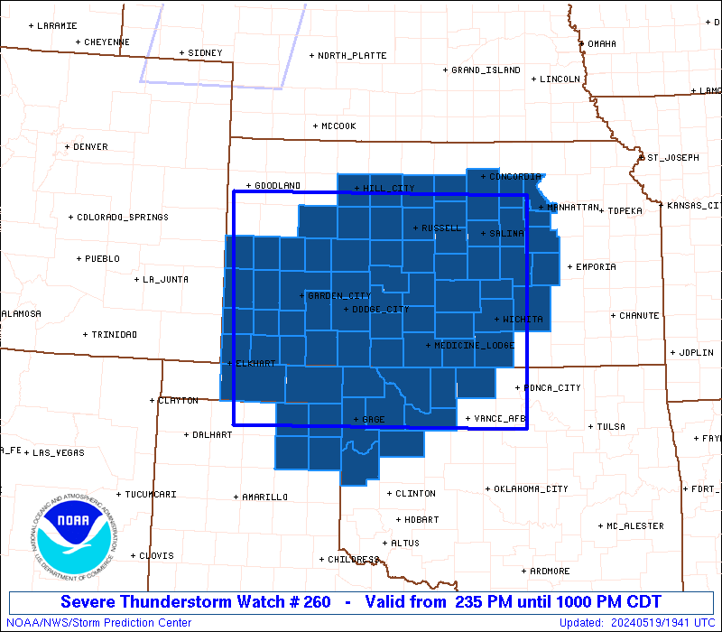
The severe thunderstorm watch area is approximately along and 135
statute miles east and west of a line from 55 miles southwest of
Alva OK to 45 miles northwest of Russell KS. For a complete
depiction of the watch see the associated watch outline update
(WOUS64 KWNS WOU0).
PRECAUTIONARY/PREPAREDNESS ACTIONS...
REMEMBER...A Severe Thunderstorm Watch means conditions are
favorable for severe thunderstorms in and close to the watch area.
Persons in these areas should be on the lookout for threatening
weather conditions and listen for later statements and possible
warnings. Severe thunderstorms can and occasionally do produce
tornadoes.
&&
OTHER WATCH INFORMATION...CONTINUE...WW 258...WW 259...
AVIATION...A few severe thunderstorms with hail surface and aloft to
4 inches. Extreme turbulence and surface wind gusts to 80 knots. A
few cumulonimbi with maximum tops to 500. Mean storm motion vector
24035.
...Hart

   SEL0

   URGENT - IMMEDIATE BROADCAST REQUESTED
   Severe Thunderstorm Watch Number 260
   NWS Storm Prediction Center Norman OK
   235 PM CDT Sun May 19 2024

   The NWS Storm Prediction Center has issued a

   * Severe Thunderstorm Watch for portions of
     Western and Central Kansas
     Northwestern Oklahoma
     Northeastern Texas Panhandle

   * Effective this Sunday afternoon and evening from 235 PM until
     1000 PM CDT.

   ...THIS IS A PARTICULARLY DANGEROUS SITUATION...

   * Primary threats include...
     Widespread damaging winds expected with scattered significant
       gusts to 90 mph likely
     Widespread large hail expected with scattered very large hail
       events to 4 inches in diameter likely
     A few tornadoes possible

   SUMMARY...Numerous severe thunderstorms are expected to develop and
   track rapidly eastward across the watch area through the afternoon
   evening.  Supercells capable of giant hail, damaging winds, and
   isolated tornadoes will be the main threat early.  Storms will
   organize into multiple fast-moving bowing lines through the evening
   with a risk of widespread damaging winds.

   The severe thunderstorm watch area is approximately along and 135
   statute miles east and west of a line from 55 miles southwest of
   Alva OK to 45 miles northwest of Russell KS. For a complete
   depiction of the watch see the associated watch outline update
   (WOUS64 KWNS WOU0).

   PRECAUTIONARY/PREPAREDNESS ACTIONS...

   REMEMBER...A Severe Thunderstorm Watch means conditions are
   favorable for severe thunderstorms in and close to the watch area.
   Persons in these areas should be on the lookout for threatening
   weather conditions and listen for later statements and possible
   warnings. Severe thunderstorms can and occasionally do produce
   tornadoes.

   &&

   OTHER WATCH INFORMATION...CONTINUE...WW 258...WW 259...

   AVIATION...A few severe thunderstorms with hail surface and aloft to
   4 inches. Extreme turbulence and surface wind gusts to 80 knots. A
   few cumulonimbi with maximum tops to 500. Mean storm motion vector
   24035.

   ...Hart
 Note:
The Aviation Watch (SAW) product is an approximation to the watch area.
The actual watch is depicted by the shaded areas.
Note:
The Aviation Watch (SAW) product is an approximation to the watch area.
The actual watch is depicted by the shaded areas.
   SAW0
   WW 260 SEVERE TSTM KS OK TX 191935Z - 200300Z
   AXIS..135 STATUTE MILES EAST AND WEST OF LINE..
   55SW AVK/ALVA OK/ - 45NW RSL/RUSSELL KS/
   ..AVIATION COORDS.. 115NM E/W /26ESE MMB - 38E HLC/
   HAIL SURFACE AND ALOFT..4 INCHES. WIND GUSTS..80 KNOTS.
   MAX TOPS TO 500. MEAN STORM MOTION VECTOR 24035.

   LAT...LON 36180179 39290194 39299689 36189695

   THIS IS AN APPROXIMATION TO THE WATCH AREA.  FOR A
   COMPLETE DEPICTION OF THE WATCH SEE WOUS64 KWNS
   FOR WOU0.
Watch 260 Status Report Messages:
STATUS REPORT #6 ON WW 260
VALID 200130Z - 200240Z
SEVERE WEATHER THREAT CONTINUES RIGHT OF A LINE FROM 25 WSW CSM
TO 45 SE DDC TO 20 NNW HUT TO 40 SSE BIE.
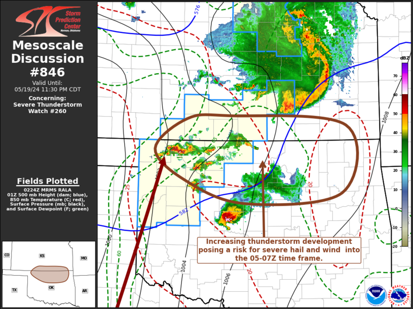
FOR ADDITIONAL INFORMATION SEE MESOSCALE DISCUSSION 842
..MOORE..05/20/24
ATTN...WFO...DDC...ICT...TOP...GLD...GID...OUN...AMA...
&&
STATUS REPORT FOR WS 260
SEVERE WEATHER THREAT CONTINUES FOR THE FOLLOWING AREAS
KSC007-015-017-033-041-061-077-079-095-113-115-127-151-155-161-
173-191-200240-
KS
. KANSAS COUNTIES INCLUDED ARE
BARBER BUTLER CHASE
COMANCHE DICKINSON GEARY
HARPER HARVEY KINGMAN
MCPHERSON MARION MORRIS
PRATT RENO RILEY
SEDGWICK SUMNER
$$
OKC003-039-043-053-093-151-153-200240-
OK
. OKLAHOMA COUNTIES INCLUDED ARE
ALFALFA CUSTER DEWEY
GRANT MAJOR WOODS
WOODWARD
$$
THE WATCH STATUS MESSAGE IS FOR GUIDANCE PURPOSES ONLY. PLEASE
REFER TO WATCH COUNTY NOTIFICATION STATEMENTS FOR OFFICIAL
INFORMATION ON COUNTIES...INDEPENDENT CITIES AND MARINE ZONES
CLEARED FROM SEVERE THUNDERSTORM AND TORNADO WATCHES.
$$
STATUS REPORT #5 ON WW 260
VALID 200055Z - 200140Z
SEVERE WEATHER THREAT CONTINUES RIGHT OF A LINE FROM 50 W CSM TO
70 SE LBL TO 30 S GCK TO 30 WNW GCK TO 40 NE LAA.
FOR ADDITIONAL INFORMATION SEE MESOSCALE DISCUSSION 842
..MOORE..05/20/24
ATTN...WFO...DDC...ICT...TOP...GLD...GID...OUN...AMA...
&&
STATUS REPORT FOR WS 260
SEVERE WEATHER THREAT CONTINUES FOR THE FOLLOWING AREAS
KSC007-009-015-017-025-027-029-033-041-047-051-053-055-057-061-
063-065-069-071-077-079-083-095-097-101-105-113-115-119-123-127-
135-141-143-145-151-155-159-161-163-165-167-169-171-173-185-191-
195-203-200140-
KS
. KANSAS COUNTIES INCLUDED ARE
BARBER BARTON BUTLER
CHASE CLARK CLAY
CLOUD COMANCHE DICKINSON
EDWARDS ELLIS ELLSWORTH
FINNEY FORD GEARY
GOVE GRAHAM GRAY
GREELEY HARPER HARVEY
HODGEMAN KINGMAN KIOWA
LANE LINCOLN MCPHERSON
MARION MEADE MITCHELL
MORRIS NESS OSBORNE
OTTAWA PAWNEE PRATT
RENO RICE RILEY
ROOKS RUSH RUSSELL
SALINE SCOTT SEDGWICK
STAFFORD SUMNER TREGO
WICHITA
$$
OKC003-039-043-045-053-059-093-129-151-153-200140-
OK
. OKLAHOMA COUNTIES INCLUDED ARE
ALFALFA CUSTER DEWEY
ELLIS GRANT HARPER
MAJOR ROGER MILLS WOODS
WOODWARD
$$
THE WATCH STATUS MESSAGE IS FOR GUIDANCE PURPOSES ONLY. PLEASE
REFER TO WATCH COUNTY NOTIFICATION STATEMENTS FOR OFFICIAL
INFORMATION ON COUNTIES...INDEPENDENT CITIES AND MARINE ZONES
CLEARED FROM SEVERE THUNDERSTORM AND TORNADO WATCHES.
$$
STATUS REPORT #4 ON WW 260
VALID 192355Z - 200040Z
SEVERE WEATHER THREAT CONTINUES RIGHT OF A LINE FROM 50 SE BGD TO
30 SSE LBL TO 20 WNW LBL TO 40 NNE EHA TO 25 E LAA.
..MOORE..05/19/24
ATTN...WFO...DDC...ICT...TOP...GLD...GID...OUN...AMA...
&&
STATUS REPORT FOR WS 260
SEVERE WEATHER THREAT CONTINUES FOR THE FOLLOWING AREAS
KSC007-009-015-017-025-027-029-033-041-047-051-053-055-057-061-
063-065-067-069-071-075-077-079-081-083-093-095-097-101-105-113-
115-119-123-127-135-141-143-145-151-155-159-161-163-165-167-169-
171-173-175-185-191-195-203-200040-
KS
. KANSAS COUNTIES INCLUDED ARE
BARBER BARTON BUTLER
CHASE CLARK CLAY
CLOUD COMANCHE DICKINSON
EDWARDS ELLIS ELLSWORTH
FINNEY FORD GEARY
GOVE GRAHAM GRANT
GRAY GREELEY HAMILTON
HARPER HARVEY HASKELL
HODGEMAN KEARNY KINGMAN
KIOWA LANE LINCOLN
MCPHERSON MARION MEADE
MITCHELL MORRIS NESS
OSBORNE OTTAWA PAWNEE
PRATT RENO RICE
RILEY ROOKS RUSH
RUSSELL SALINE SCOTT
SEDGWICK SEWARD STAFFORD
SUMNER TREGO WICHITA
$$
OKC003-007-039-043-045-053-059-093-129-151-153-200040-
OK
. OKLAHOMA COUNTIES INCLUDED ARE
ALFALFA BEAVER CUSTER
DEWEY ELLIS GRANT
HARPER MAJOR ROGER MILLS
WOODS WOODWARD
$$
TXC211-295-200040-
TX
. TEXAS COUNTIES INCLUDED ARE
HEMPHILL LIPSCOMB
$$
THE WATCH STATUS MESSAGE IS FOR GUIDANCE PURPOSES ONLY. PLEASE
REFER TO WATCH COUNTY NOTIFICATION STATEMENTS FOR OFFICIAL
INFORMATION ON COUNTIES...INDEPENDENT CITIES AND MARINE ZONES
CLEARED FROM SEVERE THUNDERSTORM AND TORNADO WATCHES.
$$
STATUS REPORT #3 ON WW 260
VALID 192305Z - 200040Z
SEVERE WEATHER THREAT CONTINUES RIGHT OF A LINE FROM 55 SE BGD TO
30 SSE LBL TO 25 E LAA.
FOR ADDITIONAL INFORMATION SEE MESOSCALE DISCUSSION 839
..MOORE..05/19/24
ATTN...WFO...DDC...ICT...TOP...GLD...GID...OUN...AMA...
&&
STATUS REPORT FOR WS 260
SEVERE WEATHER THREAT CONTINUES FOR THE FOLLOWING AREAS
KSC007-009-015-017-025-027-029-033-041-047-051-053-055-057-061-
063-065-067-069-071-075-077-079-081-083-093-095-097-101-105-113-
115-119-123-127-135-141-143-145-151-155-159-161-163-165-167-169-
171-173-175-185-191-195-203-200040-
KS
. KANSAS COUNTIES INCLUDED ARE
BARBER BARTON BUTLER
CHASE CLARK CLAY
CLOUD COMANCHE DICKINSON
EDWARDS ELLIS ELLSWORTH
FINNEY FORD GEARY
GOVE GRAHAM GRANT
GRAY GREELEY HAMILTON
HARPER HARVEY HASKELL
HODGEMAN KEARNY KINGMAN
KIOWA LANE LINCOLN
MCPHERSON MARION MEADE
MITCHELL MORRIS NESS
OSBORNE OTTAWA PAWNEE
PRATT RENO RICE
RILEY ROOKS RUSH
RUSSELL SALINE SCOTT
SEDGWICK SEWARD STAFFORD
SUMNER TREGO WICHITA
$$
OKC003-007-043-045-053-059-093-129-151-153-200040-
OK
. OKLAHOMA COUNTIES INCLUDED ARE
ALFALFA BEAVER DEWEY
ELLIS GRANT HARPER
MAJOR ROGER MILLS WOODS
WOODWARD
$$
TXC211-295-200040-
TX
. TEXAS COUNTIES INCLUDED ARE
HEMPHILL LIPSCOMB
$$
THE WATCH STATUS MESSAGE IS FOR GUIDANCE PURPOSES ONLY. PLEASE
REFER TO WATCH COUNTY NOTIFICATION STATEMENTS FOR OFFICIAL
INFORMATION ON COUNTIES...INDEPENDENT CITIES AND MARINE ZONES
CLEARED FROM SEVERE THUNDERSTORM AND TORNADO WATCHES.
$$
STATUS REPORT #2 ON WW 260
VALID 192200Z - 192340Z
THE SEVERE WEATHER THREAT CONTINUES ACROSS THE ENTIRE WATCH AREA.
..MOORE..05/19/24
ATTN...WFO...DDC...ICT...TOP...GLD...GID...OUN...AMA...
&&
STATUS REPORT FOR WS 260
SEVERE WEATHER THREAT CONTINUES FOR THE FOLLOWING AREAS
KSC007-009-015-017-025-027-029-033-041-047-051-053-055-057-061-
063-065-067-069-071-075-077-079-081-083-093-095-097-101-105-113-
115-119-123-127-129-135-141-143-145-151-155-159-161-163-165-167-
169-171-173-175-185-187-189-191-195-203-192340-
KS
. KANSAS COUNTIES INCLUDED ARE
BARBER BARTON BUTLER
CHASE CLARK CLAY
CLOUD COMANCHE DICKINSON
EDWARDS ELLIS ELLSWORTH
FINNEY FORD GEARY
GOVE GRAHAM GRANT
GRAY GREELEY HAMILTON
HARPER HARVEY HASKELL
HODGEMAN KEARNY KINGMAN
KIOWA LANE LINCOLN
MCPHERSON MARION MEADE
MITCHELL MORRIS MORTON
NESS OSBORNE OTTAWA
PAWNEE PRATT RENO
RICE RILEY ROOKS
RUSH RUSSELL SALINE
SCOTT SEDGWICK SEWARD
STAFFORD STANTON STEVENS
SUMNER TREGO WICHITA
$$
OKC003-007-043-045-053-059-093-129-139-151-153-192340-
OK
. OKLAHOMA COUNTIES INCLUDED ARE
ALFALFA BEAVER DEWEY
ELLIS GRANT HARPER
MAJOR ROGER MILLS TEXAS
WOODS WOODWARD
$$
TXC211-295-357-393-192340-
TX
. TEXAS COUNTIES INCLUDED ARE
HEMPHILL LIPSCOMB OCHILTREE
ROBERTS
$$
THE WATCH STATUS MESSAGE IS FOR GUIDANCE PURPOSES ONLY. PLEASE
REFER TO WATCH COUNTY NOTIFICATION STATEMENTS FOR OFFICIAL
INFORMATION ON COUNTIES...INDEPENDENT CITIES AND MARINE ZONES
CLEARED FROM SEVERE THUNDERSTORM AND TORNADO WATCHES.
$$
STATUS REPORT #1 ON WW 260
VALID 192055Z - 192140Z
THE SEVERE WEATHER THREAT CONTINUES ACROSS THE ENTIRE WATCH AREA.
..MOORE..05/19/24
ATTN...WFO...DDC...ICT...TOP...GLD...GID...OUN...AMA...
&&
STATUS REPORT FOR WS 260
SEVERE WEATHER THREAT CONTINUES FOR THE FOLLOWING AREAS
KSC007-009-015-017-025-027-029-033-041-047-051-053-055-057-061-
063-065-067-069-071-075-077-079-081-083-093-095-097-101-105-113-
115-119-123-127-129-135-141-143-145-151-155-159-161-163-165-167-
169-171-173-175-185-187-189-191-195-203-192140-
KS
. KANSAS COUNTIES INCLUDED ARE
BARBER BARTON BUTLER
CHASE CLARK CLAY
CLOUD COMANCHE DICKINSON
EDWARDS ELLIS ELLSWORTH
FINNEY FORD GEARY
GOVE GRAHAM GRANT
GRAY GREELEY HAMILTON
HARPER HARVEY HASKELL
HODGEMAN KEARNY KINGMAN
KIOWA LANE LINCOLN
MCPHERSON MARION MEADE
MITCHELL MORRIS MORTON
NESS OSBORNE OTTAWA
PAWNEE PRATT RENO
RICE RILEY ROOKS
RUSH RUSSELL SALINE
SCOTT SEDGWICK SEWARD
STAFFORD STANTON STEVENS
SUMNER TREGO WICHITA
$$
OKC003-007-043-045-053-059-093-129-139-151-153-192140-
OK
. OKLAHOMA COUNTIES INCLUDED ARE
ALFALFA BEAVER DEWEY
ELLIS GRANT HARPER
MAJOR ROGER MILLS TEXAS
WOODS WOODWARD
$$
TXC211-295-357-393-192140-
TX
. TEXAS COUNTIES INCLUDED ARE
HEMPHILL LIPSCOMB OCHILTREE
ROBERTS
$$
THE WATCH STATUS MESSAGE IS FOR GUIDANCE PURPOSES ONLY. PLEASE
REFER TO WATCH COUNTY NOTIFICATION STATEMENTS FOR OFFICIAL
INFORMATION ON COUNTIES...INDEPENDENT CITIES AND MARINE ZONES
CLEARED FROM SEVERE THUNDERSTORM AND TORNADO WATCHES.
$$
Note:
Click for Complete Product Text.
Tornadoes
Probability of 2 or more tornadoes
|
Mod (50%)
|
Probability of 1 or more strong (EF2-EF5) tornadoes
|
Low (20%)
|
Wind
Probability of 10 or more severe wind events
|
High (>95%)
|
Probability of 1 or more wind events > 65 knots
|
High (90%)
|
Hail
Probability of 10 or more severe hail events
|
High (>95%)
|
Probability of 1 or more hailstones > 2 inches
|
High (80%)
|
Combined Severe Hail/Wind
Probability of 6 or more combined severe hail/wind events
|
High (>95%)
|
For each watch, probabilities for particular events inside the watch
(listed above in each table) are determined by the issuing forecaster.
The "Low" category contains probability values ranging from less than 2%
to 20% (EF2-EF5 tornadoes), less than 5% to 20% (all other probabilities),
"Moderate" from 30% to 60%, and "High" from 70% to greater than 95%.
High values are bolded and lighter in color to provide awareness of
an increased threat for a particular event.


 @NWSSPC