Note:
The expiration time in the watch graphic is amended if the watch is
replaced, cancelled or extended.
Note:
Note:
The expiration time in the watch graphic is amended if the watch is
replaced, cancelled or extended.
Note: Click for
Watch Status Reports.
SEL5
URGENT - IMMEDIATE BROADCAST REQUESTED
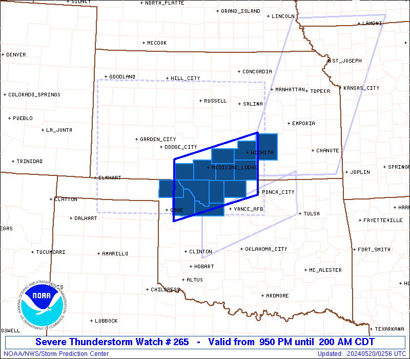
Severe Thunderstorm Watch Number 265
NWS Storm Prediction Center Norman OK
950 PM CDT Sun May 19 2024
The NWS Storm Prediction Center has issued a
* Severe Thunderstorm Watch for portions of
South-Central Kansas
Northwest Oklahoma
* Effective this Sunday night and Monday morning from 950 PM
until 200 AM CDT.
* Primary threats include...
Scattered large hail and isolated very large hail events to 2
inches in diameter possible
Scattered damaging wind gusts to 70 mph possible
SUMMARY...A cluster of severe thunderstorms will likely persist
through the late evening and early overnight hours as a low-level
jet remains situated over the Watch area. Large to very large hail
and severe gusts are the primary hazards with the more intense
storms.
The severe thunderstorm watch area is approximately along and 50
statute miles north and south of a line from 50 miles west of Alva
OK to 25 miles southeast of Wichita KS. For a complete depiction of
the watch see the associated watch outline update (WOUS64 KWNS
WOU5).
PRECAUTIONARY/PREPAREDNESS ACTIONS...
REMEMBER...A Severe Thunderstorm Watch means conditions are
favorable for severe thunderstorms in and close to the watch area.
Persons in these areas should be on the lookout for threatening
weather conditions and listen for later statements and possible
warnings. Severe thunderstorms can and occasionally do produce
tornadoes.
&&
OTHER WATCH INFORMATION...CONTINUE...WW 260...WW 262...WW
263...WW 264...
AVIATION...A few severe thunderstorms with hail surface and aloft to
2 inches. Extreme turbulence and surface wind gusts to 60 knots. A
few cumulonimbi with maximum tops to 550. Mean storm motion vector
26035.
...Smith
 Note:
The Aviation Watch (SAW) product is an approximation to the watch area.
The actual watch is depicted by the shaded areas.
Note:
The Aviation Watch (SAW) product is an approximation to the watch area.
The actual watch is depicted by the shaded areas.
   SAW5
   WW 265 SEVERE TSTM KS OK 200250Z - 200700Z
   AXIS..50 STATUTE MILES NORTH AND SOUTH OF LINE..
   50W AVK/ALVA OK/ - 25SE ICT/WICHITA KS/
   ..AVIATION COORDS.. 45NM N/S /30NNE MMB - 31SE ICT/
   HAIL SURFACE AND ALOFT..2 INCHES. WIND GUSTS..60 KNOTS.
   MAX TOPS TO 550. MEAN STORM MOTION VECTOR 26035.

   LAT...LON 37499957 38129711 36669711 36049957

   THIS IS AN APPROXIMATION TO THE WATCH AREA.  FOR A
   COMPLETE DEPICTION OF THE WATCH SEE WOUS64 KWNS
   FOR WOU5.
Watch 265 Status Report Messages:
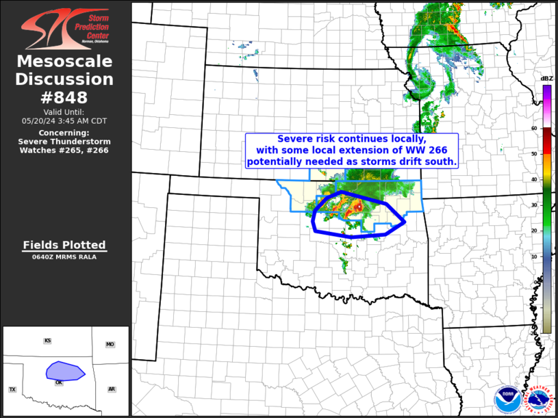
STATUS REPORT #3 ON WW 265

VALID 200545Z - 200640Z

SEVERE WEATHER THREAT CONTINUES RIGHT OF A LINE FROM 45 SSW AVK
TO 30 WNW AVK TO 20 E ICT.

..GOSS..05/20/24

ATTN...WFO...DDC...ICT...OUN...

&&

STATUS REPORT FOR WS 265

SEVERE WEATHER THREAT CONTINUES FOR THE FOLLOWING AREAS

KSC015-077-191-200640-

KS
.    KANSAS COUNTIES INCLUDED ARE

BUTLER		     HARPER		 SUMNER
$$


OKC003-053-093-151-200640-

OK
.    OKLAHOMA COUNTIES INCLUDED ARE

ALFALFA 	     GRANT		 MAJOR
WOODS
$$


THE WATCH STATUS MESSAGE IS FOR GUIDANCE PURPOSES ONLY.  PLEASE
REFER TO WATCH COUNTY NOTIFICATION STATEMENTS FOR OFFICIAL
INFORMATION ON COUNTIES...INDEPENDENT CITIES AND MARINE ZONES
CLEARED FROM SEVERE THUNDERSTORM AND TORNADO WATCHES.
$$

STATUS REPORT #2 ON WW 265

VALID 200440Z - 200540Z

SEVERE WEATHER THREAT CONTINUES RIGHT OF A LINE FROM 55 W AVK TO
10 SSE ICT.

..KERR..05/20/24

ATTN...WFO...DDC...ICT...OUN...

&&

STATUS REPORT FOR WS 265

SEVERE WEATHER THREAT CONTINUES FOR THE FOLLOWING AREAS

KSC015-077-191-200540-

KS
.    KANSAS COUNTIES INCLUDED ARE

BUTLER		     HARPER		 SUMNER
$$


OKC003-053-093-151-200540-

OK
.    OKLAHOMA COUNTIES INCLUDED ARE

ALFALFA 	     GRANT		 MAJOR
WOODS
$$


THE WATCH STATUS MESSAGE IS FOR GUIDANCE PURPOSES ONLY.  PLEASE
REFER TO WATCH COUNTY NOTIFICATION STATEMENTS FOR OFFICIAL
INFORMATION ON COUNTIES...INDEPENDENT CITIES AND MARINE ZONES
CLEARED FROM SEVERE THUNDERSTORM AND TORNADO WATCHES.
$$

STATUS REPORT #1 ON WW 265

VALID 200350Z - 200440Z

THE SEVERE WEATHER THREAT CONTINUES ACROSS THE ENTIRE WATCH AREA.

..KERR..05/20/24

ATTN...WFO...DDC...ICT...OUN...

&&

STATUS REPORT FOR WS 265

SEVERE WEATHER THREAT CONTINUES FOR THE FOLLOWING AREAS

KSC007-015-033-077-095-173-191-200440-

KS
.    KANSAS COUNTIES INCLUDED ARE

BARBER		     BUTLER		 COMANCHE
HARPER		     KINGMAN		 SEDGWICK
SUMNER
$$


OKC003-053-059-093-151-153-200440-

OK
.    OKLAHOMA COUNTIES INCLUDED ARE

ALFALFA 	     GRANT		 HARPER
MAJOR		     WOODS		 WOODWARD
$$


THE WATCH STATUS MESSAGE IS FOR GUIDANCE PURPOSES ONLY.  PLEASE
REFER TO WATCH COUNTY NOTIFICATION STATEMENTS FOR OFFICIAL
INFORMATION ON COUNTIES...INDEPENDENT CITIES AND MARINE ZONES
CLEARED FROM SEVERE THUNDERSTORM AND TORNADO WATCHES.
$$
Note:
Click for Complete Product Text.
Tornadoes
Probability of 2 or more tornadoes
|
Low (10%)
|
Probability of 1 or more strong (EF2-EF5) tornadoes
|
Low (10%)
|
Wind
Probability of 10 or more severe wind events
|
Mod (40%)
|
Probability of 1 or more wind events > 65 knots
|
Low (10%)
|
Hail
Probability of 10 or more severe hail events
|
Mod (40%)
|
Probability of 1 or more hailstones > 2 inches
|
Mod (40%)
|
Combined Severe Hail/Wind
Probability of 6 or more combined severe hail/wind events
|
High (70%)
|
For each watch, probabilities for particular events inside the watch
(listed above in each table) are determined by the issuing forecaster.
The "Low" category contains probability values ranging from less than 2%
to 20% (EF2-EF5 tornadoes), less than 5% to 20% (all other probabilities),
"Moderate" from 30% to 60%, and "High" from 70% to greater than 95%.
High values are bolded and lighter in color to provide awareness of
an increased threat for a particular event.


 @NWSSPC