Note:
The expiration time in the watch graphic is amended if the watch is
replaced, cancelled or extended.
Note:
Note:
The expiration time in the watch graphic is amended if the watch is
replaced, cancelled or extended.
Note: Click for
Watch Status Reports.
SEL7
URGENT - IMMEDIATE BROADCAST REQUESTED
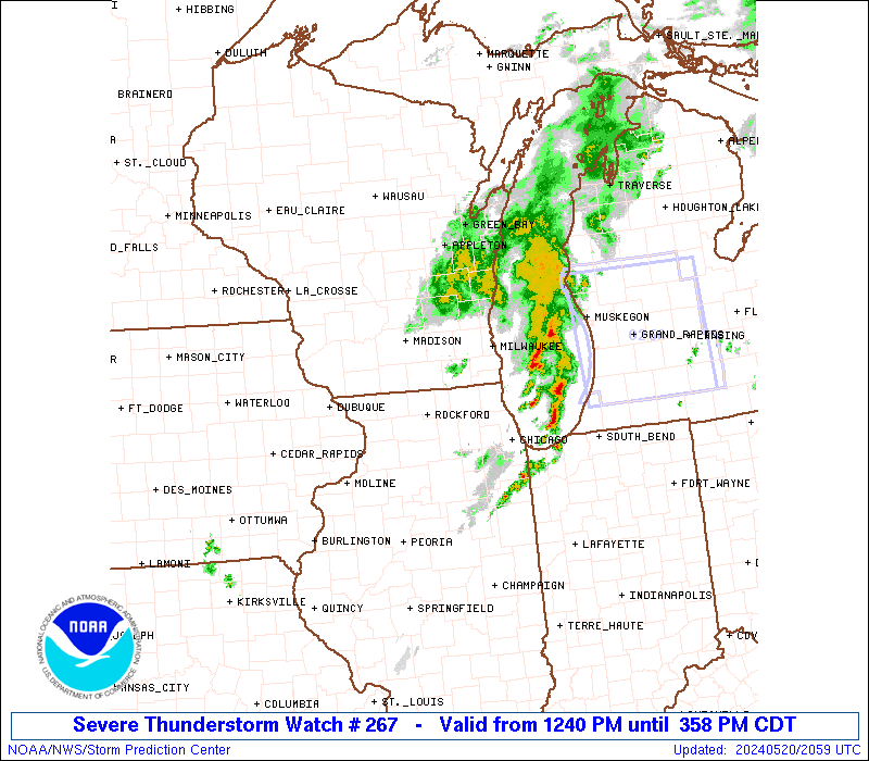
Severe Thunderstorm Watch Number 267
NWS Storm Prediction Center Norman OK
1240 PM CDT Mon May 20 2024
The NWS Storm Prediction Center has issued a
* Severe Thunderstorm Watch for portions of
Northern Illinois
Southeast Wisconsin
Lake Michigan
* Effective this Monday afternoon from 1240 PM until 500 PM CDT.
* Primary threats include...
Scattered large hail and isolated very large hail events to 2
inches in diameter possible
Scattered damaging wind gusts to 65 mph possible
A tornado or two possible
SUMMARY...Scattered thunderstorms are developing ahead of a low over
southwest Wisconsin. These storms may pose a risk of hail and
damaging wind gusts through the afternoon. There is also a small
area of extreme southeast WI with a risk of a tornado or two.
The severe thunderstorm watch area is approximately along and 60
statute miles north and south of a line from 15 miles west northwest
of Janesville WI to 5 miles south southeast of Racine WI. For a
complete depiction of the watch see the associated watch outline
update (WOUS64 KWNS WOU7).
PRECAUTIONARY/PREPAREDNESS ACTIONS...
REMEMBER...A Severe Thunderstorm Watch means conditions are
favorable for severe thunderstorms in and close to the watch area.
Persons in these areas should be on the lookout for threatening
weather conditions and listen for later statements and possible
warnings. Severe thunderstorms can and occasionally do produce
tornadoes.
&&
AVIATION...A few severe thunderstorms with hail surface and aloft to
2 inches. Extreme turbulence and surface wind gusts to 55 knots. A
few cumulonimbi with maximum tops to 500. Mean storm motion vector
26030.
...Hart
 Note:
The Aviation Watch (SAW) product is an approximation to the watch area.
The actual watch is depicted by the shaded areas.
Note:
The Aviation Watch (SAW) product is an approximation to the watch area.
The actual watch is depicted by the shaded areas.
   SAW7
   WW 267 SEVERE TSTM IL WI LM 201740Z - 202200Z
   AXIS..60 STATUTE MILES NORTH AND SOUTH OF LINE..
   15WNW JVL/JANESVILLE WI/ - 5SSE RAC/RACINE WI/
   ..AVIATION COORDS.. 50NM N/S /51WSW BAE - 34SE BAE/
   HAIL SURFACE AND ALOFT..2 INCHES. WIND GUSTS..55 KNOTS.
   MAX TOPS TO 500. MEAN STORM MOTION VECTOR 26030.

   LAT...LON 43578930 43568777 41828777 41838930

   THIS IS AN APPROXIMATION TO THE WATCH AREA.  FOR A
   COMPLETE DEPICTION OF THE WATCH SEE WOUS64 KWNS
   FOR WOU7.
Watch 267 Status Report Messages:
STATUS REPORT #2 ON WW 267

VALID 202030Z - 202140Z

SEVERE WEATHER THREAT CONTINUES RIGHT OF A LINE FROM 20 ENE MMO
TO 25 SW RAC TO 20 ENE MKE.

FOR ADDITIONAL INFORMATION SEE MESOSCALE DISCUSSION 853

..DEAN..05/20/24

ATTN...WFO...LOT...MKX...

&&

STATUS REPORT FOR WS 267

SEVERE WEATHER THREAT CONTINUES FOR THE FOLLOWING AREAS

ILC097-202140-

IL
.    ILLINOIS COUNTIES INCLUDED ARE

LAKE
$$


WIC059-202140-

WI
.    WISCONSIN COUNTIES INCLUDED ARE

KENOSHA
$$


LMZ644-645-646-740-202140-

CW

.    ADJACENT COASTAL WATERS INCLUDED ARE

PORT WASHINGTON TO NORTH POINT LIGHT WI

NORTH POINT LIGHT TO WIND POINT WI

WIND POINT WI TO WINTHROP HARBOR IL

WINTHROP HARBOR TO WILMETTE HARBOR IL

$$
THE WATCH STATUS MESSAGE IS FOR GUIDANCE PURPOSES ONLY.  PLEASE
REFER TO WATCH COUNTY NOTIFICATION STATEMENTS FOR OFFICIAL
INFORMATION ON COUNTIES...INDEPENDENT CITIES AND MARINE ZONES
CLEARED FROM SEVERE THUNDERSTORM AND TORNADO WATCHES.
$$

STATUS REPORT #1 ON WW 267

VALID 201900Z - 202040Z

THE SEVERE WEATHER THREAT CONTINUES ACROSS THE ENTIRE WATCH AREA.

..DEAN..05/20/24

ATTN...WFO...LOT...MKX...

&&

STATUS REPORT FOR WS 267

SEVERE WEATHER THREAT CONTINUES FOR THE FOLLOWING AREAS

ILC007-037-089-097-103-111-141-201-202040-

IL
.    ILLINOIS COUNTIES INCLUDED ARE

BOONE		     DE KALB		 KANE
LAKE		     LEE		 MCHENRY
OGLE		     WINNEBAGO
$$


WIC027-055-059-079-089-101-105-127-131-133-202040-

WI
.    WISCONSIN COUNTIES INCLUDED ARE

DODGE		     JEFFERSON		 KENOSHA
MILWAUKEE	     OZAUKEE		 RACINE
ROCK		     WALWORTH		 WASHINGTON
WAUKESHA
$$


LMZ644-645-646-740-202040-

CW

.    ADJACENT COASTAL WATERS INCLUDED ARE

PORT WASHINGTON TO NORTH POINT LIGHT WI

NORTH POINT LIGHT TO WIND POINT WI

WIND POINT WI TO WINTHROP HARBOR IL

WINTHROP HARBOR TO WILMETTE HARBOR IL

$$
THE WATCH STATUS MESSAGE IS FOR GUIDANCE PURPOSES ONLY.  PLEASE
REFER TO WATCH COUNTY NOTIFICATION STATEMENTS FOR OFFICIAL
INFORMATION ON COUNTIES...INDEPENDENT CITIES AND MARINE ZONES
CLEARED FROM SEVERE THUNDERSTORM AND TORNADO WATCHES.
$$
Note:
Click for Complete Product Text.
Tornadoes
Probability of 2 or more tornadoes
|
Low (20%)
|
Probability of 1 or more strong (EF2-EF5) tornadoes
|
Low (5%)
|
Wind
Probability of 10 or more severe wind events
|
Mod (40%)
|
Probability of 1 or more wind events > 65 knots
|
Low (20%)
|
Hail
Probability of 10 or more severe hail events
|
Mod (40%)
|
Probability of 1 or more hailstones > 2 inches
|
Mod (30%)
|
Combined Severe Hail/Wind
Probability of 6 or more combined severe hail/wind events
|
High (70%)
|
For each watch, probabilities for particular events inside the watch
(listed above in each table) are determined by the issuing forecaster.
The "Low" category contains probability values ranging from less than 2%
to 20% (EF2-EF5 tornadoes), less than 5% to 20% (all other probabilities),
"Moderate" from 30% to 60%, and "High" from 70% to greater than 95%.
High values are bolded and lighter in color to provide awareness of
an increased threat for a particular event.


 @NWSSPC