Note:
The expiration time in the watch graphic is amended if the watch is
replaced, cancelled or extended.
Note:
Note:
The expiration time in the watch graphic is amended if the watch is
replaced, cancelled or extended.
Note: Click for
Watch Status Reports.
SEL0
URGENT - IMMEDIATE BROADCAST REQUESTED
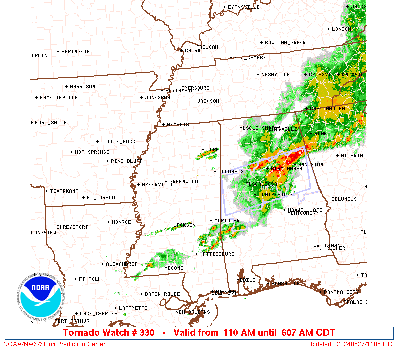
Tornado Watch Number 330
NWS Storm Prediction Center Norman OK
110 AM CDT Mon May 27 2024
The NWS Storm Prediction Center has issued a
* Tornado Watch for portions of
Northern Alabama
Extreme southeastern Arkansas
Extreme northwestern Georgia
Northeastern Louisiana
West-central to northeastern Mississippi
* Effective this Monday morning from 110 AM until 800 AM CDT.
* Primary threats include...
A few tornadoes and a couple intense tornadoes possible
Scattered damaging wind gusts to 70 mph possible
Isolated large hail events to 1.5 inches in diameter possible
SUMMARY...A band of strong-severe thunderstorms is expected to shift
into the watch area through the remainder of the pre-dawn hours,
while a few, more isolated cells form near the southern edge of the
favorable warm-sector air that is relatively uncapped. These will
pose a threat for a few tornadoes, several damaging to severe gusts,
and isolated large hail.
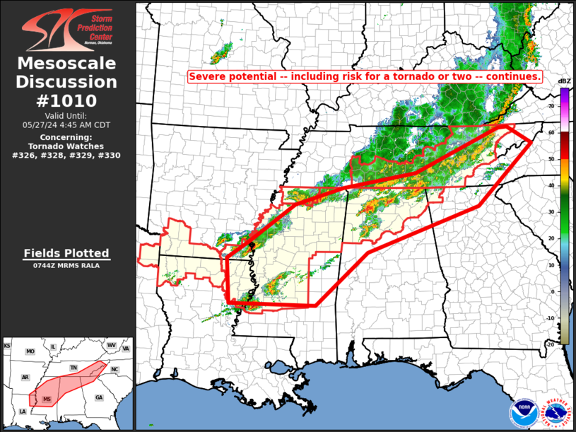
The tornado watch area is approximately along and 40 statute miles
north and south of a line from 70 miles southwest of Greenville MS
to 75 miles east of Huntsville AL. For a complete depiction of the
watch see the associated watch outline update (WOUS64 KWNS WOU0).
PRECAUTIONARY/PREPAREDNESS ACTIONS...
REMEMBER...A Tornado Watch means conditions are favorable for
tornadoes and severe thunderstorms in and close to the watch
area. Persons in these areas should be on the lookout for
threatening weather conditions and listen for later statements
and possible warnings.
&&
OTHER WATCH INFORMATION...CONTINUE...WW 326...WW 327...WW
328...WW 329...
AVIATION...Tornadoes and a few severe thunderstorms with hail
surface and aloft to 1.5 inches. Extreme turbulence and surface wind
gusts to 60 knots. A few cumulonimbi with maximum tops to 500. Mean
storm motion vector 27030.
...Edwards

SEL0
URGENT - IMMEDIATE BROADCAST REQUESTED
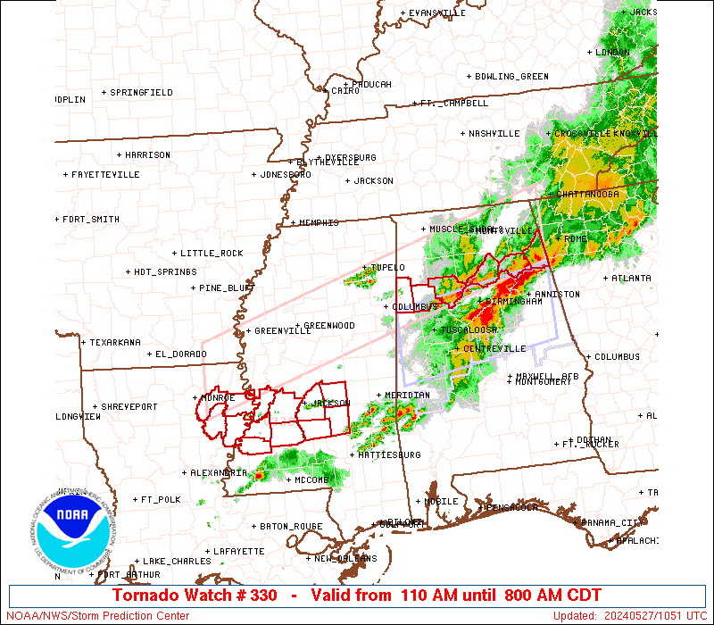
Tornado Watch Number 330
NWS Storm Prediction Center Norman OK
110 AM CDT Mon May 27 2024
The NWS Storm Prediction Center has issued a
* Tornado Watch for portions of
Northern Alabama
Extreme southeastern Arkansas
Extreme northwestern Georgia
Northeastern Louisiana
West-central to northeastern Mississippi
* Effective this Monday morning from 110 AM until 800 AM CDT.
* Primary threats include...
A few tornadoes and a couple intense tornadoes possible
Scattered damaging wind gusts to 70 mph possible
Isolated large hail events to 1.5 inches in diameter possible
SUMMARY...A band of strong-severe thunderstorms is expected to shift
into the watch area through the remainder of the pre-dawn hours,
while a few, more isolated cells form near the southern edge of the
favorable warm-sector air that is relatively uncapped. These will
pose a threat for a few tornadoes, several damaging to severe gusts,
and isolated large hail.
The tornado watch area is approximately along and 40 statute miles
north and south of a line from 70 miles southwest of Greenville MS
to 75 miles east of Huntsville AL. For a complete depiction of the
watch see the associated watch outline update (WOUS64 KWNS WOU0).
PRECAUTIONARY/PREPAREDNESS ACTIONS...
REMEMBER...A Tornado Watch means conditions are favorable for
tornadoes and severe thunderstorms in and close to the watch
area. Persons in these areas should be on the lookout for
threatening weather conditions and listen for later statements
and possible warnings.
&&
OTHER WATCH INFORMATION...CONTINUE...WW 326...WW 327...WW
328...WW 329...
AVIATION...Tornadoes and a few severe thunderstorms with hail
surface and aloft to 1.5 inches. Extreme turbulence and surface wind
gusts to 60 knots. A few cumulonimbi with maximum tops to 500. Mean
storm motion vector 27030.
...Edwards
 Note:
The Aviation Watch (SAW) product is an approximation to the watch area.
The actual watch is depicted by the shaded areas.
Note:
The Aviation Watch (SAW) product is an approximation to the watch area.
The actual watch is depicted by the shaded areas.
SAW0
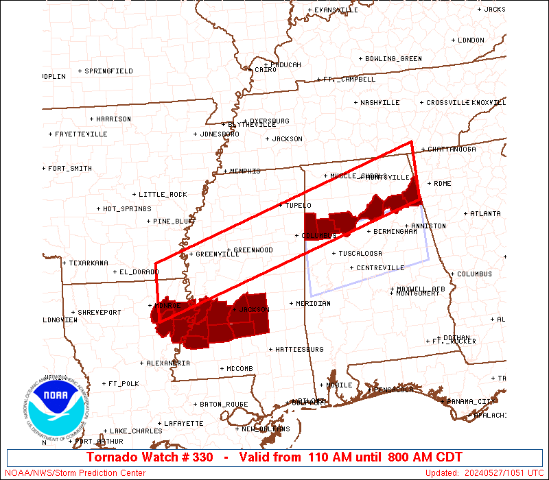
WW 330 TORNADO AL AR GA LA MS 270610Z - 271300Z
AXIS..40 STATUTE MILES NORTH AND SOUTH OF LINE..
70SW GLH/GREENVILLE MS/ - 75E HSV/HUNTSVILLE AL/
..AVIATION COORDS.. 35NM N/S /17NE MLU - 24SW GQO/
HAIL SURFACE AND ALOFT..1.5 INCHES. WIND GUSTS..60 KNOTS.
MAX TOPS TO 500. MEAN STORM MOTION VECTOR 27030.
LAT...LON 33339183 35228546 34068546 32169183
THIS IS AN APPROXIMATION TO THE WATCH AREA. FOR A
COMPLETE DEPICTION OF THE WATCH SEE WOUS64 KWNS
FOR WOU0.
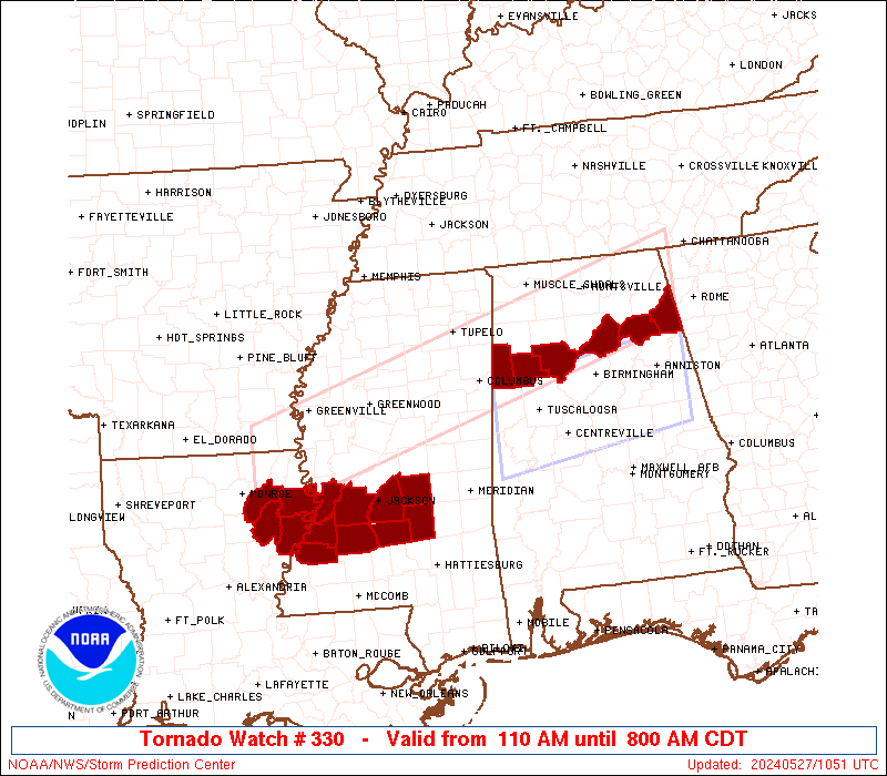
Watch 330 Status Report Messages:
STATUS REPORT #2 ON WW 330

VALID 270845Z - 270940Z

SEVERE WEATHER THREAT CONTINUES RIGHT OF A LINE FROM 35 SSW LLQ
TO 20 SSE GLH TO 20 ENE GWO TO 20 SE UOX.

..GOSS..05/27/24

ATTN...WFO...BMX...HUN...JAN...FFC...MEG...

&&

STATUS REPORT FOR WT 330

SEVERE WEATHER THREAT CONTINUES FOR THE FOLLOWING AREAS

ALC009-019-033-043-049-055-057-059-071-075-079-083-089-093-095-
103-127-133-270940-

AL
.    ALABAMA COUNTIES INCLUDED ARE

BLOUNT		     CHEROKEE		 COLBERT
CULLMAN 	     DEKALB		 ETOWAH
FAYETTE 	     FRANKLIN		 JACKSON
LAMAR		     LAWRENCE		 LIMESTONE
MADISON 	     MARION		 MARSHALL
MORGAN		     WALKER		 WINSTON
$$


GAC047-083-295-270940-

GA
.    GEORGIA COUNTIES INCLUDED ARE

CATOOSA 	     DADE		 WALKER
$$


LAC035-041-065-067-083-107-123-270940-

LA
.    LOUISIANA PARISHES INCLUDED ARE

EAST CARROLL	     FRANKLIN		 MADISON
MOREHOUSE	     RICHLAND		 TENSAS
WEST CARROLL
$$


MSC007-013-015-017-019-021-025-029-049-051-053-055-057-063-079-
081-087-089-095-097-105-115-117-121-123-125-127-129-141-145-149-
155-163-270940-

MS
.    MISSISSIPPI COUNTIES INCLUDED ARE

ATTALA		     CALHOUN		 CARROLL
CHICKASAW	     CHOCTAW		 CLAIBORNE
CLAY		     COPIAH		 HINDS
HOLMES		     HUMPHREYS		 ISSAQUENA
ITAWAMBA	     JEFFERSON		 LEAKE
LEE		     LOWNDES		 MADISON
MONROE		     MONTGOMERY 	 OKTIBBEHA
PONTOTOC	     PRENTISS		 RANKIN
SCOTT		     SHARKEY		 SIMPSON
SMITH		     TISHOMINGO 	 UNION
WARREN		     WEBSTER		 YAZOO
$$


THE WATCH STATUS MESSAGE IS FOR GUIDANCE PURPOSES ONLY.  PLEASE
REFER TO WATCH COUNTY NOTIFICATION STATEMENTS FOR OFFICIAL
INFORMATION ON COUNTIES...INDEPENDENT CITIES AND MARINE ZONES
CLEARED FROM SEVERE THUNDERSTORM AND TORNADO WATCHES.
$$

STATUS REPORT #1 ON WW 330

VALID 270635Z - 270740Z

THE SEVERE WEATHER THREAT CONTINUES ACROSS THE ENTIRE WATCH AREA.

..GOSS..05/27/24

ATTN...WFO...BMX...HUN...JAN...FFC...MEG...

&&

STATUS REPORT FOR WT 330

SEVERE WEATHER THREAT CONTINUES FOR THE FOLLOWING AREAS

ALC009-033-043-049-057-059-071-075-077-079-083-089-093-095-103-
127-133-270740-

AL
.    ALABAMA COUNTIES INCLUDED ARE

BLOUNT		     COLBERT		 CULLMAN
DEKALB		     FAYETTE		 FRANKLIN
JACKSON 	     LAMAR		 LAUDERDALE
LAWRENCE	     LIMESTONE		 MADISON
MARION		     MARSHALL		 MORGAN
WALKER		     WINSTON
$$


ARC003-017-270740-

AR
.    ARKANSAS COUNTIES INCLUDED ARE

ASHLEY		     CHICOT
$$


GAC047-083-295-270740-

GA
.    GEORGIA COUNTIES INCLUDED ARE

CATOOSA 	     DADE		 WALKER
$$


LAC035-041-065-067-083-107-123-270740-

LA
.    LOUISIANA PARISHES INCLUDED ARE

EAST CARROLL	     FRANKLIN		 MADISON
MOREHOUSE	     RICHLAND		 TENSAS
WEST CARROLL
$$


MSC003-007-011-013-015-017-019-025-027-043-051-053-055-057-071-
081-083-087-095-097-105-107-115-117-119-125-133-135-139-141-145-
149-151-155-161-163-270740-

MS
.    MISSISSIPPI COUNTIES INCLUDED ARE

ALCORN		     ATTALA		 BOLIVAR
CALHOUN 	     CARROLL		 CHICKASAW
CHOCTAW 	     CLAY		 COAHOMA
GRENADA 	     HOLMES		 HUMPHREYS
ISSAQUENA	     ITAWAMBA		 LAFAYETTE
LEE		     LEFLORE		 LOWNDES
MONROE		     MONTGOMERY 	 OKTIBBEHA
PANOLA		     PONTOTOC		 PRENTISS
QUITMAN 	     SHARKEY		 SUNFLOWER
TALLAHATCHIE	     TIPPAH		 TISHOMINGO
UNION		     WARREN		 WASHINGTON
WEBSTER 	     YALOBUSHA		 YAZOO
$$


THE WATCH STATUS MESSAGE IS FOR GUIDANCE PURPOSES ONLY.  PLEASE
REFER TO WATCH COUNTY NOTIFICATION STATEMENTS FOR OFFICIAL
INFORMATION ON COUNTIES...INDEPENDENT CITIES AND MARINE ZONES
CLEARED FROM SEVERE THUNDERSTORM AND TORNADO WATCHES.
$$
Note:
Click for Complete Product Text.
Tornadoes
Probability of 2 or more tornadoes
|
Mod (50%)
|
Probability of 1 or more strong (EF2-EF5) tornadoes
|
Mod (30%)
|
Wind
Probability of 10 or more severe wind events
|
Mod (50%)
|
Probability of 1 or more wind events > 65 knots
|
Low (20%)
|
Hail
Probability of 10 or more severe hail events
|
Mod (30%)
|
Probability of 1 or more hailstones > 2 inches
|
Low (20%)
|
Combined Severe Hail/Wind
Probability of 6 or more combined severe hail/wind events
|
High (70%)
|
For each watch, probabilities for particular events inside the watch
(listed above in each table) are determined by the issuing forecaster.
The "Low" category contains probability values ranging from less than 2%
to 20% (EF2-EF5 tornadoes), less than 5% to 20% (all other probabilities),
"Moderate" from 30% to 60%, and "High" from 70% to greater than 95%.
High values are bolded and lighter in color to provide awareness of
an increased threat for a particular event.


 @NWSSPC