 Note:
The expiration time in the watch graphic is amended if the watch is
replaced, cancelled or extended.
Note:
Note:
The expiration time in the watch graphic is amended if the watch is
replaced, cancelled or extended.
Note: Click for
Watch Status Reports.
SEL9
URGENT - IMMEDIATE BROADCAST REQUESTED
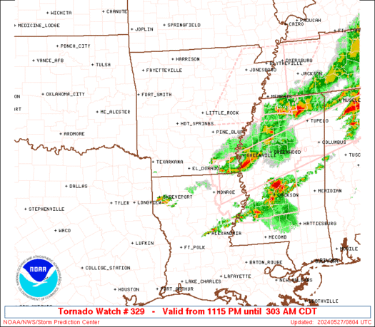
Tornado Watch Number 329
NWS Storm Prediction Center Norman OK
1115 PM CDT Sun May 26 2024
The NWS Storm Prediction Center has issued a
* Tornado Watch for portions of
Southern Arkansas
Northern Louisiana
Western Mississippi
Far Northeast Texas
* Effective this Sunday night and Monday morning from 1115 PM
until 500 AM CDT.
* Primary threats include...
A couple tornadoes possible
Scattered large hail and isolated very large hail events to 3
inches in diameter possible
Scattered damaging wind gusts to 70 mph possible
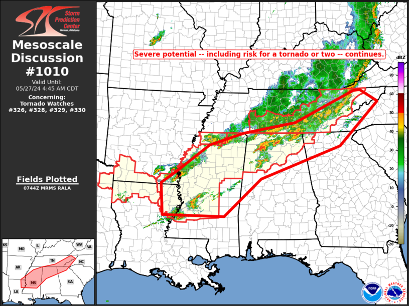
SUMMARY...Isolated to scattered severe thunderstorms will likely
continue to develop tonight. Several strong supercells will be
capable of a large to very large hail risk. A tornado risk could
also accompany any stronger and more persistent supercell as it
moves through a very moist and unstable airmass.
The tornado watch area is approximately along and 75 statute miles
east and west of a line from 25 miles northeast of Pine Bluff AR to
25 miles east of Shreveport LA. For a complete depiction of the
watch see the associated watch outline update (WOUS64 KWNS WOU9).
PRECAUTIONARY/PREPAREDNESS ACTIONS...
REMEMBER...A Tornado Watch means conditions are favorable for
tornadoes and severe thunderstorms in and close to the watch
area. Persons in these areas should be on the lookout for
threatening weather conditions and listen for later statements
and possible warnings.
&&
OTHER WATCH INFORMATION...CONTINUE...WW 324...WW 326...WW
327...WW 328...
AVIATION...Tornadoes and a few severe thunderstorms with hail
surface and aloft to 3 inches. Extreme turbulence and surface wind
gusts to 60 knots. A few cumulonimbi with maximum tops to 550. Mean
storm motion vector 26030.
...Smith
 Note:
The Aviation Watch (SAW) product is an approximation to the watch area.
The actual watch is depicted by the shaded areas.
Note:
The Aviation Watch (SAW) product is an approximation to the watch area.
The actual watch is depicted by the shaded areas.
   SAW9
   WW 329 TORNADO AR LA MS TX 270415Z - 271000Z
   AXIS..75 STATUTE MILES EAST AND WEST OF LINE..
   25NE PBF/PINE BLUFF AR/ - 25E SHV/SHREVEPORT LA/
   ..AVIATION COORDS.. 65NM E/W /32ESE LIT - 28SE EIC/
   HAIL SURFACE AND ALOFT..3 INCHES. WIND GUSTS..60 KNOTS.
   MAX TOPS TO 550. MEAN STORM MOTION VECTOR 26030.

   LAT...LON 34419030 32439212 32439469 34419294

   THIS IS AN APPROXIMATION TO THE WATCH AREA.  FOR A
   COMPLETE DEPICTION OF THE WATCH SEE WOUS64 KWNS
   FOR WOU9.
Watch 329 Status Report Messages:
STATUS REPORT #2 ON WW 329

VALID 270640Z - 270740Z

SEVERE WEATHER THREAT CONTINUES RIGHT OF A LINE FROM 40 SSW HOT
TO 45 N ELD TO 5 S PBF TO 30 NE PBF.

..GOSS..05/27/24

ATTN...WFO...LZK...JAN...SHV...

&&

STATUS REPORT FOR WT 329

SEVERE WEATHER THREAT CONTINUES FOR THE FOLLOWING AREAS

ARC001-011-013-025-027-041-043-057-069-073-079-091-099-103-139-
270740-

AR
.    ARKANSAS COUNTIES INCLUDED ARE

ARKANSAS	     BRADLEY		 CALHOUN
CLEVELAND	     COLUMBIA		 DESHA
DREW		     HEMPSTEAD		 JEFFERSON
LAFAYETTE	     LINCOLN		 MILLER
NEVADA		     OUACHITA		 UNION
$$


LAC015-017-027-061-073-111-119-270740-

LA
.    LOUISIANA PARISHES INCLUDED ARE

BOSSIER 	     CADDO		 CLAIBORNE
LINCOLN 	     OUACHITA		 UNION
WEBSTER
$$


TXC067-315-270740-

TX
.    TEXAS COUNTIES INCLUDED ARE

CASS		     MARION
$$


THE WATCH STATUS MESSAGE IS FOR GUIDANCE PURPOSES ONLY.  PLEASE
REFER TO WATCH COUNTY NOTIFICATION STATEMENTS FOR OFFICIAL
INFORMATION ON COUNTIES...INDEPENDENT CITIES AND MARINE ZONES
CLEARED FROM SEVERE THUNDERSTORM AND TORNADO WATCHES.
$$

STATUS REPORT #1 ON WW 329

VALID 270455Z - 270540Z

THE SEVERE WEATHER THREAT CONTINUES ACROSS THE ENTIRE WATCH AREA.

..MOSIER..05/27/24

ATTN...WFO...LZK...JAN...SHV...

&&

STATUS REPORT FOR WT 329

SEVERE WEATHER THREAT CONTINUES FOR THE FOLLOWING AREAS

ARC001-003-011-013-017-019-025-027-039-041-043-053-057-069-073-
079-091-099-103-139-270540-

AR
.    ARKANSAS COUNTIES INCLUDED ARE

ARKANSAS	     ASHLEY		 BRADLEY
CALHOUN 	     CHICOT		 CLARK
CLEVELAND	     COLUMBIA		 DALLAS
DESHA		     DREW		 GRANT
HEMPSTEAD	     JEFFERSON		 LAFAYETTE
LINCOLN 	     MILLER		 NEVADA
OUACHITA	     UNION
$$


LAC015-017-027-061-067-073-111-119-270540-

LA
.    LOUISIANA PARISHES INCLUDED ARE

BOSSIER 	     CADDO		 CLAIBORNE
LINCOLN 	     MOREHOUSE		 OUACHITA
UNION		     WEBSTER
$$


MSC011-270540-

MS
.    MISSISSIPPI COUNTIES INCLUDED ARE

BOLIVAR
$$


TXC067-315-270540-

TX
.    TEXAS COUNTIES INCLUDED ARE

CASS		     MARION
$$


THE WATCH STATUS MESSAGE IS FOR GUIDANCE PURPOSES ONLY.  PLEASE
REFER TO WATCH COUNTY NOTIFICATION STATEMENTS FOR OFFICIAL
INFORMATION ON COUNTIES...INDEPENDENT CITIES AND MARINE ZONES
CLEARED FROM SEVERE THUNDERSTORM AND TORNADO WATCHES.
$$
Note:
Click for Complete Product Text.
Tornadoes
Probability of 2 or more tornadoes
|
Mod (40%)
|
Probability of 1 or more strong (EF2-EF5) tornadoes
|
Low (20%)
|
Wind
Probability of 10 or more severe wind events
|
Mod (40%)
|
Probability of 1 or more wind events > 65 knots
|
Low (20%)
|
Hail
Probability of 10 or more severe hail events
|
Mod (40%)
|
Probability of 1 or more hailstones > 2 inches
|
Mod (40%)
|
Combined Severe Hail/Wind
Probability of 6 or more combined severe hail/wind events
|
High (70%)
|
For each watch, probabilities for particular events inside the watch
(listed above in each table) are determined by the issuing forecaster.
The "Low" category contains probability values ranging from less than 2%
to 20% (EF2-EF5 tornadoes), less than 5% to 20% (all other probabilities),
"Moderate" from 30% to 60%, and "High" from 70% to greater than 95%.
High values are bolded and lighter in color to provide awareness of
an increased threat for a particular event.


 @NWSSPC