 Note:
The expiration time in the watch graphic is amended if the watch is
replaced, cancelled or extended.
Note:
Note:
The expiration time in the watch graphic is amended if the watch is
replaced, cancelled or extended.
Note: Click for
Watch Status Reports.
SEL4
URGENT - IMMEDIATE BROADCAST REQUESTED
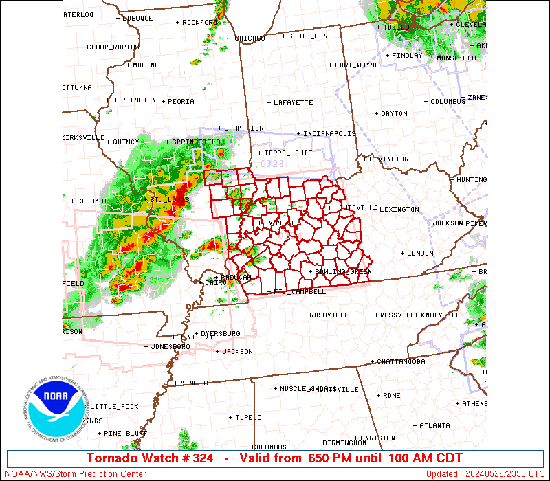
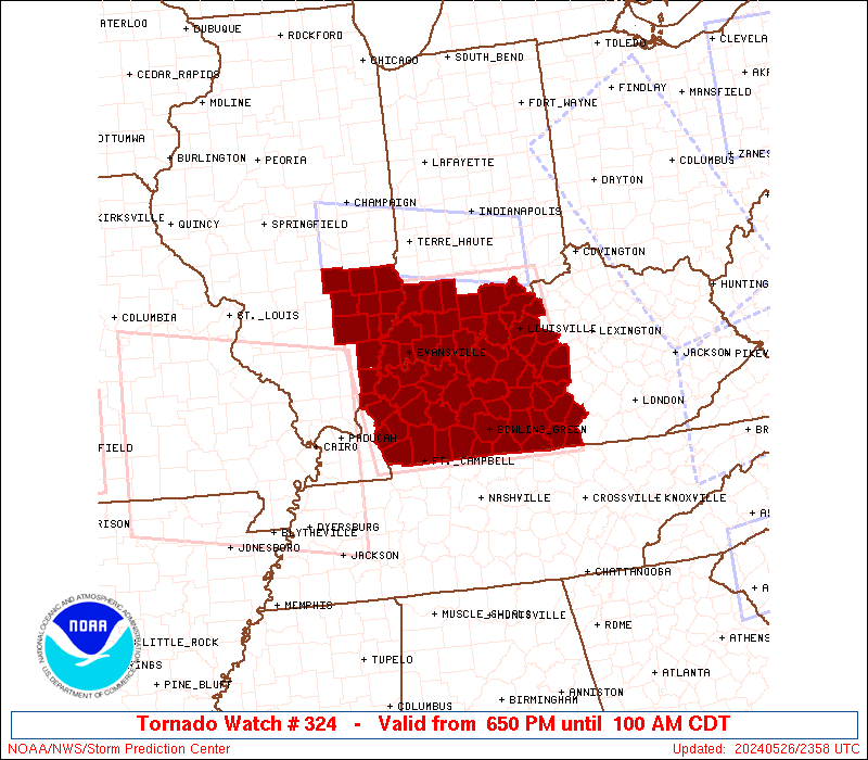
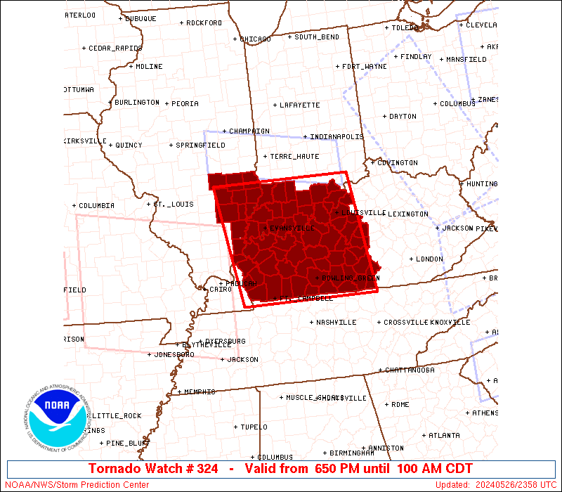
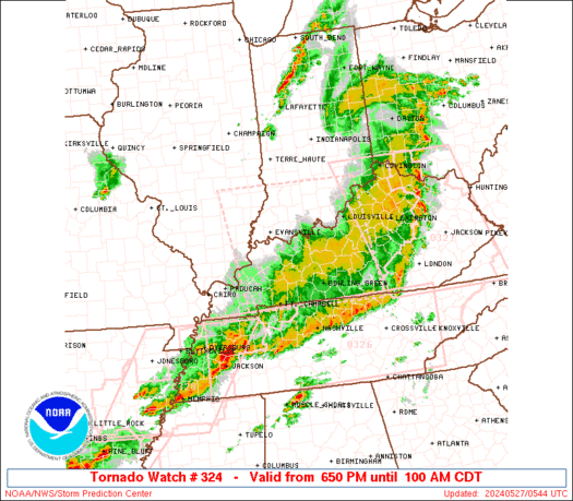
Tornado Watch Number 324
NWS Storm Prediction Center Norman OK
650 PM CDT Sun May 26 2024
The NWS Storm Prediction Center has issued a
* Tornado Watch for portions of
Southeast Illinois
Southern Indiana
Western and Central Kentucky
* Effective this Sunday night and Monday morning from 650 PM
until 100 AM CDT.
* Primary threats include...
Several tornadoes and a couple intense tornadoes likely
Widespread damaging winds and isolated significant gusts to 85
mph likely
Scattered large hail and isolated very large hail events to 3
inches in diameter likely
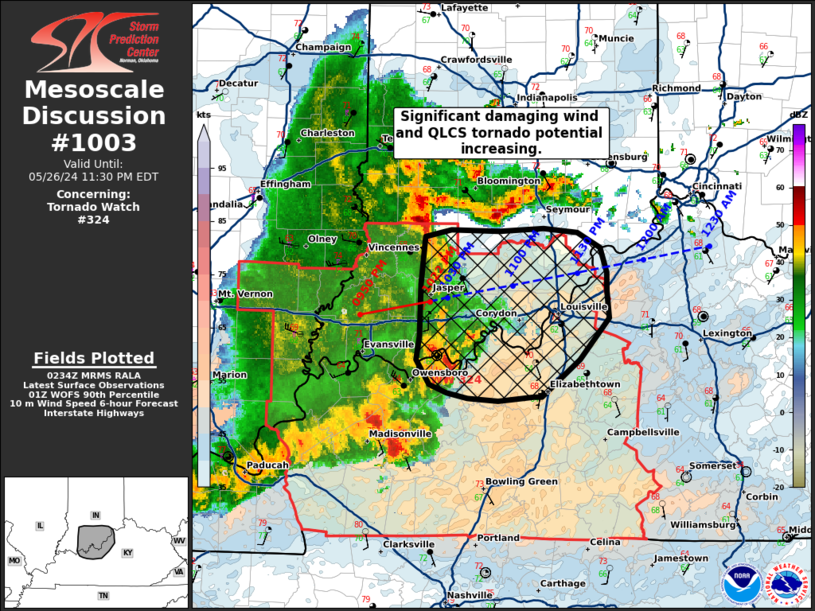
SUMMARY...Scattered supercells are forecast to move into the lower
Ohio Valley early this evening and pose a risk for tornadoes, some
potentially strong, and large to very large hail (up 2 to 3 inches
in diameter). Severe gusts are forecast to become more prevalent
later this evening as a severe squall line with embedded supercells
or mesovortices moves across the Watch area. A tornado risk will
probably accompany any stronger line-embedded circulations.
The tornado watch area is approximately along and 90 statute miles
east and west of a line from 70 miles north northeast of Evansville
IN to 30 miles south southwest of Bowling Green KY. For a complete
depiction of the watch see the associated watch outline update
(WOUS64 KWNS WOU4).
PRECAUTIONARY/PREPAREDNESS ACTIONS...
REMEMBER...A Tornado Watch means conditions are favorable for
tornadoes and severe thunderstorms in and close to the watch
area. Persons in these areas should be on the lookout for
threatening weather conditions and listen for later statements
and possible warnings.
&&
OTHER WATCH INFORMATION...CONTINUE...WW 316...WW 317...WW
318...WW 319...WW 320...WW 321...WW 322...WW 323...
AVIATION...Tornadoes and a few severe thunderstorms with hail
surface and aloft to 3 inches. Extreme turbulence and surface wind
gusts to 75 knots. A few cumulonimbi with maximum tops to 550. Mean
storm motion vector 24035.
...Smith

   SEL4

   URGENT - IMMEDIATE BROADCAST REQUESTED
   Tornado Watch Number 324
   NWS Storm Prediction Center Norman OK
   650 PM CDT Sun May 26 2024

   The NWS Storm Prediction Center has issued a

   * Tornado Watch for portions of
     Southeast Illinois
     Southern Indiana
     Western and Central Kentucky

   * Effective this Sunday night and Monday morning from 650 PM
     until 100 AM CDT.

   * Primary threats include...
     Several tornadoes and a couple intense tornadoes likely
     Widespread damaging winds and isolated significant gusts to 85
       mph likely
     Scattered large hail and isolated very large hail events to 3
       inches in diameter likely

   SUMMARY...Scattered supercells are forecast to move into the lower
   Ohio Valley early this evening and pose a risk for tornadoes, some
   potentially strong, and large to very large hail (up 2 to 3 inches
   in diameter).  Severe gusts are forecast to become more prevalent
   later this evening as a severe squall line with embedded supercells
   or mesovortices moves across the Watch area.  A tornado risk will
   probably accompany any stronger line-embedded circulations.

   The tornado watch area is approximately along and 90 statute miles
   east and west of a line from 70 miles north northeast of Evansville
   IN to 30 miles south southwest of Bowling Green KY. For a complete
   depiction of the watch see the associated watch outline update
   (WOUS64 KWNS WOU4).

   PRECAUTIONARY/PREPAREDNESS ACTIONS...

   REMEMBER...A Tornado Watch means conditions are favorable for
   tornadoes and severe thunderstorms in and close to the watch
   area. Persons in these areas should be on the lookout for
   threatening weather conditions and listen for later statements
   and possible warnings.

   &&

   OTHER WATCH INFORMATION...CONTINUE...WW 316...WW 317...WW
   318...WW 319...WW 320...WW 321...WW 322...WW 323...

   AVIATION...Tornadoes and a few severe thunderstorms with hail
   surface and aloft to 3 inches. Extreme turbulence and surface wind
   gusts to 75 knots. A few cumulonimbi with maximum tops to 550. Mean
   storm motion vector 24035.

   ...Smith
 Note:
The Aviation Watch (SAW) product is an approximation to the watch area.
The actual watch is depicted by the shaded areas.
Note:
The Aviation Watch (SAW) product is an approximation to the watch area.
The actual watch is depicted by the shaded areas.
   SAW4
   WW 324 TORNADO IL IN KY 262350Z - 270600Z
   AXIS..90 STATUTE MILES EAST AND WEST OF LINE..
   70NNE EVV/EVANSVILLE IN/ - 30SSW BWG/BOWLING GREEN KY/
   ..AVIATION COORDS.. 80NM E/W /33SSE TTH - 23SSW BWG/
   HAIL SURFACE AND ALOFT..3 INCHES. WIND GUSTS..75 KNOTS.
   MAX TOPS TO 550. MEAN STORM MOTION VECTOR 24035.

   LAT...LON 38958536 36568501 36568825 38958871

   THIS IS AN APPROXIMATION TO THE WATCH AREA.  FOR A
   COMPLETE DEPICTION OF THE WATCH SEE WOUS64 KWNS
   FOR WOU4.
Watch 324 Status Report Messages:
STATUS REPORT #5 ON WW 324

VALID 270450Z - 270540Z

SEVERE WEATHER THREAT CONTINUES RIGHT OF A LINE FROM CKV TO 30 E
BWG TO 40 SW LEX.

..MOSIER..05/27/24

ATTN...WFO...ILX...PAH...LMK...IND...

&&

STATUS REPORT FOR WT 324

SEVERE WEATHER THREAT CONTINUES FOR THE FOLLOWING AREAS

KYC001-003-053-057-155-169-171-207-213-270540-

KY
.    KENTUCKY COUNTIES INCLUDED ARE

ADAIR		     ALLEN		 CLINTON
CUMBERLAND	     MARION		 METCALFE
MONROE		     RUSSELL		 SIMPSON
$$


THE WATCH STATUS MESSAGE IS FOR GUIDANCE PURPOSES ONLY.  PLEASE
REFER TO WATCH COUNTY NOTIFICATION STATEMENTS FOR OFFICIAL
INFORMATION ON COUNTIES...INDEPENDENT CITIES AND MARINE ZONES
CLEARED FROM SEVERE THUNDERSTORM AND TORNADO WATCHES.
$$

STATUS REPORT #4 ON WW 324

VALID 270355Z - 270440Z

SEVERE WEATHER THREAT CONTINUES RIGHT OF A LINE FROM 20 S PAH TO
35 S OWB TO 35 ESE OWB TO 20 W SDF TO 30 ESE IND.

..LYONS..05/27/24

ATTN...WFO...ILX...PAH...LMK...IND...

&&

STATUS REPORT FOR WT 324

SEVERE WEATHER THREAT CONTINUES FOR THE FOLLOWING AREAS

KYC001-003-009-029-031-047-053-057-061-085-087-093-099-111-123-
141-155-169-171-179-207-213-215-217-219-221-227-229-270440-

KY
.    KENTUCKY COUNTIES INCLUDED ARE

ADAIR		     ALLEN		 BARREN
BULLITT 	     BUTLER		 CHRISTIAN
CLINTON 	     CUMBERLAND 	 EDMONSON
GRAYSON 	     GREEN		 HARDIN
HART		     JEFFERSON		 LARUE
LOGAN		     MARION		 METCALFE
MONROE		     NELSON		 RUSSELL
SIMPSON 	     SPENCER		 TAYLOR
TODD		     TRIGG		 WARREN
WASHINGTON
$$


THE WATCH STATUS MESSAGE IS FOR GUIDANCE PURPOSES ONLY.  PLEASE
REFER TO WATCH COUNTY NOTIFICATION STATEMENTS FOR OFFICIAL
INFORMATION ON COUNTIES...INDEPENDENT CITIES AND MARINE ZONES
CLEARED FROM SEVERE THUNDERSTORM AND TORNADO WATCHES.
$$

STATUS REPORT #3 ON WW 324

VALID 270250Z - 270340Z

SEVERE WEATHER THREAT CONTINUES RIGHT OF A LINE FROM 20 NE PAH TO
20 S EVV TO 15 E EVV TO 35 NE EVV TO 35 SW BMG TO 10 SSE HUF.

..LYONS..05/27/24

ATTN...WFO...ILX...PAH...LMK...IND...

&&

STATUS REPORT FOR WT 324

SEVERE WEATHER THREAT CONTINUES FOR THE FOLLOWING AREAS

INC019-025-027-037-043-061-101-117-123-143-147-173-175-270340-

IN
.    INDIANA COUNTIES INCLUDED ARE

CLARK		     CRAWFORD		 DAVIESS
DUBOIS		     FLOYD		 HARRISON
MARTIN		     ORANGE		 PERRY
SCOTT		     SPENCER		 WARRICK
WASHINGTON
$$


KYC001-003-009-027-029-031-033-047-053-055-057-059-061-085-087-
091-093-099-101-107-111-123-141-143-149-155-163-169-171-177-179-
183-185-207-213-215-217-219-221-227-229-233-270340-

KY
.    KENTUCKY COUNTIES INCLUDED ARE

ADAIR		     ALLEN		 BARREN
BRECKINRIDGE	     BULLITT		 BUTLER
CALDWELL	     CHRISTIAN		 CLINTON
CRITTENDEN	     CUMBERLAND 	 DAVIESS
EDMONSON	     GRAYSON		 GREEN
HANCOCK 	     HARDIN		 HART
HENDERSON	     HOPKINS		 JEFFERSON
LARUE		     LOGAN		 LYON
MCLEAN		     MARION		 MEADE
METCALFE	     MONROE		 MUHLENBERG
NELSON		     OHIO		 OLDHAM
RUSSELL 	     SIMPSON		 SPENCER
TAYLOR		     TODD		 TRIGG
WARREN		     WASHINGTON 	 WEBSTER
$$


THE WATCH STATUS MESSAGE IS FOR GUIDANCE PURPOSES ONLY.  PLEASE
REFER TO WATCH COUNTY NOTIFICATION STATEMENTS FOR OFFICIAL
INFORMATION ON COUNTIES...INDEPENDENT CITIES AND MARINE ZONES
CLEARED FROM SEVERE THUNDERSTORM AND TORNADO WATCHES.
$$

STATUS REPORT #2 ON WW 324

VALID 270120Z - 270240Z

THE SEVERE WEATHER THREAT CONTINUES ACROSS THE ENTIRE WATCH AREA.

..LYONS..05/27/24

ATTN...WFO...ILX...PAH...LMK...IND...

&&

STATUS REPORT FOR WT 324

SEVERE WEATHER THREAT CONTINUES FOR THE FOLLOWING AREAS

ILC025-033-047-049-059-069-079-101-159-185-191-193-270240-

IL
.    ILLINOIS COUNTIES INCLUDED ARE

CLAY		     CRAWFORD		 EDWARDS
EFFINGHAM	     GALLATIN		 HARDIN
JASPER		     LAWRENCE		 RICHLAND
WABASH		     WAYNE		 WHITE
$$


INC019-025-027-037-043-051-061-083-101-117-123-125-129-143-147-
163-173-175-270240-

IN
.    INDIANA COUNTIES INCLUDED ARE

CLARK		     CRAWFORD		 DAVIESS
DUBOIS		     FLOYD		 GIBSON
HARRISON	     KNOX		 MARTIN
ORANGE		     PERRY		 PIKE
POSEY		     SCOTT		 SPENCER
VANDERBURGH	     WARRICK		 WASHINGTON
$$


KYC001-003-009-027-029-031-033-047-053-055-057-059-061-085-087-
091-093-099-101-107-111-123-141-143-149-155-163-169-171-177-179-
183-185-207-213-215-217-219-221-225-227-229-233-270240-

KY
.    KENTUCKY COUNTIES INCLUDED ARE

ADAIR		     ALLEN		 BARREN
BRECKINRIDGE	     BULLITT		 BUTLER
CALDWELL	     CHRISTIAN		 CLINTON
CRITTENDEN	     CUMBERLAND 	 DAVIESS
EDMONSON	     GRAYSON		 GREEN
HANCOCK 	     HARDIN		 HART
HENDERSON	     HOPKINS		 JEFFERSON
LARUE		     LOGAN		 LYON
MCLEAN		     MARION		 MEADE
METCALFE	     MONROE		 MUHLENBERG
NELSON		     OHIO		 OLDHAM
RUSSELL 	     SIMPSON		 SPENCER
TAYLOR		     TODD		 TRIGG
UNION		     WARREN		 WASHINGTON
WEBSTER
$$


THE WATCH STATUS MESSAGE IS FOR GUIDANCE PURPOSES ONLY.  PLEASE
REFER TO WATCH COUNTY NOTIFICATION STATEMENTS FOR OFFICIAL
INFORMATION ON COUNTIES...INDEPENDENT CITIES AND MARINE ZONES
CLEARED FROM SEVERE THUNDERSTORM AND TORNADO WATCHES.
$$

STATUS REPORT #1 ON WW 324

VALID 270020Z - 270140Z

THE SEVERE WEATHER THREAT CONTINUES ACROSS THE ENTIRE WATCH AREA.

..LYONS..05/27/24

ATTN...WFO...ILX...PAH...LMK...IND...

&&

STATUS REPORT FOR WT 324

SEVERE WEATHER THREAT CONTINUES FOR THE FOLLOWING AREAS

ILC025-033-047-049-059-069-079-101-159-185-191-193-270140-

IL
.    ILLINOIS COUNTIES INCLUDED ARE

CLAY		     CRAWFORD		 EDWARDS
EFFINGHAM	     GALLATIN		 HARDIN
JASPER		     LAWRENCE		 RICHLAND
WABASH		     WAYNE		 WHITE
$$


INC019-025-027-037-043-051-061-083-101-117-123-125-129-143-147-
163-173-175-270140-

IN
.    INDIANA COUNTIES INCLUDED ARE

CLARK		     CRAWFORD		 DAVIESS
DUBOIS		     FLOYD		 GIBSON
HARRISON	     KNOX		 MARTIN
ORANGE		     PERRY		 PIKE
POSEY		     SCOTT		 SPENCER
VANDERBURGH	     WARRICK		 WASHINGTON
$$


KYC001-003-009-027-029-031-033-047-053-055-057-059-061-085-087-
091-093-099-101-107-111-123-141-143-149-155-163-169-171-177-179-
183-185-207-213-215-217-219-221-225-227-229-233-270140-

KY
.    KENTUCKY COUNTIES INCLUDED ARE

ADAIR		     ALLEN		 BARREN
BRECKINRIDGE	     BULLITT		 BUTLER
CALDWELL	     CHRISTIAN		 CLINTON
CRITTENDEN	     CUMBERLAND 	 DAVIESS
EDMONSON	     GRAYSON		 GREEN
HANCOCK 	     HARDIN		 HART
HENDERSON	     HOPKINS		 JEFFERSON
LARUE		     LOGAN		 LYON
MCLEAN		     MARION		 MEADE
METCALFE	     MONROE		 MUHLENBERG
NELSON		     OHIO		 OLDHAM
RUSSELL 	     SIMPSON		 SPENCER
TAYLOR		     TODD		 TRIGG
UNION		     WARREN		 WASHINGTON
WEBSTER
$$


THE WATCH STATUS MESSAGE IS FOR GUIDANCE PURPOSES ONLY.  PLEASE
REFER TO WATCH COUNTY NOTIFICATION STATEMENTS FOR OFFICIAL
INFORMATION ON COUNTIES...INDEPENDENT CITIES AND MARINE ZONES
CLEARED FROM SEVERE THUNDERSTORM AND TORNADO WATCHES.
$$
Note:
Click for Complete Product Text.
Tornadoes
Probability of 2 or more tornadoes
|
High (80%)
|
Probability of 1 or more strong (EF2-EF5) tornadoes
|
Mod (60%)
|
Wind
Probability of 10 or more severe wind events
|
High (90%)
|
Probability of 1 or more wind events > 65 knots
|
High (70%)
|
Hail
Probability of 10 or more severe hail events
|
Mod (60%)
|
Probability of 1 or more hailstones > 2 inches
|
Mod (60%)
|
Combined Severe Hail/Wind
Probability of 6 or more combined severe hail/wind events
|
High (>95%)
|
For each watch, probabilities for particular events inside the watch
(listed above in each table) are determined by the issuing forecaster.
The "Low" category contains probability values ranging from less than 2%
to 20% (EF2-EF5 tornadoes), less than 5% to 20% (all other probabilities),
"Moderate" from 30% to 60%, and "High" from 70% to greater than 95%.
High values are bolded and lighter in color to provide awareness of
an increased threat for a particular event.


 @NWSSPC