Note:
The expiration time in the watch graphic is amended if the watch is
replaced, cancelled or extended.
Note:
Note:
The expiration time in the watch graphic is amended if the watch is
replaced, cancelled or extended.
Note: Click for
Watch Status Reports.
SEL5
URGENT - IMMEDIATE BROADCAST REQUESTED
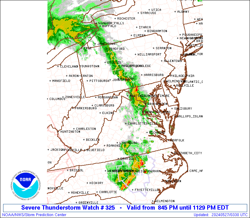
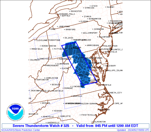
Severe Thunderstorm Watch Number 325
NWS Storm Prediction Center Norman OK
845 PM EDT Sun May 26 2024
The NWS Storm Prediction Center has issued a
* Severe Thunderstorm Watch for portions of
District Of Columbia
Western and Central Maryland
South-Central Pennsylvania
Central and Northern Virginia
Eastern West Virginia Panhandle
Coastal Waters
* Effective this Sunday night from 845 PM until Midnight EDT.
* Primary threats include...
Scattered damaging wind gusts to 65 mph possible
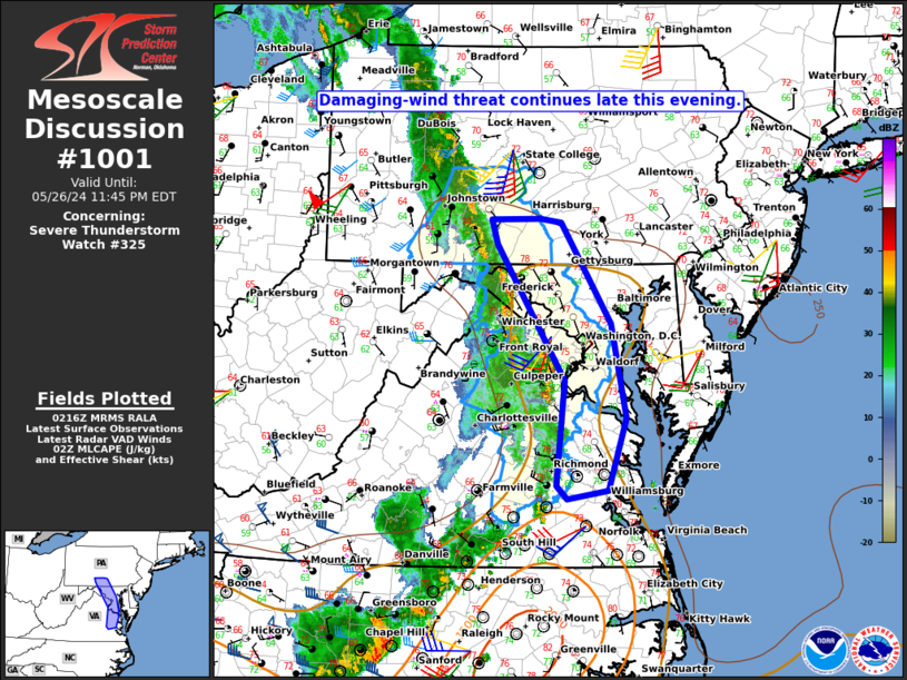
SUMMARY...A mature squall line will continue to move northeast
across the Watch area during the mid to late evening. The stronger
embedded cells within the line and bowing segments will be capable
of strong to severe gusts (55-65 mph) and wind damage.
The severe thunderstorm watch area is approximately along and 40
statute miles east and west of a line from 25 miles north northwest
of Altoona PA to 20 miles south of Richmond VA. For a complete
depiction of the watch see the associated watch outline update
(WOUS64 KWNS WOU5).
PRECAUTIONARY/PREPAREDNESS ACTIONS...
REMEMBER...A Severe Thunderstorm Watch means conditions are
favorable for severe thunderstorms in and close to the watch area.
Persons in these areas should be on the lookout for threatening
weather conditions and listen for later statements and possible
warnings. Severe thunderstorms can and occasionally do produce
tornadoes.
&&
OTHER WATCH INFORMATION...CONTINUE...WW 317...WW 318...WW
319...WW 320...WW 321...WW 322...WW 323...WW 324...
AVIATION...A few severe thunderstorms with hail surface and aloft to
1 inch. Extreme turbulence and surface wind gusts to 55 knots. A few
cumulonimbi with maximum tops to 450. Mean storm motion vector
23035.
...Smith
 Note:
The Aviation Watch (SAW) product is an approximation to the watch area.
The actual watch is depicted by the shaded areas.
Note:
The Aviation Watch (SAW) product is an approximation to the watch area.
The actual watch is depicted by the shaded areas.
SAW5
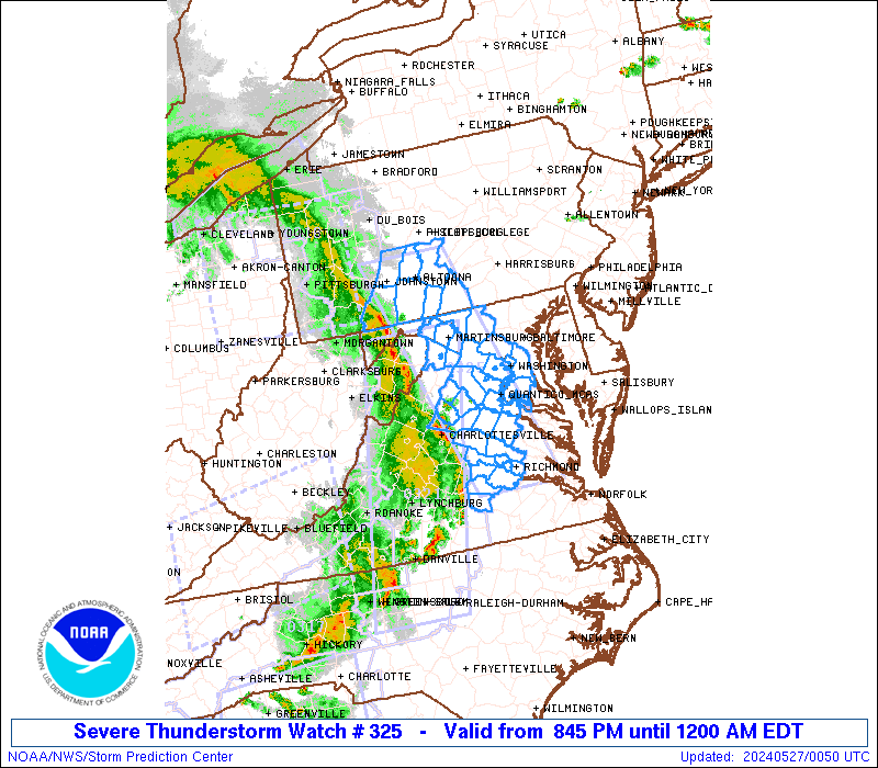
WW 325 SEVERE TSTM DC MD PA VA WV CW 270045Z - 270400Z
AXIS..40 STATUTE MILES EAST AND WEST OF LINE..
25NNW AOO/ALTOONA PA/ - 20S RIC/RICHMOND VA/
..AVIATION COORDS.. 35NM E/W /24NE JST - 17S RIC/
HAIL SURFACE AND ALOFT..1 INCH. WIND GUSTS..55 KNOTS.
MAX TOPS TO 450. MEAN STORM MOTION VECTOR 23035.
LAT...LON 40627773 37217658 37217804 40627926
THIS IS AN APPROXIMATION TO THE WATCH AREA. FOR A
COMPLETE DEPICTION OF THE WATCH SEE WOUS64 KWNS
FOR WOU5.
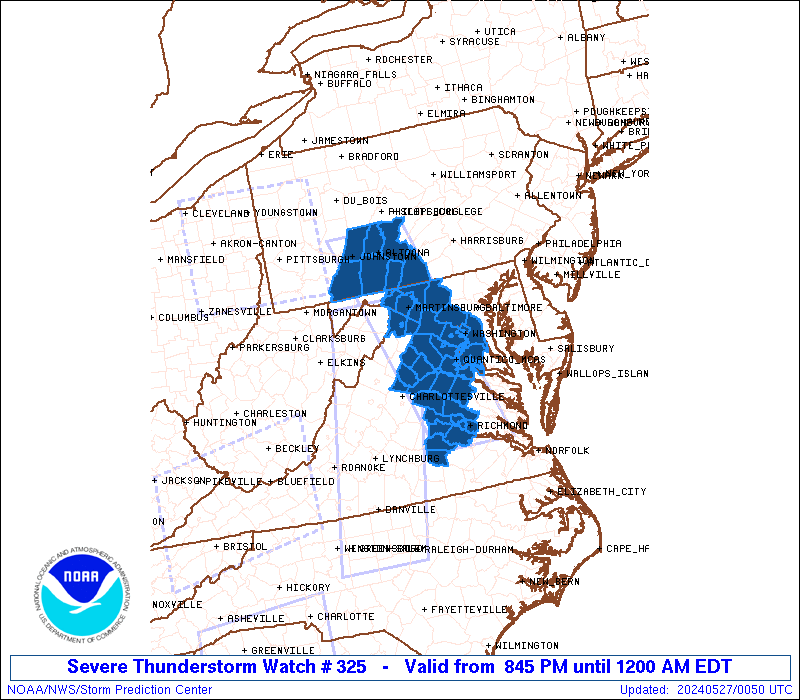
Watch 325 Status Report Messages:
STATUS REPORT #1 ON WW 325

VALID 270250Z - 270340Z

SEVERE WEATHER THREAT CONTINUES RIGHT OF A LINE FROM 35 NNE RIC
TO 5 W MRB TO 30 NE LBE.

..LYONS..05/27/24

ATTN...WFO...LWX...CTP...AKQ...

&&

STATUS REPORT FOR WS 325

SEVERE WEATHER THREAT CONTINUES FOR THE FOLLOWING AREAS

DCC001-270340-

DC
.    DISTRICT OF COLUMBIA COUNTIES INCLUDED ARE

DISTRICT OF COLUMBIA
$$


MDC017-021-031-033-043-270340-

MD
.    MARYLAND COUNTIES INCLUDED ARE

CHARLES 	     FREDERICK		 MONTGOMERY
PRINCE GEORGES	     WASHINGTON
$$


PAC009-013-021-055-057-061-270340-

PA
.    PENNSYLVANIA COUNTIES INCLUDED ARE

BEDFORD 	     BLAIR		 CAMBRIA
FRANKLIN	     FULTON		 HUNTINGDON
$$


VAC013-059-107-153-510-600-610-683-685-270340-

VA
.    VIRGINIA COUNTIES INCLUDED ARE

ARLINGTON	     FAIRFAX		 LOUDOUN
PRINCE WILLIAM


VIRGINIA INDEPENDENT CITIES INCLUDED ARE

ALEXANDRIA	     FAIRFAX		 FALLS CHURCH
MANASSAS	     MANASSAS PARK
$$


WVC037-270340-

WV
.    WEST VIRGINIA COUNTIES INCLUDED ARE

JEFFERSON
$$


ANZ535-270340-

CW

.    ADJACENT COASTAL WATERS INCLUDED ARE

TIDAL POTOMAC FROM KEY BRIDGE TO INDIAN HEAD MD

$$
THE WATCH STATUS MESSAGE IS FOR GUIDANCE PURPOSES ONLY.  PLEASE
REFER TO WATCH COUNTY NOTIFICATION STATEMENTS FOR OFFICIAL
INFORMATION ON COUNTIES...INDEPENDENT CITIES AND MARINE ZONES
CLEARED FROM SEVERE THUNDERSTORM AND TORNADO WATCHES.
$$
Note:
Click for Complete Product Text.
Tornadoes
Probability of 2 or more tornadoes
|
Low (<5%)
|
Probability of 1 or more strong (EF2-EF5) tornadoes
|
Low (<2%)
|
Wind
Probability of 10 or more severe wind events
|
Mod (50%)
|
Probability of 1 or more wind events > 65 knots
|
Low (10%)
|
Hail
Probability of 10 or more severe hail events
|
Low (<5%)
|
Probability of 1 or more hailstones > 2 inches
|
Low (<5%)
|
Combined Severe Hail/Wind
Probability of 6 or more combined severe hail/wind events
|
High (70%)
|
For each watch, probabilities for particular events inside the watch
(listed above in each table) are determined by the issuing forecaster.
The "Low" category contains probability values ranging from less than 2%
to 20% (EF2-EF5 tornadoes), less than 5% to 20% (all other probabilities),
"Moderate" from 30% to 60%, and "High" from 70% to greater than 95%.
High values are bolded and lighter in color to provide awareness of
an increased threat for a particular event.


 @NWSSPC