 Note:
The expiration time in the watch graphic is amended if the watch is
replaced, cancelled or extended.
Note:
Note:
The expiration time in the watch graphic is amended if the watch is
replaced, cancelled or extended.
Note: Click for
Watch Status Reports.
SEL7
URGENT - IMMEDIATE BROADCAST REQUESTED
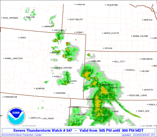
Severe Thunderstorm Watch Number 347
NWS Storm Prediction Center Norman OK
505 PM MDT Tue May 28 2024
The NWS Storm Prediction Center has issued a
* Severe Thunderstorm Watch for portions of
Eastern Colorado
Western Kansas
* Effective this Tuesday afternoon and evening from 505 PM until
900 PM MDT.
* Primary threats include...
Isolated very large hail events to 2 inches in diameter possible
Isolated damaging wind gusts to 70 mph possible
SUMMARY...Scattered thunderstorms will continue to develop and
intensify this afternoon into the evening. Large hail and localized
severe gusts will be the primary risks with the stronger
thunderstorms.
The severe thunderstorm watch area is approximately along and 40
statute miles north and south of a line from 55 miles west southwest
of Burlington CO to 40 miles southeast of Goodland KS. For a
complete depiction of the watch see the associated watch outline
update (WOUS64 KWNS WOU7).
PRECAUTIONARY/PREPAREDNESS ACTIONS...
REMEMBER...A Severe Thunderstorm Watch means conditions are
favorable for severe thunderstorms in and close to the watch area.
Persons in these areas should be on the lookout for threatening
weather conditions and listen for later statements and possible
warnings. Severe thunderstorms can and occasionally do produce
tornadoes.
&&
OTHER WATCH INFORMATION...CONTINUE...WW 344...WW 345...WW 346...
AVIATION...A few severe thunderstorms with hail surface and aloft to
2 inches. Extreme turbulence and surface wind gusts to 60 knots. A
few cumulonimbi with maximum tops to 500. Mean storm motion vector
27015.
...Smith
 Note:
The Aviation Watch (SAW) product is an approximation to the watch area.
The actual watch is depicted by the shaded areas.
Note:
The Aviation Watch (SAW) product is an approximation to the watch area.
The actual watch is depicted by the shaded areas.
   SAW7
   WW 347 SEVERE TSTM CO KS 282305Z - 290300Z
   AXIS..40 STATUTE MILES NORTH AND SOUTH OF LINE..
   55WSW ITR/BURLINGTON CO/ - 40SE GLD/GOODLAND KS/
   ..AVIATION COORDS.. 35NM N/S /51NNW LAA - 36SE GLD/
   HAIL SURFACE AND ALOFT..2 INCHES. WIND GUSTS..60 KNOTS.
   MAX TOPS TO 500. MEAN STORM MOTION VECTOR 27015.

   LAT...LON 39500323 39530117 38370117 38340323

   THIS IS AN APPROXIMATION TO THE WATCH AREA.  FOR A
   COMPLETE DEPICTION OF THE WATCH SEE WOUS64 KWNS
   FOR WOU7.
Watch 347 Status Report Messages:
STATUS REPORT #3 ON WW 347

VALID 290130Z - 290240Z

SEVERE WEATHER THREAT CONTINUES RIGHT OF A LINE FROM 10 NNE LAA
TO 25 S ITR TO 40 SSE AKO.

..MOORE..05/29/24

ATTN...WFO...GLD...

&&

STATUS REPORT FOR WS 347

SEVERE WEATHER THREAT CONTINUES FOR THE FOLLOWING AREAS

COC063-290240-

CO
.    COLORADO COUNTIES INCLUDED ARE

KIT CARSON
$$


KSC071-181-199-203-290240-

KS
.    KANSAS COUNTIES INCLUDED ARE

GREELEY 	     SHERMAN		 WALLACE
WICHITA
$$


THE WATCH STATUS MESSAGE IS FOR GUIDANCE PURPOSES ONLY.  PLEASE
REFER TO WATCH COUNTY NOTIFICATION STATEMENTS FOR OFFICIAL
INFORMATION ON COUNTIES...INDEPENDENT CITIES AND MARINE ZONES
CLEARED FROM SEVERE THUNDERSTORM AND TORNADO WATCHES.
$$

STATUS REPORT #2 ON WW 347

VALID 290040Z - 290140Z

THE SEVERE WEATHER THREAT CONTINUES ACROSS THE ENTIRE WATCH AREA.

..BROYLES..05/29/24

ATTN...WFO...GLD...

&&

STATUS REPORT FOR WS 347

SEVERE WEATHER THREAT CONTINUES FOR THE FOLLOWING AREAS

COC017-063-290140-

CO
.    COLORADO COUNTIES INCLUDED ARE

CHEYENNE	     KIT CARSON
$$


KSC071-181-199-203-290140-

KS
.    KANSAS COUNTIES INCLUDED ARE

GREELEY 	     SHERMAN		 WALLACE
WICHITA
$$


THE WATCH STATUS MESSAGE IS FOR GUIDANCE PURPOSES ONLY.  PLEASE
REFER TO WATCH COUNTY NOTIFICATION STATEMENTS FOR OFFICIAL
INFORMATION ON COUNTIES...INDEPENDENT CITIES AND MARINE ZONES
CLEARED FROM SEVERE THUNDERSTORM AND TORNADO WATCHES.
$$

STATUS REPORT #1 ON WW 347

VALID 282345Z - 290040Z

THE SEVERE WEATHER THREAT CONTINUES ACROSS THE ENTIRE WATCH AREA.

..BROYLES..05/28/24

ATTN...WFO...GLD...

&&

STATUS REPORT FOR WS 347

SEVERE WEATHER THREAT CONTINUES FOR THE FOLLOWING AREAS

COC017-063-290040-

CO
.    COLORADO COUNTIES INCLUDED ARE

CHEYENNE	     KIT CARSON
$$


KSC071-181-199-203-290040-

KS
.    KANSAS COUNTIES INCLUDED ARE

GREELEY 	     SHERMAN		 WALLACE
WICHITA
$$


THE WATCH STATUS MESSAGE IS FOR GUIDANCE PURPOSES ONLY.  PLEASE
REFER TO WATCH COUNTY NOTIFICATION STATEMENTS FOR OFFICIAL
INFORMATION ON COUNTIES...INDEPENDENT CITIES AND MARINE ZONES
CLEARED FROM SEVERE THUNDERSTORM AND TORNADO WATCHES.
$$
Note:
Click for Complete Product Text.
Tornadoes
Probability of 2 or more tornadoes
|
Low (<5%)
|
Probability of 1 or more strong (EF2-EF5) tornadoes
|
Low (<2%)
|
Wind
Probability of 10 or more severe wind events
|
Mod (30%)
|
Probability of 1 or more wind events > 65 knots
|
Low (20%)
|
Hail
Probability of 10 or more severe hail events
|
Mod (30%)
|
Probability of 1 or more hailstones > 2 inches
|
Mod (30%)
|
Combined Severe Hail/Wind
Probability of 6 or more combined severe hail/wind events
|
Mod (60%)
|
For each watch, probabilities for particular events inside the watch
(listed above in each table) are determined by the issuing forecaster.
The "Low" category contains probability values ranging from less than 2%
to 20% (EF2-EF5 tornadoes), less than 5% to 20% (all other probabilities),
"Moderate" from 30% to 60%, and "High" from 70% to greater than 95%.
High values are bolded and lighter in color to provide awareness of
an increased threat for a particular event.


 @NWSSPC


