Note:
The expiration time in the watch graphic is amended if the watch is
replaced, cancelled or extended.
Note:
Note:
The expiration time in the watch graphic is amended if the watch is
replaced, cancelled or extended.
Note: Click for
Watch Status Reports.
SEL4
URGENT - IMMEDIATE BROADCAST REQUESTED
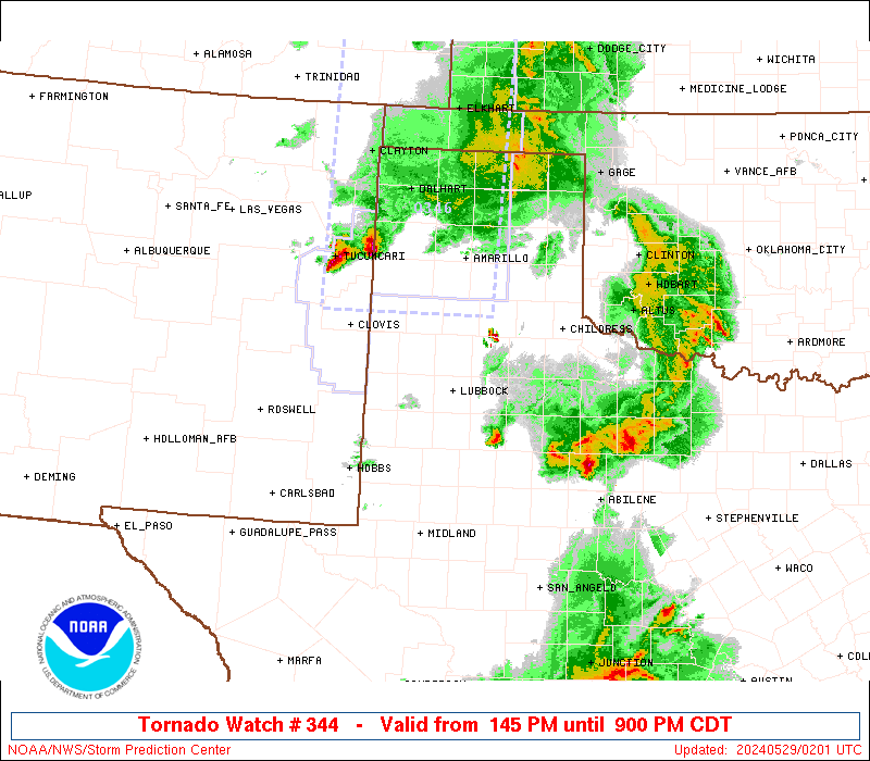
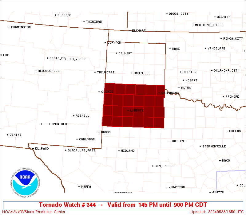
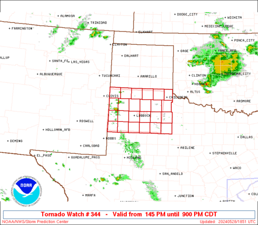
Tornado Watch Number 344
NWS Storm Prediction Center Norman OK
145 PM CDT Tue May 28 2024
The NWS Storm Prediction Center has issued a
* Tornado Watch for portions of
West Texas
* Effective this Tuesday afternoon and evening from 145 PM until
900 PM CDT.
* Primary threats include...
A few tornadoes possible
Scattered damaging winds and isolated significant gusts to 75
mph likely
Scattered large hail and isolated very large hail events to 3
inches in diameter likely
SUMMARY...Thunderstorms are rapidly developing along a boundary near
the TX/NM border. These storms will spread eastward through the
afternoon, posing a risk of very large hail and tornadoes.
The tornado watch area is approximately along and 75 statute miles
east and west of a line from 35 miles north of Plainview TX to 45
miles south of Lubbock TX. For a complete depiction of the watch see
the associated watch outline update (WOUS64 KWNS WOU4).
PRECAUTIONARY/PREPAREDNESS ACTIONS...
REMEMBER...A Tornado Watch means conditions are favorable for
tornadoes and severe thunderstorms in and close to the watch
area. Persons in these areas should be on the lookout for
threatening weather conditions and listen for later statements
and possible warnings.
&&
OTHER WATCH INFORMATION...CONTINUE...WW 342...WW 343...
AVIATION...Tornadoes and a few severe thunderstorms with hail
surface and aloft to 3 inches. Extreme turbulence and surface wind
gusts to 65 knots. A few cumulonimbi with maximum tops to 500. Mean
storm motion vector 27025.
...Hart
   SEL4

   URGENT - IMMEDIATE BROADCAST REQUESTED
   Tornado Watch Number 344
   NWS Storm Prediction Center Norman OK
   145 PM CDT Tue May 28 2024

   The NWS Storm Prediction Center has issued a

   * Tornado Watch for portions of
     West Texas

   * Effective this Tuesday afternoon and evening from 145 PM until
     900 PM CDT.

   * Primary threats include...
     A few tornadoes possible
     Scattered damaging winds and isolated significant gusts to 75
       mph likely
     Scattered large hail and isolated very large hail events to 3
       inches in diameter likely

   SUMMARY...Thunderstorms are rapidly developing along a boundary near
   the TX/NM border.  These storms will spread eastward through the
   afternoon, posing a risk of very large hail and tornadoes.

   The tornado watch area is approximately along and 75 statute miles
   east and west of a line from 35 miles north of Plainview TX to 45
   miles south of Lubbock TX. For a complete depiction of the watch see
   the associated watch outline update (WOUS64 KWNS WOU4).

   PRECAUTIONARY/PREPAREDNESS ACTIONS...

   REMEMBER...A Tornado Watch means conditions are favorable for
   tornadoes and severe thunderstorms in and close to the watch
   area. Persons in these areas should be on the lookout for
   threatening weather conditions and listen for later statements
   and possible warnings.

   &&

   OTHER WATCH INFORMATION...CONTINUE...WW 342...WW 343...

   AVIATION...Tornadoes and a few severe thunderstorms with hail
   surface and aloft to 3 inches. Extreme turbulence and surface wind
   gusts to 65 knots. A few cumulonimbi with maximum tops to 500. Mean
   storm motion vector 27025.

   ...Hart
 Note:
The Aviation Watch (SAW) product is an approximation to the watch area.
The actual watch is depicted by the shaded areas.
Note:
The Aviation Watch (SAW) product is an approximation to the watch area.
The actual watch is depicted by the shaded areas.
   SAW4
   WW 344 TORNADO TX 281845Z - 290200Z
   AXIS..75 STATUTE MILES EAST AND WEST OF LINE..
   35N PVW/PLAINVIEW TX/ - 45S LBB/LUBBOCK TX/
   ..AVIATION COORDS.. 65NM E/W /37S AMA - 41S LBB/
   HAIL SURFACE AND ALOFT..3 INCHES. WIND GUSTS..65 KNOTS.
   MAX TOPS TO 500. MEAN STORM MOTION VECTOR 27025.

   LAT...LON 34660040 33000053 33000311 34660304

   THIS IS AN APPROXIMATION TO THE WATCH AREA.  FOR A
   COMPLETE DEPICTION OF THE WATCH SEE WOUS64 KWNS
   FOR WOU4.
Watch 344 Status Report Messages:
STATUS REPORT #5 ON WW 344
VALID 290140Z - 290240Z
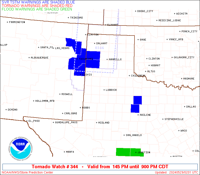
THE SEVERE WEATHER THREAT CONTINUES ACROSS THE ENTIRE WATCH AREA.
..MOORE..05/29/24
ATTN...WFO...LUB...
&&
STATUS REPORT FOR WT 344
SEVERE WEATHER THREAT CONTINUES FOR THE FOLLOWING AREAS
TXC017-045-069-075-079-101-107-125-153-169-189-191-219-263-269-
279-303-305-345-369-433-437-445-501-290240-
TX
. TEXAS COUNTIES INCLUDED ARE
BAILEY BRISCOE CASTRO
CHILDRESS COCHRAN COTTLE
CROSBY DICKENS FLOYD
GARZA HALE HALL
HOCKLEY KENT KING
LAMB LUBBOCK LYNN
MOTLEY PARMER STONEWALL
SWISHER TERRY YOAKUM
$$
THE WATCH STATUS MESSAGE IS FOR GUIDANCE PURPOSES ONLY. PLEASE
REFER TO WATCH COUNTY NOTIFICATION STATEMENTS FOR OFFICIAL
INFORMATION ON COUNTIES...INDEPENDENT CITIES AND MARINE ZONES
CLEARED FROM SEVERE THUNDERSTORM AND TORNADO WATCHES.
$$
STATUS REPORT #4 ON WW 344
VALID 290045Z - 290140Z
THE SEVERE WEATHER THREAT CONTINUES ACROSS THE ENTIRE WATCH AREA.
..BROYLES..05/29/24
ATTN...WFO...LUB...
&&
STATUS REPORT FOR WT 344
SEVERE WEATHER THREAT CONTINUES FOR THE FOLLOWING AREAS
TXC017-045-069-075-079-101-107-125-153-169-189-191-219-263-269-
279-303-305-345-369-433-437-445-501-290140-
TX
. TEXAS COUNTIES INCLUDED ARE
BAILEY BRISCOE CASTRO
CHILDRESS COCHRAN COTTLE
CROSBY DICKENS FLOYD
GARZA HALE HALL
HOCKLEY KENT KING
LAMB LUBBOCK LYNN
MOTLEY PARMER STONEWALL
SWISHER TERRY YOAKUM
$$
THE WATCH STATUS MESSAGE IS FOR GUIDANCE PURPOSES ONLY. PLEASE
REFER TO WATCH COUNTY NOTIFICATION STATEMENTS FOR OFFICIAL
INFORMATION ON COUNTIES...INDEPENDENT CITIES AND MARINE ZONES
CLEARED FROM SEVERE THUNDERSTORM AND TORNADO WATCHES.
$$
STATUS REPORT #3 ON WW 344
VALID 282345Z - 290040Z
THE SEVERE WEATHER THREAT CONTINUES ACROSS THE ENTIRE WATCH AREA.
..BROYLES..05/28/24
ATTN...WFO...LUB...
&&
STATUS REPORT FOR WT 344
SEVERE WEATHER THREAT CONTINUES FOR THE FOLLOWING AREAS
TXC017-045-069-075-079-101-107-125-153-169-189-191-219-263-269-
279-303-305-345-369-433-437-445-501-290040-
TX
. TEXAS COUNTIES INCLUDED ARE
BAILEY BRISCOE CASTRO
CHILDRESS COCHRAN COTTLE
CROSBY DICKENS FLOYD
GARZA HALE HALL
HOCKLEY KENT KING
LAMB LUBBOCK LYNN
MOTLEY PARMER STONEWALL
SWISHER TERRY YOAKUM
$$
THE WATCH STATUS MESSAGE IS FOR GUIDANCE PURPOSES ONLY. PLEASE
REFER TO WATCH COUNTY NOTIFICATION STATEMENTS FOR OFFICIAL
INFORMATION ON COUNTIES...INDEPENDENT CITIES AND MARINE ZONES
CLEARED FROM SEVERE THUNDERSTORM AND TORNADO WATCHES.
$$
STATUS REPORT #2 ON WW 344
VALID 282240Z - 282340Z
THE SEVERE WEATHER THREAT CONTINUES ACROSS THE ENTIRE WATCH AREA.
..BROYLES..05/28/24
ATTN...WFO...LUB...
&&
STATUS REPORT FOR WT 344
SEVERE WEATHER THREAT CONTINUES FOR THE FOLLOWING AREAS
TXC017-045-069-075-079-101-107-125-153-169-189-191-219-263-269-
279-303-305-345-369-433-437-445-501-282340-
TX
. TEXAS COUNTIES INCLUDED ARE
BAILEY BRISCOE CASTRO
CHILDRESS COCHRAN COTTLE
CROSBY DICKENS FLOYD
GARZA HALE HALL
HOCKLEY KENT KING
LAMB LUBBOCK LYNN
MOTLEY PARMER STONEWALL
SWISHER TERRY YOAKUM
$$
THE WATCH STATUS MESSAGE IS FOR GUIDANCE PURPOSES ONLY. PLEASE
REFER TO WATCH COUNTY NOTIFICATION STATEMENTS FOR OFFICIAL
INFORMATION ON COUNTIES...INDEPENDENT CITIES AND MARINE ZONES
CLEARED FROM SEVERE THUNDERSTORM AND TORNADO WATCHES.
$$
STATUS REPORT #1 ON WW 344
VALID 282135Z - 282240Z
THE SEVERE WEATHER THREAT CONTINUES ACROSS THE ENTIRE WATCH AREA.
..BROYLES..05/28/24
ATTN...WFO...LUB...
&&
STATUS REPORT FOR WT 344
SEVERE WEATHER THREAT CONTINUES FOR THE FOLLOWING AREAS
TXC017-045-069-075-079-101-107-125-153-169-189-191-219-263-269-
279-303-305-345-369-433-437-445-501-282240-
TX
. TEXAS COUNTIES INCLUDED ARE
BAILEY BRISCOE CASTRO
CHILDRESS COCHRAN COTTLE
CROSBY DICKENS FLOYD
GARZA HALE HALL
HOCKLEY KENT KING
LAMB LUBBOCK LYNN
MOTLEY PARMER STONEWALL
SWISHER TERRY YOAKUM
$$
THE WATCH STATUS MESSAGE IS FOR GUIDANCE PURPOSES ONLY. PLEASE
REFER TO WATCH COUNTY NOTIFICATION STATEMENTS FOR OFFICIAL
INFORMATION ON COUNTIES...INDEPENDENT CITIES AND MARINE ZONES
CLEARED FROM SEVERE THUNDERSTORM AND TORNADO WATCHES.
$$
Note:
Click for Complete Product Text.
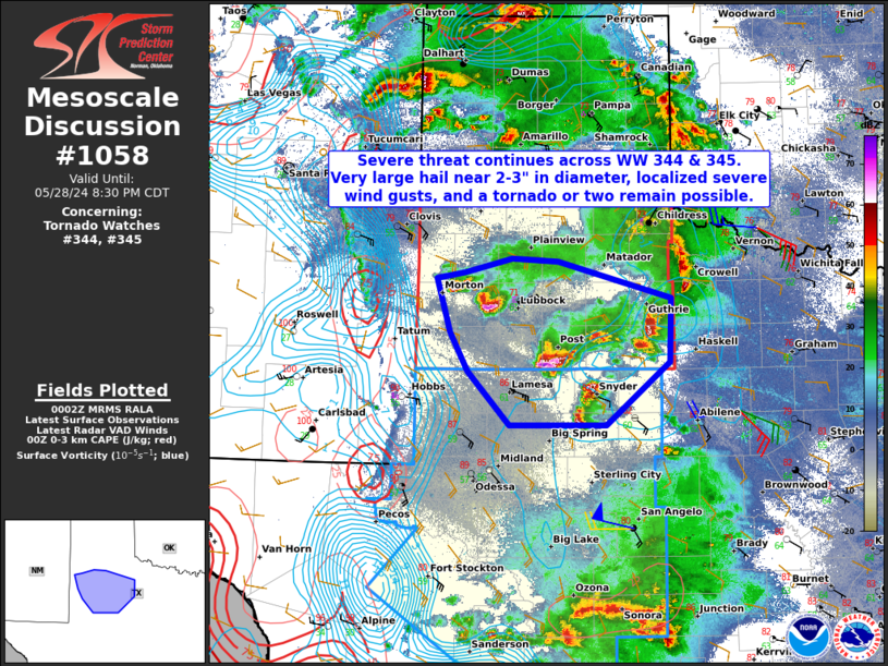
Tornadoes
Probability of 2 or more tornadoes
|
Mod (50%)
|
Probability of 1 or more strong (EF2-EF5) tornadoes
|
Low (20%)
|
Wind
Probability of 10 or more severe wind events
|
Mod (60%)
|
Probability of 1 or more wind events > 65 knots
|
Mod (60%)
|
Hail
Probability of 10 or more severe hail events
|
High (70%)
|
Probability of 1 or more hailstones > 2 inches
|
Mod (60%)
|
Combined Severe Hail/Wind
Probability of 6 or more combined severe hail/wind events
|
High (>95%)
|
For each watch, probabilities for particular events inside the watch
(listed above in each table) are determined by the issuing forecaster.
The "Low" category contains probability values ranging from less than 2%
to 20% (EF2-EF5 tornadoes), less than 5% to 20% (all other probabilities),
"Moderate" from 30% to 60%, and "High" from 70% to greater than 95%.
High values are bolded and lighter in color to provide awareness of
an increased threat for a particular event.


 @NWSSPC