 Note:
The expiration time in the watch graphic is amended if the watch is
replaced, cancelled or extended.
Note:
Note:
The expiration time in the watch graphic is amended if the watch is
replaced, cancelled or extended.
Note: Click for
Watch Status Reports.
SEL3
URGENT - IMMEDIATE BROADCAST REQUESTED
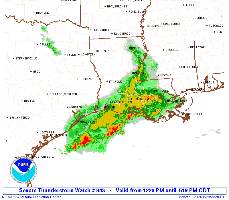
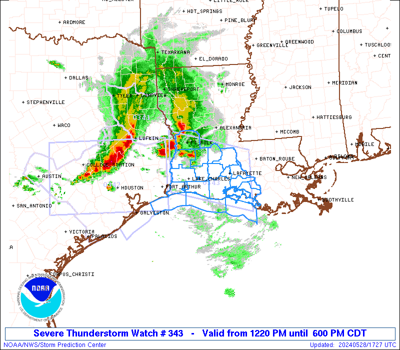
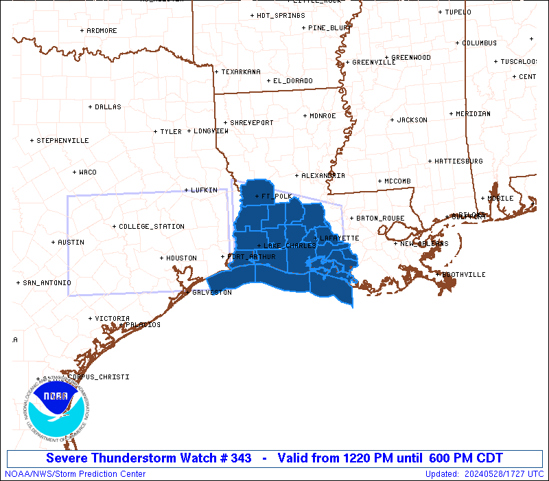
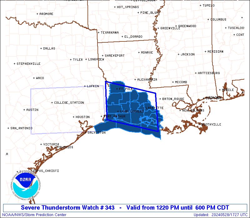
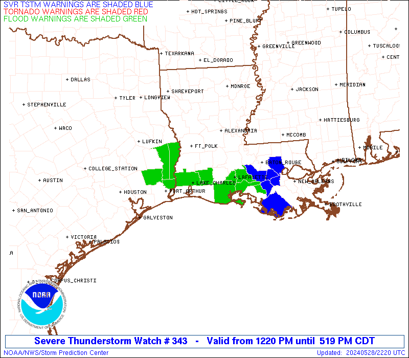
Severe Thunderstorm Watch Number 343
NWS Storm Prediction Center Norman OK
1220 PM CDT Tue May 28 2024
The NWS Storm Prediction Center has issued a
* Severe Thunderstorm Watch for portions of
Southwest Louisiana
Coastal Waters
* Effective this Tuesday afternoon and evening from 1220 PM until
600 PM CDT.
* Primary threats include...
Scattered damaging winds likely with isolated significant gusts
to 80 mph possible
Scattered large hail and isolated very large hail events to 2.5
inches in diameter possible
A tornado or two possible
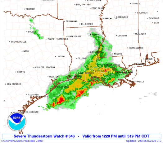
SUMMARY...A fast-moving line of thunderstorms over southeast Texas
will track across the watch area this afternoon, posing a risk of
significant damaging winds and hail.
The severe thunderstorm watch area is approximately along and 55
statute miles north and south of a line from 45 miles northwest of
Lake Charles LA to 40 miles east southeast of Lafayette LA. For a
complete depiction of the watch see the associated watch outline
update (WOUS64 KWNS WOU3).
PRECAUTIONARY/PREPAREDNESS ACTIONS...
REMEMBER...A Severe Thunderstorm Watch means conditions are
favorable for severe thunderstorms in and close to the watch area.
Persons in these areas should be on the lookout for threatening
weather conditions and listen for later statements and possible
warnings. Severe thunderstorms can and occasionally do produce
tornadoes.
&&
OTHER WATCH INFORMATION...CONTINUE...WW 342...
AVIATION...A few severe thunderstorms with hail surface and aloft to
2.5 inches. Extreme turbulence and surface wind gusts to 70 knots. A
few cumulonimbi with maximum tops to 500. Mean storm motion vector
29040.
...Hart

   SEL3

   URGENT - IMMEDIATE BROADCAST REQUESTED
   Severe Thunderstorm Watch Number 343
   NWS Storm Prediction Center Norman OK
   1220 PM CDT Tue May 28 2024

   The NWS Storm Prediction Center has issued a

   * Severe Thunderstorm Watch for portions of
     Southwest Louisiana
     Coastal Waters

   * Effective this Tuesday afternoon and evening from 1220 PM until
     600 PM CDT.

   * Primary threats include...
     Scattered damaging winds likely with isolated significant gusts
       to 80 mph possible
     Scattered large hail and isolated very large hail events to 2.5
       inches in diameter possible
     A tornado or two possible

   SUMMARY...A fast-moving line of thunderstorms over southeast Texas
   will track across the watch area this afternoon, posing a risk of
   significant damaging winds and hail.

   The severe thunderstorm watch area is approximately along and 55
   statute miles north and south of a line from 45 miles northwest of
   Lake Charles LA to 40 miles east southeast of Lafayette LA. For a
   complete depiction of the watch see the associated watch outline
   update (WOUS64 KWNS WOU3).

   PRECAUTIONARY/PREPAREDNESS ACTIONS...

   REMEMBER...A Severe Thunderstorm Watch means conditions are
   favorable for severe thunderstorms in and close to the watch area.
   Persons in these areas should be on the lookout for threatening
   weather conditions and listen for later statements and possible
   warnings. Severe thunderstorms can and occasionally do produce
   tornadoes.

   &&

   OTHER WATCH INFORMATION...CONTINUE...WW 342...

   AVIATION...A few severe thunderstorms with hail surface and aloft to
   2.5 inches. Extreme turbulence and surface wind gusts to 70 knots. A
   few cumulonimbi with maximum tops to 500. Mean storm motion vector
   29040.

   ...Hart
 Note:
The Aviation Watch (SAW) product is an approximation to the watch area.
The actual watch is depicted by the shaded areas.
Note:
The Aviation Watch (SAW) product is an approximation to the watch area.
The actual watch is depicted by the shaded areas.
   SAW3
   WW 343 SEVERE TSTM LA CW 281720Z - 282300Z
   AXIS..55 STATUTE MILES NORTH AND SOUTH OF LINE..
   45NW LCH/LAKE CHARLES LA/ - 40ESE LFT/LAFAYETTE LA/
   ..AVIATION COORDS.. 50NM N/S /43NW LCH - 30S BTR/
   HAIL SURFACE AND ALOFT..2.5 INCHES. WIND GUSTS..70 KNOTS.
   MAX TOPS TO 500. MEAN STORM MOTION VECTOR 29040.

   LAT...LON 31399375 30779136 29189136 29799375

   THIS IS AN APPROXIMATION TO THE WATCH AREA.  FOR A
   COMPLETE DEPICTION OF THE WATCH SEE WOUS64 KWNS
   FOR WOU3.
Watch 343 Status Report Messages:
STATUS REPORT #4 ON WW 343

VALID 282135Z - 282240Z

SEVERE WEATHER THREAT CONTINUES RIGHT OF A LINE FROM 40 SE BPT TO
30 E LCH TO 20 NW LFT TO 50 ENE LFT.

..BROYLES..05/28/24

ATTN...WFO...LCH...

&&

STATUS REPORT FOR WS 343

SEVERE WEATHER THREAT CONTINUES FOR THE FOLLOWING AREAS

LAC001-045-055-099-101-113-282240-

LA
.    LOUISIANA PARISHES INCLUDED ARE

ACADIA		     IBERIA		 LAFAYETTE
ST. MARTIN	     ST. MARY		 VERMILION
$$


GMZ435-436-452-455-282240-

CW

.    ADJACENT COASTAL WATERS INCLUDED ARE

VERMILION BAY


COASTAL WATERS FROM INTRACOASTAL CITY TO CAMERON LA OUT 20 NM

COASTAL WATERS FROM LOWER ATCHAFALAYA RIVER TO INTRACOASTAL CITY
LA OUT 20 NM

$$
THE WATCH STATUS MESSAGE IS FOR GUIDANCE PURPOSES ONLY.  PLEASE
REFER TO WATCH COUNTY NOTIFICATION STATEMENTS FOR OFFICIAL
INFORMATION ON COUNTIES...INDEPENDENT CITIES AND MARINE ZONES
CLEARED FROM SEVERE THUNDERSTORM AND TORNADO WATCHES.
$$

STATUS REPORT #3 ON WW 343

VALID 282030Z - 282140Z

SEVERE WEATHER THREAT CONTINUES RIGHT OF A LINE FROM 25 N BPT TO
40 NE LCH TO 45 NW HUM.

..LEITMAN..05/28/24

ATTN...WFO...LCH...

&&

STATUS REPORT FOR WS 343

SEVERE WEATHER THREAT CONTINUES FOR THE FOLLOWING AREAS

LAC001-019-023-045-053-055-099-101-113-282140-

LA
.    LOUISIANA PARISHES INCLUDED ARE

ACADIA		     CALCASIEU		 CAMERON
IBERIA		     JEFFERSON DAVIS	 LAFAYETTE
ST. MARTIN	     ST. MARY		 VERMILION
$$


GMZ432-435-436-450-452-455-282140-

CW

.    ADJACENT COASTAL WATERS INCLUDED ARE

CALCASIEU LAKE

VERMILION BAY


COASTAL WATERS FROM CAMERON LA TO HIGH ISLAND TX OUT 20 NM

COASTAL WATERS FROM INTRACOASTAL CITY TO CAMERON LA OUT 20 NM

COASTAL WATERS FROM LOWER ATCHAFALAYA RIVER TO INTRACOASTAL CITY
LA OUT 20 NM

$$
THE WATCH STATUS MESSAGE IS FOR GUIDANCE PURPOSES ONLY.  PLEASE
REFER TO WATCH COUNTY NOTIFICATION STATEMENTS FOR OFFICIAL
INFORMATION ON COUNTIES...INDEPENDENT CITIES AND MARINE ZONES
CLEARED FROM SEVERE THUNDERSTORM AND TORNADO WATCHES.
$$

STATUS REPORT #2 ON WW 343

VALID 281935Z - 282040Z

SEVERE WEATHER THREAT CONTINUES RIGHT OF A LINE FROM 45 NNE BPT
TO 20 S ESF.

..LEITMAN..05/28/24

ATTN...WFO...LCH...

&&

STATUS REPORT FOR WS 343

SEVERE WEATHER THREAT CONTINUES FOR THE FOLLOWING AREAS

LAC001-003-011-019-023-039-045-053-055-097-099-101-113-282040-

LA
.    LOUISIANA PARISHES INCLUDED ARE

ACADIA		     ALLEN		 BEAUREGARD
CALCASIEU	     CAMERON		 EVANGELINE
IBERIA		     JEFFERSON DAVIS	 LAFAYETTE
ST. LANDRY	     ST. MARTIN 	 ST. MARY
VERMILION
$$


GMZ432-435-436-450-452-455-282040-

CW

.    ADJACENT COASTAL WATERS INCLUDED ARE

CALCASIEU LAKE

VERMILION BAY


COASTAL WATERS FROM CAMERON LA TO HIGH ISLAND TX OUT 20 NM

COASTAL WATERS FROM INTRACOASTAL CITY TO CAMERON LA OUT 20 NM

COASTAL WATERS FROM LOWER ATCHAFALAYA RIVER TO INTRACOASTAL CITY
LA OUT 20 NM

$$
THE WATCH STATUS MESSAGE IS FOR GUIDANCE PURPOSES ONLY.  PLEASE
REFER TO WATCH COUNTY NOTIFICATION STATEMENTS FOR OFFICIAL
INFORMATION ON COUNTIES...INDEPENDENT CITIES AND MARINE ZONES
CLEARED FROM SEVERE THUNDERSTORM AND TORNADO WATCHES.
$$

STATUS REPORT #1 ON WW 343

VALID 281815Z - 281940Z

THE SEVERE WEATHER THREAT CONTINUES ACROSS THE ENTIRE WATCH AREA.

..LEITMAN..05/28/24

ATTN...WFO...LCH...

&&

STATUS REPORT FOR WS 343

SEVERE WEATHER THREAT CONTINUES FOR THE FOLLOWING AREAS

LAC001-003-011-019-023-039-045-053-055-097-099-101-113-115-
281940-

LA
.    LOUISIANA PARISHES INCLUDED ARE

ACADIA		     ALLEN		 BEAUREGARD
CALCASIEU	     CAMERON		 EVANGELINE
IBERIA		     JEFFERSON DAVIS	 LAFAYETTE
ST. LANDRY	     ST. MARTIN 	 ST. MARY
VERMILION	     VERNON
$$


GMZ432-435-436-450-452-455-281940-

CW

.    ADJACENT COASTAL WATERS INCLUDED ARE

CALCASIEU LAKE

VERMILION BAY


COASTAL WATERS FROM CAMERON LA TO HIGH ISLAND TX OUT 20 NM

COASTAL WATERS FROM INTRACOASTAL CITY TO CAMERON LA OUT 20 NM

COASTAL WATERS FROM LOWER ATCHAFALAYA RIVER TO INTRACOASTAL CITY
LA OUT 20 NM

$$
THE WATCH STATUS MESSAGE IS FOR GUIDANCE PURPOSES ONLY.  PLEASE
REFER TO WATCH COUNTY NOTIFICATION STATEMENTS FOR OFFICIAL
INFORMATION ON COUNTIES...INDEPENDENT CITIES AND MARINE ZONES
CLEARED FROM SEVERE THUNDERSTORM AND TORNADO WATCHES.
$$
Note:
Click for Complete Product Text.
Tornadoes
Probability of 2 or more tornadoes
|
Low (20%)
|
Probability of 1 or more strong (EF2-EF5) tornadoes
|
Low (<2%)
|
Wind
Probability of 10 or more severe wind events
|
High (70%)
|
Probability of 1 or more wind events > 65 knots
|
Mod (30%)
|
Hail
Probability of 10 or more severe hail events
|
Mod (40%)
|
Probability of 1 or more hailstones > 2 inches
|
Mod (30%)
|
Combined Severe Hail/Wind
Probability of 6 or more combined severe hail/wind events
|
High (90%)
|
For each watch, probabilities for particular events inside the watch
(listed above in each table) are determined by the issuing forecaster.
The "Low" category contains probability values ranging from less than 2%
to 20% (EF2-EF5 tornadoes), less than 5% to 20% (all other probabilities),
"Moderate" from 30% to 60%, and "High" from 70% to greater than 95%.
High values are bolded and lighter in color to provide awareness of
an increased threat for a particular event.


 @NWSSPC