 Note:
The expiration time in the watch graphic is amended if the watch is
replaced, cancelled or extended.
Note:
Note:
The expiration time in the watch graphic is amended if the watch is
replaced, cancelled or extended.
Note: Click for
Watch Status Reports.
SEL4
URGENT - IMMEDIATE BROADCAST REQUESTED
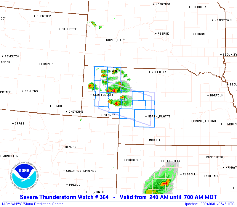
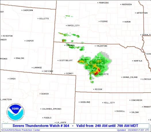
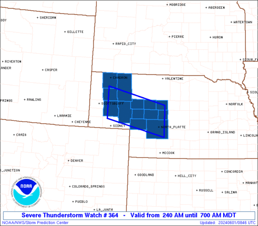
Severe Thunderstorm Watch Number 364
NWS Storm Prediction Center Norman OK
240 AM MDT Sat Jun 1 2024
The NWS Storm Prediction Center has issued a
* Severe Thunderstorm Watch for portions of
Western Nebraska
* Effective this Saturday morning from 240 AM until 700 AM MDT.
* Primary threats include...
Isolated large hail events to 1.5 inches in diameter possible
SUMMARY...A few elevated supercells may persist through about
sunrise with the potential to produce occasional large hail of 1-1.5
inches in diameter.
The severe thunderstorm watch area is approximately along and 40
statute miles north and south of a line from 20 miles west southwest
of Alliance NE to 20 miles northeast of North Platte NE. For a
complete depiction of the watch see the associated watch outline
update (WOUS64 KWNS WOU4).
PRECAUTIONARY/PREPAREDNESS ACTIONS...
REMEMBER...A Severe Thunderstorm Watch means conditions are
favorable for severe thunderstorms in and close to the watch area.
Persons in these areas should be on the lookout for threatening
weather conditions and listen for later statements and possible
warnings. Severe thunderstorms can and occasionally do produce
tornadoes.
&&
AVIATION...A few severe thunderstorms with hail surface and aloft to
1.5 inches. Extreme turbulence and surface wind gusts to 50 knots. A
few cumulonimbi with maximum tops to 450. Mean storm motion vector
31020.
...Thompson
 Note:
The Aviation Watch (SAW) product is an approximation to the watch area.
The actual watch is depicted by the shaded areas.
Note:
The Aviation Watch (SAW) product is an approximation to the watch area.
The actual watch is depicted by the shaded areas.
   SAW4
   WW 364 SEVERE TSTM NE 010840Z - 011300Z
   AXIS..40 STATUTE MILES NORTH AND SOUTH OF LINE..
   20WSW AIA/ALLIANCE NE/ - 20NE LBF/NORTH PLATTE NE/
   ..AVIATION COORDS.. 35NM N/S /15ENE BFF - 19NE LBF/
   HAIL SURFACE AND ALOFT..1.5 INCHES. WIND GUSTS..50 KNOTS.
   MAX TOPS TO 450. MEAN STORM MOTION VECTOR 31020.

   LAT...LON 42520316 41910041 40750041 41360316

   THIS IS AN APPROXIMATION TO THE WATCH AREA.  FOR A
   COMPLETE DEPICTION OF THE WATCH SEE WOUS64 KWNS
   FOR WOU4.
Watch 364 Status Report Messages:
STATUS REPORT #4 ON WW 364
VALID 011240Z - 011300Z
SEVERE WEATHER THREAT CONTINUES RIGHT OF A LINE FROM 25 SW LBF TO
50 ESE AIA TO 45 WNW MHN.
WW 364 WILL BE ALLOWED TO EXPIRE AT 011300Z.
..GRAMS..06/01/24
ATTN...WFO...LBF...CYS...
&&
STATUS REPORT FOR WS 364
SEVERE WEATHER THREAT CONTINUES FOR THE FOLLOWING AREAS
NEC005-075-091-111-113-117-171-011300-
NE
. NEBRASKA COUNTIES INCLUDED ARE
ARTHUR GRANT HOOKER
LINCOLN LOGAN MCPHERSON
THOMAS
$$
THE WATCH STATUS MESSAGE IS FOR GUIDANCE PURPOSES ONLY. PLEASE
REFER TO WATCH COUNTY NOTIFICATION STATEMENTS FOR OFFICIAL
INFORMATION ON COUNTIES...INDEPENDENT CITIES AND MARINE ZONES
CLEARED FROM SEVERE THUNDERSTORM AND TORNADO WATCHES.
$$
STATUS REPORT #3 ON WW 364
VALID 011140Z - 011240Z
SEVERE WEATHER THREAT CONTINUES RIGHT OF A LINE FROM 50 E SNY TO
30 NE AIA.
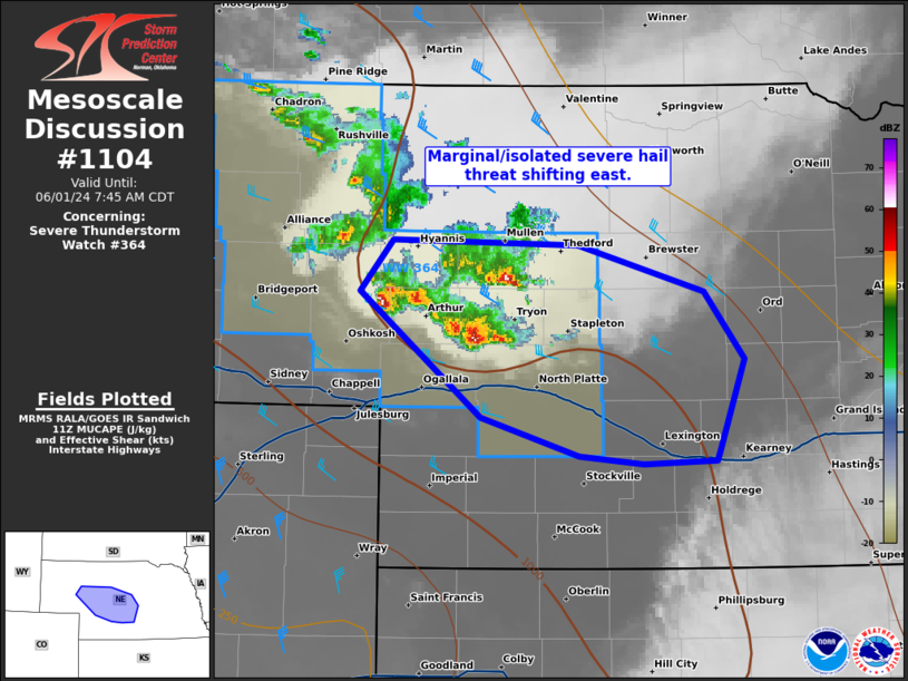
FOR ADDITIONAL INFORMATION SEE MESOSCALE DISCUSSION 1104.
..GRAMS..06/01/24
ATTN...WFO...LBF...CYS...
&&
STATUS REPORT FOR WS 364
SEVERE WEATHER THREAT CONTINUES FOR THE FOLLOWING AREAS
NEC005-075-091-101-111-113-117-171-011240-
NE
. NEBRASKA COUNTIES INCLUDED ARE
ARTHUR GRANT HOOKER
KEITH LINCOLN LOGAN
MCPHERSON THOMAS
$$
THE WATCH STATUS MESSAGE IS FOR GUIDANCE PURPOSES ONLY. PLEASE
REFER TO WATCH COUNTY NOTIFICATION STATEMENTS FOR OFFICIAL
INFORMATION ON COUNTIES...INDEPENDENT CITIES AND MARINE ZONES
CLEARED FROM SEVERE THUNDERSTORM AND TORNADO WATCHES.
$$
STATUS REPORT #2 ON WW 364
VALID 011040Z - 011140Z
SEVERE WEATHER THREAT CONTINUES RIGHT OF A LINE FROM 35 E SNY TO
20 S CDR.
..GRAMS..06/01/24
ATTN...WFO...LBF...CYS...
&&
STATUS REPORT FOR WS 364
SEVERE WEATHER THREAT CONTINUES FOR THE FOLLOWING AREAS
NEC005-045-069-075-091-101-111-113-117-161-171-011140-
NE
. NEBRASKA COUNTIES INCLUDED ARE
ARTHUR DAWES GARDEN
GRANT HOOKER KEITH
LINCOLN LOGAN MCPHERSON
SHERIDAN THOMAS
$$
THE WATCH STATUS MESSAGE IS FOR GUIDANCE PURPOSES ONLY. PLEASE
REFER TO WATCH COUNTY NOTIFICATION STATEMENTS FOR OFFICIAL
INFORMATION ON COUNTIES...INDEPENDENT CITIES AND MARINE ZONES
CLEARED FROM SEVERE THUNDERSTORM AND TORNADO WATCHES.
$$
STATUS REPORT #1 ON WW 364
VALID 010930Z - 011040Z
THE SEVERE WEATHER THREAT CONTINUES ACROSS THE ENTIRE WATCH AREA.
..GRAMS..06/01/24
ATTN...WFO...LBF...CYS...
&&
STATUS REPORT FOR WS 364
SEVERE WEATHER THREAT CONTINUES FOR THE FOLLOWING AREAS
NEC005-013-045-069-075-091-101-111-113-117-123-161-171-011040-
NE
. NEBRASKA COUNTIES INCLUDED ARE
ARTHUR BOX BUTTE DAWES
GARDEN GRANT HOOKER
KEITH LINCOLN LOGAN
MCPHERSON MORRILL SHERIDAN
THOMAS
$$
THE WATCH STATUS MESSAGE IS FOR GUIDANCE PURPOSES ONLY. PLEASE
REFER TO WATCH COUNTY NOTIFICATION STATEMENTS FOR OFFICIAL
INFORMATION ON COUNTIES...INDEPENDENT CITIES AND MARINE ZONES
CLEARED FROM SEVERE THUNDERSTORM AND TORNADO WATCHES.
$$
Note:
Click for Complete Product Text.
Tornadoes
Probability of 2 or more tornadoes
|
Low (<5%)
|
Probability of 1 or more strong (EF2-EF5) tornadoes
|
Low (<2%)
|
Wind
Probability of 10 or more severe wind events
|
Low (10%)
|
Probability of 1 or more wind events > 65 knots
|
Low (<5%)
|
Hail
Probability of 10 or more severe hail events
|
Mod (30%)
|
Probability of 1 or more hailstones > 2 inches
|
Low (10%)
|
Combined Severe Hail/Wind
Probability of 6 or more combined severe hail/wind events
|
Mod (50%)
|
For each watch, probabilities for particular events inside the watch
(listed above in each table) are determined by the issuing forecaster.
The "Low" category contains probability values ranging from less than 2%
to 20% (EF2-EF5 tornadoes), less than 5% to 20% (all other probabilities),
"Moderate" from 30% to 60%, and "High" from 70% to greater than 95%.
High values are bolded and lighter in color to provide awareness of
an increased threat for a particular event.


 @NWSSPC