Note:
The expiration time in the watch graphic is amended if the watch is
replaced, cancelled or extended.
Note:
Note:
The expiration time in the watch graphic is amended if the watch is
replaced, cancelled or extended.
Note: Click for
Watch Status Reports.
SEL8
URGENT - IMMEDIATE BROADCAST REQUESTED
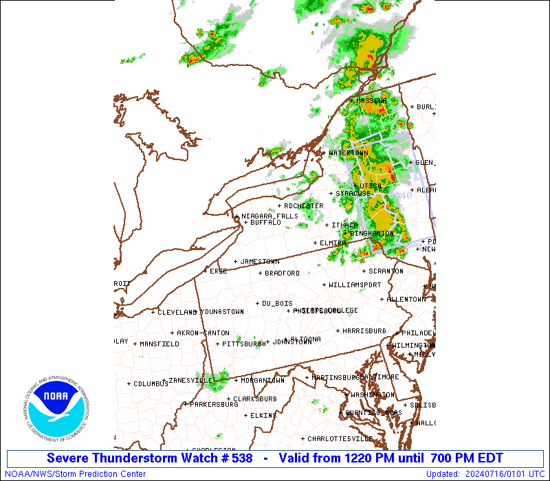
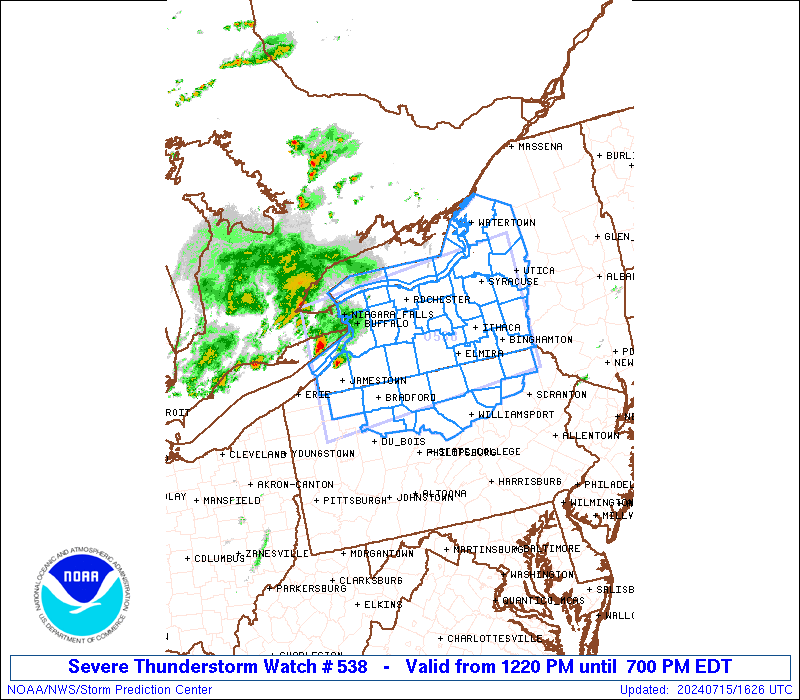
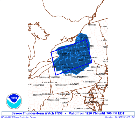
Severe Thunderstorm Watch Number 538
NWS Storm Prediction Center Norman OK
1220 PM EDT Mon Jul 15 2024
The NWS Storm Prediction Center has issued a
* Severe Thunderstorm Watch for portions of
Western and Central New York
Northern Pennsylvania
Lake Erie
Lake Ontario
* Effective this Monday afternoon and evening from 1220 PM until
700 PM EDT.
* Primary threats include...
Scattered damaging wind gusts to 70 mph likely
Isolated large hail events to 1.5 inches in diameter possible
SUMMARY...Scattered thunderstorms are expected to intensify through
the afternoon and spread eastward across the watch area. The
strongest cells will pose a risk of damaging wind gusts and some
hail.
The severe thunderstorm watch area is approximately along and 70
statute miles north and south of a line from 30 miles west northwest
of Jamestown NY to 30 miles south of Utica NY. For a complete
depiction of the watch see the associated watch outline update
(WOUS64 KWNS WOU8).
PRECAUTIONARY/PREPAREDNESS ACTIONS...
REMEMBER...A Severe Thunderstorm Watch means conditions are
favorable for severe thunderstorms in and close to the watch area.
Persons in these areas should be on the lookout for threatening
weather conditions and listen for later statements and possible
warnings. Severe thunderstorms can and occasionally do produce
tornadoes.
&&
AVIATION...A few severe thunderstorms with hail surface and aloft to
1.5 inches. Extreme turbulence and surface wind gusts to 60 knots. A
few cumulonimbi with maximum tops to 500. Mean storm motion vector
27030.
...Hart
 Note:
The Aviation Watch (SAW) product is an approximation to the watch area.
The actual watch is depicted by the shaded areas.
Note:
The Aviation Watch (SAW) product is an approximation to the watch area.
The actual watch is depicted by the shaded areas.
   SAW8
   WW 538 SEVERE TSTM NY PA LE LO 151620Z - 152300Z
   AXIS..70 STATUTE MILES NORTH AND SOUTH OF LINE..
   30WNW JHW/JAMESTOWN NY/ - 30S UCA/UTICA NY/
   ..AVIATION COORDS.. 60NM N/S /29NE ERI - 39N HNK/
   HAIL SURFACE AND ALOFT..1.5 INCHES. WIND GUSTS..60 KNOTS.
   MAX TOPS TO 500. MEAN STORM MOTION VECTOR 27030.

   LAT...LON 43337979 43737537 41707537 41307979

   THIS IS AN APPROXIMATION TO THE WATCH AREA.  FOR A
   COMPLETE DEPICTION OF THE WATCH SEE WOUS64 KWNS
   FOR WOU8.
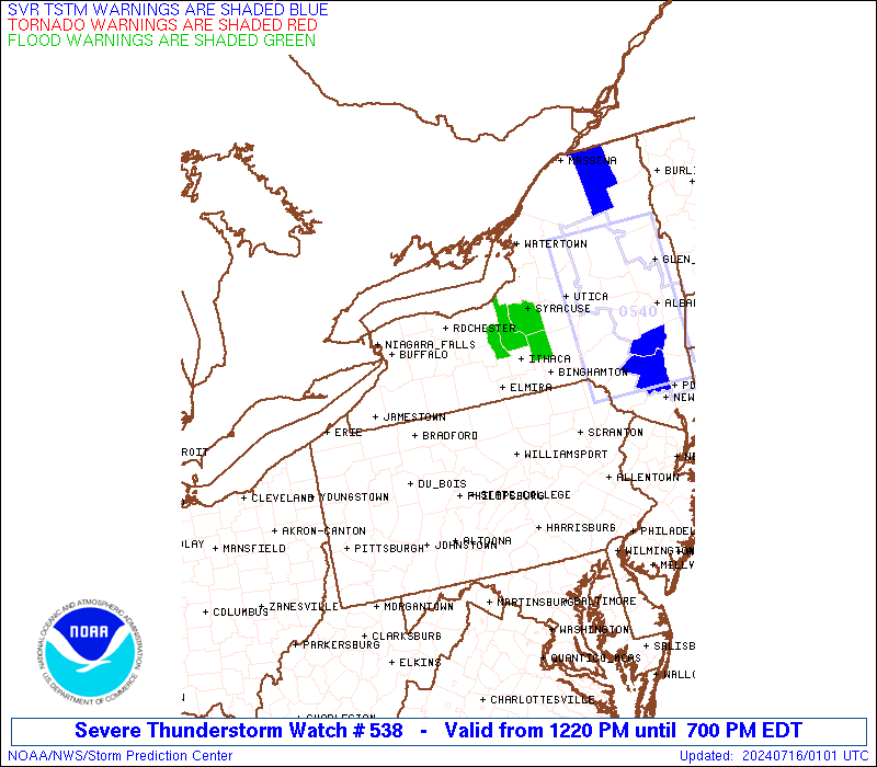
Watch 538 Status Report Messages:
STATUS REPORT #3 ON WW 538
VALID 152245Z - 152340Z
SEVERE WEATHER THREAT CONTINUES RIGHT OF A LINE FROM 30 SSW IPT
TO 20 SSE ELM TO 20 W SYR TO 35 NW ART.
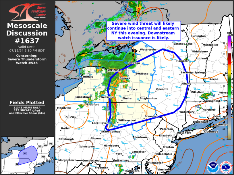
FOR ADDITIONAL INFORMATION SEE MESOSCALE DISCUSSION 1637
..MOORE..07/15/24
ATTN...WFO...BUF...BGM...CTP...
&&
STATUS REPORT FOR WS 538
SEVERE WEATHER THREAT CONTINUES FOR THE FOLLOWING AREAS
NYC007-017-023-045-049-053-065-067-107-109-152340-
NY
. NEW YORK COUNTIES INCLUDED ARE
BROOME CHENANGO CORTLAND
JEFFERSON LEWIS MADISON
ONEIDA ONONDAGA TIOGA
TOMPKINS
$$
PAC015-069-079-113-115-127-131-152340-
PA
. PENNSYLVANIA COUNTIES INCLUDED ARE
BRADFORD LACKAWANNA LUZERNE
SULLIVAN SUSQUEHANNA WAYNE
WYOMING
$$
LOZ030-044-045-065-152340-
CW
. ADJACENT COASTAL WATERS INCLUDED ARE
LOWER NIAGARA RIVER
SODUS BAY TO MEXICO BAY NY
MEXICO BAY NY TO THE ST. LAWRENCE RIVER
MEXICO BAY NY TO THE ST. LAWRENCE RIVER BEYOND 5NM OFF SHORELINE
TO US-CANADIAN BORDER
$$
THE WATCH STATUS MESSAGE IS FOR GUIDANCE PURPOSES ONLY. PLEASE
REFER TO WATCH COUNTY NOTIFICATION STATEMENTS FOR OFFICIAL
INFORMATION ON COUNTIES...INDEPENDENT CITIES AND MARINE ZONES
CLEARED FROM SEVERE THUNDERSTORM AND TORNADO WATCHES.
$$
STATUS REPORT #2 ON WW 538
VALID 151945Z - 152040Z
THE SEVERE WEATHER THREAT CONTINUES ACROSS THE ENTIRE WATCH AREA.
..DEAN..07/15/24
ATTN...WFO...BUF...BGM...CTP...
&&
STATUS REPORT FOR WS 538
SEVERE WEATHER THREAT CONTINUES FOR THE FOLLOWING AREAS
NYC003-007-009-011-013-015-017-023-029-037-045-049-051-053-055-
063-065-067-069-073-075-097-099-101-107-109-117-121-123-
152040-
NY
. NEW YORK COUNTIES INCLUDED ARE
ALLEGANY BROOME CATTARAUGUS
CAYUGA CHAUTAUQUA CHEMUNG
CHENANGO CORTLAND ERIE
GENESEE JEFFERSON LEWIS
LIVINGSTON MADISON MONROE
NIAGARA ONEIDA ONONDAGA
ONTARIO ORLEANS OSWEGO
SCHUYLER SENECA STEUBEN
TIOGA TOMPKINS WAYNE
WYOMING YATES
$$
PAC015-023-035-047-081-083-105-113-115-117-123-131-152040-
PA
. PENNSYLVANIA COUNTIES INCLUDED ARE
BRADFORD CAMERON CLINTON
ELK LYCOMING MCKEAN
POTTER SULLIVAN SUSQUEHANNA
TIOGA WARREN WYOMING
$$
LEZ020-040-041-061-LOZ030-042-043-044-045-062-063-064-065-
152040-
CW
. ADJACENT COASTAL WATERS INCLUDED ARE
LOWER NIAGARA RIVER
NIAGARA RIVER TO HAMLIN BEACH NY
HAMLIN BEACH TO SODUS BAY NY
SODUS BAY TO MEXICO BAY NY
MEXICO BAY NY TO THE ST. LAWRENCE RIVER
NIAGARA RIVER TO HAMLIN BEACH NY BEYOND 5NM OFF SHORELINE TO
US-CANADIAN BORDER
HAMLIN BEACH TO SODUS BAY NY BEYOND 5NM OFF SHORELINE TO
US-CANADIAN BORDER
SODUS BAY TO MEXICO BAY NY BEYOND 5NM OFF SHORELINE TO
US-CANADIAN BORDER
MEXICO BAY NY TO THE ST. LAWRENCE RIVER BEYOND 5NM OFF SHORELINE
TO US-CANADIAN BORDER
UPPER NIAGARA RIVER AND BUFFALO HARBOR
RIPLEY TO DUNKIRK NY
DUNKIRK TO BUFFALO NY
RIPLEY TO BUFFALO NY EXTENDING FROM 5NM OFF SHORELINE TO
US-CANADIAN BORDER
$$
THE WATCH STATUS MESSAGE IS FOR GUIDANCE PURPOSES ONLY. PLEASE
REFER TO WATCH COUNTY NOTIFICATION STATEMENTS FOR OFFICIAL
INFORMATION ON COUNTIES...INDEPENDENT CITIES AND MARINE ZONES
CLEARED FROM SEVERE THUNDERSTORM AND TORNADO WATCHES.
$$
STATUS REPORT #1 ON WW 538
VALID 151645Z - 151740Z
THE SEVERE WEATHER THREAT CONTINUES ACROSS THE ENTIRE WATCH AREA.
..DEAN..07/15/24
ATTN...WFO...BUF...BGM...CTP...
&&
STATUS REPORT FOR WS 538
SEVERE WEATHER THREAT CONTINUES FOR THE FOLLOWING AREAS
NYC003-007-009-011-013-015-017-023-029-037-045-049-051-053-055-
063-065-067-069-073-075-097-099-101-107-109-117-121-123-
151740-
NY
. NEW YORK COUNTIES INCLUDED ARE
ALLEGANY BROOME CATTARAUGUS
CAYUGA CHAUTAUQUA CHEMUNG
CHENANGO CORTLAND ERIE
GENESEE JEFFERSON LEWIS
LIVINGSTON MADISON MONROE
NIAGARA ONEIDA ONONDAGA
ONTARIO ORLEANS OSWEGO
SCHUYLER SENECA STEUBEN
TIOGA TOMPKINS WAYNE
WYOMING YATES
$$
PAC015-023-035-047-081-083-105-113-115-117-123-131-151740-
PA
. PENNSYLVANIA COUNTIES INCLUDED ARE
BRADFORD CAMERON CLINTON
ELK LYCOMING MCKEAN
POTTER SULLIVAN SUSQUEHANNA
TIOGA WARREN WYOMING
$$
LEZ020-040-041-061-LOZ030-042-043-044-045-062-063-064-065-
151740-
CW
. ADJACENT COASTAL WATERS INCLUDED ARE
LOWER NIAGARA RIVER
NIAGARA RIVER TO HAMLIN BEACH NY
HAMLIN BEACH TO SODUS BAY NY
SODUS BAY TO MEXICO BAY NY
MEXICO BAY NY TO THE ST. LAWRENCE RIVER
NIAGARA RIVER TO HAMLIN BEACH NY BEYOND 5NM OFF SHORELINE TO
US-CANADIAN BORDER
HAMLIN BEACH TO SODUS BAY NY BEYOND 5NM OFF SHORELINE TO
US-CANADIAN BORDER
SODUS BAY TO MEXICO BAY NY BEYOND 5NM OFF SHORELINE TO
US-CANADIAN BORDER
MEXICO BAY NY TO THE ST. LAWRENCE RIVER BEYOND 5NM OFF SHORELINE
TO US-CANADIAN BORDER
UPPER NIAGARA RIVER AND BUFFALO HARBOR
RIPLEY TO DUNKIRK NY
DUNKIRK TO BUFFALO NY
RIPLEY TO BUFFALO NY EXTENDING FROM 5NM OFF SHORELINE TO
US-CANADIAN BORDER
$$
THE WATCH STATUS MESSAGE IS FOR GUIDANCE PURPOSES ONLY. PLEASE
REFER TO WATCH COUNTY NOTIFICATION STATEMENTS FOR OFFICIAL
INFORMATION ON COUNTIES...INDEPENDENT CITIES AND MARINE ZONES
CLEARED FROM SEVERE THUNDERSTORM AND TORNADO WATCHES.
$$
Note:
Click for Complete Product Text.
Tornadoes
Probability of 2 or more tornadoes
|
Low (10%)
|
Probability of 1 or more strong (EF2-EF5) tornadoes
|
Low (<2%)
|
Wind
Probability of 10 or more severe wind events
|
Mod (60%)
|
Probability of 1 or more wind events > 65 knots
|
Low (20%)
|
Hail
Probability of 10 or more severe hail events
|
Low (20%)
|
Probability of 1 or more hailstones > 2 inches
|
Low (10%)
|
Combined Severe Hail/Wind
Probability of 6 or more combined severe hail/wind events
|
High (80%)
|
For each watch, probabilities for particular events inside the watch
(listed above in each table) are determined by the issuing forecaster.
The "Low" category contains probability values ranging from less than 2%
to 20% (EF2-EF5 tornadoes), less than 5% to 20% (all other probabilities),
"Moderate" from 30% to 60%, and "High" from 70% to greater than 95%.
High values are bolded and lighter in color to provide awareness of
an increased threat for a particular event.


 @NWSSPC