Note:
The expiration time in the watch graphic is amended if the watch is
replaced, cancelled or extended.
Note:
Note:
The expiration time in the watch graphic is amended if the watch is
replaced, cancelled or extended.
Note: Click for
Watch Status Reports.
SEL9
URGENT - IMMEDIATE BROADCAST REQUESTED
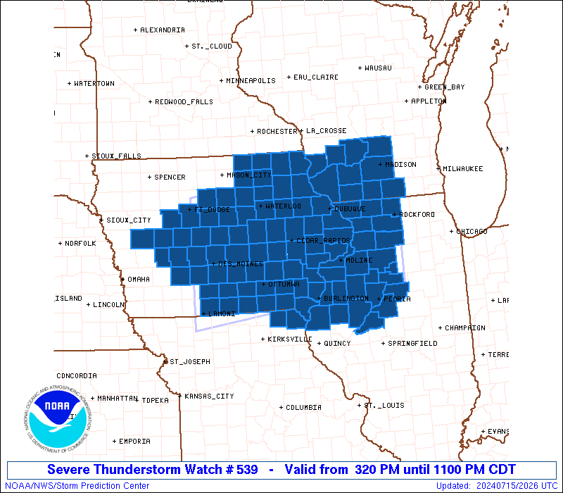
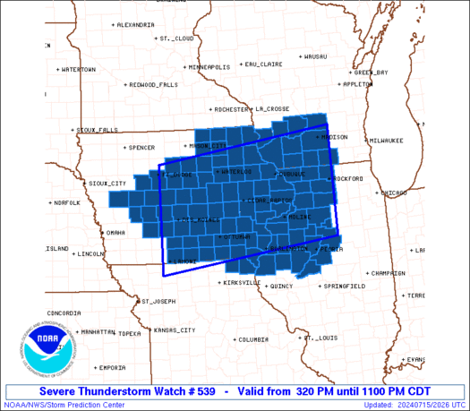
Severe Thunderstorm Watch Number 539
NWS Storm Prediction Center Norman OK
320 PM CDT Mon Jul 15 2024
The NWS Storm Prediction Center has issued a
* Severe Thunderstorm Watch for portions of
Central and Eastern Iowa
Northwest Illinois
Northeast Missouri
Southwest Wisconsin
* Effective this Monday afternoon and evening from 320 PM until
1100 PM CDT.
* Primary threats include...
Widespread damaging winds and isolated significant gusts to 85
mph likely
Scattered large hail likely with isolated very large hail events
to 2.5 inches in diameter possible
A tornado or two possible
SUMMARY...Intense thunderstorms will soon develop across Iowa in a
very moist and unstable air mass. Activity will track eastward and
organize into a fast-moving bowing cluster, capable of very damaging
wind gusts and large hail. A tornado or two is also possible across
this region.
The severe thunderstorm watch area is approximately along and 85
statute miles north and south of a line from 25 miles west of Des
Moines IA to 5 miles east southeast of Rockford IL. For a complete
depiction of the watch see the associated watch outline update
(WOUS64 KWNS WOU9).
PRECAUTIONARY/PREPAREDNESS ACTIONS...
REMEMBER...A Severe Thunderstorm Watch means conditions are
favorable for severe thunderstorms in and close to the watch area.
Persons in these areas should be on the lookout for threatening
weather conditions and listen for later statements and possible
warnings. Severe thunderstorms can and occasionally do produce
tornadoes.
&&
OTHER WATCH INFORMATION...CONTINUE...WW 538...
AVIATION...A few severe thunderstorms with hail surface and aloft to
2.5 inches. Extreme turbulence and surface wind gusts to 75 knots. A
few cumulonimbi with maximum tops to 600. Mean storm motion vector
27035.
...Hart
   SEL9

   URGENT - IMMEDIATE BROADCAST REQUESTED
   Severe Thunderstorm Watch Number 539
   NWS Storm Prediction Center Norman OK
   320 PM CDT Mon Jul 15 2024

   The NWS Storm Prediction Center has issued a

   * Severe Thunderstorm Watch for portions of
     Central and Eastern Iowa
     Northwest Illinois
     Northeast Missouri
     Southwest Wisconsin

   * Effective this Monday afternoon and evening from 320 PM until
     1100 PM CDT.

   * Primary threats include...
     Widespread damaging winds and isolated significant gusts to 85
       mph likely
     Scattered large hail likely with isolated very large hail events
       to 2.5 inches in diameter possible
     A tornado or two possible

   SUMMARY...Intense thunderstorms will soon develop across Iowa in a
   very moist and unstable air mass.  Activity will track eastward and
   organize into a fast-moving bowing cluster, capable of very damaging
   wind gusts and large hail.  A tornado or two is also possible across
   this region.

   The severe thunderstorm watch area is approximately along and 85
   statute miles north and south of a line from 25 miles west of Des
   Moines IA to 5 miles east southeast of Rockford IL. For a complete
   depiction of the watch see the associated watch outline update
   (WOUS64 KWNS WOU9).

   PRECAUTIONARY/PREPAREDNESS ACTIONS...

   REMEMBER...A Severe Thunderstorm Watch means conditions are
   favorable for severe thunderstorms in and close to the watch area.
   Persons in these areas should be on the lookout for threatening
   weather conditions and listen for later statements and possible
   warnings. Severe thunderstorms can and occasionally do produce
   tornadoes.

   &&

   OTHER WATCH INFORMATION...CONTINUE...WW 538...

   AVIATION...A few severe thunderstorms with hail surface and aloft to
   2.5 inches. Extreme turbulence and surface wind gusts to 75 knots. A
   few cumulonimbi with maximum tops to 600. Mean storm motion vector
   27035.

   ...Hart
 Note:
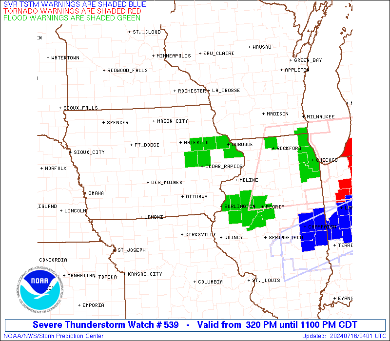
The Aviation Watch (SAW) product is an approximation to the watch area.
The actual watch is depicted by the shaded areas.
Note:
The Aviation Watch (SAW) product is an approximation to the watch area.
The actual watch is depicted by the shaded areas.
   SAW9
   WW 539 SEVERE TSTM IA IL MO WI 152020Z - 160400Z
   AXIS..85 STATUTE MILES NORTH AND SOUTH OF LINE..
   25W DSM/DES MOINES IA/ - 5ESE RFD/ROCKFORD IL/
   ..AVIATION COORDS.. 75NM N/S /23WNW DSM - 48NW JOT/
   HAIL SURFACE AND ALOFT..2.5 INCHES. WIND GUSTS..75 KNOTS.
   MAX TOPS TO 600. MEAN STORM MOTION VECTOR 27035.

   LAT...LON 42769415 43408901 40938901 40309415

   THIS IS AN APPROXIMATION TO THE WATCH AREA.  FOR A
   COMPLETE DEPICTION OF THE WATCH SEE WOUS64 KWNS
   FOR WOU9.
Watch 539 Status Report Messages:
STATUS REPORT #4 ON WW 539
VALID 160135Z - 160240Z
SEVERE WEATHER THREAT CONTINUES RIGHT OF A LINE FROM 15 N IRK TO
30 ESE OTM TO 25 SSW MLI TO 35 SSW OSH.
..MOORE..07/16/24
ATTN...WFO...DMX...ARX...DVN...ILX...LOT...MKX...
&&
STATUS REPORT FOR WS 539
SEVERE WEATHER THREAT CONTINUES FOR THE FOLLOWING AREAS
ILC067-071-109-187-160240-
IL
. ILLINOIS COUNTIES INCLUDED ARE
HANCOCK HENDERSON MCDONOUGH
WARREN
$$
IAC057-087-111-177-160240-
IA
. IOWA COUNTIES INCLUDED ARE
DES MOINES HENRY LEE
VAN BUREN
$$
MOC045-199-160240-
MO
. MISSOURI COUNTIES INCLUDED ARE
CLARK SCOTLAND
$$
WIC055-079-133-160240-
WI
. WISCONSIN COUNTIES INCLUDED ARE
JEFFERSON MILWAUKEE WAUKESHA
$$
LMZ645-160240-
CW
. ADJACENT COASTAL WATERS INCLUDED ARE
LMZ645
$$
THE WATCH STATUS MESSAGE IS FOR GUIDANCE PURPOSES ONLY. PLEASE
REFER TO WATCH COUNTY NOTIFICATION STATEMENTS FOR OFFICIAL
INFORMATION ON COUNTIES...INDEPENDENT CITIES AND MARINE ZONES
CLEARED FROM SEVERE THUNDERSTORM AND TORNADO WATCHES.
$$
STATUS REPORT #3 ON WW 539
VALID 160035Z - 160140Z
SEVERE WEATHER THREAT CONTINUES RIGHT OF A LINE FROM 30 NNE CDJ
TO 20 ENE OTM TO 30 SE CID TO 25 ENE DBQ TO 35 N MSN.
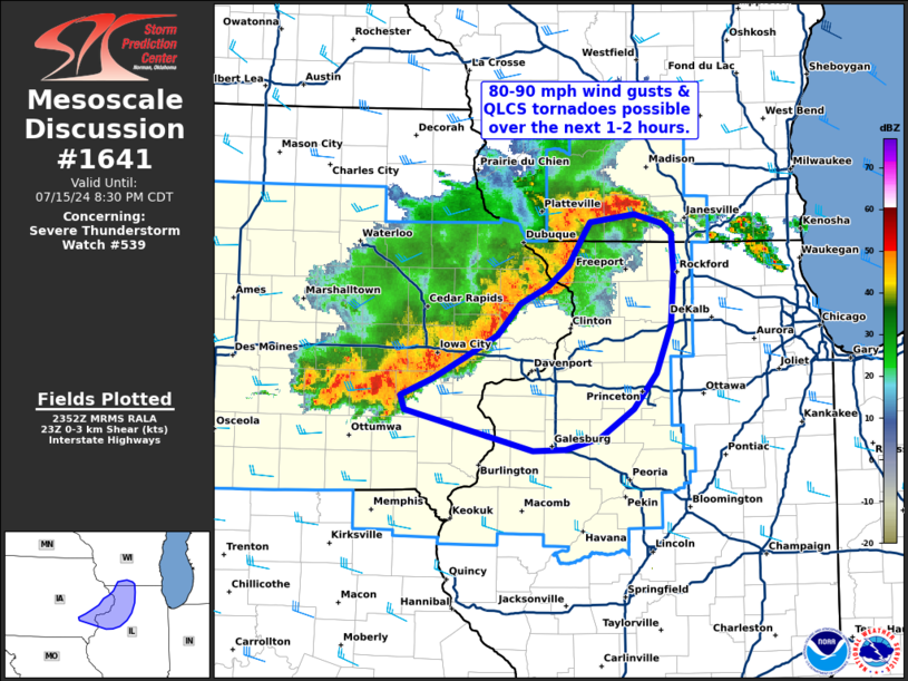
FOR ADDITIONAL INFORMATION SEE MESOSCALE DISCUSSION 1641
..MOORE..07/16/24
ATTN...WFO...DMX...ARX...DVN...ILX...LOT...MKX...
&&
STATUS REPORT FOR WS 539
SEVERE WEATHER THREAT CONTINUES FOR THE FOLLOWING AREAS
ILC067-071-085-109-131-187-160140-
IL
. ILLINOIS COUNTIES INCLUDED ARE
HANCOCK HENDERSON JO DAVIESS
MCDONOUGH MERCER WARREN
$$
IAC031-051-057-087-097-101-111-115-139-177-179-183-160140-
IA
. IOWA COUNTIES INCLUDED ARE
CEDAR DAVIS DES MOINES
HENRY JACKSON JEFFERSON
LEE LOUISA MUSCATINE
VAN BUREN WAPELLO WASHINGTON
$$
MOC045-199-160140-
MO
. MISSOURI COUNTIES INCLUDED ARE
CLARK SCOTLAND
$$
WIC025-055-065-079-133-160140-
WI
. WISCONSIN COUNTIES INCLUDED ARE
DANE JEFFERSON LAFAYETTE
MILWAUKEE WAUKESHA
$$
LMZ645-160140-
CW
. ADJACENT COASTAL WATERS INCLUDED ARE
LMZ645
$$
THE WATCH STATUS MESSAGE IS FOR GUIDANCE PURPOSES ONLY. PLEASE
REFER TO WATCH COUNTY NOTIFICATION STATEMENTS FOR OFFICIAL
INFORMATION ON COUNTIES...INDEPENDENT CITIES AND MARINE ZONES
CLEARED FROM SEVERE THUNDERSTORM AND TORNADO WATCHES.
$$
STATUS REPORT #2 ON WW 539
VALID 152345Z - 160040Z
SEVERE WEATHER THREAT CONTINUES RIGHT OF A LINE FROM 40 NE SDA TO
10 N OXV TO 15 WNW CID TO 20 N DBQ TO 20 SE VOK.
FOR ADDITIONAL INFORMATION SEE MESOSCALE DISCUSSION 1638
..MOORE..07/15/24
ATTN...WFO...DMX...ARX...DVN...ILX...LOT...MKX...
&&
STATUS REPORT FOR WS 539
SEVERE WEATHER THREAT CONTINUES FOR THE FOLLOWING AREAS
ILC011-015-057-067-071-073-085-095-103-109-123-125-131-141-143-
155-161-175-177-179-187-195-201-203-160040-
IL
. ILLINOIS COUNTIES INCLUDED ARE
BUREAU CARROLL FULTON
HANCOCK HENDERSON HENRY
JO DAVIESS KNOX LEE
MCDONOUGH MARSHALL MASON
MERCER OGLE PEORIA
PUTNAM ROCK ISLAND STARK
STEPHENSON TAZEWELL WARREN
WHITESIDE WINNEBAGO WOODFORD
$$
IAC007-031-039-045-051-053-057-061-087-095-097-101-103-105-107-
111-113-115-117-121-123-125-135-139-157-163-177-179-181-183-185-
160040-
IA
. IOWA COUNTIES INCLUDED ARE
APPANOOSE CEDAR CLARKE
CLINTON DAVIS DECATUR
DES MOINES DUBUQUE HENRY
IOWA JACKSON JEFFERSON
JOHNSON JONES KEOKUK
LEE LINN LOUISA
LUCAS MADISON MAHASKA
MARION MONROE MUSCATINE
POWESHIEK SCOTT VAN BUREN
WAPELLO WARREN WASHINGTON
WAYNE
$$
MOC045-199-160040-
MO
. MISSOURI COUNTIES INCLUDED ARE
CLARK SCOTLAND
$$
WIC021-025-045-049-065-105-111-160040-
WI
. WISCONSIN COUNTIES INCLUDED ARE
COLUMBIA DANE GREEN
IOWA LAFAYETTE ROCK
SAUK
$$
THE WATCH STATUS MESSAGE IS FOR GUIDANCE PURPOSES ONLY. PLEASE
REFER TO WATCH COUNTY NOTIFICATION STATEMENTS FOR OFFICIAL
INFORMATION ON COUNTIES...INDEPENDENT CITIES AND MARINE ZONES
CLEARED FROM SEVERE THUNDERSTORM AND TORNADO WATCHES.
$$
STATUS REPORT #1 ON WW 539
VALID 152245Z - 152340Z
SEVERE WEATHER THREAT CONTINUES RIGHT OF A LINE FROM 30 E OMA TO
40 WSW ALO TO 30 NW ALO TO 20 SW LSE.
FOR ADDITIONAL INFORMATION SEE MESOSCALE DISCUSSION 1638
..MOORE..07/15/24
ATTN...WFO...DMX...ARX...DVN...ILX...LOT...MKX...
&&
STATUS REPORT FOR WS 539
SEVERE WEATHER THREAT CONTINUES FOR THE FOLLOWING AREAS
ILC011-015-057-067-071-073-085-095-103-109-123-125-131-141-143-
155-161-175-177-179-187-195-201-203-152340-
IL
. ILLINOIS COUNTIES INCLUDED ARE
BUREAU CARROLL FULTON
HANCOCK HENDERSON HENRY
JO DAVIESS KNOX LEE
MCDONOUGH MARSHALL MASON
MERCER OGLE PEORIA
PUTNAM ROCK ISLAND STARK
STEPHENSON TAZEWELL WARREN
WHITESIDE WINNEBAGO WOODFORD
$$
IAC001-005-007-011-013-015-017-019-023-031-037-039-043-045-049-
051-053-055-057-061-065-075-077-087-095-097-099-101-103-105-107-
111-113-115-117-121-123-125-127-135-139-153-157-163-169-171-177-
179-181-183-185-191-152340-
IA
. IOWA COUNTIES INCLUDED ARE
ADAIR ALLAMAKEE APPANOOSE
BENTON BLACK HAWK BOONE
BREMER BUCHANAN BUTLER
CEDAR CHICKASAW CLARKE
CLAYTON CLINTON DALLAS
DAVIS DECATUR DELAWARE
DES MOINES DUBUQUE FAYETTE
GRUNDY GUTHRIE HENRY
IOWA JACKSON JASPER
JEFFERSON JOHNSON JONES
KEOKUK LEE LINN
LOUISA LUCAS MADISON
MAHASKA MARION MARSHALL
MONROE MUSCATINE POLK
POWESHIEK SCOTT STORY
TAMA VAN BUREN WAPELLO
WARREN WASHINGTON WAYNE
WINNESHIEK
$$
MOC045-199-152340-
MO
. MISSOURI COUNTIES INCLUDED ARE
CLARK SCOTLAND
$$
WIC021-023-025-043-045-049-065-103-105-111-152340-
WI
. WISCONSIN COUNTIES INCLUDED ARE
COLUMBIA CRAWFORD DANE
GRANT GREEN IOWA
LAFAYETTE RICHLAND ROCK
SAUK
$$
THE WATCH STATUS MESSAGE IS FOR GUIDANCE PURPOSES ONLY. PLEASE
REFER TO WATCH COUNTY NOTIFICATION STATEMENTS FOR OFFICIAL
INFORMATION ON COUNTIES...INDEPENDENT CITIES AND MARINE ZONES
CLEARED FROM SEVERE THUNDERSTORM AND TORNADO WATCHES.
$$
Note:
Click for Complete Product Text.
Tornadoes
Probability of 2 or more tornadoes
|
Low (20%)
|
Probability of 1 or more strong (EF2-EF5) tornadoes
|
Low (10%)
|
Wind
Probability of 10 or more severe wind events
|
High (80%)
|
Probability of 1 or more wind events > 65 knots
|
High (70%)
|
Hail
Probability of 10 or more severe hail events
|
Mod (60%)
|
Probability of 1 or more hailstones > 2 inches
|
Mod (30%)
|
Combined Severe Hail/Wind
Probability of 6 or more combined severe hail/wind events
|
High (>95%)
|
For each watch, probabilities for particular events inside the watch
(listed above in each table) are determined by the issuing forecaster.
The "Low" category contains probability values ranging from less than 2%
to 20% (EF2-EF5 tornadoes), less than 5% to 20% (all other probabilities),
"Moderate" from 30% to 60%, and "High" from 70% to greater than 95%.
High values are bolded and lighter in color to provide awareness of
an increased threat for a particular event.


 @NWSSPC