Note:
The expiration time in the watch graphic is amended if the watch is
replaced, cancelled or extended.
Note:
Note:
The expiration time in the watch graphic is amended if the watch is
replaced, cancelled or extended.
Note: Click for
Watch Status Reports.
SEL0
URGENT - IMMEDIATE BROADCAST REQUESTED
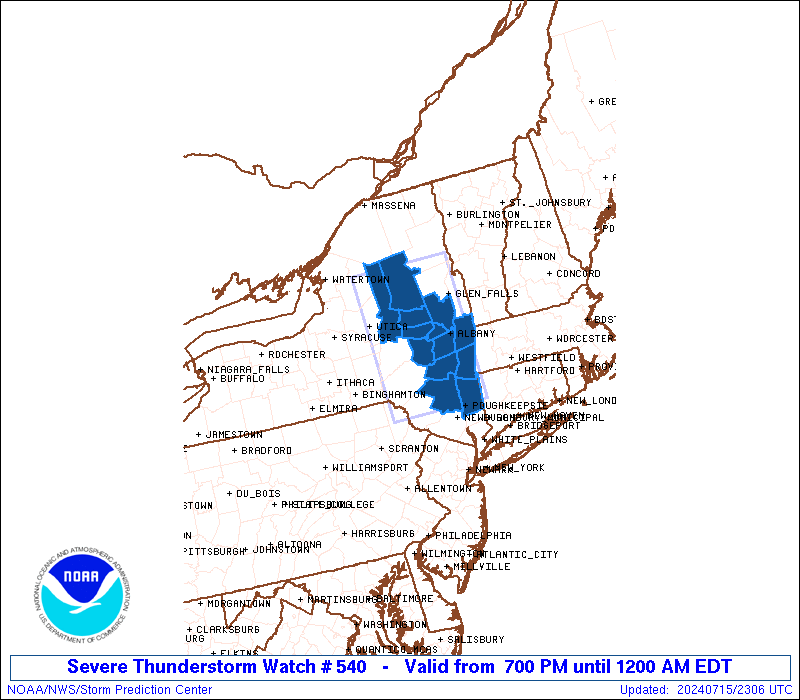
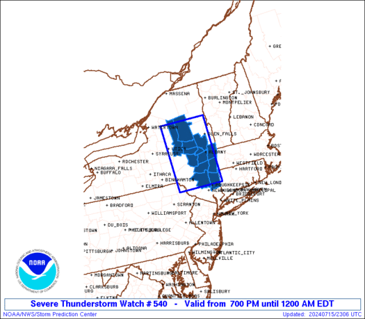
Severe Thunderstorm Watch Number 540
NWS Storm Prediction Center Norman OK
700 PM EDT Mon Jul 15 2024
The NWS Storm Prediction Center has issued a
* Severe Thunderstorm Watch for portions of
Eastern New York
* Effective this Monday night from 700 PM until Midnight EDT.
* Primary threats include...
Scattered damaging wind gusts to 70 mph possible
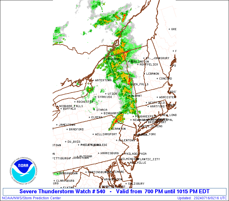
SUMMARY...An organized line of storms will continue eastward through
early tonight into eastern New York, with a continued threat for
damaging gusts.
The severe thunderstorm watch area is approximately along and 50
statute miles east and west of a line from 60 miles northwest of
Glens Falls NY to 80 miles south southwest of Albany NY. For a
complete depiction of the watch see the associated watch outline
update (WOUS64 KWNS WOU0).
PRECAUTIONARY/PREPAREDNESS ACTIONS...
REMEMBER...A Severe Thunderstorm Watch means conditions are
favorable for severe thunderstorms in and close to the watch area.
Persons in these areas should be on the lookout for threatening
weather conditions and listen for later statements and possible
warnings. Severe thunderstorms can and occasionally do produce
tornadoes.
&&
OTHER WATCH INFORMATION...CONTINUE...WW 538...WW 539...
AVIATION...A few severe thunderstorms with hail surface and aloft to
0.5 inches. Extreme turbulence and surface wind gusts to 60 knots. A
few cumulonimbi with maximum tops to 500. Mean storm motion vector
26035.
...Thompson

   SEL0

   URGENT - IMMEDIATE BROADCAST REQUESTED
   Severe Thunderstorm Watch Number 540
   NWS Storm Prediction Center Norman OK
   700 PM EDT Mon Jul 15 2024

   The NWS Storm Prediction Center has issued a

   * Severe Thunderstorm Watch for portions of
     Eastern New York

   * Effective this Monday night from 700 PM until Midnight EDT.

   * Primary threats include...
     Scattered damaging wind gusts to 70 mph possible

   SUMMARY...An organized line of storms will continue eastward through
   early tonight into eastern New York, with a continued threat for
   damaging gusts.

   The severe thunderstorm watch area is approximately along and 50
   statute miles east and west of a line from 60 miles northwest of
   Glens Falls NY to 80 miles south southwest of Albany NY. For a
   complete depiction of the watch see the associated watch outline
   update (WOUS64 KWNS WOU0).

   PRECAUTIONARY/PREPAREDNESS ACTIONS...

   REMEMBER...A Severe Thunderstorm Watch means conditions are
   favorable for severe thunderstorms in and close to the watch area.
   Persons in these areas should be on the lookout for threatening
   weather conditions and listen for later statements and possible
   warnings. Severe thunderstorms can and occasionally do produce
   tornadoes.

   &&

   OTHER WATCH INFORMATION...CONTINUE...WW 538...WW 539...

   AVIATION...A few severe thunderstorms with hail surface and aloft to
   0.5 inches. Extreme turbulence and surface wind gusts to 60 knots. A
   few cumulonimbi with maximum tops to 500. Mean storm motion vector
   26035.

   ...Thompson
 Note:
The Aviation Watch (SAW) product is an approximation to the watch area.
The actual watch is depicted by the shaded areas.
Note:
The Aviation Watch (SAW) product is an approximation to the watch area.
The actual watch is depicted by the shaded areas.
   SAW0
   WW 540 SEVERE TSTM NY 152300Z - 160400Z
   AXIS..50 STATUTE MILES EAST AND WEST OF LINE..
   60NW GFL/GLENS FALLS NY/ - 80SSW ALB/ALBANY NY/
   ..AVIATION COORDS.. 45NM E/W /59S MSS - 37N SAX/
   HAIL SURFACE AND ALOFT..0.5 INCH. WIND GUSTS..60 KNOTS.
   MAX TOPS TO 500. MEAN STORM MOTION VECTOR 26035.

   LAT...LON 43947347 41677342 41677536 43947548

   THIS IS AN APPROXIMATION TO THE WATCH AREA.  FOR A
   COMPLETE DEPICTION OF THE WATCH SEE WOUS64 KWNS
   FOR WOU0.
Watch 540 Status Report Messages:
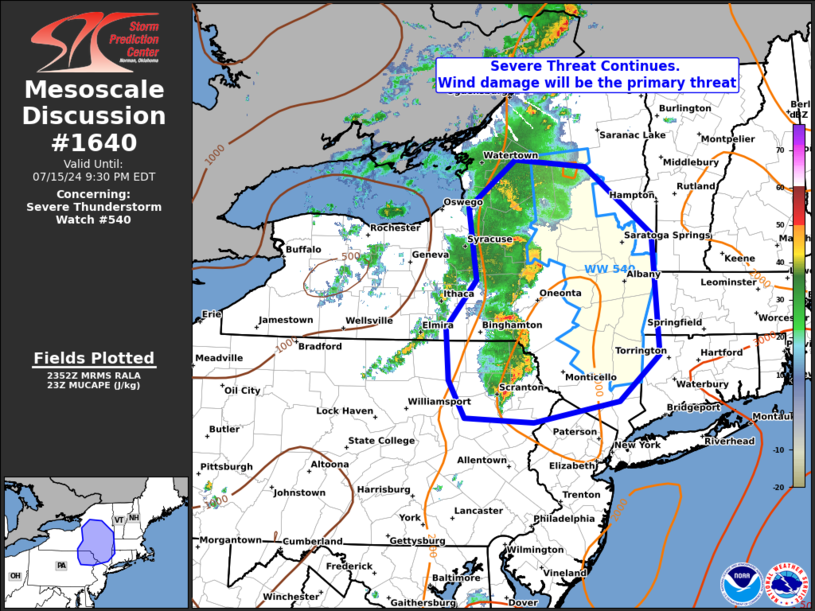
STATUS REPORT #2 ON WW 540

VALID 160130Z - 160240Z

SEVERE WEATHER THREAT CONTINUES RIGHT OF A LINE FROM 25 NNW AVP
TO 45 NE MSV TO 20 W ALB TO 45 ENE UCA TO 30 ENE ART.

FOR ADDITIONAL INFORMATION SEE MESOSCALE DISCUSSION 1640

..MOORE..07/16/24

ATTN...WFO...ALY...

&&

STATUS REPORT FOR WS 540

SEVERE WEATHER THREAT CONTINUES FOR THE FOLLOWING AREAS

NYC001-021-027-039-041-083-091-093-111-160240-

NY
.    NEW YORK COUNTIES INCLUDED ARE

ALBANY		     COLUMBIA		 DUTCHESS
GREENE		     HAMILTON		 RENSSELAER
SARATOGA	     SCHENECTADY	 ULSTER
$$


THE WATCH STATUS MESSAGE IS FOR GUIDANCE PURPOSES ONLY.  PLEASE
REFER TO WATCH COUNTY NOTIFICATION STATEMENTS FOR OFFICIAL
INFORMATION ON COUNTIES...INDEPENDENT CITIES AND MARINE ZONES
CLEARED FROM SEVERE THUNDERSTORM AND TORNADO WATCHES.
$$

STATUS REPORT #1 ON WW 540

VALID 160040Z - 160140Z

THE SEVERE WEATHER THREAT CONTINUES ACROSS THE ENTIRE WATCH AREA.

FOR ADDITIONAL INFORMATION SEE MESOSCALE DISCUSSION 1640

..MOORE..07/16/24

ATTN...WFO...ALY...

&&

STATUS REPORT FOR WS 540

SEVERE WEATHER THREAT CONTINUES FOR THE FOLLOWING AREAS

NYC001-021-027-035-039-041-043-057-083-091-093-095-111-160140-

NY
.    NEW YORK COUNTIES INCLUDED ARE

ALBANY		     COLUMBIA		 DUTCHESS
FULTON		     GREENE		 HAMILTON
HERKIMER	     MONTGOMERY 	 RENSSELAER
SARATOGA	     SCHENECTADY	 SCHOHARIE
ULSTER
$$


THE WATCH STATUS MESSAGE IS FOR GUIDANCE PURPOSES ONLY.  PLEASE
REFER TO WATCH COUNTY NOTIFICATION STATEMENTS FOR OFFICIAL
INFORMATION ON COUNTIES...INDEPENDENT CITIES AND MARINE ZONES
CLEARED FROM SEVERE THUNDERSTORM AND TORNADO WATCHES.
$$
Note:
Click for Complete Product Text.
Tornadoes
Probability of 2 or more tornadoes
|
Low (10%)
|
Probability of 1 or more strong (EF2-EF5) tornadoes
|
Low (<2%)
|
Wind
Probability of 10 or more severe wind events
|
Mod (40%)
|
Probability of 1 or more wind events > 65 knots
|
Low (20%)
|
Hail
Probability of 10 or more severe hail events
|
Low (10%)
|
Probability of 1 or more hailstones > 2 inches
|
Low (<5%)
|
Combined Severe Hail/Wind
Probability of 6 or more combined severe hail/wind events
|
Mod (60%)
|
For each watch, probabilities for particular events inside the watch
(listed above in each table) are determined by the issuing forecaster.
The "Low" category contains probability values ranging from less than 2%
to 20% (EF2-EF5 tornadoes), less than 5% to 20% (all other probabilities),
"Moderate" from 30% to 60%, and "High" from 70% to greater than 95%.
High values are bolded and lighter in color to provide awareness of
an increased threat for a particular event.


 @NWSSPC