 Note:
The expiration time in the watch graphic is amended if the watch is
replaced, cancelled or extended.
Note:
Note:
The expiration time in the watch graphic is amended if the watch is
replaced, cancelled or extended.
Note: Click for
Watch Status Reports.
SEL2
URGENT - IMMEDIATE BROADCAST REQUESTED
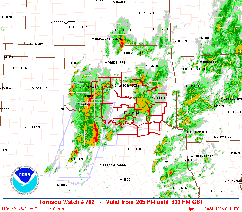
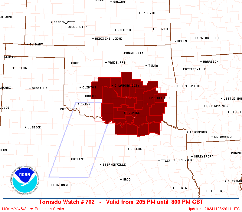
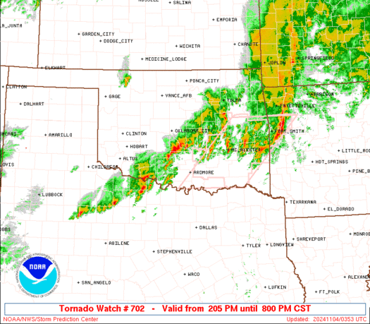
Tornado Watch Number 702
NWS Storm Prediction Center Norman OK
205 PM CST Sun Nov 3 2024
The NWS Storm Prediction Center has issued a
* Tornado Watch for portions of
Central and Southeast Oklahoma
North Texas
* Effective this Sunday afternoon and evening from 205 PM until
800 PM CST.
* Primary threats include...
A few tornadoes likely
Widespread damaging winds likely with isolated significant gusts
to 75 mph possible
Scattered large hail events to 1.5 inches in diameter possible
SUMMARY...Clusters of intense thunderstorms over southwest OK and
northwest TX will track rapidly northeastward this afternoon across
the watch area. Strong low-level shear will support a risk of
tornadoes and damaging wind gusts with these storms.
The tornado watch area is approximately along and 60 statute miles
north and south of a line from 15 miles north northwest of Fort Sill
OK to 45 miles southeast of Mcalester OK. For a complete depiction
of the watch see the associated watch outline update (WOUS64 KWNS
WOU2).
PRECAUTIONARY/PREPAREDNESS ACTIONS...
REMEMBER...A Tornado Watch means conditions are favorable for
tornadoes and severe thunderstorms in and close to the watch
area. Persons in these areas should be on the lookout for
threatening weather conditions and listen for later statements
and possible warnings.
&&
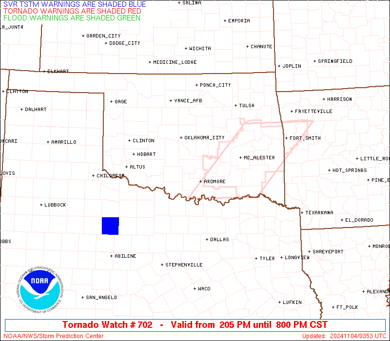
OTHER WATCH INFORMATION...CONTINUE...WW 701...
AVIATION...Tornadoes and a few severe thunderstorms with hail
surface and aloft to 1.5 inches. Extreme turbulence and surface wind
gusts to 65 knots. A few cumulonimbi with maximum tops to 500. Mean
storm motion vector 24035.
...Hart
 Note:
The Aviation Watch (SAW) product is an approximation to the watch area.
The actual watch is depicted by the shaded areas.
Note:
The Aviation Watch (SAW) product is an approximation to the watch area.
The actual watch is depicted by the shaded areas.
   SAW2
   WW 702 TORNADO OK TX 032005Z - 040200Z
   AXIS..60 STATUTE MILES NORTH AND SOUTH OF LINE..
   15NNW FSI/FORT SILL OK/ - 45SE MLC/MCALESTER OK/
   ..AVIATION COORDS.. 50NM N/S /52N SPS - 38SE MLC/
   HAIL SURFACE AND ALOFT..1.5 INCHES. WIND GUSTS..65 KNOTS.
   MAX TOPS TO 500. MEAN STORM MOTION VECTOR 24035.

   LAT...LON 35729850 35299522 33559522 33989850

   THIS IS AN APPROXIMATION TO THE WATCH AREA.  FOR A
   COMPLETE DEPICTION OF THE WATCH SEE WOUS64 KWNS
   FOR WOU2.
Watch 702 Status Report Messages:
STATUS REPORT #3 ON WW 702

VALID 032320Z - 040040Z

SEVERE WEATHER THREAT CONTINUES RIGHT OF A LINE FROM 40 SSW SPS
TO 35 WSW ADM TO 10 SSW ADM TO 45 W MLC TO 40 W MKO.

FOR ADDITIONAL INFORMATION SEE MESOSCALE DISCUSSION 2196

..THORNTON..11/03/24

ATTN...WFO...OUN...TSA...FWD...

&&

STATUS REPORT FOR WT 702

SEVERE WEATHER THREAT CONTINUES FOR THE FOLLOWING AREAS

OKC005-013-023-029-063-069-077-085-091-095-121-123-127-040040-

OK
.    OKLAHOMA COUNTIES INCLUDED ARE

ATOKA		     BRYAN		 CHOCTAW
COAL		     HUGHES		 JOHNSTON
LATIMER 	     LOVE		 MCINTOSH
MARSHALL	     PITTSBURG		 PONTOTOC
PUSHMATAHA
$$


TXC097-147-181-277-040040-

TX
.    TEXAS COUNTIES INCLUDED ARE

COOKE		     FANNIN		 GRAYSON
LAMAR
$$


THE WATCH STATUS MESSAGE IS FOR GUIDANCE PURPOSES ONLY.  PLEASE
REFER TO WATCH COUNTY NOTIFICATION STATEMENTS FOR OFFICIAL
INFORMATION ON COUNTIES...INDEPENDENT CITIES AND MARINE ZONES
CLEARED FROM SEVERE THUNDERSTORM AND TORNADO WATCHES.
$$

STATUS REPORT #2 ON WW 702

VALID 032320Z - 040040Z

SEVERE WEATHER THREAT CONTINUES RIGHT OF A LINE FROM 40 SSW SPS
TO 35 WSW ADM TO 10 SSW ADM TO 45 W MLC TO 40 W MKO.

FOR ADDITIONAL INFORMATION SEE MESOSCALE DISCUSSION 2196

..THORNTON..11/03/24

ATTN...WFO...OUN...TSA...FWD...

&&

STATUS REPORT FOR WT 702

SEVERE WEATHER THREAT CONTINUES FOR THE FOLLOWING AREAS

OKC005-013-023-029-063-069-077-085-091-095-121-123-127-040040-

OK
.    OKLAHOMA COUNTIES INCLUDED ARE

ATOKA		     BRYAN		 CHOCTAW
COAL		     HUGHES		 JOHNSTON
LATIMER 	     LOVE		 MCINTOSH
MARSHALL	     PITTSBURG		 PONTOTOC
PUSHMATAHA
$$


TXC097-147-181-277-040040-

TX
.    TEXAS COUNTIES INCLUDED ARE

COOKE		     FANNIN		 GRAYSON
LAMAR
$$


THE WATCH STATUS MESSAGE IS FOR GUIDANCE PURPOSES ONLY.  PLEASE
REFER TO WATCH COUNTY NOTIFICATION STATEMENTS FOR OFFICIAL
INFORMATION ON COUNTIES...INDEPENDENT CITIES AND MARINE ZONES
CLEARED FROM SEVERE THUNDERSTORM AND TORNADO WATCHES.
$$

STATUS REPORT #1 ON WW 702

VALID 032230Z - 032340Z

SEVERE WEATHER THREAT CONTINUES RIGHT OF A LINE FROM 25 SW SPS TO
35 WNW ADM TO 25 N OKC.

FOR ADDITIONAL INFORMATION SEE MESOSCALE DISCUSSION

..THORNTON..11/03/24

ATTN...WFO...OUN...TSA...FWD...

&&

STATUS REPORT FOR WT 702

SEVERE WEATHER THREAT CONTINUES FOR THE FOLLOWING AREAS

OKC005-013-019-023-027-029-049-063-067-069-077-081-085-087-091-
095-099-107-109-121-123-125-127-133-032340-

OK
.    OKLAHOMA COUNTIES INCLUDED ARE

ATOKA		     BRYAN		 CARTER
CHOCTAW 	     CLEVELAND		 COAL
GARVIN		     HUGHES		 JEFFERSON
JOHNSTON	     LATIMER		 LINCOLN
LOVE		     MCCLAIN		 MCINTOSH
MARSHALL	     MURRAY		 OKFUSKEE
OKLAHOMA	     PITTSBURG		 PONTOTOC
POTTAWATOMIE	     PUSHMATAHA 	 SEMINOLE
$$


TXC097-147-181-277-032340-

TX
.    TEXAS COUNTIES INCLUDED ARE

COOKE		     FANNIN		 GRAYSON
LAMAR
$$


THE WATCH STATUS MESSAGE IS FOR GUIDANCE PURPOSES ONLY.  PLEASE
REFER TO WATCH COUNTY NOTIFICATION STATEMENTS FOR OFFICIAL
INFORMATION ON COUNTIES...INDEPENDENT CITIES AND MARINE ZONES
CLEARED FROM SEVERE THUNDERSTORM AND TORNADO WATCHES.
$$
Note:
Click for Complete Product Text.
Tornadoes
Probability of 2 or more tornadoes
|
High (70%)
|
Probability of 1 or more strong (EF2-EF5) tornadoes
|
Low (20%)
|
Wind
Probability of 10 or more severe wind events
|
High (80%)
|
Probability of 1 or more wind events > 65 knots
|
Mod (30%)
|
Hail
Probability of 10 or more severe hail events
|
Mod (50%)
|
Probability of 1 or more hailstones > 2 inches
|
Low (20%)
|
Combined Severe Hail/Wind
Probability of 6 or more combined severe hail/wind events
|
High (>95%)
|
For each watch, probabilities for particular events inside the watch
(listed above in each table) are determined by the issuing forecaster.
The "Low" category contains probability values ranging from less than 2%
to 20% (EF2-EF5 tornadoes), less than 5% to 20% (all other probabilities),
"Moderate" from 30% to 60%, and "High" from 70% to greater than 95%.
High values are bolded and lighter in color to provide awareness of
an increased threat for a particular event.


 @NWSSPC