 Note:
The expiration time in the watch graphic is amended if the watch is
replaced, cancelled or extended.
Note:
Note:
The expiration time in the watch graphic is amended if the watch is
replaced, cancelled or extended.
Note: Click for
Watch Status Reports.
SEL1
URGENT - IMMEDIATE BROADCAST REQUESTED
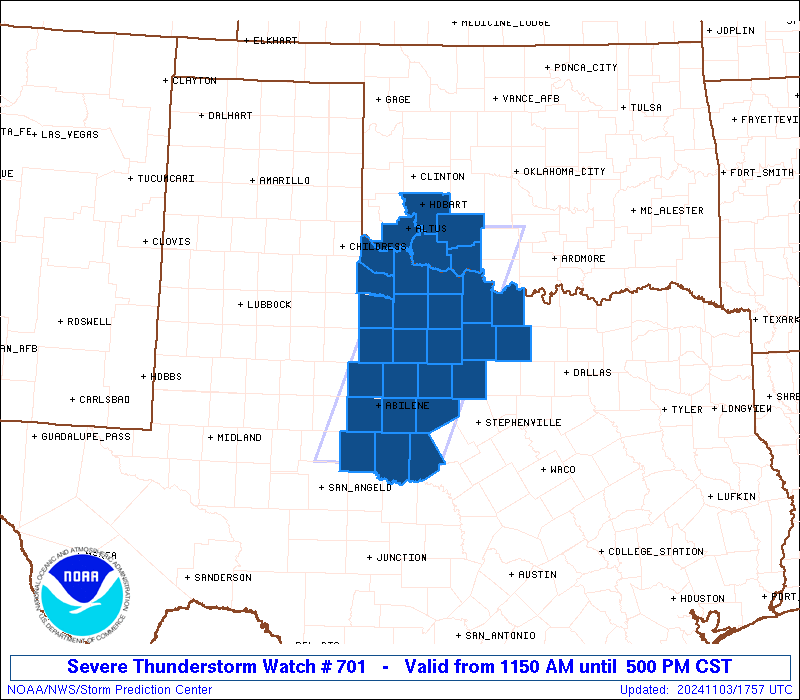
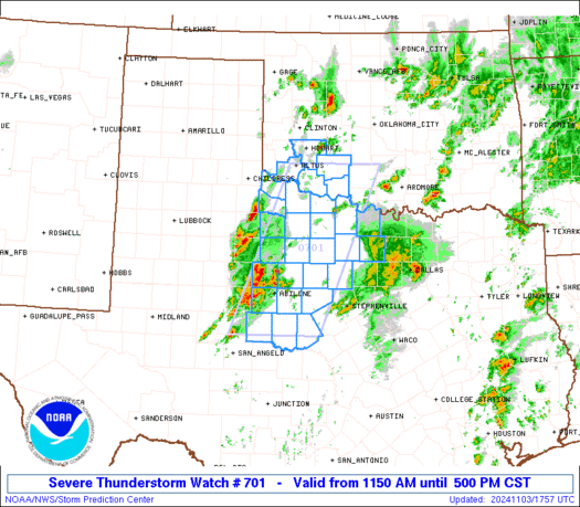
Severe Thunderstorm Watch Number 701
NWS Storm Prediction Center Norman OK
1150 AM CST Sun Nov 3 2024
The NWS Storm Prediction Center has issued a
* Severe Thunderstorm Watch for portions of
Southwest Oklahoma
Northwest Texas
* Effective this Sunday morning and afternoon from 1150 AM until
500 PM CST.
* Primary threats include...
Scattered large hail and isolated very large hail events to 2
inches in diameter likely
Scattered damaging wind gusts to 70 mph likely
A tornado or two possible
SUMMARY...Thunderstorms are intensifying over northwest TX, in a
moist and unstable environment. These storms will pose a risk of
large hail and damaging winds, with an increasing risk of a tornado
or two by late afternoon.
The severe thunderstorm watch area is approximately along and 55
statute miles east and west of a line from 50 miles south of Abilene
TX to 5 miles north northwest of Fort Sill OK. For a complete
depiction of the watch see the associated watch outline update
(WOUS64 KWNS WOU1).
PRECAUTIONARY/PREPAREDNESS ACTIONS...
REMEMBER...A Severe Thunderstorm Watch means conditions are
favorable for severe thunderstorms in and close to the watch area.
Persons in these areas should be on the lookout for threatening
weather conditions and listen for later statements and possible
warnings. Severe thunderstorms can and occasionally do produce
tornadoes.
&&
AVIATION...A few severe thunderstorms with hail surface and aloft to
2 inches. Extreme turbulence and surface wind gusts to 60 knots. A
few cumulonimbi with maximum tops to 500. Mean storm motion vector
24030.
...Hart
   SEL1

   URGENT - IMMEDIATE BROADCAST REQUESTED
   Severe Thunderstorm Watch Number 701
   NWS Storm Prediction Center Norman OK
   1150 AM CST Sun Nov 3 2024

   The NWS Storm Prediction Center has issued a

   * Severe Thunderstorm Watch for portions of
     Southwest Oklahoma
     Northwest Texas

   * Effective this Sunday morning and afternoon from 1150 AM until
     500 PM CST.

   * Primary threats include...
     Scattered large hail and isolated very large hail events to 2
       inches in diameter likely
     Scattered damaging wind gusts to 70 mph likely
     A tornado or two possible

   SUMMARY...Thunderstorms are intensifying over northwest TX, in a
   moist and unstable environment.  These storms will pose a risk of
   large hail and damaging winds, with an increasing risk of a tornado
   or two by late afternoon.

   The severe thunderstorm watch area is approximately along and 55
   statute miles east and west of a line from 50 miles south of Abilene
   TX to 5 miles north northwest of Fort Sill OK. For a complete
   depiction of the watch see the associated watch outline update
   (WOUS64 KWNS WOU1).

   PRECAUTIONARY/PREPAREDNESS ACTIONS...

   REMEMBER...A Severe Thunderstorm Watch means conditions are
   favorable for severe thunderstorms in and close to the watch area.
   Persons in these areas should be on the lookout for threatening
   weather conditions and listen for later statements and possible
   warnings. Severe thunderstorms can and occasionally do produce
   tornadoes.

   &&

   AVIATION...A few severe thunderstorms with hail surface and aloft to
   2 inches. Extreme turbulence and surface wind gusts to 60 knots. A
   few cumulonimbi with maximum tops to 500. Mean storm motion vector
   24030.

   ...Hart
 Note:
The Aviation Watch (SAW) product is an approximation to the watch area.
The actual watch is depicted by the shaded areas.
Note:
The Aviation Watch (SAW) product is an approximation to the watch area.
The actual watch is depicted by the shaded areas.
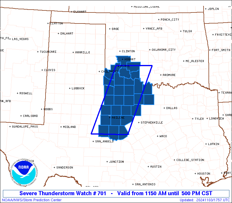
   SAW1
   WW 701 SEVERE TSTM OK TX 031750Z - 032300Z
   AXIS..55 STATUTE MILES EAST AND WEST OF LINE..
   50S ABI/ABILENE TX/ - 5NNW FSI/FORT SILL OK/
   ..AVIATION COORDS.. 50NM E/W /44ENE SJT - 44N SPS/
   HAIL SURFACE AND ALOFT..2 INCHES. WIND GUSTS..60 KNOTS.
   MAX TOPS TO 500. MEAN STORM MOTION VECTOR 24030.

   LAT...LON 31690062 34719940 34719747 31699874

   THIS IS AN APPROXIMATION TO THE WATCH AREA.  FOR A
   COMPLETE DEPICTION OF THE WATCH SEE WOUS64 KWNS
   FOR WOU1.
Watch 701 Status Report Messages:
STATUS REPORT #3 ON WW 701

VALID 032145Z - 032240Z

SEVERE WEATHER THREAT CONTINUES RIGHT OF A LINE FROM 55 W ABI TO
20 S SPS TO 25 SSE FSI TO 30 NNE CSM.

FOR ADDITIONAL INFORMATION SEE MESOSCALE DISCUSSION 2195

..MOORE..11/03/24

ATTN...WFO...OUN...SJT...FWD...

&&

STATUS REPORT FOR WS 701

SEVERE WEATHER THREAT CONTINUES FOR THE FOLLOWING AREAS

TXC049-059-077-083-133-237-253-337-363-399-417-429-441-447-497-
503-032240-

TX
.    TEXAS COUNTIES INCLUDED ARE

BROWN		     CALLAHAN		 CLAY
COLEMAN 	     EASTLAND		 JACK
JONES		     MONTAGUE		 PALO PINTO
RUNNELS 	     SHACKELFORD	 STEPHENS
TAYLOR		     THROCKMORTON	 WISE
YOUNG
$$


THE WATCH STATUS MESSAGE IS FOR GUIDANCE PURPOSES ONLY.  PLEASE
REFER TO WATCH COUNTY NOTIFICATION STATEMENTS FOR OFFICIAL
INFORMATION ON COUNTIES...INDEPENDENT CITIES AND MARINE ZONES
CLEARED FROM SEVERE THUNDERSTORM AND TORNADO WATCHES.
$$

STATUS REPORT #2 ON WW 701

VALID 032045Z - 032140Z

SEVERE WEATHER THREAT CONTINUES RIGHT OF A LINE FROM 50 W ABI TO
45 SW SPS TO 10 ESE LTS TO 50 W CSM.

FOR ADDITIONAL INFORMATION SEE MESOSCALE DISCUSSION 2191

..MOORE..11/03/24

ATTN...WFO...OUN...SJT...FWD...

&&

STATUS REPORT FOR WS 701

SEVERE WEATHER THREAT CONTINUES FOR THE FOLLOWING AREAS

OKC009-031-033-055-075-141-149-032140-

OK
.    OKLAHOMA COUNTIES INCLUDED ARE

BECKHAM 	     COMANCHE		 COTTON
GREER		     KIOWA		 TILLMAN
WASHITA
$$


TXC009-049-059-077-083-133-237-253-337-363-399-417-429-441-447-
485-497-503-032140-

TX
.    TEXAS COUNTIES INCLUDED ARE

ARCHER		     BROWN		 CALLAHAN
CLAY		     COLEMAN		 EASTLAND
JACK		     JONES		 MONTAGUE
PALO PINTO	     RUNNELS		 SHACKELFORD
STEPHENS	     TAYLOR		 THROCKMORTON
WICHITA 	     WISE		 YOUNG
$$


THE WATCH STATUS MESSAGE IS FOR GUIDANCE PURPOSES ONLY.  PLEASE
REFER TO WATCH COUNTY NOTIFICATION STATEMENTS FOR OFFICIAL
INFORMATION ON COUNTIES...INDEPENDENT CITIES AND MARINE ZONES
CLEARED FROM SEVERE THUNDERSTORM AND TORNADO WATCHES.
$$

STATUS REPORT #1 ON WW 701

VALID 031935Z - 032040Z

THE SEVERE WEATHER THREAT CONTINUES ACROSS THE ENTIRE WATCH AREA.

FOR ADDITIONAL INFORMATION SEE MESOSCALE DISCUSSION 2191

..MOORE..11/03/24

ATTN...WFO...OUN...SJT...FWD...

&&

STATUS REPORT FOR WS 701

SEVERE WEATHER THREAT CONTINUES FOR THE FOLLOWING AREAS

OKC031-033-065-075-141-032040-

OK
.    OKLAHOMA COUNTIES INCLUDED ARE

COMANCHE	     COTTON		 JACKSON
KIOWA		     TILLMAN
$$


TXC009-023-049-059-077-083-133-155-197-207-237-253-275-337-363-
399-417-429-441-447-485-487-497-503-032040-

TX
.    TEXAS COUNTIES INCLUDED ARE

ARCHER		     BAYLOR		 BROWN
CALLAHAN	     CLAY		 COLEMAN
EASTLAND	     FOARD		 HARDEMAN
HASKELL 	     JACK		 JONES
KNOX		     MONTAGUE		 PALO PINTO
RUNNELS 	     SHACKELFORD	 STEPHENS
TAYLOR		     THROCKMORTON	 WICHITA
WILBARGER	     WISE		 YOUNG
$$


THE WATCH STATUS MESSAGE IS FOR GUIDANCE PURPOSES ONLY.  PLEASE
REFER TO WATCH COUNTY NOTIFICATION STATEMENTS FOR OFFICIAL
INFORMATION ON COUNTIES...INDEPENDENT CITIES AND MARINE ZONES
CLEARED FROM SEVERE THUNDERSTORM AND TORNADO WATCHES.
$$
Note:
Click for Complete Product Text.
Tornadoes
Probability of 2 or more tornadoes
|
Low (20%)
|
Probability of 1 or more strong (EF2-EF5) tornadoes
|
Low (10%)
|
Wind
Probability of 10 or more severe wind events
|
Mod (60%)
|
Probability of 1 or more wind events > 65 knots
|
Low (20%)
|
Hail
Probability of 10 or more severe hail events
|
Mod (60%)
|
Probability of 1 or more hailstones > 2 inches
|
Mod (60%)
|
Combined Severe Hail/Wind
Probability of 6 or more combined severe hail/wind events
|
High (>95%)
|
For each watch, probabilities for particular events inside the watch
(listed above in each table) are determined by the issuing forecaster.
The "Low" category contains probability values ranging from less than 2%
to 20% (EF2-EF5 tornadoes), less than 5% to 20% (all other probabilities),
"Moderate" from 30% to 60%, and "High" from 70% to greater than 95%.
High values are bolded and lighter in color to provide awareness of
an increased threat for a particular event.


 @NWSSPC