 Note:
The expiration time in the watch graphic is amended if the watch is
replaced, cancelled or extended.
Note:
Note:
The expiration time in the watch graphic is amended if the watch is
replaced, cancelled or extended.
Note: Click for
Watch Status Reports.
SEL5
URGENT - IMMEDIATE BROADCAST REQUESTED
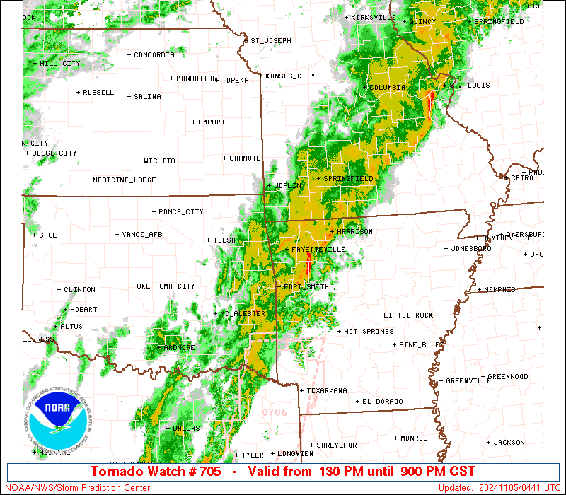
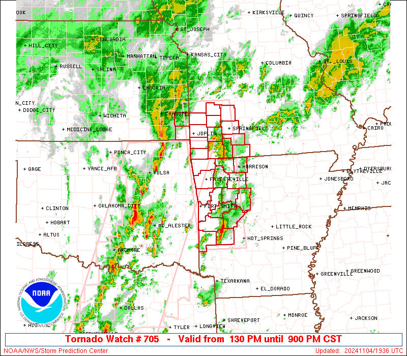
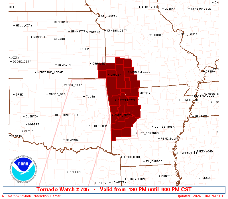
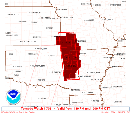
Tornado Watch Number 705
NWS Storm Prediction Center Norman OK
130 PM CST Mon Nov 4 2024
The NWS Storm Prediction Center has issued a
* Tornado Watch for portions of
Western Arkansas
Extreme southeast Kansas
Southwest Missouri
* Effective this Monday afternoon and evening from 130 PM until
900 PM CST.
* Primary threats include...
A few tornadoes likely with a couple intense tornadoes possible
Scattered damaging wind gusts to 70 mph likely
Isolated large hail events to 1.5 inches in diameter possible
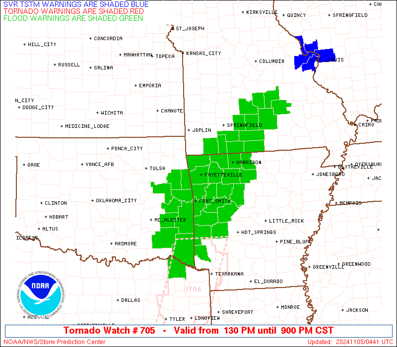
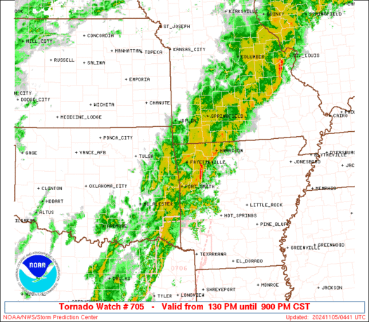
SUMMARY...Multiple rounds of thunderstorms will affect the watch
area this afternoon and evening. Strong winds aloft and a
warm/moist environment will pose a risk of severe storms capable of
damaging winds and a few tornadoes.
The tornado watch area is approximately along and 40 statute miles
east and west of a line from 60 miles north northeast of Joplin MO
to 40 miles west southwest of Hot Springs AR. For a complete
depiction of the watch see the associated watch outline update
(WOUS64 KWNS WOU5).
PRECAUTIONARY/PREPAREDNESS ACTIONS...
REMEMBER...A Tornado Watch means conditions are favorable for
tornadoes and severe thunderstorms in and close to the watch
area. Persons in these areas should be on the lookout for
threatening weather conditions and listen for later statements
and possible warnings.
&&
OTHER WATCH INFORMATION...CONTINUE...WW 704...
AVIATION...Tornadoes and a few severe thunderstorms with hail
surface and aloft to 1.5 inches. Extreme turbulence and surface wind
gusts to 60 knots. A few cumulonimbi with maximum tops to 500. Mean
storm motion vector 24035.
...Hart
 Note:
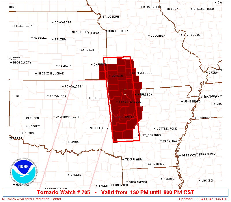
The Aviation Watch (SAW) product is an approximation to the watch area.
The actual watch is depicted by the shaded areas.
Note:
The Aviation Watch (SAW) product is an approximation to the watch area.
The actual watch is depicted by the shaded areas.
   SAW5
   WW 705 TORNADO AR KS MO 041930Z - 050300Z
   AXIS..40 STATUTE MILES EAST AND WEST OF LINE..
   60NNE JLN/JOPLIN MO/ - 40WSW HOT/HOT SPRINGS AR/
   ..AVIATION COORDS.. 35NM E/W /27SE BUM - 47NNE TXK/
   HAIL SURFACE AND ALOFT..1.5 INCHES. WIND GUSTS..60 KNOTS.
   MAX TOPS TO 500. MEAN STORM MOTION VECTOR 24035.

   LAT...LON 37959334 34249305 34249445 37959481

   THIS IS AN APPROXIMATION TO THE WATCH AREA.  FOR A
   COMPLETE DEPICTION OF THE WATCH SEE WOUS64 KWNS
   FOR WOU5.
Watch 705 Status Report Messages:
STATUS REPORT #4 ON WW 705
VALID 050120Z - 050240Z
SEVERE WEATHER THREAT CONTINUES RIGHT OF A LINE FROM 30 WNW FSM
TO 25 SSE SGF TO 25 NNE SGF.
..WEINMAN..11/05/24
ATTN...WFO...TSA...LZK...SGF...
&&
STATUS REPORT FOR WT 705
SEVERE WEATHER THREAT CONTINUES FOR THE FOLLOWING AREAS
ARC005-009-015-033-047-071-083-087-089-097-101-109-113-115-127-
129-131-143-149-050240-
AR
. ARKANSAS COUNTIES INCLUDED ARE
BAXTER BOONE CARROLL
CRAWFORD FRANKLIN JOHNSON
LOGAN MADISON MARION
MONTGOMERY NEWTON PIKE
POLK POPE SCOTT
SEARCY SEBASTIAN WASHINGTON
YELL
$$
MOC043-067-091-153-209-213-215-225-229-050240-
MO
. MISSOURI COUNTIES INCLUDED ARE
CHRISTIAN DOUGLAS HOWELL
OZARK STONE TANEY
TEXAS WEBSTER WRIGHT
$$
THE WATCH STATUS MESSAGE IS FOR GUIDANCE PURPOSES ONLY. PLEASE
REFER TO WATCH COUNTY NOTIFICATION STATEMENTS FOR OFFICIAL
INFORMATION ON COUNTIES...INDEPENDENT CITIES AND MARINE ZONES
CLEARED FROM SEVERE THUNDERSTORM AND TORNADO WATCHES.
$$
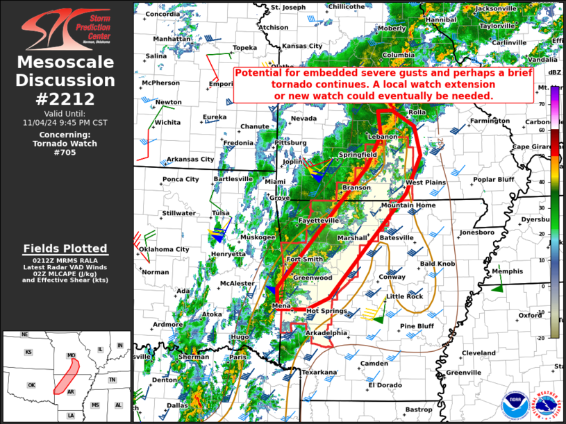
STATUS REPORT #3 ON WW 705
VALID 050020Z - 050140Z
SEVERE WEATHER THREAT CONTINUES RIGHT OF A LINE FROM 35 WSW FYV
TO 30 NNE FYV TO 40 SSE SZL.
FOR ADDITIONAL INFORMATION SEE MESOSCALE DISCUSSION 2210
..WEINMAN..11/05/24
ATTN...WFO...TSA...LZK...SGF...
&&
STATUS REPORT FOR WT 705
SEVERE WEATHER THREAT CONTINUES FOR THE FOLLOWING AREAS
ARC009-015-033-047-071-083-087-089-097-101-109-113-115-127-129-
131-143-149-050140-
AR
. ARKANSAS COUNTIES INCLUDED ARE
BOONE CARROLL CRAWFORD
FRANKLIN JOHNSON LOGAN
MADISON MARION MONTGOMERY
NEWTON PIKE POLK
POPE SCOTT SEARCY
SEBASTIAN WASHINGTON YELL
$$
MOC009-043-067-077-109-153-167-209-213-050140-
MO
. MISSOURI COUNTIES INCLUDED ARE
BARRY CHRISTIAN DOUGLAS
GREENE LAWRENCE OZARK
POLK STONE TANEY
$$
THE WATCH STATUS MESSAGE IS FOR GUIDANCE PURPOSES ONLY. PLEASE
REFER TO WATCH COUNTY NOTIFICATION STATEMENTS FOR OFFICIAL
INFORMATION ON COUNTIES...INDEPENDENT CITIES AND MARINE ZONES
CLEARED FROM SEVERE THUNDERSTORM AND TORNADO WATCHES.
$$
STATUS REPORT #2 ON WW 705
VALID 042145Z - 042240Z
SEVERE WEATHER THREAT CONTINUES RIGHT OF A LINE FROM 20 NW GMJ TO
55 ENE CNU.
FOR ADDITIONAL INFORMATION SEE MESOSCALE DISCUSSION 2207
..MOORE..11/04/24
ATTN...WFO...TSA...LZK...SGF...
&&
STATUS REPORT FOR WT 705
SEVERE WEATHER THREAT CONTINUES FOR THE FOLLOWING AREAS
ARC007-009-015-033-047-071-083-087-097-101-113-115-127-131-143-
149-042240-
AR
. ARKANSAS COUNTIES INCLUDED ARE
BENTON BOONE CARROLL
CRAWFORD FRANKLIN JOHNSON
LOGAN MADISON MONTGOMERY
NEWTON POLK POPE
SCOTT SEBASTIAN WASHINGTON
YELL
$$
MOC009-011-039-043-057-077-097-109-119-145-167-209-213-042240-
MO
. MISSOURI COUNTIES INCLUDED ARE
BARRY BARTON CEDAR
CHRISTIAN DADE GREENE
JASPER LAWRENCE MCDONALD
NEWTON POLK STONE
TANEY
$$
THE WATCH STATUS MESSAGE IS FOR GUIDANCE PURPOSES ONLY. PLEASE
REFER TO WATCH COUNTY NOTIFICATION STATEMENTS FOR OFFICIAL
INFORMATION ON COUNTIES...INDEPENDENT CITIES AND MARINE ZONES
CLEARED FROM SEVERE THUNDERSTORM AND TORNADO WATCHES.
$$
STATUS REPORT #1 ON WW 705
VALID 042050Z - 042140Z
THE SEVERE WEATHER THREAT CONTINUES ACROSS THE ENTIRE WATCH AREA.
..MOORE..11/04/24
ATTN...WFO...TSA...LZK...SGF...
&&
STATUS REPORT FOR WT 705
SEVERE WEATHER THREAT CONTINUES FOR THE FOLLOWING AREAS
ARC007-009-015-033-047-071-083-087-097-101-113-115-127-131-143-
149-042140-
AR
. ARKANSAS COUNTIES INCLUDED ARE
BENTON BOONE CARROLL
CRAWFORD FRANKLIN JOHNSON
LOGAN MADISON MONTGOMERY
NEWTON POLK POPE
SCOTT SEBASTIAN WASHINGTON
YELL
$$
KSC021-037-042140-
KS
. KANSAS COUNTIES INCLUDED ARE
CHEROKEE CRAWFORD
$$
MOC009-011-039-043-057-077-097-109-119-145-167-209-213-042140-
MO
. MISSOURI COUNTIES INCLUDED ARE
BARRY BARTON CEDAR
CHRISTIAN DADE GREENE
JASPER LAWRENCE MCDONALD
NEWTON POLK STONE
TANEY
$$
THE WATCH STATUS MESSAGE IS FOR GUIDANCE PURPOSES ONLY. PLEASE
REFER TO WATCH COUNTY NOTIFICATION STATEMENTS FOR OFFICIAL
INFORMATION ON COUNTIES...INDEPENDENT CITIES AND MARINE ZONES
CLEARED FROM SEVERE THUNDERSTORM AND TORNADO WATCHES.
$$
Note:
Click for Complete Product Text.
Tornadoes
Probability of 2 or more tornadoes
|
High (70%)
|
Probability of 1 or more strong (EF2-EF5) tornadoes
|
Mod (40%)
|
Wind
Probability of 10 or more severe wind events
|
High (70%)
|
Probability of 1 or more wind events > 65 knots
|
Low (20%)
|
Hail
Probability of 10 or more severe hail events
|
Mod (30%)
|
Probability of 1 or more hailstones > 2 inches
|
Low (20%)
|
Combined Severe Hail/Wind
Probability of 6 or more combined severe hail/wind events
|
High (90%)
|
For each watch, probabilities for particular events inside the watch
(listed above in each table) are determined by the issuing forecaster.
The "Low" category contains probability values ranging from less than 2%
to 20% (EF2-EF5 tornadoes), less than 5% to 20% (all other probabilities),
"Moderate" from 30% to 60%, and "High" from 70% to greater than 95%.
High values are bolded and lighter in color to provide awareness of
an increased threat for a particular event.


 @NWSSPC