Note:
The expiration time in the watch graphic is amended if the watch is
replaced, cancelled or extended.
Note:
Note:
The expiration time in the watch graphic is amended if the watch is
replaced, cancelled or extended.
Note: Click for
Watch Status Reports.
SEL7
URGENT - IMMEDIATE BROADCAST REQUESTED
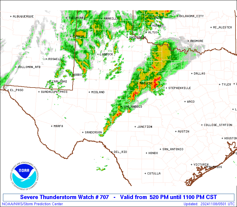
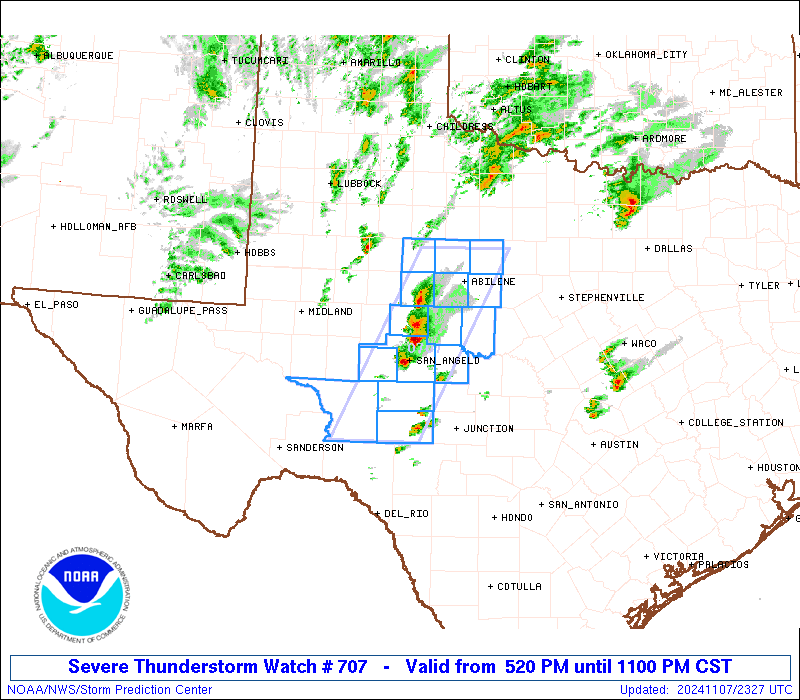
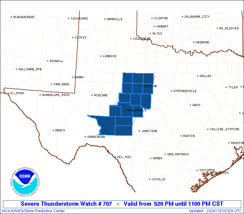
Severe Thunderstorm Watch Number 707
NWS Storm Prediction Center Norman OK
520 PM CST Thu Nov 7 2024
The NWS Storm Prediction Center has issued a
* Severe Thunderstorm Watch for portions of
West-Central Texas
* Effective this Thursday afternoon and evening from 520 PM until
1100 PM CST.
* Primary threats include...
Scattered large hail and isolated very large hail events to 2
inches in diameter possible
Scattered damaging wind gusts to 70 mph possible
A tornado or two possible
SUMMARY...Thunderstorms have formed early this evening along a
boundary, and will move generally east-northeastward over the next
several hours. Scattered large hail around 1-1.75 inches in diameter
should be the main threat with this activity, although some severe
wind gusts up to 60-70 mph may also occur. A tornado also appears
possible with any sustained supercell.
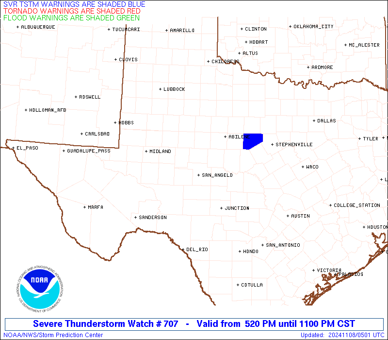
The severe thunderstorm watch area is approximately along and 40
statute miles east and west of a line from 30 miles north of Abilene
TX to 80 miles south southwest of San Angelo TX. For a complete
depiction of the watch see the associated watch outline update
(WOUS64 KWNS WOU7).
PRECAUTIONARY/PREPAREDNESS ACTIONS...
REMEMBER...A Severe Thunderstorm Watch means conditions are
favorable for severe thunderstorms in and close to the watch area.
Persons in these areas should be on the lookout for threatening
weather conditions and listen for later statements and possible
warnings. Severe thunderstorms can and occasionally do produce
tornadoes.
&&
AVIATION...A few severe thunderstorms with hail surface and aloft to
2 inches. Extreme turbulence and surface wind gusts to 60 knots. A
few cumulonimbi with maximum tops to 500. Mean storm motion vector
23030.
...Gleason

   SEL7

   URGENT - IMMEDIATE BROADCAST REQUESTED
   Severe Thunderstorm Watch Number 707
   NWS Storm Prediction Center Norman OK
   520 PM CST Thu Nov 7 2024

   The NWS Storm Prediction Center has issued a

   * Severe Thunderstorm Watch for portions of
     West-Central Texas

   * Effective this Thursday afternoon and evening from 520 PM until
     1100 PM CST.

   * Primary threats include...
     Scattered large hail and isolated very large hail events to 2
       inches in diameter possible
     Scattered damaging wind gusts to 70 mph possible
     A tornado or two possible

   SUMMARY...Thunderstorms have formed early this evening along a
   boundary, and will move generally east-northeastward over the next
   several hours. Scattered large hail around 1-1.75 inches in diameter
   should be the main threat with this activity, although some severe
   wind gusts up to 60-70 mph may also occur. A tornado also appears
   possible with any sustained supercell.

   The severe thunderstorm watch area is approximately along and 40
   statute miles east and west of a line from 30 miles north of Abilene
   TX to 80 miles south southwest of San Angelo TX. For a complete
   depiction of the watch see the associated watch outline update
   (WOUS64 KWNS WOU7).

   PRECAUTIONARY/PREPAREDNESS ACTIONS...

   REMEMBER...A Severe Thunderstorm Watch means conditions are
   favorable for severe thunderstorms in and close to the watch area.
   Persons in these areas should be on the lookout for threatening
   weather conditions and listen for later statements and possible
   warnings. Severe thunderstorms can and occasionally do produce
   tornadoes.

   &&

   AVIATION...A few severe thunderstorms with hail surface and aloft to
   2 inches. Extreme turbulence and surface wind gusts to 60 knots. A
   few cumulonimbi with maximum tops to 500. Mean storm motion vector
   23030.

   ...Gleason
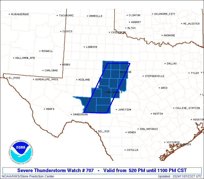
 Note:
The Aviation Watch (SAW) product is an approximation to the watch area.
The actual watch is depicted by the shaded areas.
Note:
The Aviation Watch (SAW) product is an approximation to the watch area.
The actual watch is depicted by the shaded areas.
   SAW7
   WW 707 SEVERE TSTM TX 072320Z - 080500Z
   AXIS..40 STATUTE MILES EAST AND WEST OF LINE..
   30N ABI/ABILENE TX/ - 80SSW SJT/SAN ANGELO TX/
   ..AVIATION COORDS.. 35NM E/W /24NNE ABI - 58NNW DLF/
   HAIL SURFACE AND ALOFT..2 INCHES. WIND GUSTS..60 KNOTS.
   MAX TOPS TO 500. MEAN STORM MOTION VECTOR 23030.

   LAT...LON 32849899 30300034 30300168 32840037

   THIS IS AN APPROXIMATION TO THE WATCH AREA.  FOR A
   COMPLETE DEPICTION OF THE WATCH SEE WOUS64 KWNS
   FOR WOU7.
Watch 707 Status Report Messages:
STATUS REPORT #5 ON WW 707

VALID 080425Z - 080500Z

SEVERE WEATHER THREAT CONTINUES RIGHT OF A LINE FROM 40 ENE 6R6
TO 35 WSW ABI TO 30 N ABI.

REMAINING VALID PORTION OF WW 707 MAY BE ALLOWED TO EXPIRE AT
08/05Z.

..KERR..11/08/24

ATTN...WFO...SJT...

&&

STATUS REPORT FOR WS 707

SEVERE WEATHER THREAT CONTINUES FOR THE FOLLOWING AREAS

TXC049-059-081-083-095-105-235-253-399-413-417-435-441-451-
080500-

TX
.    TEXAS COUNTIES INCLUDED ARE

BROWN		     CALLAHAN		 COKE
COLEMAN 	     CONCHO		 CROCKETT
IRION		     JONES		 RUNNELS
SCHLEICHER	     SHACKELFORD	 SUTTON
TAYLOR		     TOM GREEN
$$


THE WATCH STATUS MESSAGE IS FOR GUIDANCE PURPOSES ONLY.  PLEASE
REFER TO WATCH COUNTY NOTIFICATION STATEMENTS FOR OFFICIAL
INFORMATION ON COUNTIES...INDEPENDENT CITIES AND MARINE ZONES
CLEARED FROM SEVERE THUNDERSTORM AND TORNADO WATCHES.
$$

STATUS REPORT #4 ON WW 707

VALID 080330Z - 080440Z

SEVERE WEATHER THREAT CONTINUES RIGHT OF A LINE FROM 30 SE BGS TO
35 WSW ABI TO 50 NNW ABI.

..THORNTON..11/08/24

ATTN...WFO...SJT...

&&

STATUS REPORT FOR WS 707

SEVERE WEATHER THREAT CONTINUES FOR THE FOLLOWING AREAS

TXC049-059-081-083-095-105-235-253-399-413-417-435-441-451-
080440-

TX
.    TEXAS COUNTIES INCLUDED ARE

BROWN		     CALLAHAN		 COKE
COLEMAN 	     CONCHO		 CROCKETT
IRION		     JONES		 RUNNELS
SCHLEICHER	     SHACKELFORD	 SUTTON
TAYLOR		     TOM GREEN
$$


THE WATCH STATUS MESSAGE IS FOR GUIDANCE PURPOSES ONLY.  PLEASE
REFER TO WATCH COUNTY NOTIFICATION STATEMENTS FOR OFFICIAL
INFORMATION ON COUNTIES...INDEPENDENT CITIES AND MARINE ZONES
CLEARED FROM SEVERE THUNDERSTORM AND TORNADO WATCHES.
$$

STATUS REPORT #3 ON WW 707

VALID 080235Z - 080340Z

SEVERE WEATHER THREAT CONTINUES RIGHT OF A LINE FROM 30 SE BGS TO
35 WSW ABI TO 50 NNW ABI.

..THORNTON..11/08/24

ATTN...WFO...SJT...

&&

STATUS REPORT FOR WS 707

SEVERE WEATHER THREAT CONTINUES FOR THE FOLLOWING AREAS

TXC049-059-081-083-095-105-235-253-399-413-417-435-441-451-
080340-

TX
.    TEXAS COUNTIES INCLUDED ARE

BROWN		     CALLAHAN		 COKE
COLEMAN 	     CONCHO		 CROCKETT
IRION		     JONES		 RUNNELS
SCHLEICHER	     SHACKELFORD	 SUTTON
TAYLOR		     TOM GREEN
$$


THE WATCH STATUS MESSAGE IS FOR GUIDANCE PURPOSES ONLY.  PLEASE
REFER TO WATCH COUNTY NOTIFICATION STATEMENTS FOR OFFICIAL
INFORMATION ON COUNTIES...INDEPENDENT CITIES AND MARINE ZONES
CLEARED FROM SEVERE THUNDERSTORM AND TORNADO WATCHES.
$$

STATUS REPORT #2 ON WW 707

VALID 080140Z - 080240Z

SEVERE WEATHER THREAT CONTINUES RIGHT OF A LINE FROM 30 SE BGS TO
35 WSW ABI TO 50 NNW ABI.

..THORNTON..11/08/24

ATTN...WFO...SJT...

&&

STATUS REPORT FOR WS 707

SEVERE WEATHER THREAT CONTINUES FOR THE FOLLOWING AREAS

TXC059-081-083-095-105-235-253-399-413-417-435-441-451-080240-

TX
.    TEXAS COUNTIES INCLUDED ARE

CALLAHAN	     COKE		 COLEMAN
CONCHO		     CROCKETT		 IRION
JONES		     RUNNELS		 SCHLEICHER
SHACKELFORD	     SUTTON		 TAYLOR
TOM GREEN
$$


THE WATCH STATUS MESSAGE IS FOR GUIDANCE PURPOSES ONLY.  PLEASE
REFER TO WATCH COUNTY NOTIFICATION STATEMENTS FOR OFFICIAL
INFORMATION ON COUNTIES...INDEPENDENT CITIES AND MARINE ZONES
CLEARED FROM SEVERE THUNDERSTORM AND TORNADO WATCHES.
$$

STATUS REPORT #1 ON WW 707

VALID 080030Z - 080140Z

THE SEVERE WEATHER THREAT CONTINUES ACROSS THE ENTIRE WATCH AREA.

..THORNTON..11/08/24

ATTN...WFO...SJT...

&&

STATUS REPORT FOR WS 707

SEVERE WEATHER THREAT CONTINUES FOR THE FOLLOWING AREAS

TXC059-081-083-095-105-151-235-253-353-399-413-417-435-441-451-
080140-

TX
.    TEXAS COUNTIES INCLUDED ARE

CALLAHAN	     COKE		 COLEMAN
CONCHO		     CROCKETT		 FISHER
IRION		     JONES		 NOLAN
RUNNELS 	     SCHLEICHER 	 SHACKELFORD
SUTTON		     TAYLOR		 TOM GREEN
$$


THE WATCH STATUS MESSAGE IS FOR GUIDANCE PURPOSES ONLY.  PLEASE
REFER TO WATCH COUNTY NOTIFICATION STATEMENTS FOR OFFICIAL
INFORMATION ON COUNTIES...INDEPENDENT CITIES AND MARINE ZONES
CLEARED FROM SEVERE THUNDERSTORM AND TORNADO WATCHES.
$$
Note:
Click for Complete Product Text.
Tornadoes
Probability of 2 or more tornadoes
|
Low (20%)
|
Probability of 1 or more strong (EF2-EF5) tornadoes
|
Low (10%)
|
Wind
Probability of 10 or more severe wind events
|
Mod (40%)
|
Probability of 1 or more wind events > 65 knots
|
Low (10%)
|
Hail
Probability of 10 or more severe hail events
|
Mod (50%)
|
Probability of 1 or more hailstones > 2 inches
|
Mod (30%)
|
Combined Severe Hail/Wind
Probability of 6 or more combined severe hail/wind events
|
High (70%)
|
For each watch, probabilities for particular events inside the watch
(listed above in each table) are determined by the issuing forecaster.
The "Low" category contains probability values ranging from less than 2%
to 20% (EF2-EF5 tornadoes), less than 5% to 20% (all other probabilities),
"Moderate" from 30% to 60%, and "High" from 70% to greater than 95%.
High values are bolded and lighter in color to provide awareness of
an increased threat for a particular event.


 @NWSSPC