Note:
The expiration time in the watch graphic is amended if the watch is
replaced, cancelled or extended.
Note:
Note:
The expiration time in the watch graphic is amended if the watch is
replaced, cancelled or extended.
Note: Click for
Watch Status Reports.
SEL4
URGENT - IMMEDIATE BROADCAST REQUESTED
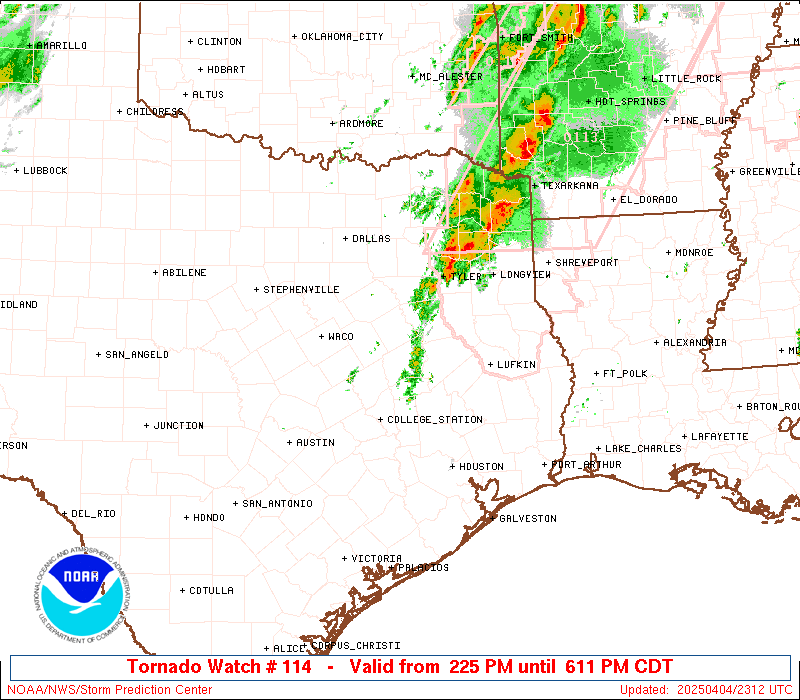
Tornado Watch Number 114
NWS Storm Prediction Center Norman OK
225 PM CDT Fri Apr 4 2025
The NWS Storm Prediction Center has issued a
* Tornado Watch for portions of
East central and southeast Texas
* Effective this Friday afternoon and evening from 225 PM until
900 PM CDT.
* Primary threats include...
A few tornadoes possible
Scattered large hail and isolated very large hail events to 2.5
inches in diameter likely
Scattered damaging wind gusts to 70 mph possible
SUMMARY...Thunderstorms will intensify along and east of a
slow-moving front across east and southeast Texas through the
afternoon/evening. The storm environment will favor supercells
capable of producing isolated very large hail (up to 2.5 inches in
diameter), damaging gusts of 60-70 mph, and a few tornadoes.
The tornado watch area is approximately along and 60 statute miles
east and west of a line from 20 miles north northeast of Longview TX
to 35 miles west southwest of College Station TX. For a complete
depiction of the watch see the associated watch outline update
(WOUS64 KWNS WOU4).
PRECAUTIONARY/PREPAREDNESS ACTIONS...
REMEMBER...A Tornado Watch means conditions are favorable for
tornadoes and severe thunderstorms in and close to the watch
area. Persons in these areas should be on the lookout for
threatening weather conditions and listen for later statements
and possible warnings.
&&
OTHER WATCH INFORMATION...CONTINUE...WW 113...
AVIATION...Tornadoes and a few severe thunderstorms with hail
surface and aloft to 2.5 inches. Extreme turbulence and surface wind
gusts to 60 knots. A few cumulonimbi with maximum tops to 600. Mean
storm motion vector 22030.
...Thompson
   SEL4

   URGENT - IMMEDIATE BROADCAST REQUESTED
   Tornado Watch Number 114
   NWS Storm Prediction Center Norman OK
   225 PM CDT Fri Apr 4 2025

   The NWS Storm Prediction Center has issued a

   * Tornado Watch for portions of
     East central and southeast Texas

   * Effective this Friday afternoon and evening from 225 PM until
     900 PM CDT.

   * Primary threats include...
     A few tornadoes possible
     Scattered large hail and isolated very large hail events to 2.5
       inches in diameter likely
     Scattered damaging wind gusts to 70 mph possible

   SUMMARY...Thunderstorms will intensify along and east of a
   slow-moving front across east and southeast Texas through the
   afternoon/evening.  The storm environment will favor supercells
   capable of producing isolated very large hail (up to 2.5 inches in
   diameter), damaging gusts of 60-70 mph, and a few tornadoes.

   The tornado watch area is approximately along and 60 statute miles
   east and west of a line from 20 miles north northeast of Longview TX
   to 35 miles west southwest of College Station TX. For a complete
   depiction of the watch see the associated watch outline update
   (WOUS64 KWNS WOU4).

   PRECAUTIONARY/PREPAREDNESS ACTIONS...

   REMEMBER...A Tornado Watch means conditions are favorable for
   tornadoes and severe thunderstorms in and close to the watch
   area. Persons in these areas should be on the lookout for
   threatening weather conditions and listen for later statements
   and possible warnings.

   &&

   OTHER WATCH INFORMATION...CONTINUE...WW 113...

   AVIATION...Tornadoes and a few severe thunderstorms with hail
   surface and aloft to 2.5 inches. Extreme turbulence and surface wind
   gusts to 60 knots. A few cumulonimbi with maximum tops to 600. Mean
   storm motion vector 22030.

   ...Thompson
 Note:
The Aviation Watch (SAW) product is an approximation to the watch area.
The actual watch is depicted by the shaded areas.
Note:
The Aviation Watch (SAW) product is an approximation to the watch area.
The actual watch is depicted by the shaded areas.
   SAW4
   WW 114 TORNADO TX 041925Z - 050200Z
   AXIS..60 STATUTE MILES EAST AND WEST OF LINE..
   20NNE GGG/LONGVIEW TX/ - 35WSW CLL/COLLEGE STATION TX/
   ..AVIATION COORDS.. 50NM E/W /16NNE GGG - 32E CWK/
   HAIL SURFACE AND ALOFT..2.5 INCHES. WIND GUSTS..60 KNOTS.
   MAX TOPS TO 600. MEAN STORM MOTION VECTOR 22030.

   LAT...LON 32649356 30389591 30389792 32649562

   THIS IS AN APPROXIMATION TO THE WATCH AREA.  FOR A
   COMPLETE DEPICTION OF THE WATCH SEE WOUS64 KWNS
   FOR WOU4.
Watch 114 Status Report Messages:
STATUS REPORT #3 ON WW 114

VALID 042300Z - 050040Z

SEVERE WEATHER THREAT CONTINUES RIGHT OF A LINE FROM 5 NE AUS TO
30 NNW CLL TO 40 ESE CRS TO 35 NNE TYR.

..LYONS..04/04/25

ATTN...WFO...FWD...HGX...

&&

STATUS REPORT FOR WT 114

SEVERE WEATHER THREAT CONTINUES FOR THE FOLLOWING AREAS

TXC001-041-051-185-225-289-313-455-471-050040-

TX
.    TEXAS COUNTIES INCLUDED ARE

ANDERSON	     BRAZOS		 BURLESON
GRIMES		     HOUSTON		 LEON
MADISON 	     TRINITY		 WALKER
$$


THE WATCH STATUS MESSAGE IS FOR GUIDANCE PURPOSES ONLY.  PLEASE
REFER TO WATCH COUNTY NOTIFICATION STATEMENTS FOR OFFICIAL
INFORMATION ON COUNTIES...INDEPENDENT CITIES AND MARINE ZONES
CLEARED FROM SEVERE THUNDERSTORM AND TORNADO WATCHES.
$$

STATUS REPORT #2 ON WW 114

VALID 042150Z - 042240Z

SEVERE WEATHER THREAT CONTINUES RIGHT OF A LINE FROM 15 WNW AUS
TO 45 ESE ACT TO 30 SW TYR TO 40 NNW TYR.

..LYONS..04/04/25

ATTN...WFO...FWD...HGX...

&&

STATUS REPORT FOR WT 114

SEVERE WEATHER THREAT CONTINUES FOR THE FOLLOWING AREAS

TXC001-041-051-161-185-213-223-225-289-313-331-379-395-455-467-
471-042240-

TX
.    TEXAS COUNTIES INCLUDED ARE

ANDERSON	     BRAZOS		 BURLESON
FREESTONE	     GRIMES		 HENDERSON
HOPKINS 	     HOUSTON		 LEON
MADISON 	     MILAM		 RAINS
ROBERTSON	     TRINITY		 VAN ZANDT
WALKER
$$


THE WATCH STATUS MESSAGE IS FOR GUIDANCE PURPOSES ONLY.  PLEASE
REFER TO WATCH COUNTY NOTIFICATION STATEMENTS FOR OFFICIAL
INFORMATION ON COUNTIES...INDEPENDENT CITIES AND MARINE ZONES
CLEARED FROM SEVERE THUNDERSTORM AND TORNADO WATCHES.
$$

STATUS REPORT #1 ON WW 114

VALID 042055Z - 042140Z

THE SEVERE WEATHER THREAT CONTINUES ACROSS THE ENTIRE WATCH AREA.

..LYONS..04/04/25

ATTN...WFO...FWD...HGX...

&&

STATUS REPORT FOR WT 114

SEVERE WEATHER THREAT CONTINUES FOR THE FOLLOWING AREAS

TXC001-041-051-145-161-185-213-225-289-293-313-331-349-395-455-
467-471-042140-

TX
.    TEXAS COUNTIES INCLUDED ARE

ANDERSON	     BRAZOS		 BURLESON
FALLS		     FREESTONE		 GRIMES
HENDERSON	     HOUSTON		 LEON
LIMESTONE	     MADISON		 MILAM
NAVARRO 	     ROBERTSON		 TRINITY
VAN ZANDT	     WALKER
$$


THE WATCH STATUS MESSAGE IS FOR GUIDANCE PURPOSES ONLY.  PLEASE
REFER TO WATCH COUNTY NOTIFICATION STATEMENTS FOR OFFICIAL
INFORMATION ON COUNTIES...INDEPENDENT CITIES AND MARINE ZONES
CLEARED FROM SEVERE THUNDERSTORM AND TORNADO WATCHES.
$$
Note:
Click for Complete Product Text.
Tornadoes
Probability of 2 or more tornadoes
|
Mod (50%)
|
Probability of 1 or more strong (EF2-EF5) tornadoes
|
Low (20%)
|
Wind
Probability of 10 or more severe wind events
|
Mod (40%)
|
Probability of 1 or more wind events > 65 knots
|
Low (20%)
|
Hail
Probability of 10 or more severe hail events
|
Mod (60%)
|
Probability of 1 or more hailstones > 2 inches
|
Mod (60%)
|
Combined Severe Hail/Wind
Probability of 6 or more combined severe hail/wind events
|
High (90%)
|
For each watch, probabilities for particular events inside the watch
(listed above in each table) are determined by the issuing forecaster.
The "Low" category contains probability values ranging from less than 2%
to 20% (EF2-EF5 tornadoes), less than 5% to 20% (all other probabilities),
"Moderate" from 30% to 60%, and "High" from 70% to greater than 95%.
High values are bolded and lighter in color to provide awareness of
an increased threat for a particular event.


 @NWSSPC