 Note:
The expiration time in the watch graphic is amended if the watch is
replaced, cancelled or extended.
Note:
Note:
The expiration time in the watch graphic is amended if the watch is
replaced, cancelled or extended.
Note: Click for
Watch Status Reports.
SEL6
URGENT - IMMEDIATE BROADCAST REQUESTED
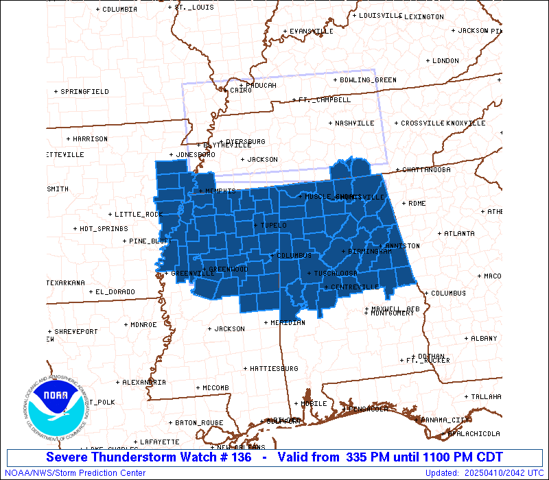
Severe Thunderstorm Watch Number 136
NWS Storm Prediction Center Norman OK
335 PM CDT Thu Apr 10 2025
The NWS Storm Prediction Center has issued a
* Severe Thunderstorm Watch for portions of
Northern and Central Alabama
Far Eastern Arkansas
Northern and Central Mississippi
Far Southern Middle Tennessee
* Effective this Thursday afternoon and evening from 335 PM until
1100 PM CDT.
* Primary threats include...
Scattered damaging winds likely with isolated significant gusts
to 75 mph possible
Scattered large hail likely with isolated very large hail events
to 2 inches in diameter possible
SUMMARY...Robust thunderstorms will continue to develop this
afternoon and spread southeastward through the evening. Supercells
will pose a threat for large hail generally ranging from 1-2 inches
in diameter. Scattered severe/damaging winds, with peak gusts up to
65-75 mph, should also occur as clusters form later this afternoon
and evening.
The severe thunderstorm watch area is approximately along and 70
statute miles north and south of a line from 55 miles north
northwest of Greenwood MS to 25 miles northeast of Anniston AL. For
a complete depiction of the watch see the associated watch outline
update (WOUS64 KWNS WOU6).
PRECAUTIONARY/PREPAREDNESS ACTIONS...
REMEMBER...A Severe Thunderstorm Watch means conditions are
favorable for severe thunderstorms in and close to the watch area.
Persons in these areas should be on the lookout for threatening
weather conditions and listen for later statements and possible
warnings. Severe thunderstorms can and occasionally do produce
tornadoes.
&&
OTHER WATCH INFORMATION...CONTINUE...WW 135...
AVIATION...A few severe thunderstorms with hail surface and aloft to
2 inches. Extreme turbulence and surface wind gusts to 65 knots. A
few cumulonimbi with maximum tops to 500. Mean storm motion vector
31035.
...Gleason

   SEL6

   URGENT - IMMEDIATE BROADCAST REQUESTED
   Severe Thunderstorm Watch Number 136
   NWS Storm Prediction Center Norman OK
   335 PM CDT Thu Apr 10 2025

   The NWS Storm Prediction Center has issued a

   * Severe Thunderstorm Watch for portions of
     Northern and Central Alabama
     Far Eastern Arkansas
     Northern and Central Mississippi
     Far Southern Middle Tennessee

   * Effective this Thursday afternoon and evening from 335 PM until
     1100 PM CDT.

   * Primary threats include...
     Scattered damaging winds likely with isolated significant gusts
       to 75 mph possible
     Scattered large hail likely with isolated very large hail events
       to 2 inches in diameter possible

   SUMMARY...Robust thunderstorms will continue to develop this
   afternoon and spread southeastward through the evening. Supercells
   will pose a threat for large hail generally ranging from 1-2 inches
   in diameter. Scattered severe/damaging winds, with peak gusts up to
   65-75 mph, should also occur as clusters form later this afternoon
   and evening.

   The severe thunderstorm watch area is approximately along and 70
   statute miles north and south of a line from 55 miles north
   northwest of Greenwood MS to 25 miles northeast of Anniston AL. For
   a complete depiction of the watch see the associated watch outline
   update (WOUS64 KWNS WOU6).

   PRECAUTIONARY/PREPAREDNESS ACTIONS...

   REMEMBER...A Severe Thunderstorm Watch means conditions are
   favorable for severe thunderstorms in and close to the watch area.
   Persons in these areas should be on the lookout for threatening
   weather conditions and listen for later statements and possible
   warnings. Severe thunderstorms can and occasionally do produce
   tornadoes.

   &&

   OTHER WATCH INFORMATION...CONTINUE...WW 135...

   AVIATION...A few severe thunderstorms with hail surface and aloft to
   2 inches. Extreme turbulence and surface wind gusts to 65 knots. A
   few cumulonimbi with maximum tops to 500. Mean storm motion vector
   31035.

   ...Gleason
 Note:
The Aviation Watch (SAW) product is an approximation to the watch area.
The actual watch is depicted by the shaded areas.
Note:
The Aviation Watch (SAW) product is an approximation to the watch area.
The actual watch is depicted by the shaded areas.
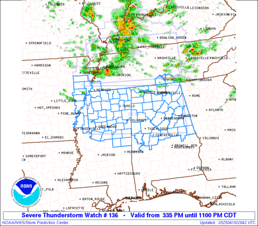
   SAW6
   WW 136 SEVERE TSTM AL AR MS TN 102035Z - 110400Z
   AXIS..70 STATUTE MILES NORTH AND SOUTH OF LINE..
   55NNW GWO/GREENWOOD MS/ - 25NE ANB/ANNISTON AL/
   ..AVIATION COORDS.. 60NM N/S /47N SQS - 50NNW LGC/
   HAIL SURFACE AND ALOFT..2 INCHES. WIND GUSTS..65 KNOTS.
   MAX TOPS TO 500. MEAN STORM MOTION VECTOR 31035.

   LAT...LON 35259045 34848554 32828554 33229045

   THIS IS AN APPROXIMATION TO THE WATCH AREA.  FOR A
   COMPLETE DEPICTION OF THE WATCH SEE WOUS64 KWNS
   FOR WOU6.
Watch 136 Status Report Messages:
STATUS REPORT #3 ON WW 136
VALID 102330Z - 110040Z
THE SEVERE WEATHER THREAT CONTINUES ACROSS THE ENTIRE WATCH AREA.
..MARSH..04/10/25
ATTN...WFO...BMX...HUN...MEG...JAN...
&&
STATUS REPORT FOR WS 136
SEVERE WEATHER THREAT CONTINUES FOR THE FOLLOWING AREAS
ALC007-009-015-017-019-021-027-029-033-037-043-049-055-057-059-
063-065-071-073-075-077-079-083-089-093-095-103-105-107-111-115-
117-119-121-123-125-127-133-110040-
AL
. ALABAMA COUNTIES INCLUDED ARE
BIBB BLOUNT CALHOUN
CHAMBERS CHEROKEE CHILTON
CLAY CLEBURNE COLBERT
COOSA CULLMAN DEKALB
ETOWAH FAYETTE FRANKLIN
GREENE HALE JACKSON
JEFFERSON LAMAR LAUDERDALE
LAWRENCE LIMESTONE MADISON
MARION MARSHALL MORGAN
PERRY PICKENS RANDOLPH
ST. CLAIR SHELBY SUMTER
TALLADEGA TALLAPOOSA TUSCALOOSA
WALKER WINSTON
$$
ARC107-110040-
AR
. ARKANSAS COUNTIES INCLUDED ARE
PHILLIPS
$$
MSC003-007-009-011-013-015-017-019-025-027-033-043-051-057-069-
071-081-083-087-093-095-097-099-103-105-107-115-117-119-133-135-
137-139-141-143-145-155-159-161-110040-
MS
. MISSISSIPPI COUNTIES INCLUDED ARE
ALCORN ATTALA BENTON
BOLIVAR CALHOUN CARROLL
CHICKASAW CHOCTAW CLAY
COAHOMA DESOTO GRENADA
HOLMES ITAWAMBA KEMPER
LAFAYETTE LEE LEFLORE
LOWNDES MARSHALL MONROE
MONTGOMERY NESHOBA NOXUBEE
OKTIBBEHA PANOLA PONTOTOC
PRENTISS QUITMAN SUNFLOWER
TALLAHATCHIE TATE TIPPAH
TISHOMINGO TUNICA UNION
WEBSTER WINSTON YALOBUSHA
$$
TNC051-103-127-110040-
TN
. TENNESSEE COUNTIES INCLUDED ARE
FRANKLIN LINCOLN MOORE
$$
THE WATCH STATUS MESSAGE IS FOR GUIDANCE PURPOSES ONLY. PLEASE
REFER TO WATCH COUNTY NOTIFICATION STATEMENTS FOR OFFICIAL
INFORMATION ON COUNTIES...INDEPENDENT CITIES AND MARINE ZONES
CLEARED FROM SEVERE THUNDERSTORM AND TORNADO WATCHES.
$$
STATUS REPORT #2 ON WW 136
VALID 102225Z - 102340Z
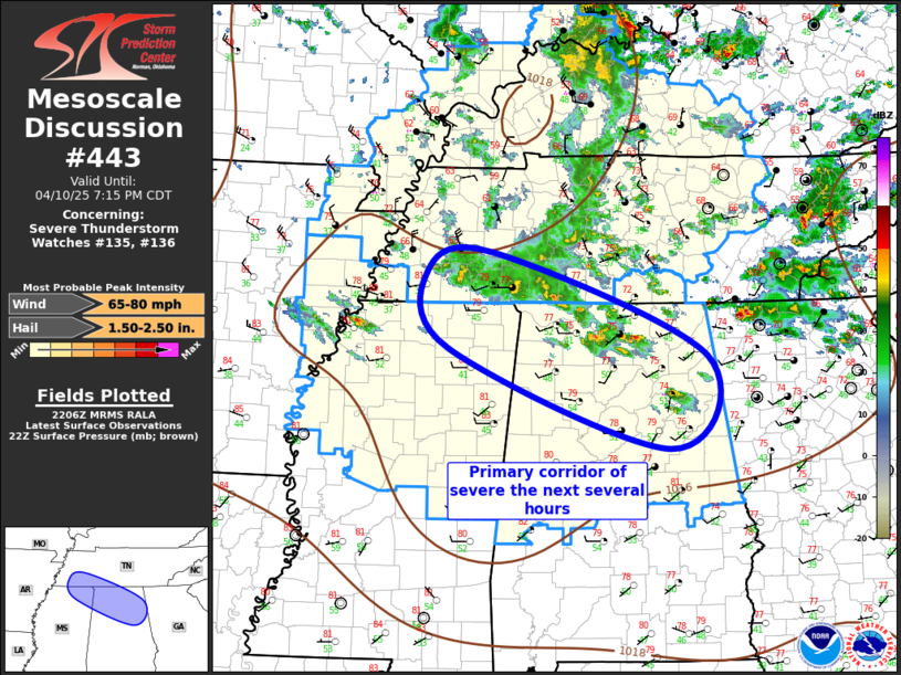
SEVERE WEATHER THREAT CONTINUES RIGHT OF A LINE FROM 30 SW MEM TO
10 E MEM TO 25 ENE MEM.
FOR ADDITIONAL INFORMATION SEE MESOSCALE DISCUSSION 443
..MARSH..04/10/25
ATTN...WFO...BMX...HUN...MEG...JAN...
&&
STATUS REPORT FOR WS 136
SEVERE WEATHER THREAT CONTINUES FOR THE FOLLOWING AREAS
ALC007-009-015-017-019-021-027-029-033-037-043-049-055-057-059-
063-065-071-073-075-077-079-083-089-093-095-103-105-107-111-115-
117-119-121-123-125-127-133-102340-
AL
. ALABAMA COUNTIES INCLUDED ARE
BIBB BLOUNT CALHOUN
CHAMBERS CHEROKEE CHILTON
CLAY CLEBURNE COLBERT
COOSA CULLMAN DEKALB
ETOWAH FAYETTE FRANKLIN
GREENE HALE JACKSON
JEFFERSON LAMAR LAUDERDALE
LAWRENCE LIMESTONE MADISON
MARION MARSHALL MORGAN
PERRY PICKENS RANDOLPH
ST. CLAIR SHELBY SUMTER
TALLADEGA TALLAPOOSA TUSCALOOSA
WALKER WINSTON
$$
ARC035-037-077-107-111-123-102340-
AR
. ARKANSAS COUNTIES INCLUDED ARE
CRITTENDEN CROSS LEE
PHILLIPS POINSETT ST. FRANCIS
$$
MSC003-007-009-011-013-015-017-019-025-027-033-043-051-057-069-
071-081-083-087-093-095-097-099-103-105-107-115-117-119-133-135-
137-139-141-143-145-155-159-161-102340-
MS
. MISSISSIPPI COUNTIES INCLUDED ARE
ALCORN ATTALA BENTON
BOLIVAR CALHOUN CARROLL
CHICKASAW CHOCTAW CLAY
COAHOMA DESOTO GRENADA
HOLMES ITAWAMBA KEMPER
LAFAYETTE LEE LEFLORE
LOWNDES MARSHALL MONROE
MONTGOMERY NESHOBA NOXUBEE
OKTIBBEHA PANOLA PONTOTOC
PRENTISS QUITMAN SUNFLOWER
TALLAHATCHIE TATE TIPPAH
TISHOMINGO TUNICA UNION
WEBSTER WINSTON YALOBUSHA
$$
TNC051-103-127-157-102340-
TN
. TENNESSEE COUNTIES INCLUDED ARE
FRANKLIN LINCOLN MOORE
SHELBY
$$
THE WATCH STATUS MESSAGE IS FOR GUIDANCE PURPOSES ONLY. PLEASE
REFER TO WATCH COUNTY NOTIFICATION STATEMENTS FOR OFFICIAL
INFORMATION ON COUNTIES...INDEPENDENT CITIES AND MARINE ZONES
CLEARED FROM SEVERE THUNDERSTORM AND TORNADO WATCHES.
$$
STATUS REPORT #1 ON WW 136
VALID 102135Z - 102240Z
THE SEVERE WEATHER THREAT CONTINUES ACROSS THE ENTIRE WATCH AREA.
..MARSH..04/10/25
ATTN...WFO...BMX...HUN...MEG...JAN...
&&
STATUS REPORT FOR WS 136
SEVERE WEATHER THREAT CONTINUES FOR THE FOLLOWING AREAS
ALC007-009-015-017-019-021-027-029-033-037-043-049-055-057-059-
063-065-071-073-075-077-079-083-089-093-095-103-105-107-111-115-
117-119-121-123-125-127-133-102240-
AL
. ALABAMA COUNTIES INCLUDED ARE
BIBB BLOUNT CALHOUN
CHAMBERS CHEROKEE CHILTON
CLAY CLEBURNE COLBERT
COOSA CULLMAN DEKALB
ETOWAH FAYETTE FRANKLIN
GREENE HALE JACKSON
JEFFERSON LAMAR LAUDERDALE
LAWRENCE LIMESTONE MADISON
MARION MARSHALL MORGAN
PERRY PICKENS RANDOLPH
ST. CLAIR SHELBY SUMTER
TALLADEGA TALLAPOOSA TUSCALOOSA
WALKER WINSTON
$$
ARC035-037-077-107-111-123-102240-
AR
. ARKANSAS COUNTIES INCLUDED ARE
CRITTENDEN CROSS LEE
PHILLIPS POINSETT ST. FRANCIS
$$
MSC003-007-009-011-013-015-017-019-025-027-033-043-051-057-069-
071-081-083-087-093-095-097-099-103-105-107-115-117-119-133-135-
137-139-141-143-145-155-159-161-102240-
MS
. MISSISSIPPI COUNTIES INCLUDED ARE
ALCORN ATTALA BENTON
BOLIVAR CALHOUN CARROLL
CHICKASAW CHOCTAW CLAY
COAHOMA DESOTO GRENADA
HOLMES ITAWAMBA KEMPER
LAFAYETTE LEE LEFLORE
LOWNDES MARSHALL MONROE
MONTGOMERY NESHOBA NOXUBEE
OKTIBBEHA PANOLA PONTOTOC
PRENTISS QUITMAN SUNFLOWER
TALLAHATCHIE TATE TIPPAH
TISHOMINGO TUNICA UNION
WEBSTER WINSTON YALOBUSHA
$$
TNC051-103-127-157-102240-
TN
. TENNESSEE COUNTIES INCLUDED ARE
FRANKLIN LINCOLN MOORE
SHELBY
$$
THE WATCH STATUS MESSAGE IS FOR GUIDANCE PURPOSES ONLY. PLEASE
REFER TO WATCH COUNTY NOTIFICATION STATEMENTS FOR OFFICIAL
INFORMATION ON COUNTIES...INDEPENDENT CITIES AND MARINE ZONES
CLEARED FROM SEVERE THUNDERSTORM AND TORNADO WATCHES.
$$
Note:
Click for Complete Product Text.
Tornadoes
Probability of 2 or more tornadoes
|
Low (<5%)
|
Probability of 1 or more strong (EF2-EF5) tornadoes
|
Low (<2%)
|
Wind
Probability of 10 or more severe wind events
|
Mod (60%)
|
Probability of 1 or more wind events > 65 knots
|
Mod (30%)
|
Hail
Probability of 10 or more severe hail events
|
Mod (60%)
|
Probability of 1 or more hailstones > 2 inches
|
Mod (30%)
|
Combined Severe Hail/Wind
Probability of 6 or more combined severe hail/wind events
|
High (90%)
|
For each watch, probabilities for particular events inside the watch
(listed above in each table) are determined by the issuing forecaster.
The "Low" category contains probability values ranging from less than 2%
to 20% (EF2-EF5 tornadoes), less than 5% to 20% (all other probabilities),
"Moderate" from 30% to 60%, and "High" from 70% to greater than 95%.
High values are bolded and lighter in color to provide awareness of
an increased threat for a particular event.


 @NWSSPC