 Note:
The expiration time in the watch graphic is amended if the watch is
replaced, cancelled or extended.
Note:
Note:
The expiration time in the watch graphic is amended if the watch is
replaced, cancelled or extended.
Note: Click for
Watch Status Reports.
SEL7
URGENT - IMMEDIATE BROADCAST REQUESTED
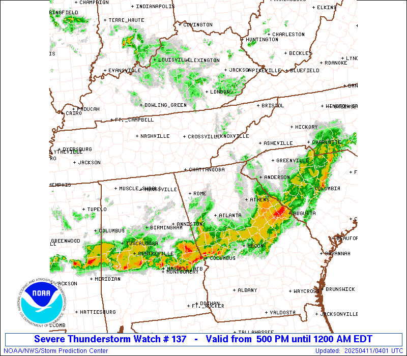
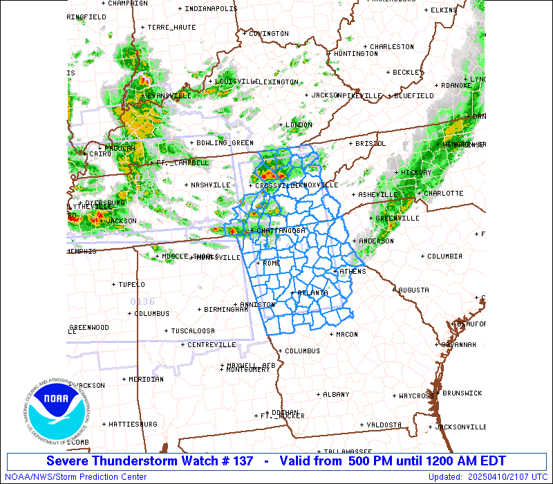
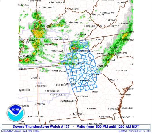
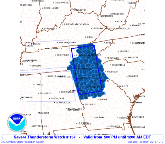
Severe Thunderstorm Watch Number 137
NWS Storm Prediction Center Norman OK
500 PM EDT Thu Apr 10 2025
The NWS Storm Prediction Center has issued a
* Severe Thunderstorm Watch for portions of
Northern and Central Georgia
Far Southwest North Carolina
Extreme Western South Carolina
Eastern Tennessee
* Effective this Thursday afternoon from 500 PM until Midnight
EDT.
* Primary threats include...
Scattered large hail and isolated very large hail events to 2
inches in diameter possible
Scattered damaging wind gusts to 70 mph possible
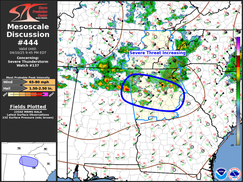
SUMMARY...Scattered supercells should continue to pose some threat
for severe hail up to 1-1.75 inches in diameter through the rest of
the afternoon and into the evening. Damaging winds may also occur
with any clusters that can form, before convection eventually
weakens with eastward extent.
The severe thunderstorm watch area is approximately along and 55
statute miles east and west of a line from 45 miles north northwest
of Knoxville TN to 30 miles south southeast of Atlanta GA. For a
complete depiction of the watch see the associated watch outline
update (WOUS64 KWNS WOU7).
PRECAUTIONARY/PREPAREDNESS ACTIONS...
REMEMBER...A Severe Thunderstorm Watch means conditions are
favorable for severe thunderstorms in and close to the watch area.
Persons in these areas should be on the lookout for threatening
weather conditions and listen for later statements and possible
warnings. Severe thunderstorms can and occasionally do produce
tornadoes.
&&
OTHER WATCH INFORMATION...CONTINUE...WW 135...WW 136...
AVIATION...A few severe thunderstorms with hail surface and aloft to
2 inches. Extreme turbulence and surface wind gusts to 60 knots. A
few cumulonimbi with maximum tops to 500. Mean storm motion vector
31035.
...Gleason

   SEL7

   URGENT - IMMEDIATE BROADCAST REQUESTED
   Severe Thunderstorm Watch Number 137
   NWS Storm Prediction Center Norman OK
   500 PM EDT Thu Apr 10 2025

   The NWS Storm Prediction Center has issued a

   * Severe Thunderstorm Watch for portions of
     Northern and Central Georgia
     Far Southwest North Carolina
     Extreme Western South Carolina
     Eastern Tennessee

   * Effective this Thursday afternoon from 500 PM until Midnight
     EDT.

   * Primary threats include...
     Scattered large hail and isolated very large hail events to 2
       inches in diameter possible
     Scattered damaging wind gusts to 70 mph possible

   SUMMARY...Scattered supercells should continue to pose some threat
   for severe hail up to 1-1.75 inches in diameter through the rest of
   the afternoon and into the evening. Damaging winds may also occur
   with any clusters that can form, before convection eventually
   weakens with eastward extent.

   The severe thunderstorm watch area is approximately along and 55
   statute miles east and west of a line from 45 miles north northwest
   of Knoxville TN to 30 miles south southeast of Atlanta GA. For a
   complete depiction of the watch see the associated watch outline
   update (WOUS64 KWNS WOU7).

   PRECAUTIONARY/PREPAREDNESS ACTIONS...

   REMEMBER...A Severe Thunderstorm Watch means conditions are
   favorable for severe thunderstorms in and close to the watch area.
   Persons in these areas should be on the lookout for threatening
   weather conditions and listen for later statements and possible
   warnings. Severe thunderstorms can and occasionally do produce
   tornadoes.

   &&

   OTHER WATCH INFORMATION...CONTINUE...WW 135...WW 136...

   AVIATION...A few severe thunderstorms with hail surface and aloft to
   2 inches. Extreme turbulence and surface wind gusts to 60 knots. A
   few cumulonimbi with maximum tops to 500. Mean storm motion vector
   31035.

   ...Gleason
 Note:
The Aviation Watch (SAW) product is an approximation to the watch area.
The actual watch is depicted by the shaded areas.
Note:
The Aviation Watch (SAW) product is an approximation to the watch area.
The actual watch is depicted by the shaded areas.
   SAW7
   WW 137 SEVERE TSTM GA NC SC TN 102100Z - 110400Z
   AXIS..55 STATUTE MILES EAST AND WEST OF LINE..
   45NNW TYS/KNOXVILLE TN/ - 30SSE ATL/ATLANTA GA/
   ..AVIATION COORDS.. 50NM E/W /37NNW VXV - 26SSE ATL/
   HAIL SURFACE AND ALOFT..2 INCHES. WIND GUSTS..60 KNOTS.
   MAX TOPS TO 500. MEAN STORM MOTION VECTOR 31035.

   LAT...LON 36418332 33238328 33238518 36418530

   THIS IS AN APPROXIMATION TO THE WATCH AREA.  FOR A
   COMPLETE DEPICTION OF THE WATCH SEE WOUS64 KWNS
   FOR WOU7.
Watch 137 Status Report Messages:
STATUS REPORT #3 ON WW 137

VALID 102330Z - 110040Z

THE SEVERE WEATHER THREAT CONTINUES ACROSS THE ENTIRE WATCH AREA.

..MARSH..04/10/25

ATTN...WFO...FFC...GSP...MRX...

&&

STATUS REPORT FOR WS 137

SEVERE WEATHER THREAT CONTINUES FOR THE FOLLOWING AREAS

GAC009-011-013-015-035-045-047-055-057-059-063-067-077-083-085-
089-097-105-111-113-115-117-119-121-123-129-133-135-137-139-143-
147-149-151-157-159-169-171-187-195-199-207-211-213-217-219-221-
223-227-231-233-237-241-247-255-257-281-285-291-295-297-311-313-
110040-

GA
.    GEORGIA COUNTIES INCLUDED ARE

BALDWIN 	     BANKS		 BARROW
BARTOW		     BUTTS		 CARROLL
CATOOSA 	     CHATTOOGA		 CHEROKEE
CLARKE		     CLAYTON		 COBB
COWETA		     DADE		 DAWSON
DEKALB		     DOUGLAS		 ELBERT
FANNIN		     FAYETTE		 FLOYD
FORSYTH 	     FRANKLIN		 FULTON
GILMER		     GORDON		 GREENE
GWINNETT	     HABERSHAM		 HALL
HARALSON	     HART		 HEARD
HENRY		     JACKSON		 JASPER
JONES		     LAMAR		 LUMPKIN
MADISON 	     MERIWETHER 	 MONROE
MORGAN		     MURRAY		 NEWTON
OCONEE		     OGLETHORPE 	 PAULDING
PICKENS 	     PIKE		 POLK
PUTNAM		     RABUN		 ROCKDALE
SPALDING	     STEPHENS		 TOWNS
TROUP		     UNION		 WALKER
WALTON		     WHITE		 WHITFIELD
$$


NCC039-043-075-099-113-173-110040-

NC
.    NORTH CAROLINA COUNTIES INCLUDED ARE

CHEROKEE	     CLAY		 GRAHAM
JACKSON 	     MACON		 SWAIN
$$


SCC073-110040-

SC
.    SOUTH CAROLINA COUNTIES INCLUDED ARE

OCONEE
$$


TNC001-007-009-011-013-025-057-065-089-093-105-107-115-121-123-
129-139-143-145-151-153-155-173-110040-

TN
.    TENNESSEE COUNTIES INCLUDED ARE

ANDERSON	     BLEDSOE		 BLOUNT
BRADLEY 	     CAMPBELL		 CLAIBORNE
GRAINGER	     HAMILTON		 JEFFERSON
KNOX		     LOUDON		 MCMINN
MARION		     MEIGS		 MONROE
MORGAN		     POLK		 RHEA
ROANE		     SCOTT		 SEQUATCHIE
SEVIER		     UNION
$$


THE WATCH STATUS MESSAGE IS FOR GUIDANCE PURPOSES ONLY.  PLEASE
REFER TO WATCH COUNTY NOTIFICATION STATEMENTS FOR OFFICIAL
INFORMATION ON COUNTIES...INDEPENDENT CITIES AND MARINE ZONES
CLEARED FROM SEVERE THUNDERSTORM AND TORNADO WATCHES.
$$

STATUS REPORT #2 ON WW 137

VALID 102225Z - 102340Z

THE SEVERE WEATHER THREAT CONTINUES ACROSS THE ENTIRE WATCH AREA.

FOR ADDITIONAL INFORMATION SEE MESOSCALE DISCUSSION 443

..MARSH..04/10/25

ATTN...WFO...FFC...GSP...MRX...

&&

STATUS REPORT FOR WS 137

SEVERE WEATHER THREAT CONTINUES FOR THE FOLLOWING AREAS

GAC009-011-013-015-035-045-047-055-057-059-063-067-077-083-085-
089-097-105-111-113-115-117-119-121-123-129-133-135-137-139-143-
147-149-151-157-159-169-171-187-195-199-207-211-213-217-219-221-
223-227-231-233-237-241-247-255-257-281-285-291-295-297-311-313-
102340-

GA
.    GEORGIA COUNTIES INCLUDED ARE

BALDWIN 	     BANKS		 BARROW
BARTOW		     BUTTS		 CARROLL
CATOOSA 	     CHATTOOGA		 CHEROKEE
CLARKE		     CLAYTON		 COBB
COWETA		     DADE		 DAWSON
DEKALB		     DOUGLAS		 ELBERT
FANNIN		     FAYETTE		 FLOYD
FORSYTH 	     FRANKLIN		 FULTON
GILMER		     GORDON		 GREENE
GWINNETT	     HABERSHAM		 HALL
HARALSON	     HART		 HEARD
HENRY		     JACKSON		 JASPER
JONES		     LAMAR		 LUMPKIN
MADISON 	     MERIWETHER 	 MONROE
MORGAN		     MURRAY		 NEWTON
OCONEE		     OGLETHORPE 	 PAULDING
PICKENS 	     PIKE		 POLK
PUTNAM		     RABUN		 ROCKDALE
SPALDING	     STEPHENS		 TOWNS
TROUP		     UNION		 WALKER
WALTON		     WHITE		 WHITFIELD
$$


NCC039-043-075-099-113-173-102340-

NC
.    NORTH CAROLINA COUNTIES INCLUDED ARE

CHEROKEE	     CLAY		 GRAHAM
JACKSON 	     MACON		 SWAIN
$$


SCC073-102340-

SC
.    SOUTH CAROLINA COUNTIES INCLUDED ARE

OCONEE
$$


TNC001-007-009-011-013-025-057-065-089-093-105-107-115-121-123-
129-139-143-145-151-153-155-173-102340-

TN
.    TENNESSEE COUNTIES INCLUDED ARE

ANDERSON	     BLEDSOE		 BLOUNT
BRADLEY 	     CAMPBELL		 CLAIBORNE
GRAINGER	     HAMILTON		 JEFFERSON
KNOX		     LOUDON		 MCMINN
MARION		     MEIGS		 MONROE
MORGAN		     POLK		 RHEA
ROANE		     SCOTT		 SEQUATCHIE
SEVIER		     UNION
$$


THE WATCH STATUS MESSAGE IS FOR GUIDANCE PURPOSES ONLY.  PLEASE
REFER TO WATCH COUNTY NOTIFICATION STATEMENTS FOR OFFICIAL
INFORMATION ON COUNTIES...INDEPENDENT CITIES AND MARINE ZONES
CLEARED FROM SEVERE THUNDERSTORM AND TORNADO WATCHES.
$$

STATUS REPORT #1 ON WW 137

VALID 102135Z - 102240Z

THE SEVERE WEATHER THREAT CONTINUES ACROSS THE ENTIRE WATCH AREA.

..MARSH..04/10/25

ATTN...WFO...FFC...GSP...MRX...

&&

STATUS REPORT FOR WS 137

SEVERE WEATHER THREAT CONTINUES FOR THE FOLLOWING AREAS

GAC009-011-013-015-035-045-047-055-057-059-063-067-077-083-085-
089-097-105-111-113-115-117-119-121-123-129-133-135-137-139-143-
147-149-151-157-159-169-171-187-195-199-207-211-213-217-219-221-
223-227-231-233-237-241-247-255-257-281-285-291-295-297-311-313-
102240-

GA
.    GEORGIA COUNTIES INCLUDED ARE

BALDWIN 	     BANKS		 BARROW
BARTOW		     BUTTS		 CARROLL
CATOOSA 	     CHATTOOGA		 CHEROKEE
CLARKE		     CLAYTON		 COBB
COWETA		     DADE		 DAWSON
DEKALB		     DOUGLAS		 ELBERT
FANNIN		     FAYETTE		 FLOYD
FORSYTH 	     FRANKLIN		 FULTON
GILMER		     GORDON		 GREENE
GWINNETT	     HABERSHAM		 HALL
HARALSON	     HART		 HEARD
HENRY		     JACKSON		 JASPER
JONES		     LAMAR		 LUMPKIN
MADISON 	     MERIWETHER 	 MONROE
MORGAN		     MURRAY		 NEWTON
OCONEE		     OGLETHORPE 	 PAULDING
PICKENS 	     PIKE		 POLK
PUTNAM		     RABUN		 ROCKDALE
SPALDING	     STEPHENS		 TOWNS
TROUP		     UNION		 WALKER
WALTON		     WHITE		 WHITFIELD
$$


NCC039-043-075-099-113-173-102240-

NC
.    NORTH CAROLINA COUNTIES INCLUDED ARE

CHEROKEE	     CLAY		 GRAHAM
JACKSON 	     MACON		 SWAIN
$$


SCC073-102240-

SC
.    SOUTH CAROLINA COUNTIES INCLUDED ARE

OCONEE
$$


TNC001-007-009-011-013-025-057-065-089-093-105-107-115-121-123-
129-139-143-145-151-153-155-173-102240-

TN
.    TENNESSEE COUNTIES INCLUDED ARE

ANDERSON	     BLEDSOE		 BLOUNT
BRADLEY 	     CAMPBELL		 CLAIBORNE
GRAINGER	     HAMILTON		 JEFFERSON
KNOX		     LOUDON		 MCMINN
MARION		     MEIGS		 MONROE
MORGAN		     POLK		 RHEA
ROANE		     SCOTT		 SEQUATCHIE
SEVIER		     UNION
$$


THE WATCH STATUS MESSAGE IS FOR GUIDANCE PURPOSES ONLY.  PLEASE
REFER TO WATCH COUNTY NOTIFICATION STATEMENTS FOR OFFICIAL
INFORMATION ON COUNTIES...INDEPENDENT CITIES AND MARINE ZONES
CLEARED FROM SEVERE THUNDERSTORM AND TORNADO WATCHES.
$$
Note:
Click for Complete Product Text.
Tornadoes
Probability of 2 or more tornadoes
|
Low (<5%)
|
Probability of 1 or more strong (EF2-EF5) tornadoes
|
Low (<2%)
|
Wind
Probability of 10 or more severe wind events
|
Mod (50%)
|
Probability of 1 or more wind events > 65 knots
|
Low (20%)
|
Hail
Probability of 10 or more severe hail events
|
Mod (40%)
|
Probability of 1 or more hailstones > 2 inches
|
Mod (30%)
|
Combined Severe Hail/Wind
Probability of 6 or more combined severe hail/wind events
|
High (70%)
|
For each watch, probabilities for particular events inside the watch
(listed above in each table) are determined by the issuing forecaster.
The "Low" category contains probability values ranging from less than 2%
to 20% (EF2-EF5 tornadoes), less than 5% to 20% (all other probabilities),
"Moderate" from 30% to 60%, and "High" from 70% to greater than 95%.
High values are bolded and lighter in color to provide awareness of
an increased threat for a particular event.


 @NWSSPC