 Note:
The expiration time in the watch graphic is amended if the watch is
replaced, cancelled or extended.
Note:
Note:
The expiration time in the watch graphic is amended if the watch is
replaced, cancelled or extended.
Note: Click for
Watch Status Reports.
SEL4
URGENT - IMMEDIATE BROADCAST REQUESTED
Severe Thunderstorm Watch Number 274
NWS Storm Prediction Center Norman OK
1130 PM CDT Mon May 20 2024
The NWS Storm Prediction Center has issued a
* Severe Thunderstorm Watch for portions of
Extreme western Iowa
Extreme north central Kansas
Central into eastern Nebraska
* Effective this Monday night and Tuesday morning from 1130 PM
until 700 AM CDT.
* Primary threats include...
Widespread damaging winds and isolated significant gusts to 75
mph likely
Scattered large hail events to 1.5 inches in diameter likely
A tornado or two possible
SUMMARY...Ongoing storms with a hail/wind threat may persist for a
couple more hours across eastern Nebraska/western Iowa, while storms
well to the west will grow upscale into a larger/bowing convective
system overnight into central then eastern Nebraska. Damaging wind
swaths up to 75 mph will be the main threat, along with large hail
up to 1.5 inches in diameter and a tornado or two with embedded
circulations.
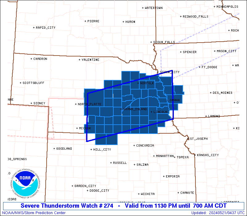
The severe thunderstorm watch area is approximately along and 65
statute miles north and south of a line from 60 miles south
southwest of Broken Bow NE to 20 miles northeast of Omaha NE. For a
complete depiction of the watch see the associated watch outline
update (WOUS64 KWNS WOU4).
PRECAUTIONARY/PREPAREDNESS ACTIONS...
REMEMBER...A Severe Thunderstorm Watch means conditions are
favorable for severe thunderstorms in and close to the watch area.
Persons in these areas should be on the lookout for threatening
weather conditions and listen for later statements and possible
warnings. Severe thunderstorms can and occasionally do produce
tornadoes.
&&
OTHER WATCH INFORMATION...This severe thunderstorm watch replaces
severe thunderstorm watch number 271. Watch number 271 will not
be in effect after 1130 PM CDT. CONTINUE...WW 269...WW 272...WW
273...
AVIATION...A few severe thunderstorms with hail surface and aloft to
1.5 inches. Extreme turbulence and surface wind gusts to 65 knots. A
few cumulonimbi with maximum tops to 500. Mean storm motion vector
25035.
...Thompson
   SEL4

   URGENT - IMMEDIATE BROADCAST REQUESTED
   Severe Thunderstorm Watch Number 274
   NWS Storm Prediction Center Norman OK
   1130 PM CDT Mon May 20 2024

   The NWS Storm Prediction Center has issued a

   * Severe Thunderstorm Watch for portions of
     Extreme western Iowa
     Extreme north central Kansas
     Central into eastern Nebraska

   * Effective this Monday night and Tuesday morning from 1130 PM
     until 700 AM CDT.

   * Primary threats include...
     Widespread damaging winds and isolated significant gusts to 75
       mph likely
     Scattered large hail events to 1.5 inches in diameter likely
     A tornado or two possible

   SUMMARY...Ongoing storms with a hail/wind threat may persist for a
   couple more hours across eastern Nebraska/western Iowa, while storms
   well to the west will grow upscale into a larger/bowing convective
   system overnight into central then eastern Nebraska.  Damaging wind
   swaths up to 75 mph will be the main threat, along with large hail
   up to 1.5 inches in diameter and a tornado or two with embedded
   circulations.

   The severe thunderstorm watch area is approximately along and 65
   statute miles north and south of a line from 60 miles south
   southwest of Broken Bow NE to 20 miles northeast of Omaha NE. For a
   complete depiction of the watch see the associated watch outline
   update (WOUS64 KWNS WOU4).

   PRECAUTIONARY/PREPAREDNESS ACTIONS...

   REMEMBER...A Severe Thunderstorm Watch means conditions are
   favorable for severe thunderstorms in and close to the watch area.
   Persons in these areas should be on the lookout for threatening
   weather conditions and listen for later statements and possible
   warnings. Severe thunderstorms can and occasionally do produce
   tornadoes.

   &&

   OTHER WATCH INFORMATION...This severe thunderstorm watch replaces
   severe thunderstorm watch number 271. Watch number 271 will not
   be in effect after 1130 PM CDT. CONTINUE...WW 269...WW 272...WW
   273...

   AVIATION...A few severe thunderstorms with hail surface and aloft to
   1.5 inches. Extreme turbulence and surface wind gusts to 65 knots. A
   few cumulonimbi with maximum tops to 500. Mean storm motion vector
   25035.

   ...Thompson
 Note:
The Aviation Watch (SAW) product is an approximation to the watch area.
The actual watch is depicted by the shaded areas.
Note:
The Aviation Watch (SAW) product is an approximation to the watch area.
The actual watch is depicted by the shaded areas.
   SAW4
   WW 274 SEVERE TSTM IA KS NE 210430Z - 211200Z
   AXIS..65 STATUTE MILES NORTH AND SOUTH OF LINE..
   60SSW BBW/BROKEN BOW NE/ - 20NE OMA/OMAHA NE/
   ..AVIATION COORDS.. 55NM N/S /35NE MCK - 21NNE OVR/
   HAIL SURFACE AND ALOFT..1.5 INCHES. WIND GUSTS..65 KNOTS.
   MAX TOPS TO 500. MEAN STORM MOTION VECTOR 25035.

   REPLACES WW 271..IA NE

   LAT...LON 41570007 42459563 40569563 39680007

   THIS IS AN APPROXIMATION TO THE WATCH AREA.  FOR A
   COMPLETE DEPICTION OF THE WATCH SEE WOUS64 KWNS
   FOR WOU4.
Watch 274 Status Report Messages:
STATUS REPORT #4 ON WW 274

VALID 211035Z - 211140Z

SEVERE WEATHER THREAT CONTINUES RIGHT OF A LINE FROM 40 WSW BIE
TO 10 E OLU TO 10 WNW OFK.

..GOSS..05/21/24

ATTN...WFO...OAX...GID...LBF...

&&

STATUS REPORT FOR WS 274

SEVERE WEATHER THREAT CONTINUES FOR THE FOLLOWING AREAS

IAC085-129-133-155-165-211140-

IA
.    IOWA COUNTIES INCLUDED ARE

HARRISON	     MILLS		 MONONA
POTTAWATTAMIE	     SHELBY
$$


NEC021-023-025-037-039-053-055-067-095-097-109-119-131-139-151-
153-155-159-167-173-177-179-211140-

NE
.    NEBRASKA COUNTIES INCLUDED ARE

BURT		     BUTLER		 CASS
COLFAX		     CUMING		 DODGE
DOUGLAS 	     GAGE		 JEFFERSON
JOHNSON 	     LANCASTER		 MADISON
OTOE		     PIERCE		 SALINE
SARPY		     SAUNDERS		 SEWARD
STANTON 	     THURSTON		 WASHINGTON
WAYNE
$$


THE WATCH STATUS MESSAGE IS FOR GUIDANCE PURPOSES ONLY.  PLEASE
REFER TO WATCH COUNTY NOTIFICATION STATEMENTS FOR OFFICIAL
INFORMATION ON COUNTIES...INDEPENDENT CITIES AND MARINE ZONES
CLEARED FROM SEVERE THUNDERSTORM AND TORNADO WATCHES.
$$

STATUS REPORT #3 ON WW 274

VALID 210900Z - 211040Z

SEVERE WEATHER THREAT CONTINUES RIGHT OF A LINE FROM 40 NE HLC TO
5 NE BUB.

..GOSS..05/21/24

ATTN...WFO...OAX...GID...LBF...

&&

STATUS REPORT FOR WS 274

SEVERE WEATHER THREAT CONTINUES FOR THE FOLLOWING AREAS

IAC085-129-133-155-165-211040-

IA
.    IOWA COUNTIES INCLUDED ARE

HARRISON	     MILLS		 MONONA
POTTAWATTAMIE	     SHELBY
$$


KSC183-211040-

KS
.    KANSAS COUNTIES INCLUDED ARE

SMITH
$$


NEC001-003-011-019-021-023-025-035-037-039-053-055-059-061-067-
071-077-079-081-093-095-097-099-109-119-121-125-129-131-139-141-
143-151-153-155-159-163-167-169-173-175-177-179-181-183-185-
211040-

NE
.    NEBRASKA COUNTIES INCLUDED ARE

ADAMS		     ANTELOPE		 BOONE
BUFFALO 	     BURT		 BUTLER
CASS		     CLAY		 COLFAX
CUMING		     DODGE		 DOUGLAS
FILLMORE	     FRANKLIN		 GAGE
GARFIELD	     GREELEY		 HALL
HAMILTON	     HOWARD		 JEFFERSON
JOHNSON 	     KEARNEY		 LANCASTER
MADISON 	     MERRICK		 NANCE
NUCKOLLS	     OTOE		 PIERCE
PLATTE		     POLK		 SALINE
SARPY		     SAUNDERS		 SEWARD
SHERMAN 	     STANTON		 THAYER
THURSTON	     VALLEY		 WASHINGTON
WAYNE		     WEBSTER		 WHEELER
YORK
$$


THE WATCH STATUS MESSAGE IS FOR GUIDANCE PURPOSES ONLY.  PLEASE
REFER TO WATCH COUNTY NOTIFICATION STATEMENTS FOR OFFICIAL
INFORMATION ON COUNTIES...INDEPENDENT CITIES AND MARINE ZONES
CLEARED FROM SEVERE THUNDERSTORM AND TORNADO WATCHES.
$$

STATUS REPORT #2 ON WW 274

VALID 210630Z - 210740Z

THE SEVERE WEATHER THREAT CONTINUES ACROSS THE ENTIRE WATCH AREA.

..GOSS..05/21/24

ATTN...WFO...OAX...GID...LBF...

&&

STATUS REPORT FOR WS 274

SEVERE WEATHER THREAT CONTINUES FOR THE FOLLOWING AREAS

IAC085-129-133-155-165-210740-

IA
.    IOWA COUNTIES INCLUDED ARE

HARRISON	     MILLS		 MONONA
POTTAWATTAMIE	     SHELBY
$$


KSC147-183-210740-

KS
.    KANSAS COUNTIES INCLUDED ARE

PHILLIPS	     SMITH
$$


NEC001-003-011-019-021-023-025-035-037-039-041-047-053-055-059-
061-065-067-071-073-077-079-081-083-093-095-097-099-109-119-121-
125-129-131-137-139-141-143-151-153-155-159-163-167-169-173-175-
177-179-181-183-185-210740-

NE
.    NEBRASKA COUNTIES INCLUDED ARE

ADAMS		     ANTELOPE		 BOONE
BUFFALO 	     BURT		 BUTLER
CASS		     CLAY		 COLFAX
CUMING		     CUSTER		 DAWSON
DODGE		     DOUGLAS		 FILLMORE
FRANKLIN	     FURNAS		 GAGE
GARFIELD	     GOSPER		 GREELEY
HALL		     HAMILTON		 HARLAN
HOWARD		     JEFFERSON		 JOHNSON
KEARNEY 	     LANCASTER		 MADISON
MERRICK 	     NANCE		 NUCKOLLS
OTOE		     PHELPS		 PIERCE
PLATTE		     POLK		 SALINE
SARPY		     SAUNDERS		 SEWARD
SHERMAN 	     STANTON		 THAYER
THURSTON	     VALLEY		 WASHINGTON
WAYNE		     WEBSTER		 WHEELER
YORK
$$


THE WATCH STATUS MESSAGE IS FOR GUIDANCE PURPOSES ONLY.  PLEASE
REFER TO WATCH COUNTY NOTIFICATION STATEMENTS FOR OFFICIAL
INFORMATION ON COUNTIES...INDEPENDENT CITIES AND MARINE ZONES
CLEARED FROM SEVERE THUNDERSTORM AND TORNADO WATCHES.
$$

STATUS REPORT #1 ON WW 274

VALID 210555Z - 210640Z

THE SEVERE WEATHER THREAT CONTINUES ACROSS THE ENTIRE WATCH AREA.

..GOSS..05/21/24

ATTN...WFO...OAX...GID...LBF...

&&

STATUS REPORT FOR WS 274

SEVERE WEATHER THREAT CONTINUES FOR THE FOLLOWING AREAS

IAC085-129-133-155-165-210640-

IA
.    IOWA COUNTIES INCLUDED ARE

HARRISON	     MILLS		 MONONA
POTTAWATTAMIE	     SHELBY
$$


KSC147-183-210640-

KS
.    KANSAS COUNTIES INCLUDED ARE

PHILLIPS	     SMITH
$$


NEC001-003-011-019-021-023-025-035-037-039-041-047-053-055-059-
061-065-067-071-073-077-079-081-083-093-095-097-099-109-119-121-
125-129-131-137-139-141-143-151-153-155-159-163-167-169-173-175-
177-179-181-183-185-210640-

NE
.    NEBRASKA COUNTIES INCLUDED ARE

ADAMS		     ANTELOPE		 BOONE
BUFFALO 	     BURT		 BUTLER
CASS		     CLAY		 COLFAX
CUMING		     CUSTER		 DAWSON
DODGE		     DOUGLAS		 FILLMORE
FRANKLIN	     FURNAS		 GAGE
GARFIELD	     GOSPER		 GREELEY
HALL		     HAMILTON		 HARLAN
HOWARD		     JEFFERSON		 JOHNSON
KEARNEY 	     LANCASTER		 MADISON
MERRICK 	     NANCE		 NUCKOLLS
OTOE		     PHELPS		 PIERCE
PLATTE		     POLK		 SALINE
SARPY		     SAUNDERS		 SEWARD
SHERMAN 	     STANTON		 THAYER
THURSTON	     VALLEY		 WASHINGTON
WAYNE		     WEBSTER		 WHEELER
YORK
$$


THE WATCH STATUS MESSAGE IS FOR GUIDANCE PURPOSES ONLY.  PLEASE
REFER TO WATCH COUNTY NOTIFICATION STATEMENTS FOR OFFICIAL
INFORMATION ON COUNTIES...INDEPENDENT CITIES AND MARINE ZONES
CLEARED FROM SEVERE THUNDERSTORM AND TORNADO WATCHES.
$$
Note:
Click for Complete Product Text.
Tornadoes
Probability of 2 or more tornadoes
|
Low (20%)
|
Probability of 1 or more strong (EF2-EF5) tornadoes
|
Low (5%)
|
Wind
Probability of 10 or more severe wind events
|
High (80%)
|
Probability of 1 or more wind events > 65 knots
|
Mod (60%)
|
Hail
Probability of 10 or more severe hail events
|
Mod (60%)
|
Probability of 1 or more hailstones > 2 inches
|
Low (20%)
|
Combined Severe Hail/Wind
Probability of 6 or more combined severe hail/wind events
|
High (>95%)
|
For each watch, probabilities for particular events inside the watch
(listed above in each table) are determined by the issuing forecaster.
The "Low" category contains probability values ranging from less than 2%
to 20% (EF2-EF5 tornadoes), less than 5% to 20% (all other probabilities),
"Moderate" from 30% to 60%, and "High" from 70% to greater than 95%.
High values are bolded and lighter in color to provide awareness of
an increased threat for a particular event.


 @NWSSPC