 Note:
The expiration time in the watch graphic is amended if the watch is
replaced, cancelled or extended.
Note:
Note:
The expiration time in the watch graphic is amended if the watch is
replaced, cancelled or extended.
Note: Click for
Watch Status Reports.
SEL3
URGENT - IMMEDIATE BROADCAST REQUESTED
Tornado Watch Number 273
NWS Storm Prediction Center Norman OK
855 PM CDT Mon May 20 2024
The NWS Storm Prediction Center has issued a
* Tornado Watch for portions of
Extreme northeast Colorado
Extreme northwest Kansas
Southwest Nebraska
* Effective this Monday night and Tuesday morning from 855 PM
until 300 AM CDT.
* Primary threats include...
A few tornadoes likely with a couple intense tornadoes possible
Scattered damaging winds and isolated significant gusts to 80
mph likely
Scattered large hail and isolated very large hail events to 3
inches in diameter likely
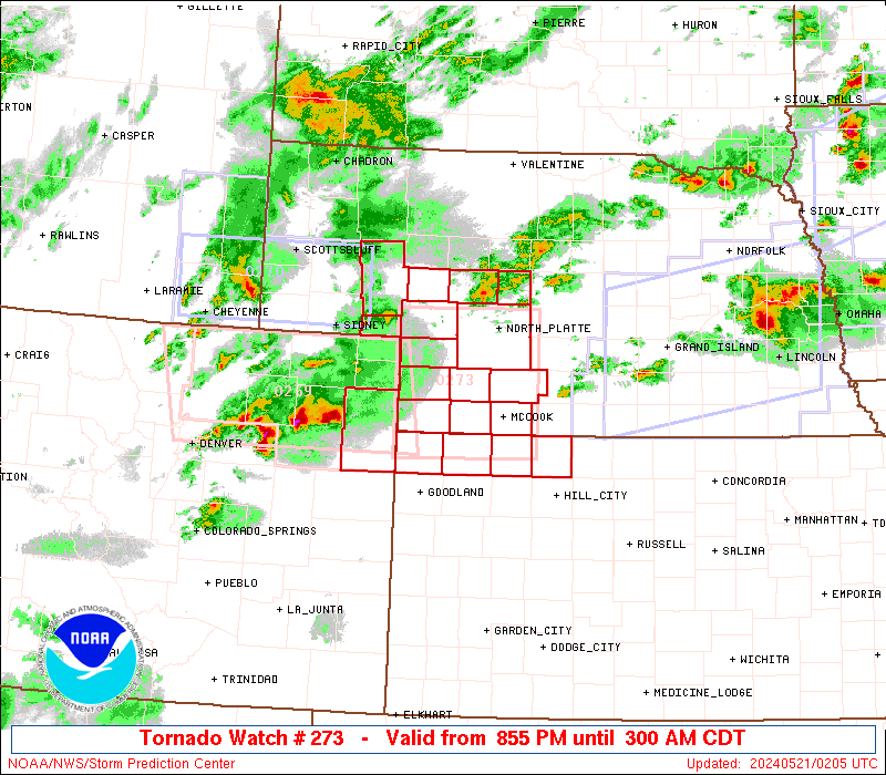
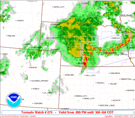
SUMMARY...Clusters of intensifying supercells across northeast
Colorado will continue eastward into Kansas/Nebraska with some
potential for upscale growth tonight. The storm environment will
favor all significant hazards of all types (tornadoes capable of EF2
damage, very large hail up to 3 inches in diameter, and severe
outflow winds up to 80 mph).
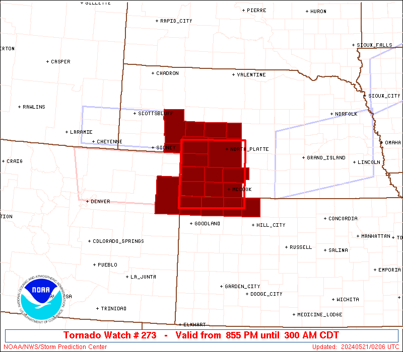
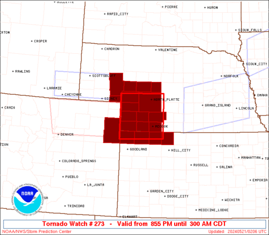
The tornado watch area is approximately along and 55 statute miles
north and south of a line from 25 miles west of Imperial NE to 35
miles northeast of Mccook NE. For a complete depiction of the watch
see the associated watch outline update (WOUS64 KWNS WOU3).
PRECAUTIONARY/PREPAREDNESS ACTIONS...
REMEMBER...A Tornado Watch means conditions are favorable for
tornadoes and severe thunderstorms in and close to the watch
area. Persons in these areas should be on the lookout for
threatening weather conditions and listen for later statements
and possible warnings.
&&
OTHER WATCH INFORMATION...CONTINUE...WW 268...WW 269...WW
270...WW 271...WW 272...
AVIATION...Tornadoes and a few severe thunderstorms with hail
surface and aloft to 3 inches. Extreme turbulence and surface wind
gusts to 70 knots. A few cumulonimbi with maximum tops to 500. Mean
storm motion vector 27030.
...Thompson

   SEL3

   URGENT - IMMEDIATE BROADCAST REQUESTED
   Tornado Watch Number 273
   NWS Storm Prediction Center Norman OK
   855 PM CDT Mon May 20 2024

   The NWS Storm Prediction Center has issued a

   * Tornado Watch for portions of
     Extreme northeast Colorado
     Extreme northwest Kansas
     Southwest Nebraska

   * Effective this Monday night and Tuesday morning from 855 PM
     until 300 AM CDT.

   * Primary threats include...
     A few tornadoes likely with a couple intense tornadoes possible
     Scattered damaging winds and isolated significant gusts to 80
       mph likely
     Scattered large hail and isolated very large hail events to 3
       inches in diameter likely

   SUMMARY...Clusters of intensifying supercells across northeast
   Colorado will continue eastward into Kansas/Nebraska with some
   potential for upscale growth tonight.  The storm environment will
   favor all significant hazards of all types (tornadoes capable of EF2
   damage, very large hail up to 3 inches in diameter, and severe
   outflow winds up to 80 mph).

   The tornado watch area is approximately along and 55 statute miles
   north and south of a line from 25 miles west of Imperial NE to 35
   miles northeast of Mccook NE. For a complete depiction of the watch
   see the associated watch outline update (WOUS64 KWNS WOU3).

   PRECAUTIONARY/PREPAREDNESS ACTIONS...

   REMEMBER...A Tornado Watch means conditions are favorable for
   tornadoes and severe thunderstorms in and close to the watch
   area. Persons in these areas should be on the lookout for
   threatening weather conditions and listen for later statements
   and possible warnings.

   &&

   OTHER WATCH INFORMATION...CONTINUE...WW 268...WW 269...WW
   270...WW 271...WW 272...

   AVIATION...Tornadoes and a few severe thunderstorms with hail
   surface and aloft to 3 inches. Extreme turbulence and surface wind
   gusts to 70 knots. A few cumulonimbi with maximum tops to 500. Mean
   storm motion vector 27030.

   ...Thompson
 Note:
The Aviation Watch (SAW) product is an approximation to the watch area.
The actual watch is depicted by the shaded areas.
Note:
The Aviation Watch (SAW) product is an approximation to the watch area.
The actual watch is depicted by the shaded areas.
   SAW3
   WW 273 TORNADO CO KS NE 210155Z - 210800Z
   AXIS..55 STATUTE MILES NORTH AND SOUTH OF LINE..
   25W IML/IMPERIAL NE/ - 35NE MCK/MCCOOK NE/
   ..AVIATION COORDS.. 50NM N/S /53SE SNY - 31NE MCK/
   HAIL SURFACE AND ALOFT..3 INCHES. WIND GUSTS..70 KNOTS.
   MAX TOPS TO 500. MEAN STORM MOTION VECTOR 27030.

   LAT...LON 41320210 41350011 39750011 39720210

   THIS IS AN APPROXIMATION TO THE WATCH AREA.  FOR A
   COMPLETE DEPICTION OF THE WATCH SEE WOUS64 KWNS
   FOR WOU3.
Watch 273 Status Report Messages:
STATUS REPORT #3 ON WW 273

VALID 210630Z - 210740Z

SEVERE WEATHER THREAT CONTINUES RIGHT OF A LINE FROM 30 NNE ITR
TO 30 SSE IML TO 10 ESE IML TO 35 ESE LBF.

..GOSS..05/21/24

ATTN...WFO...GLD...LBF...

&&

STATUS REPORT FOR WT 273

SEVERE WEATHER THREAT CONTINUES FOR THE FOLLOWING AREAS

KSC023-039-137-153-210740-

KS
.    KANSAS COUNTIES INCLUDED ARE

CHEYENNE	     DECATUR		 NORTON
RAWLINS
$$


NEC063-085-087-145-210740-

NE
.    NEBRASKA COUNTIES INCLUDED ARE

FRONTIER	     HAYES		 HITCHCOCK
RED WILLOW
$$


THE WATCH STATUS MESSAGE IS FOR GUIDANCE PURPOSES ONLY.  PLEASE
REFER TO WATCH COUNTY NOTIFICATION STATEMENTS FOR OFFICIAL
INFORMATION ON COUNTIES...INDEPENDENT CITIES AND MARINE ZONES
CLEARED FROM SEVERE THUNDERSTORM AND TORNADO WATCHES.
$$

STATUS REPORT #2 ON WW 273

VALID 210555Z - 210640Z

SEVERE WEATHER THREAT CONTINUES RIGHT OF A LINE FROM 35 SSE AKO
TO 35 SW IML TO 5 WSW IML TO 30 ENE IML TO 35 WNW BBW.

..GOSS..05/21/24

ATTN...WFO...GLD...LBF...

&&

STATUS REPORT FOR WT 273

SEVERE WEATHER THREAT CONTINUES FOR THE FOLLOWING AREAS

COC125-210640-

CO
.    COLORADO COUNTIES INCLUDED ARE

YUMA
$$


KSC023-039-137-153-210640-

KS
.    KANSAS COUNTIES INCLUDED ARE

CHEYENNE	     DECATUR		 NORTON
RAWLINS
$$


NEC029-057-063-085-087-111-145-210640-

NE
.    NEBRASKA COUNTIES INCLUDED ARE

CHASE		     DUNDY		 FRONTIER
HAYES		     HITCHCOCK		 LINCOLN
RED WILLOW
$$


THE WATCH STATUS MESSAGE IS FOR GUIDANCE PURPOSES ONLY.  PLEASE
REFER TO WATCH COUNTY NOTIFICATION STATEMENTS FOR OFFICIAL
INFORMATION ON COUNTIES...INDEPENDENT CITIES AND MARINE ZONES
CLEARED FROM SEVERE THUNDERSTORM AND TORNADO WATCHES.
$$

STATUS REPORT #1 ON WW 273

VALID 210445Z - 210540Z

THE SEVERE WEATHER THREAT CONTINUES ACROSS THE ENTIRE WATCH AREA.

..KERR..05/21/24

ATTN...WFO...GLD...LBF...

&&

STATUS REPORT FOR WT 273

SEVERE WEATHER THREAT CONTINUES FOR THE FOLLOWING AREAS

COC125-210540-

CO
.    COLORADO COUNTIES INCLUDED ARE

YUMA
$$


KSC023-039-137-153-210540-

KS
.    KANSAS COUNTIES INCLUDED ARE

CHEYENNE	     DECATUR		 NORTON
RAWLINS
$$


NEC005-029-049-057-063-069-085-087-101-111-113-117-135-145-
210540-

NE
.    NEBRASKA COUNTIES INCLUDED ARE

ARTHUR		     CHASE		 DEUEL
DUNDY		     FRONTIER		 GARDEN
HAYES		     HITCHCOCK		 KEITH
LINCOLN 	     LOGAN		 MCPHERSON
PERKINS 	     RED WILLOW
$$


THE WATCH STATUS MESSAGE IS FOR GUIDANCE PURPOSES ONLY.  PLEASE
REFER TO WATCH COUNTY NOTIFICATION STATEMENTS FOR OFFICIAL
INFORMATION ON COUNTIES...INDEPENDENT CITIES AND MARINE ZONES
CLEARED FROM SEVERE THUNDERSTORM AND TORNADO WATCHES.
$$
Note:
Click for Complete Product Text.
Tornadoes
Probability of 2 or more tornadoes
|
Mod (60%)
|
Probability of 1 or more strong (EF2-EF5) tornadoes
|
Mod (30%)
|
Wind
Probability of 10 or more severe wind events
|
High (70%)
|
Probability of 1 or more wind events > 65 knots
|
High (70%)
|
Hail
Probability of 10 or more severe hail events
|
High (70%)
|
Probability of 1 or more hailstones > 2 inches
|
High (70%)
|
Combined Severe Hail/Wind
Probability of 6 or more combined severe hail/wind events
|
High (>95%)
|
For each watch, probabilities for particular events inside the watch
(listed above in each table) are determined by the issuing forecaster.
The "Low" category contains probability values ranging from less than 2%
to 20% (EF2-EF5 tornadoes), less than 5% to 20% (all other probabilities),
"Moderate" from 30% to 60%, and "High" from 70% to greater than 95%.
High values are bolded and lighter in color to provide awareness of
an increased threat for a particular event.


 @NWSSPC