 Note:
The expiration time in the watch graphic is amended if the watch is
replaced, cancelled or extended.
Note:
Note:
The expiration time in the watch graphic is amended if the watch is
replaced, cancelled or extended.
Note: Click for
Watch Status Reports.
SEL2
URGENT - IMMEDIATE BROADCAST REQUESTED
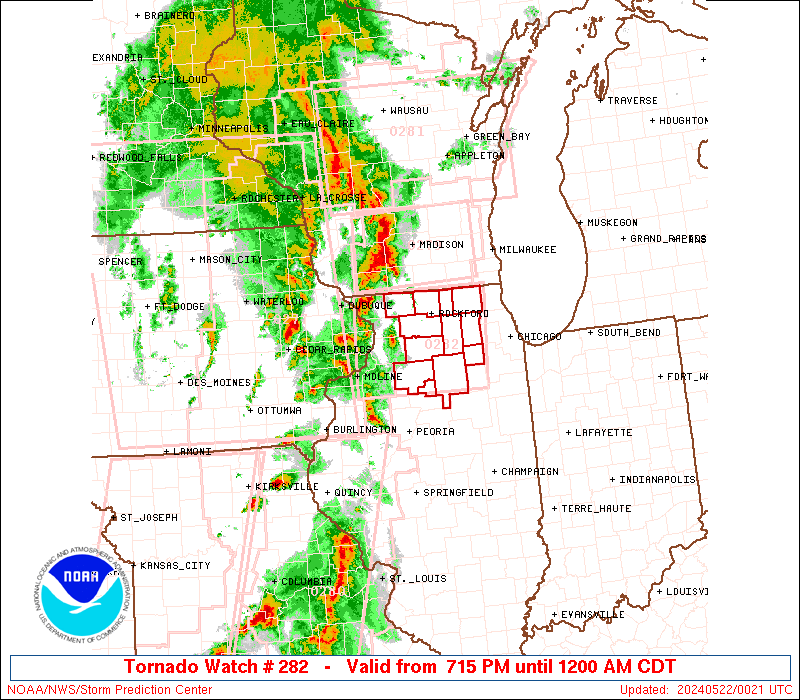
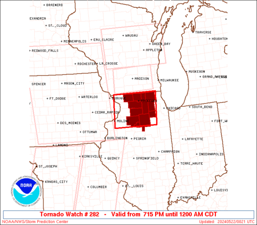
Tornado Watch Number 282
NWS Storm Prediction Center Norman OK
715 PM CDT Tue May 21 2024
The NWS Storm Prediction Center has issued a
* Tornado Watch for portions of
Northern Illinois
* Effective this Tuesday night from 715 PM until Midnight CDT.
* Primary threats include...
A few tornadoes possible
Scattered damaging winds likely with isolated significant gusts
to 75 mph possible
Isolated large hail events to 1 inch in diameter possible
SUMMARY...Severe storms will spread northeastward through early
tonight, with a continued threat for a few tornadoes, damaging gusts
of 60-75 mph and isolated large hail near 1 inch in diameter.
The tornado watch area is approximately along and 60 statute miles
east and west of a line from 25 miles north northwest of Rockford IL
to 40 miles west southwest of Marseilles IL. For a complete
depiction of the watch see the associated watch outline update
(WOUS64 KWNS WOU2).
PRECAUTIONARY/PREPAREDNESS ACTIONS...
REMEMBER...A Tornado Watch means conditions are favorable for
tornadoes and severe thunderstorms in and close to the watch
area. Persons in these areas should be on the lookout for
threatening weather conditions and listen for later statements
and possible warnings.
&&
OTHER WATCH INFORMATION...CONTINUE...WW 277...WW 278...WW
279...WW 280...WW 281...
AVIATION...Tornadoes and a few severe thunderstorms with hail
surface and aloft to 1 inch. Extreme turbulence and surface wind
gusts to 65 knots. A few cumulonimbi with maximum tops to 500. Mean
storm motion vector 24045.
...Thompson

   SEL2

   URGENT - IMMEDIATE BROADCAST REQUESTED
   Tornado Watch Number 282
   NWS Storm Prediction Center Norman OK
   715 PM CDT Tue May 21 2024

   The NWS Storm Prediction Center has issued a

   * Tornado Watch for portions of
     Northern Illinois

   * Effective this Tuesday night from 715 PM until Midnight CDT.

   * Primary threats include...
     A few tornadoes possible
     Scattered damaging winds likely with isolated significant gusts
       to 75 mph possible
     Isolated large hail events to 1 inch in diameter possible

   SUMMARY...Severe storms will spread northeastward through early
   tonight, with a continued threat for a few tornadoes, damaging gusts
   of 60-75 mph and isolated large hail near 1 inch in diameter.

   The tornado watch area is approximately along and 60 statute miles
   east and west of a line from 25 miles north northwest of Rockford IL
   to 40 miles west southwest of Marseilles IL. For a complete
   depiction of the watch see the associated watch outline update
   (WOUS64 KWNS WOU2).

   PRECAUTIONARY/PREPAREDNESS ACTIONS...

   REMEMBER...A Tornado Watch means conditions are favorable for
   tornadoes and severe thunderstorms in and close to the watch
   area. Persons in these areas should be on the lookout for
   threatening weather conditions and listen for later statements
   and possible warnings.

   &&

   OTHER WATCH INFORMATION...CONTINUE...WW 277...WW 278...WW
   279...WW 280...WW 281...

   AVIATION...Tornadoes and a few severe thunderstorms with hail
   surface and aloft to 1 inch. Extreme turbulence and surface wind
   gusts to 65 knots. A few cumulonimbi with maximum tops to 500. Mean
   storm motion vector 24045.

   ...Thompson
 Note:
The Aviation Watch (SAW) product is an approximation to the watch area.
The actual watch is depicted by the shaded areas.
Note:
The Aviation Watch (SAW) product is an approximation to the watch area.
The actual watch is depicted by the shaded areas.
   SAW2
   WW 282 TORNADO IL 220015Z - 220500Z
   AXIS..60 STATUTE MILES EAST AND WEST OF LINE..
   25NNW RFD/ROCKFORD IL/ - 40WSW MMO/MARSEILLES IL/
   ..AVIATION COORDS.. 50NM E/W /57SW BAE - 9E BDF/
   HAIL SURFACE AND ALOFT..1 INCH. WIND GUSTS..65 KNOTS.
   MAX TOPS TO 500. MEAN STORM MOTION VECTOR 24045.

   LAT...LON 42538811 41148824 41149054 42539047

   THIS IS AN APPROXIMATION TO THE WATCH AREA.  FOR A
   COMPLETE DEPICTION OF THE WATCH SEE WOUS64 KWNS
   FOR WOU2.
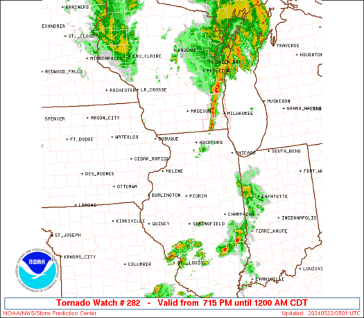
Watch 282 Status Report Messages:
STATUS REPORT #4 ON WW 282

VALID 220450Z - 220500Z

SEVERE WEATHER THREAT CONTINUES RIGHT OF A LINE FROM 30 WSW MMO
TO 25 ESE JVL.

WW 282 MAY BE ALLOWED TO EXPIRE AT 22/05Z.

..KERR..05/22/24

ATTN...WFO...LOT...DVN...

&&

STATUS REPORT FOR WT 282

SEVERE WEATHER THREAT CONTINUES FOR THE FOLLOWING AREAS

ILC037-089-093-099-111-220500-

IL
.    ILLINOIS COUNTIES INCLUDED ARE

DE KALB 	     KANE		 KENDALL
LA SALLE	     MCHENRY
$$


THE WATCH STATUS MESSAGE IS FOR GUIDANCE PURPOSES ONLY.  PLEASE
REFER TO WATCH COUNTY NOTIFICATION STATEMENTS FOR OFFICIAL
INFORMATION ON COUNTIES...INDEPENDENT CITIES AND MARINE ZONES
CLEARED FROM SEVERE THUNDERSTORM AND TORNADO WATCHES.
$$

STATUS REPORT #3 ON WW 282

VALID 220345Z - 220440Z

SEVERE WEATHER THREAT CONTINUES RIGHT OF A LINE FROM 35 N PIA TO
20 W JVL.

..KERR..05/22/24

ATTN...WFO...LOT...DVN...

&&

STATUS REPORT FOR WT 282

SEVERE WEATHER THREAT CONTINUES FOR THE FOLLOWING AREAS

ILC007-011-037-089-093-099-103-111-141-155-177-201-220440-

IL
.    ILLINOIS COUNTIES INCLUDED ARE

BOONE		     BUREAU		 DE KALB
KANE		     KENDALL		 LA SALLE
LEE		     MCHENRY		 OGLE
PUTNAM		     STEPHENSON 	 WINNEBAGO
$$


THE WATCH STATUS MESSAGE IS FOR GUIDANCE PURPOSES ONLY.  PLEASE
REFER TO WATCH COUNTY NOTIFICATION STATEMENTS FOR OFFICIAL
INFORMATION ON COUNTIES...INDEPENDENT CITIES AND MARINE ZONES
CLEARED FROM SEVERE THUNDERSTORM AND TORNADO WATCHES.
$$

STATUS REPORT #2 ON WW 282

VALID 220210Z - 220340Z

THE SEVERE WEATHER THREAT CONTINUES ACROSS THE ENTIRE WATCH AREA.

..BENTLEY..05/22/24

ATTN...WFO...LOT...DVN...

&&

STATUS REPORT FOR WT 282

SEVERE WEATHER THREAT CONTINUES FOR THE FOLLOWING AREAS

ILC007-011-037-089-093-099-103-111-141-155-177-201-220340-

IL
.    ILLINOIS COUNTIES INCLUDED ARE

BOONE		     BUREAU		 DE KALB
KANE		     KENDALL		 LA SALLE
LEE		     MCHENRY		 OGLE
PUTNAM		     STEPHENSON 	 WINNEBAGO
$$


THE WATCH STATUS MESSAGE IS FOR GUIDANCE PURPOSES ONLY.  PLEASE
REFER TO WATCH COUNTY NOTIFICATION STATEMENTS FOR OFFICIAL
INFORMATION ON COUNTIES...INDEPENDENT CITIES AND MARINE ZONES
CLEARED FROM SEVERE THUNDERSTORM AND TORNADO WATCHES.
$$

STATUS REPORT #1 ON WW 282

VALID 220035Z - 220140Z

THE SEVERE WEATHER THREAT CONTINUES ACROSS THE ENTIRE WATCH AREA.

..HART..05/22/24

ATTN...WFO...LOT...DVN...

&&

STATUS REPORT FOR WT 282

SEVERE WEATHER THREAT CONTINUES FOR THE FOLLOWING AREAS

ILC007-011-037-089-093-099-103-111-141-155-177-201-220140-

IL
.    ILLINOIS COUNTIES INCLUDED ARE

BOONE		     BUREAU		 DE KALB
KANE		     KENDALL		 LA SALLE
LEE		     MCHENRY		 OGLE
PUTNAM		     STEPHENSON 	 WINNEBAGO
$$


THE WATCH STATUS MESSAGE IS FOR GUIDANCE PURPOSES ONLY.  PLEASE
REFER TO WATCH COUNTY NOTIFICATION STATEMENTS FOR OFFICIAL
INFORMATION ON COUNTIES...INDEPENDENT CITIES AND MARINE ZONES
CLEARED FROM SEVERE THUNDERSTORM AND TORNADO WATCHES.
$$
Note:
Click for Complete Product Text.
Tornadoes
Probability of 2 or more tornadoes
|
Mod (50%)
|
Probability of 1 or more strong (EF2-EF5) tornadoes
|
Low (20%)
|
Wind
Probability of 10 or more severe wind events
|
Mod (60%)
|
Probability of 1 or more wind events > 65 knots
|
Mod (30%)
|
Hail
Probability of 10 or more severe hail events
|
Mod (30%)
|
Probability of 1 or more hailstones > 2 inches
|
Low (<5%)
|
Combined Severe Hail/Wind
Probability of 6 or more combined severe hail/wind events
|
High (80%)
|
For each watch, probabilities for particular events inside the watch
(listed above in each table) are determined by the issuing forecaster.
The "Low" category contains probability values ranging from less than 2%
to 20% (EF2-EF5 tornadoes), less than 5% to 20% (all other probabilities),
"Moderate" from 30% to 60%, and "High" from 70% to greater than 95%.
High values are bolded and lighter in color to provide awareness of
an increased threat for a particular event.


 @NWSSPC