 Note:
The expiration time in the watch graphic is amended if the watch is
replaced, cancelled or extended.
Note:
Note:
The expiration time in the watch graphic is amended if the watch is
replaced, cancelled or extended.
Note: Click for
Watch Status Reports.
SEL7
URGENT - IMMEDIATE BROADCAST REQUESTED
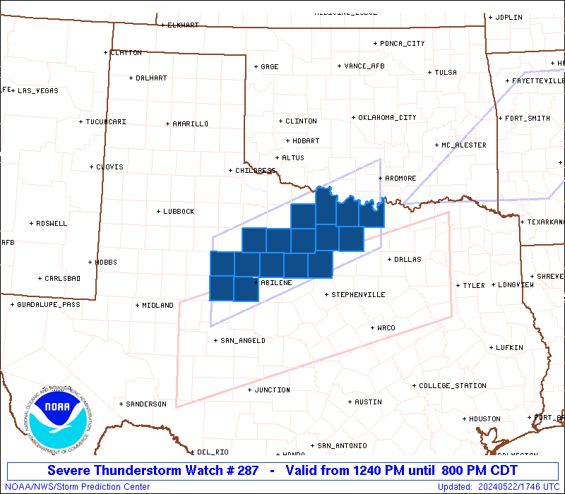
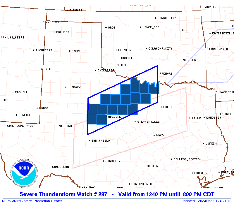
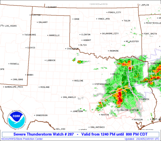
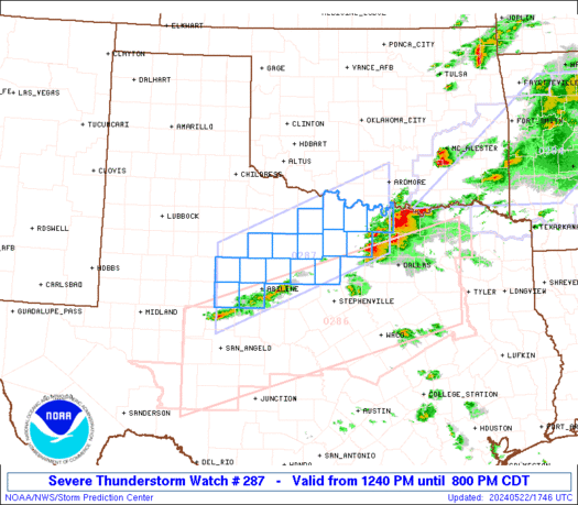
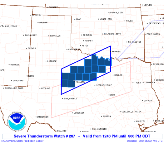
Severe Thunderstorm Watch Number 287
NWS Storm Prediction Center Norman OK
1240 PM CDT Wed May 22 2024
The NWS Storm Prediction Center has issued a
* Severe Thunderstorm Watch for portions of
Northwest Texas
* Effective this Wednesday afternoon and evening from 1240 PM
until 800 PM CDT.
* Primary threats include...
Scattered large hail and isolated very large hail events to 3
inches in diameter likely
Scattered damaging wind gusts to 70 mph possible
A tornado or two possible
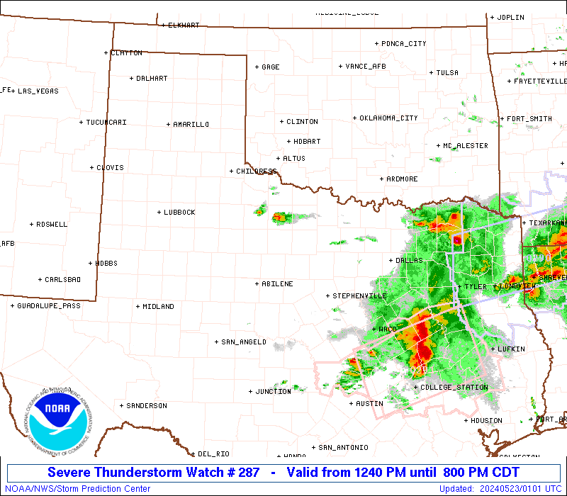
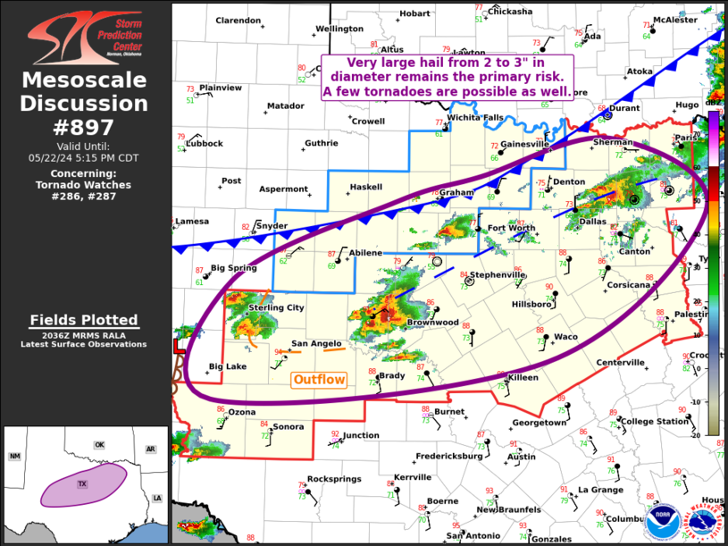
SUMMARY...Thunderstorms that form over north-central Texas this
afternoon could spread into the watch area, posing a risk of very
large hail and damaging winds.
The severe thunderstorm watch area is approximately along and 55
statute miles north and south of a line from 55 miles west of
Abilene TX to 30 miles south of Ardmore OK. For a complete depiction
of the watch see the associated watch outline update (WOUS64 KWNS
WOU7).
PRECAUTIONARY/PREPAREDNESS ACTIONS...
REMEMBER...A Severe Thunderstorm Watch means conditions are
favorable for severe thunderstorms in and close to the watch area.
Persons in these areas should be on the lookout for threatening
weather conditions and listen for later statements and possible
warnings. Severe thunderstorms can and occasionally do produce
tornadoes.
&&
OTHER WATCH INFORMATION...CONTINUE...WW 284...WW 285...WW 286...
AVIATION...A few severe thunderstorms with hail surface and aloft to
3 inches. Extreme turbulence and surface wind gusts to 60 knots. A
few cumulonimbi with maximum tops to 500. Mean storm motion vector
25030.
...Hart
   SEL7

   URGENT - IMMEDIATE BROADCAST REQUESTED
   Severe Thunderstorm Watch Number 287
   NWS Storm Prediction Center Norman OK
   1240 PM CDT Wed May 22 2024

   The NWS Storm Prediction Center has issued a

   * Severe Thunderstorm Watch for portions of
     Northwest Texas

   * Effective this Wednesday afternoon and evening from 1240 PM
     until 800 PM CDT.

   * Primary threats include...
     Scattered large hail and isolated very large hail events to 3
       inches in diameter likely
     Scattered damaging wind gusts to 70 mph possible
     A tornado or two possible

   SUMMARY...Thunderstorms that form over north-central Texas this
   afternoon could spread into the watch area, posing a risk of very
   large hail and damaging winds.

   The severe thunderstorm watch area is approximately along and 55
   statute miles north and south of a line from 55 miles west of
   Abilene TX to 30 miles south of Ardmore OK. For a complete depiction
   of the watch see the associated watch outline update (WOUS64 KWNS
   WOU7).

   PRECAUTIONARY/PREPAREDNESS ACTIONS...

   REMEMBER...A Severe Thunderstorm Watch means conditions are
   favorable for severe thunderstorms in and close to the watch area.
   Persons in these areas should be on the lookout for threatening
   weather conditions and listen for later statements and possible
   warnings. Severe thunderstorms can and occasionally do produce
   tornadoes.

   &&

   OTHER WATCH INFORMATION...CONTINUE...WW 284...WW 285...WW 286...

   AVIATION...A few severe thunderstorms with hail surface and aloft to
   3 inches. Extreme turbulence and surface wind gusts to 60 knots. A
   few cumulonimbi with maximum tops to 500. Mean storm motion vector
   25030.

   ...Hart
 Note:
The Aviation Watch (SAW) product is an approximation to the watch area.
The actual watch is depicted by the shaded areas.
Note:
The Aviation Watch (SAW) product is an approximation to the watch area.
The actual watch is depicted by the shaded areas.
   SAW7
   WW 287 SEVERE TSTM TX 221740Z - 230100Z
   AXIS..55 STATUTE MILES NORTH AND SOUTH OF LINE..
   55W ABI/ABILENE TX/ - 30S ADM/ARDMORE OK/
   ..AVIATION COORDS.. 50NM N/S /39W ABI - 23SSE ADM/
   HAIL SURFACE AND ALOFT..3 INCHES. WIND GUSTS..60 KNOTS.
   MAX TOPS TO 500. MEAN STORM MOTION VECTOR 25030.

   LAT...LON 33210062 34659702 33069702 31620062

   THIS IS AN APPROXIMATION TO THE WATCH AREA.  FOR A
   COMPLETE DEPICTION OF THE WATCH SEE WOUS64 KWNS
   FOR WOU7.
Watch 287 Status Report Messages:
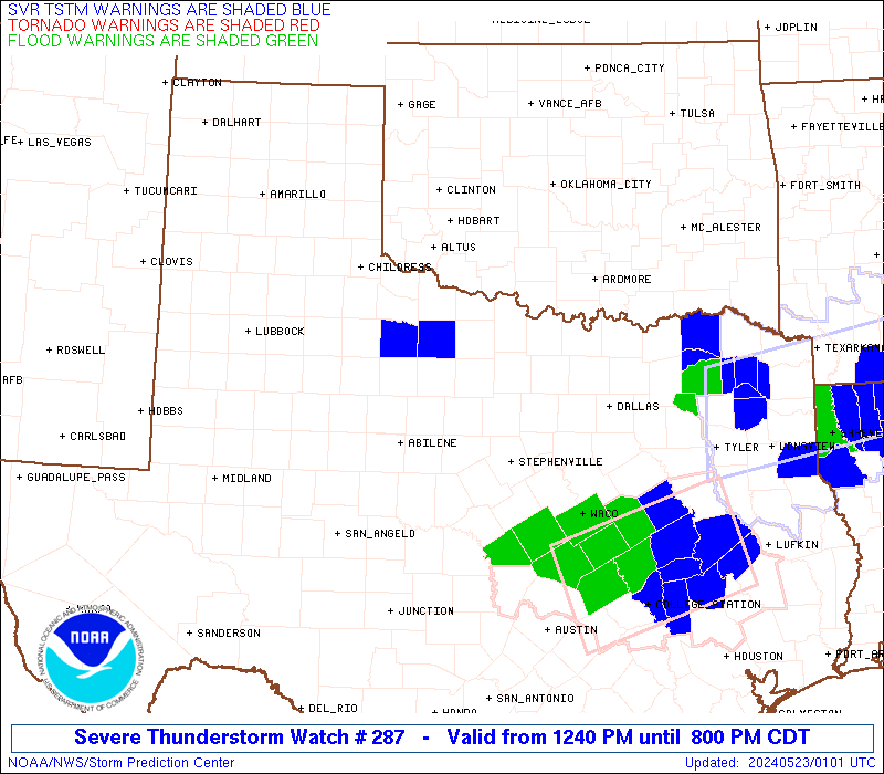
STATUS REPORT #6 ON WW 287

VALID 230000Z - 230100Z

SEVERE WEATHER THREAT CONTINUES RIGHT OF A LINE FROM 10 NW SPS TO
50 WNW MWL TO 35 NNW ABI TO 50 S CDS.

WW 287 WILL BE ALLOWED TO EXPIRE AT 230100Z.

..SQUITIERI..05/22/24

ATTN...WFO...OUN...FWD...SJT...

&&

STATUS REPORT FOR WS 287

SEVERE WEATHER THREAT CONTINUES FOR THE FOLLOWING AREAS

TXC009-207-447-230100-

TX
.    TEXAS COUNTIES INCLUDED ARE

ARCHER		     HASKELL		 THROCKMORTON
$$


THE WATCH STATUS MESSAGE IS FOR GUIDANCE PURPOSES ONLY.  PLEASE
REFER TO WATCH COUNTY NOTIFICATION STATEMENTS FOR OFFICIAL
INFORMATION ON COUNTIES...INDEPENDENT CITIES AND MARINE ZONES
CLEARED FROM SEVERE THUNDERSTORM AND TORNADO WATCHES.
$$

STATUS REPORT #5 ON WW 287

VALID 222255Z - 222340Z

SEVERE WEATHER THREAT CONTINUES RIGHT OF A LINE FROM 40 SSW ABI
TO 40 NW ABI TO 70 ESE LBB.

..SQUITIERI..05/22/24

ATTN...WFO...OUN...FWD...SJT...

&&

STATUS REPORT FOR WS 287

SEVERE WEATHER THREAT CONTINUES FOR THE FOLLOWING AREAS

TXC009-077-097-151-207-237-253-337-363-417-429-441-447-497-503-
222340-

TX
.    TEXAS COUNTIES INCLUDED ARE

ARCHER		     CLAY		 COOKE
FISHER		     HASKELL		 JACK
JONES		     MONTAGUE		 PALO PINTO
SHACKELFORD	     STEPHENS		 TAYLOR
THROCKMORTON	     WISE		 YOUNG
$$


THE WATCH STATUS MESSAGE IS FOR GUIDANCE PURPOSES ONLY.  PLEASE
REFER TO WATCH COUNTY NOTIFICATION STATEMENTS FOR OFFICIAL
INFORMATION ON COUNTIES...INDEPENDENT CITIES AND MARINE ZONES
CLEARED FROM SEVERE THUNDERSTORM AND TORNADO WATCHES.
$$

STATUS REPORT #4 ON WW 287

VALID 222245Z - 222340Z

THE SEVERE WEATHER THREAT CONTINUES ACROSS THE ENTIRE WATCH AREA.

..BROYLES..05/22/24

ATTN...WFO...OUN...FWD...SJT...

&&

STATUS REPORT FOR WS 287

SEVERE WEATHER THREAT CONTINUES FOR THE FOLLOWING AREAS

TXC009-077-097-151-207-237-253-337-353-363-417-429-441-447-497-
503-222340-

TX
.    TEXAS COUNTIES INCLUDED ARE

ARCHER		     CLAY		 COOKE
FISHER		     HASKELL		 JACK
JONES		     MONTAGUE		 NOLAN
PALO PINTO	     SHACKELFORD	 STEPHENS
TAYLOR		     THROCKMORTON	 WISE
YOUNG
$$


THE WATCH STATUS MESSAGE IS FOR GUIDANCE PURPOSES ONLY.  PLEASE
REFER TO WATCH COUNTY NOTIFICATION STATEMENTS FOR OFFICIAL
INFORMATION ON COUNTIES...INDEPENDENT CITIES AND MARINE ZONES
CLEARED FROM SEVERE THUNDERSTORM AND TORNADO WATCHES.
$$

STATUS REPORT #3 ON WW 287

VALID 222155Z - 222240Z

THE SEVERE WEATHER THREAT CONTINUES ACROSS THE ENTIRE WATCH AREA.

..BROYLES..05/22/24

ATTN...WFO...OUN...FWD...SJT...

&&

STATUS REPORT FOR WS 287

SEVERE WEATHER THREAT CONTINUES FOR THE FOLLOWING AREAS

TXC009-077-097-151-207-237-253-337-353-363-417-429-441-447-497-
503-222240-

TX
.    TEXAS COUNTIES INCLUDED ARE

ARCHER		     CLAY		 COOKE
FISHER		     HASKELL		 JACK
JONES		     MONTAGUE		 NOLAN
PALO PINTO	     SHACKELFORD	 STEPHENS
TAYLOR		     THROCKMORTON	 WISE
YOUNG
$$


THE WATCH STATUS MESSAGE IS FOR GUIDANCE PURPOSES ONLY.  PLEASE
REFER TO WATCH COUNTY NOTIFICATION STATEMENTS FOR OFFICIAL
INFORMATION ON COUNTIES...INDEPENDENT CITIES AND MARINE ZONES
CLEARED FROM SEVERE THUNDERSTORM AND TORNADO WATCHES.
$$

STATUS REPORT #2 ON WW 287

VALID 222150Z - 222240Z

THE SEVERE WEATHER THREAT CONTINUES ACROSS THE ENTIRE WATCH AREA.

..SQUITIERI..05/22/24

ATTN...WFO...OUN...FWD...SJT...

&&

STATUS REPORT FOR WS 287

SEVERE WEATHER THREAT CONTINUES FOR THE FOLLOWING AREAS

TXC009-077-097-151-207-237-253-337-353-363-417-429-441-447-497-
503-222240-

TX
.    TEXAS COUNTIES INCLUDED ARE

ARCHER		     CLAY		 COOKE
FISHER		     HASKELL		 JACK
JONES		     MONTAGUE		 NOLAN
PALO PINTO	     SHACKELFORD	 STEPHENS
TAYLOR		     THROCKMORTON	 WISE
YOUNG
$$


THE WATCH STATUS MESSAGE IS FOR GUIDANCE PURPOSES ONLY.  PLEASE
REFER TO WATCH COUNTY NOTIFICATION STATEMENTS FOR OFFICIAL
INFORMATION ON COUNTIES...INDEPENDENT CITIES AND MARINE ZONES
CLEARED FROM SEVERE THUNDERSTORM AND TORNADO WATCHES.
$$

STATUS REPORT #1 ON WW 287

VALID 222110Z - 222240Z

THE SEVERE WEATHER THREAT CONTINUES ACROSS THE ENTIRE WATCH AREA.

FOR ADDITIONAL INFORMATION SEE MESOSCALE DISCUSSION 897

..SQUITIERI..05/22/24

ATTN...WFO...OUN...FWD...SJT...

&&

STATUS REPORT FOR WS 287

SEVERE WEATHER THREAT CONTINUES FOR THE FOLLOWING AREAS

TXC009-077-097-151-207-237-253-337-353-363-417-429-441-447-497-
503-222240-

TX
.    TEXAS COUNTIES INCLUDED ARE

ARCHER		     CLAY		 COOKE
FISHER		     HASKELL		 JACK
JONES		     MONTAGUE		 NOLAN
PALO PINTO	     SHACKELFORD	 STEPHENS
TAYLOR		     THROCKMORTON	 WISE
YOUNG
$$


THE WATCH STATUS MESSAGE IS FOR GUIDANCE PURPOSES ONLY.  PLEASE
REFER TO WATCH COUNTY NOTIFICATION STATEMENTS FOR OFFICIAL
INFORMATION ON COUNTIES...INDEPENDENT CITIES AND MARINE ZONES
CLEARED FROM SEVERE THUNDERSTORM AND TORNADO WATCHES.
$$


 @NWSSPC