 Note:
The expiration time in the watch graphic is amended if the watch is
replaced, cancelled or extended.
Note:
Note:
The expiration time in the watch graphic is amended if the watch is
replaced, cancelled or extended.
Note: Click for
Watch Status Reports.
SEL6
URGENT - IMMEDIATE BROADCAST REQUESTED
Severe Thunderstorm Watch Number 386
NWS Storm Prediction Center Norman OK
445 PM CDT Mon Jun 3 2024
The NWS Storm Prediction Center has issued a
* Severe Thunderstorm Watch for portions of
Western Oklahoma
Northwest Texas and the Eastern Panhandle
* Effective this Monday afternoon and evening from 445 PM until
1100 PM CDT.
* Primary threats include...
Scattered large hail and isolated very large hail events to 3
inches in diameter likely
Scattered damaging wind gusts to 70 mph likely
A tornado or two possible
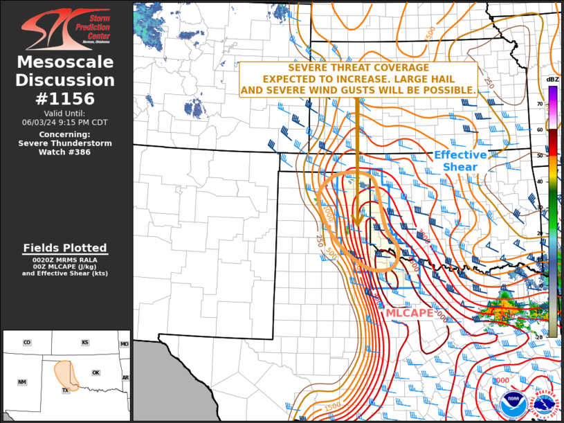
SUMMARY...Isolated intense supercell thunderstorms are expected to
develop this afternoon, capable of very large hail and damaging wind
gusts. An tornado or two is also possible.
The severe thunderstorm watch area is approximately along and 35
statute miles east and west of a line from 140 miles north northwest
of Altus OK to 85 miles south of Altus OK. For a complete depiction
of the watch see the associated watch outline update (WOUS64 KWNS
WOU6).
PRECAUTIONARY/PREPAREDNESS ACTIONS...
REMEMBER...A Severe Thunderstorm Watch means conditions are
favorable for severe thunderstorms in and close to the watch area.
Persons in these areas should be on the lookout for threatening
weather conditions and listen for later statements and possible
warnings. Severe thunderstorms can and occasionally do produce
tornadoes.
&&
OTHER WATCH INFORMATION...CONTINUE...WW 385...
AVIATION...A few severe thunderstorms with hail surface and aloft to
3 inches. Extreme turbulence and surface wind gusts to 60 knots. A
few cumulonimbi with maximum tops to 500. Mean storm motion vector
29025.
...Hart
   SEL6

   URGENT - IMMEDIATE BROADCAST REQUESTED
   Severe Thunderstorm Watch Number 386
   NWS Storm Prediction Center Norman OK
   445 PM CDT Mon Jun 3 2024

   The NWS Storm Prediction Center has issued a

   * Severe Thunderstorm Watch for portions of
     Western Oklahoma
     Northwest Texas and the Eastern Panhandle

   * Effective this Monday afternoon and evening from 445 PM until
     1100 PM CDT.

   * Primary threats include...
     Scattered large hail and isolated very large hail events to 3
       inches in diameter likely
     Scattered damaging wind gusts to 70 mph likely
     A tornado or two possible

   SUMMARY...Isolated intense supercell thunderstorms are expected to
   develop this afternoon, capable of very large hail and damaging wind
   gusts.  An tornado or two is also possible.

   The severe thunderstorm watch area is approximately along and 35
   statute miles east and west of a line from 140 miles north northwest
   of Altus OK to 85 miles south of Altus OK. For a complete depiction
   of the watch see the associated watch outline update (WOUS64 KWNS
   WOU6).

   PRECAUTIONARY/PREPAREDNESS ACTIONS...

   REMEMBER...A Severe Thunderstorm Watch means conditions are
   favorable for severe thunderstorms in and close to the watch area.
   Persons in these areas should be on the lookout for threatening
   weather conditions and listen for later statements and possible
   warnings. Severe thunderstorms can and occasionally do produce
   tornadoes.

   &&

   OTHER WATCH INFORMATION...CONTINUE...WW 385...

   AVIATION...A few severe thunderstorms with hail surface and aloft to
   3 inches. Extreme turbulence and surface wind gusts to 60 knots. A
   few cumulonimbi with maximum tops to 500. Mean storm motion vector
   29025.

   ...Hart
 Note:
The Aviation Watch (SAW) product is an approximation to the watch area.
The actual watch is depicted by the shaded areas.
Note:
The Aviation Watch (SAW) product is an approximation to the watch area.
The actual watch is depicted by the shaded areas.
   SAW6
   WW 386 SEVERE TSTM OK TX 032145Z - 040400Z
   AXIS..35 STATUTE MILES EAST AND WEST OF LINE..
   140NNW LTS/ALTUS OK/ - 85S LTS/ALTUS OK/
   ..AVIATION COORDS.. 30NM E/W /20WNW MMB - 48SW SPS/
   HAIL SURFACE AND ALOFT..3 INCHES. WIND GUSTS..60 KNOTS.
   MAX TOPS TO 500. MEAN STORM MOTION VECTOR 29025.

   LAT...LON 36529960 33419866 33419988 36520086

   THIS IS AN APPROXIMATION TO THE WATCH AREA.  FOR A
   COMPLETE DEPICTION OF THE WATCH SEE WOUS64 KWNS
   FOR WOU6.
Watch 386 Status Report Messages:
STATUS REPORT #2 ON WW 386

VALID 040055Z - 040140Z

THE SEVERE WEATHER THREAT CONTINUES ACROSS THE ENTIRE WATCH AREA.

..BROYLES..06/04/24

ATTN...WFO...OUN...LUB...AMA...

&&

STATUS REPORT FOR WS 386

SEVERE WEATHER THREAT CONTINUES FOR THE FOLLOWING AREAS

OKC009-045-055-057-065-129-141-040140-

OK
.    OKLAHOMA COUNTIES INCLUDED ARE

BECKHAM 	     ELLIS		 GREER
HARMON		     JACKSON		 ROGER MILLS
TILLMAN
$$


TXC009-023-075-087-101-129-155-179-191-197-211-275-295-357-393-
483-485-487-040140-

TX
.    TEXAS COUNTIES INCLUDED ARE

ARCHER		     BAYLOR		 CHILDRESS
COLLINGSWORTH	     COTTLE		 DONLEY
FOARD		     GRAY		 HALL
HARDEMAN	     HEMPHILL		 KNOX
LIPSCOMB	     OCHILTREE		 ROBERTS
WHEELER 	     WICHITA		 WILBARGER
$$


THE WATCH STATUS MESSAGE IS FOR GUIDANCE PURPOSES ONLY.  PLEASE
REFER TO WATCH COUNTY NOTIFICATION STATEMENTS FOR OFFICIAL
INFORMATION ON COUNTIES...INDEPENDENT CITIES AND MARINE ZONES
CLEARED FROM SEVERE THUNDERSTORM AND TORNADO WATCHES.
$$

STATUS REPORT #1 ON WW 386

VALID 032345Z - 040040Z

THE SEVERE WEATHER THREAT CONTINUES ACROSS THE ENTIRE WATCH AREA.

..BROYLES..06/03/24

ATTN...WFO...OUN...LUB...AMA...

&&

STATUS REPORT FOR WS 386

SEVERE WEATHER THREAT CONTINUES FOR THE FOLLOWING AREAS

OKC009-045-055-057-065-129-141-040040-

OK
.    OKLAHOMA COUNTIES INCLUDED ARE

BECKHAM 	     ELLIS		 GREER
HARMON		     JACKSON		 ROGER MILLS
TILLMAN
$$


TXC009-023-075-087-101-129-155-179-191-197-211-275-295-357-393-
483-485-487-040040-

TX
.    TEXAS COUNTIES INCLUDED ARE

ARCHER		     BAYLOR		 CHILDRESS
COLLINGSWORTH	     COTTLE		 DONLEY
FOARD		     GRAY		 HALL
HARDEMAN	     HEMPHILL		 KNOX
LIPSCOMB	     OCHILTREE		 ROBERTS
WHEELER 	     WICHITA		 WILBARGER
$$


THE WATCH STATUS MESSAGE IS FOR GUIDANCE PURPOSES ONLY.  PLEASE
REFER TO WATCH COUNTY NOTIFICATION STATEMENTS FOR OFFICIAL
INFORMATION ON COUNTIES...INDEPENDENT CITIES AND MARINE ZONES
CLEARED FROM SEVERE THUNDERSTORM AND TORNADO WATCHES.
$$
Note:
Click for Complete Product Text.
Tornadoes
Probability of 2 or more tornadoes
|
Low (20%)
|
Probability of 1 or more strong (EF2-EF5) tornadoes
|
Low (5%)
|
Wind
Probability of 10 or more severe wind events
|
Mod (60%)
|
Probability of 1 or more wind events > 65 knots
|
Low (20%)
|
Hail
Probability of 10 or more severe hail events
|
Mod (60%)
|
Probability of 1 or more hailstones > 2 inches
|
Mod (60%)
|
Combined Severe Hail/Wind
Probability of 6 or more combined severe hail/wind events
|
High (>95%)
|
For each watch, probabilities for particular events inside the watch
(listed above in each table) are determined by the issuing forecaster.
The "Low" category contains probability values ranging from less than 2%
to 20% (EF2-EF5 tornadoes), less than 5% to 20% (all other probabilities),
"Moderate" from 30% to 60%, and "High" from 70% to greater than 95%.
High values are bolded and lighter in color to provide awareness of
an increased threat for a particular event.


 @NWSSPC