 Note:
The expiration time in the watch graphic is amended if the watch is
replaced, cancelled or extended.
Note:
Note:
The expiration time in the watch graphic is amended if the watch is
replaced, cancelled or extended.
Note: Click for
Watch Status Reports.
SEL7
URGENT - IMMEDIATE BROADCAST REQUESTED
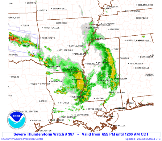
Severe Thunderstorm Watch Number 387
NWS Storm Prediction Center Norman OK
655 PM CDT Mon Jun 3 2024
The NWS Storm Prediction Center has issued a
* Severe Thunderstorm Watch for portions of
Southeast Arkansas
Northeast Louisiana
Western Mississippi
* Effective this Monday night from 655 PM until Midnight CDT.
* Primary threats include...
Scattered damaging wind gusts to 70 mph likely
Scattered large hail and isolated very large hail events to 2
inches in diameter possible
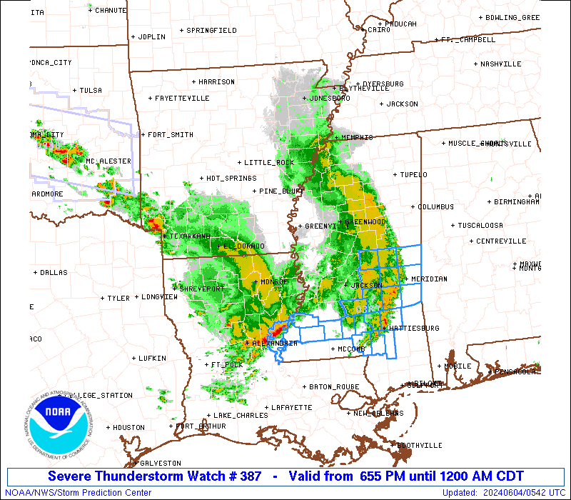
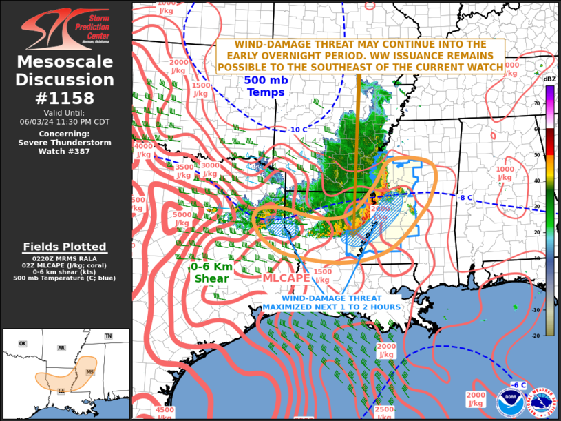
SUMMARY...A line of thunderstorms will spread eastward through the
evening, posing a risk of locally damaging wind gusts across the
watch area.
The severe thunderstorm watch area is approximately along and 40
statute miles east and west of a line from 100 miles north northeast
of Greenville MS to 25 miles west southwest of Natchez MS. For a
complete depiction of the watch see the associated watch outline
update (WOUS64 KWNS WOU7).
PRECAUTIONARY/PREPAREDNESS ACTIONS...
REMEMBER...A Severe Thunderstorm Watch means conditions are
favorable for severe thunderstorms in and close to the watch area.
Persons in these areas should be on the lookout for threatening
weather conditions and listen for later statements and possible
warnings. Severe thunderstorms can and occasionally do produce
tornadoes.
&&
OTHER WATCH INFORMATION...CONTINUE...WW 385...WW 386...
AVIATION...A few severe thunderstorms with hail surface and aloft to
2 inches. Extreme turbulence and surface wind gusts to 60 knots. A
few cumulonimbi with maximum tops to 500. Mean storm motion vector
27030.
...Hart

   SEL7

   URGENT - IMMEDIATE BROADCAST REQUESTED
   Severe Thunderstorm Watch Number 387
   NWS Storm Prediction Center Norman OK
   655 PM CDT Mon Jun 3 2024

   The NWS Storm Prediction Center has issued a

   * Severe Thunderstorm Watch for portions of
     Southeast Arkansas
     Northeast Louisiana
     Western Mississippi

   * Effective this Monday night from 655 PM until Midnight CDT.

   * Primary threats include...
     Scattered damaging wind gusts to 70 mph likely
     Scattered large hail and isolated very large hail events to 2
       inches in diameter possible

   SUMMARY...A line of thunderstorms will spread eastward through the
   evening, posing a risk of locally damaging wind gusts across the
   watch area.

   The severe thunderstorm watch area is approximately along and 40
   statute miles east and west of a line from 100 miles north northeast
   of Greenville MS to 25 miles west southwest of Natchez MS. For a
   complete depiction of the watch see the associated watch outline
   update (WOUS64 KWNS WOU7).

   PRECAUTIONARY/PREPAREDNESS ACTIONS...

   REMEMBER...A Severe Thunderstorm Watch means conditions are
   favorable for severe thunderstorms in and close to the watch area.
   Persons in these areas should be on the lookout for threatening
   weather conditions and listen for later statements and possible
   warnings. Severe thunderstorms can and occasionally do produce
   tornadoes.

   &&

   OTHER WATCH INFORMATION...CONTINUE...WW 385...WW 386...

   AVIATION...A few severe thunderstorms with hail surface and aloft to
   2 inches. Extreme turbulence and surface wind gusts to 60 knots. A
   few cumulonimbi with maximum tops to 500. Mean storm motion vector
   27030.

   ...Hart
 Note:
The Aviation Watch (SAW) product is an approximation to the watch area.
The actual watch is depicted by the shaded areas.
Note:
The Aviation Watch (SAW) product is an approximation to the watch area.
The actual watch is depicted by the shaded areas.
SAW7
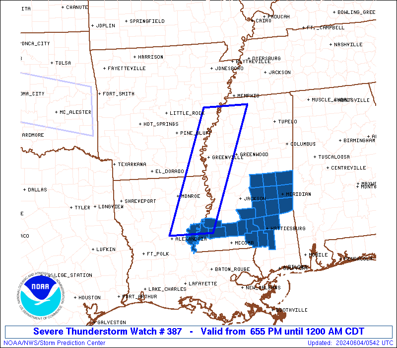
WW 387 SEVERE TSTM AR LA MS 032355Z - 040500Z
AXIS..40 STATUTE MILES EAST AND WEST OF LINE..
100NNE GLH/GREENVILLE MS/ - 25WSW HEZ/NATCHEZ MS/
..AVIATION COORDS.. 35NM E/W /22SW MEM - 43ENE AEX/
HAIL SURFACE AND ALOFT..2 INCHES. WIND GUSTS..60 KNOTS.
MAX TOPS TO 500. MEAN STORM MOTION VECTOR 27030.
LAT...LON 34808960 31489101 31489237 34809101
THIS IS AN APPROXIMATION TO THE WATCH AREA. FOR A
COMPLETE DEPICTION OF THE WATCH SEE WOUS64 KWNS
FOR WOU7.
Watch 387 Status Report Messages:
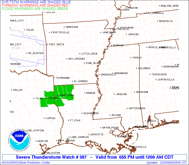
STATUS REPORT #3 ON WW 387

VALID 040450Z - 040540Z

SEVERE WEATHER THREAT CONTINUES RIGHT OF A LINE FROM 25 SW HEZ TO
45 NW PIB TO 55 NNW PIB TO 55 WNW MEI TO 30 ESE GWO TO 30 NNE GWO
TO 35 W MEM.

..BROYLES..06/04/24

ATTN...WFO...JAN...MEG...

&&

STATUS REPORT FOR WS 387

SEVERE WEATHER THREAT CONTINUES FOR THE FOLLOWING AREAS

LAC029-040540-

LA
.    LOUISIANA PARISHES INCLUDED ARE

CONCORDIA
$$


MSC001-023-031-035-037-061-063-065-067-069-073-075-077-079-085-
091-099-101-123-127-129-040540-

MS
.    MISSISSIPPI COUNTIES INCLUDED ARE

ADAMS		     CLARKE		 COVINGTON
FORREST 	     FRANKLIN		 JASPER
JEFFERSON	     JEFFERSON DAVIS	 JONES
KEMPER		     LAMAR		 LAUDERDALE
LAWRENCE	     LEAKE		 LINCOLN
MARION		     NESHOBA		 NEWTON
SCOTT		     SIMPSON		 SMITH
$$


THE WATCH STATUS MESSAGE IS FOR GUIDANCE PURPOSES ONLY.  PLEASE
REFER TO WATCH COUNTY NOTIFICATION STATEMENTS FOR OFFICIAL
INFORMATION ON COUNTIES...INDEPENDENT CITIES AND MARINE ZONES
CLEARED FROM SEVERE THUNDERSTORM AND TORNADO WATCHES.
$$

STATUS REPORT #2 ON WW 387

VALID 040240Z - 040340Z

SEVERE WEATHER THREAT CONTINUES RIGHT OF A LINE FROM 30 SSW MLU
TO 30 ESE MLU TO 40 S GLH TO 15 NNE GLH TO 45 ENE PBF.

..BROYLES..06/04/24

ATTN...WFO...JAN...MEG...

&&

STATUS REPORT FOR WS 387

SEVERE WEATHER THREAT CONTINUES FOR THE FOLLOWING AREAS

LAC025-029-041-065-107-040340-

LA
.    LOUISIANA PARISHES INCLUDED ARE

CATAHOULA	     CONCORDIA		 FRANKLIN
MADISON 	     TENSAS
$$


MSC001-015-021-029-037-043-049-051-053-055-063-083-085-089-121-
125-127-133-149-163-040340-

MS
.    MISSISSIPPI COUNTIES INCLUDED ARE

ADAMS		     CARROLL		 CLAIBORNE
COPIAH		     FRANKLIN		 GRENADA
HINDS		     HOLMES		 HUMPHREYS
ISSAQUENA	     JEFFERSON		 LEFLORE
LINCOLN 	     MADISON		 RANKIN
SHARKEY 	     SIMPSON		 SUNFLOWER
WARREN		     YAZOO
$$


THE WATCH STATUS MESSAGE IS FOR GUIDANCE PURPOSES ONLY.  PLEASE
REFER TO WATCH COUNTY NOTIFICATION STATEMENTS FOR OFFICIAL
INFORMATION ON COUNTIES...INDEPENDENT CITIES AND MARINE ZONES
CLEARED FROM SEVERE THUNDERSTORM AND TORNADO WATCHES.
$$

STATUS REPORT #1 ON WW 387

VALID 040055Z - 040140Z

THE SEVERE WEATHER THREAT CONTINUES ACROSS THE ENTIRE WATCH AREA.

..BROYLES..06/04/24

ATTN...WFO...JAN...MEG...

&&

STATUS REPORT FOR WS 387

SEVERE WEATHER THREAT CONTINUES FOR THE FOLLOWING AREAS

ARC003-017-077-107-040140-

AR
.    ARKANSAS COUNTIES INCLUDED ARE

ASHLEY		     CHICOT		 LEE
PHILLIPS
$$


LAC025-029-035-041-065-067-083-107-123-040140-

LA
.    LOUISIANA PARISHES INCLUDED ARE

CATAHOULA	     CONCORDIA		 EAST CARROLL
FRANKLIN	     MADISON		 MOREHOUSE
RICHLAND	     TENSAS		 WEST CARROLL
$$


MSC011-015-027-043-051-053-055-083-107-119-125-133-135-137-143-
149-151-161-163-040140-

MS
.    MISSISSIPPI COUNTIES INCLUDED ARE

BOLIVAR 	     CARROLL		 COAHOMA
GRENADA 	     HOLMES		 HUMPHREYS
ISSAQUENA	     LEFLORE		 PANOLA
QUITMAN 	     SHARKEY		 SUNFLOWER
TALLAHATCHIE	     TATE		 TUNICA
WARREN		     WASHINGTON 	 YALOBUSHA
YAZOO
$$


THE WATCH STATUS MESSAGE IS FOR GUIDANCE PURPOSES ONLY.  PLEASE
REFER TO WATCH COUNTY NOTIFICATION STATEMENTS FOR OFFICIAL
INFORMATION ON COUNTIES...INDEPENDENT CITIES AND MARINE ZONES
CLEARED FROM SEVERE THUNDERSTORM AND TORNADO WATCHES.
$$
Note:
Click for Complete Product Text.
Tornadoes
Probability of 2 or more tornadoes
|
Low (<5%)
|
Probability of 1 or more strong (EF2-EF5) tornadoes
|
Low (<2%)
|
Wind
Probability of 10 or more severe wind events
|
Mod (60%)
|
Probability of 1 or more wind events > 65 knots
|
Low (20%)
|
Hail
Probability of 10 or more severe hail events
|
Mod (40%)
|
Probability of 1 or more hailstones > 2 inches
|
Mod (30%)
|
Combined Severe Hail/Wind
Probability of 6 or more combined severe hail/wind events
|
High (90%)
|
For each watch, probabilities for particular events inside the watch
(listed above in each table) are determined by the issuing forecaster.
The "Low" category contains probability values ranging from less than 2%
to 20% (EF2-EF5 tornadoes), less than 5% to 20% (all other probabilities),
"Moderate" from 30% to 60%, and "High" from 70% to greater than 95%.
High values are bolded and lighter in color to provide awareness of
an increased threat for a particular event.


 @NWSSPC