Note:
The expiration time in the watch graphic is amended if the watch is
replaced, cancelled or extended.
Note:
Note:
The expiration time in the watch graphic is amended if the watch is
replaced, cancelled or extended.
Note: Click for
Watch Status Reports.
SEL1
URGENT - IMMEDIATE BROADCAST REQUESTED
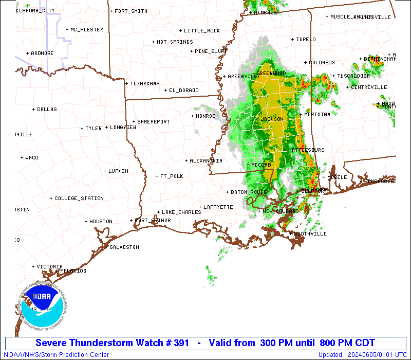
Severe Thunderstorm Watch Number 391
NWS Storm Prediction Center Norman OK
300 PM CDT Tue Jun 4 2024
The NWS Storm Prediction Center has issued a
* Severe Thunderstorm Watch for portions of
Southern Louisiana
Southern Mississippi
* Effective this Tuesday afternoon and evening from 300 PM until
800 PM CDT.
* Primary threats include...
Scattered damaging wind gusts to 65 mph possible
Isolated large hail events to 1.5 inches in diameter possible
SUMMARY...A squall line will continue to move east-southeast across
southern Louisiana and southern Mississippi through the afternoon
and into the evening into a very moist and unstable airmass. The
more intense portions of the squall line will be capable of strong
to severe gusts (55-65 mph) and potential wind damage.
The severe thunderstorm watch area is approximately along and 55
statute miles north and south of a line from 20 miles north
northwest of Lake Charles LA to 60 miles east northeast of Mc Comb
MS. For a complete depiction of the watch see the associated watch
outline update (WOUS64 KWNS WOU1).
PRECAUTIONARY/PREPAREDNESS ACTIONS...
REMEMBER...A Severe Thunderstorm Watch means conditions are
favorable for severe thunderstorms in and close to the watch area.
Persons in these areas should be on the lookout for threatening
weather conditions and listen for later statements and possible
warnings. Severe thunderstorms can and occasionally do produce
tornadoes.
&&
OTHER WATCH INFORMATION...CONTINUE...WW 389...WW 390...
AVIATION...A few severe thunderstorms with hail surface and aloft to
1.5 inches. Extreme turbulence and surface wind gusts to 55 knots. A
few cumulonimbi with maximum tops to 500. Mean storm motion vector
29035.
...Smith
 Note:
The Aviation Watch (SAW) product is an approximation to the watch area.
The actual watch is depicted by the shaded areas.
Note:
The Aviation Watch (SAW) product is an approximation to the watch area.
The actual watch is depicted by the shaded areas.
   SAW1
   WW 391 SEVERE TSTM LA MS 042000Z - 050100Z
   AXIS..55 STATUTE MILES NORTH AND SOUTH OF LINE..
   20NNW LCH/LAKE CHARLES LA/ - 60ENE MCB/MC COMB MS/
   ..AVIATION COORDS.. 50NM N/S /20NW LCH - 40ENE MCB/
   HAIL SURFACE AND ALOFT..1.5 INCHES. WIND GUSTS..55 KNOTS.
   MAX TOPS TO 500. MEAN STORM MOTION VECTOR 29035.

   LAT...LON 31199335 32308953 30718953 29609335

   THIS IS AN APPROXIMATION TO THE WATCH AREA.  FOR A
   COMPLETE DEPICTION OF THE WATCH SEE WOUS64 KWNS
   FOR WOU1.
Watch 391 Status Report Messages:
STATUS REPORT #4 ON WW 391
VALID 042345Z - 050040Z
SEVERE WEATHER THREAT CONTINUES RIGHT OF A LINE FROM 15 WSW MSY
TO 20 NW ASD TO 30 SW PIB TO 25 WNW PIB TO 60 W MEI TO 40 S GWO.
..THORNTON..06/04/24
ATTN...WFO...LCH...LIX...JAN...
&&
STATUS REPORT FOR WS 391
SEVERE WEATHER THREAT CONTINUES FOR THE FOLLOWING AREAS
LAC103-050040-
LA
. LOUISIANA PARISHES INCLUDED ARE
ST. TAMMANY
$$
MSC023-031-035-061-067-073-075-101-109-123-129-050040-
MS
. MISSISSIPPI COUNTIES INCLUDED ARE
CLARKE COVINGTON FORREST
JASPER JONES LAMAR
LAUDERDALE NEWTON PEARL RIVER
SCOTT SMITH
$$
GMZ530-050040-
CW
. ADJACENT COASTAL WATERS INCLUDED ARE
GMZ530
$$
THE WATCH STATUS MESSAGE IS FOR GUIDANCE PURPOSES ONLY. PLEASE
REFER TO WATCH COUNTY NOTIFICATION STATEMENTS FOR OFFICIAL
INFORMATION ON COUNTIES...INDEPENDENT CITIES AND MARINE ZONES
CLEARED FROM SEVERE THUNDERSTORM AND TORNADO WATCHES.
$$
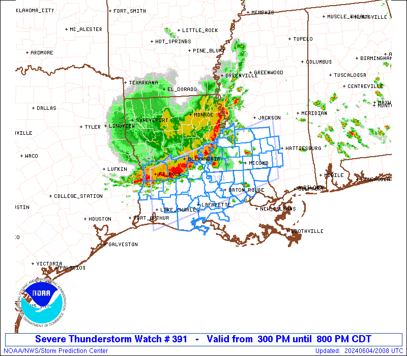
STATUS REPORT #3 ON WW 391
VALID 042255Z - 042340Z
SEVERE WEATHER THREAT CONTINUES RIGHT OF A LINE FROM 20 WSW LCH
TO 35 ENE LFT TO 50 NW MSY TO 25 NNE MCB TO 40 SSE GWO.
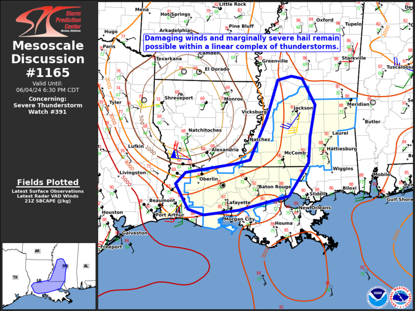
FOR ADDITIONAL INFORMATION SEE MESOSCALE DISCUSSION 1165
..THORNTON..06/04/24
ATTN...WFO...LCH...LIX...JAN...
&&
STATUS REPORT FOR WS 391
SEVERE WEATHER THREAT CONTINUES FOR THE FOLLOWING AREAS
LAC001-005-045-047-055-063-099-103-105-113-117-042340-
LA
. LOUISIANA PARISHES INCLUDED ARE
ACADIA ASCENSION IBERIA
IBERVILLE LAFAYETTE LIVINGSTON
ST. MARTIN ST. TAMMANY TANGIPAHOA
VERMILION WASHINGTON
$$
MSC023-031-035-061-065-067-073-075-077-091-101-109-113-121-123-
127-129-147-042340-
MS
. MISSISSIPPI COUNTIES INCLUDED ARE
CLARKE COVINGTON FORREST
JASPER JEFFERSON DAVIS JONES
LAMAR LAUDERDALE LAWRENCE
MARION NEWTON PEARL RIVER
PIKE RANKIN SCOTT
SIMPSON SMITH WALTHALL
$$
GMZ530-042340-
CW
. ADJACENT COASTAL WATERS INCLUDED ARE
GMZ530
$$
THE WATCH STATUS MESSAGE IS FOR GUIDANCE PURPOSES ONLY. PLEASE
REFER TO WATCH COUNTY NOTIFICATION STATEMENTS FOR OFFICIAL
INFORMATION ON COUNTIES...INDEPENDENT CITIES AND MARINE ZONES
CLEARED FROM SEVERE THUNDERSTORM AND TORNADO WATCHES.
$$
STATUS REPORT #2 ON WW 391
VALID 042140Z - 042240Z
SEVERE WEATHER THREAT CONTINUES RIGHT OF A LINE FROM 35 NNW LCH
TO 35 ESE POE TO 35 NNW LFT TO 40 S HEZ TO 10 E HEZ TO 20 E HEZ
TO 60 NNE HEZ.
..THORNTON..06/04/24
ATTN...WFO...LCH...LIX...JAN...
&&
STATUS REPORT FOR WS 391
SEVERE WEATHER THREAT CONTINUES FOR THE FOLLOWING AREAS
LAC001-003-005-033-037-045-047-053-055-063-077-091-097-099-105-
113-117-121-125-042240-
LA
. LOUISIANA PARISHES INCLUDED ARE
ACADIA ALLEN ASCENSION
EAST BATON ROUGE EAST FELICIANA IBERIA
IBERVILLE JEFFERSON DAVIS LAFAYETTE
LIVINGSTON POINTE COUPEE ST. HELENA
ST. LANDRY ST. MARTIN TANGIPAHOA
VERMILION WASHINGTON WEST BATON ROUGE
WEST FELICIANA
$$
MSC005-023-029-031-035-037-049-061-065-067-073-075-077-085-089-
091-101-113-121-123-127-129-147-157-042240-
MS
. MISSISSIPPI COUNTIES INCLUDED ARE
AMITE CLARKE COPIAH
COVINGTON FORREST FRANKLIN
HINDS JASPER JEFFERSON DAVIS
JONES LAMAR LAUDERDALE
LAWRENCE LINCOLN MADISON
MARION NEWTON PIKE
RANKIN SCOTT SIMPSON
SMITH WALTHALL WILKINSON
$$
THE WATCH STATUS MESSAGE IS FOR GUIDANCE PURPOSES ONLY. PLEASE
REFER TO WATCH COUNTY NOTIFICATION STATEMENTS FOR OFFICIAL
INFORMATION ON COUNTIES...INDEPENDENT CITIES AND MARINE ZONES
CLEARED FROM SEVERE THUNDERSTORM AND TORNADO WATCHES.
$$
STATUS REPORT #1 ON WW 391
VALID 042120Z - 042240Z
SEVERE WEATHER THREAT CONTINUES RIGHT OF A LINE FROM 25 WSW POE
TO 20 SE POE TO 35 ESE POE TO 30 S ESF TO 40 SE ESF TO 25 SW HEZ
TO 30 N HEZ.
..LYONS..06/04/24
ATTN...WFO...LCH...LIX...JAN...
&&
STATUS REPORT FOR WS 391
SEVERE WEATHER THREAT CONTINUES FOR THE FOLLOWING AREAS
LAC001-003-005-011-033-037-039-045-047-053-055-063-077-091-097-
099-105-113-117-121-125-042240-
LA
. LOUISIANA PARISHES INCLUDED ARE
ACADIA ALLEN ASCENSION
BEAUREGARD EAST BATON ROUGE EAST FELICIANA
EVANGELINE IBERIA IBERVILLE
JEFFERSON DAVIS LAFAYETTE LIVINGSTON
POINTE COUPEE ST. HELENA ST. LANDRY
ST. MARTIN TANGIPAHOA VERMILION
WASHINGTON WEST BATON ROUGE WEST FELICIANA
$$
MSC001-005-021-023-029-031-035-037-049-061-063-065-067-073-075-
077-085-089-091-101-113-121-123-127-129-147-157-042240-
MS
. MISSISSIPPI COUNTIES INCLUDED ARE
ADAMS AMITE CLAIBORNE
CLARKE COPIAH COVINGTON
FORREST FRANKLIN HINDS
JASPER JEFFERSON JEFFERSON DAVIS
JONES LAMAR LAUDERDALE
LAWRENCE LINCOLN MADISON
MARION NEWTON PIKE
RANKIN SCOTT SIMPSON
SMITH WALTHALL WILKINSON
$$
THE WATCH STATUS MESSAGE IS FOR GUIDANCE PURPOSES ONLY. PLEASE
REFER TO WATCH COUNTY NOTIFICATION STATEMENTS FOR OFFICIAL
INFORMATION ON COUNTIES...INDEPENDENT CITIES AND MARINE ZONES
CLEARED FROM SEVERE THUNDERSTORM AND TORNADO WATCHES.
$$
Note:
Click for Complete Product Text.
Tornadoes
Probability of 2 or more tornadoes
|
Low (<5%)
|
Probability of 1 or more strong (EF2-EF5) tornadoes
|
Low (<2%)
|
Wind
Probability of 10 or more severe wind events
|
Mod (40%)
|
Probability of 1 or more wind events > 65 knots
|
Low (20%)
|
Hail
Probability of 10 or more severe hail events
|
Low (20%)
|
Probability of 1 or more hailstones > 2 inches
|
Low (<5%)
|
Combined Severe Hail/Wind
Probability of 6 or more combined severe hail/wind events
|
Mod (60%)
|
For each watch, probabilities for particular events inside the watch
(listed above in each table) are determined by the issuing forecaster.
The "Low" category contains probability values ranging from less than 2%
to 20% (EF2-EF5 tornadoes), less than 5% to 20% (all other probabilities),
"Moderate" from 30% to 60%, and "High" from 70% to greater than 95%.
High values are bolded and lighter in color to provide awareness of
an increased threat for a particular event.


 @NWSSPC