Note:
The expiration time in the watch graphic is amended if the watch is
replaced, cancelled or extended.
Note:
Note:
The expiration time in the watch graphic is amended if the watch is
replaced, cancelled or extended.
Note: Click for
Watch Status Reports.
SEL2
URGENT - IMMEDIATE BROADCAST REQUESTED
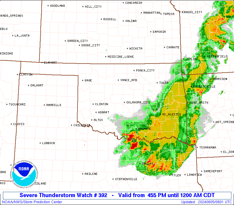
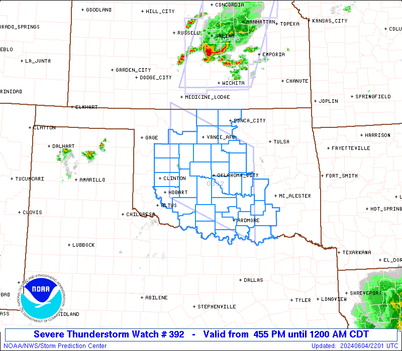
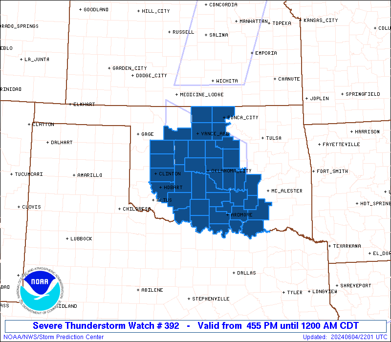
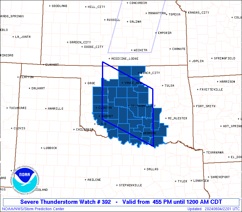
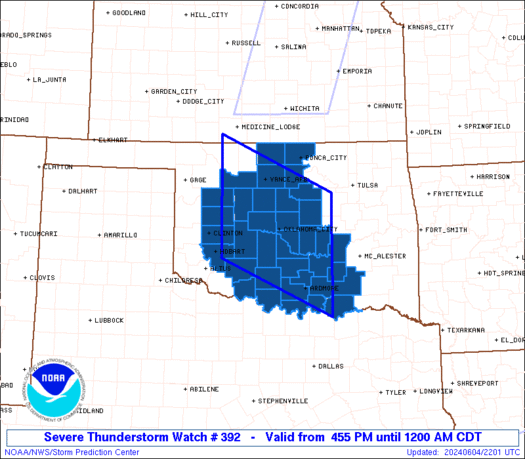
Severe Thunderstorm Watch Number 392
NWS Storm Prediction Center Norman OK
455 PM CDT Tue Jun 4 2024
The NWS Storm Prediction Center has issued a
* Severe Thunderstorm Watch for portions of
Western and Central Oklahoma
* Effective this Tuesday afternoon from 455 PM until Midnight
CDT.
* Primary threats include...
Scattered damaging winds and isolated significant gusts to 75
mph likely
Scattered large hail and isolated very large hail events to 2.5
inches in diameter likely
A tornado or two possible
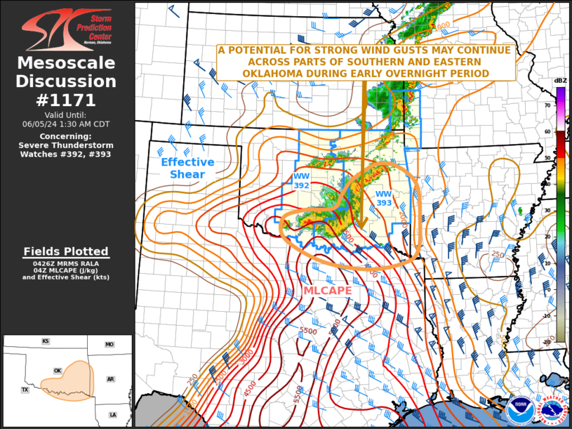
SUMMARY...Thunderstorms are expected to rapidly intensify late this
afternoon across west central Oklahoma and track east-southeastward
across the watch area. Supercell storms capable of very large hail
and damaging winds are the main concern. An isolated tornado or two
is also possible with the strongest cells.
The severe thunderstorm watch area is approximately along and 80
statute miles north and south of a line from 60 miles west southwest
of Enid OK to 60 miles south southeast of Chandler OK. For a
complete depiction of the watch see the associated watch outline
update (WOUS64 KWNS WOU2).
PRECAUTIONARY/PREPAREDNESS ACTIONS...
REMEMBER...A Severe Thunderstorm Watch means conditions are
favorable for severe thunderstorms in and close to the watch area.
Persons in these areas should be on the lookout for threatening
weather conditions and listen for later statements and possible
warnings. Severe thunderstorms can and occasionally do produce
tornadoes.
&&
OTHER WATCH INFORMATION...CONTINUE...WW 389...WW 390...WW 391...
AVIATION...A few severe thunderstorms with hail surface and aloft to
2.5 inches. Extreme turbulence and surface wind gusts to 65 knots. A
few cumulonimbi with maximum tops to 500. Mean storm motion vector
29025.
...Hart
 Note:
The Aviation Watch (SAW) product is an approximation to the watch area.
The actual watch is depicted by the shaded areas.
Note:
The Aviation Watch (SAW) product is an approximation to the watch area.
The actual watch is depicted by the shaded areas.
   SAW2
   WW 392 SEVERE TSTM OK 042155Z - 050500Z
   AXIS..80 STATUTE MILES NORTH AND SOUTH OF LINE..
   60WSW END/ENID OK/ - 60SSE CQB/CHANDLER OK/
   ..AVIATION COORDS.. 70NM N/S /51ESE MMB - 32W MLC/
   HAIL SURFACE AND ALOFT..2.5 INCHES. WIND GUSTS..65 KNOTS.
   MAX TOPS TO 500. MEAN STORM MOTION VECTOR 29025.

   LAT...LON 37169891 36079641 33759641 34869891

   THIS IS AN APPROXIMATION TO THE WATCH AREA.  FOR A
   COMPLETE DEPICTION OF THE WATCH SEE WOUS64 KWNS
   FOR WOU2.
Watch 392 Status Report Messages:
STATUS REPORT #5 ON WW 392

VALID 050425Z - 050540Z

SEVERE WEATHER THREAT CONTINUES RIGHT OF A LINE FROM 20 WSW FSI
TO 25 NNW ADM TO 20 E OKC TO 20 SSE END TO 20 SSE PNC.

..HART..06/05/24

ATTN...WFO...OUN...

&&

STATUS REPORT FOR WS 392

SEVERE WEATHER THREAT CONTINUES FOR THE FOLLOWING AREAS

OKC031-033-049-067-081-083-103-109-119-125-133-137-050540-

OK
.    OKLAHOMA COUNTIES INCLUDED ARE

COMANCHE	     COTTON		 GARVIN
JEFFERSON	     LINCOLN		 LOGAN
NOBLE		     OKLAHOMA		 PAYNE
POTTAWATOMIE	     SEMINOLE		 STEPHENS
$$


THE WATCH STATUS MESSAGE IS FOR GUIDANCE PURPOSES ONLY.  PLEASE
REFER TO WATCH COUNTY NOTIFICATION STATEMENTS FOR OFFICIAL
INFORMATION ON COUNTIES...INDEPENDENT CITIES AND MARINE ZONES
CLEARED FROM SEVERE THUNDERSTORM AND TORNADO WATCHES.
$$

STATUS REPORT #4 ON WW 392

VALID 050330Z - 050440Z

SEVERE WEATHER THREAT CONTINUES RIGHT OF A LINE FROM 10 NE LTS TO
15 WSW CHK TO 30 NNW CHK TO 40 SW AVK.

..BROYLES..06/05/24

ATTN...WFO...OUN...

&&

STATUS REPORT FOR WS 392

SEVERE WEATHER THREAT CONTINUES FOR THE FOLLOWING AREAS

OKC011-017-027-031-033-047-049-051-053-067-071-073-081-083-087-
093-103-109-119-125-133-137-050440-

OK
.    OKLAHOMA COUNTIES INCLUDED ARE

BLAINE		     CANADIAN		 CLEVELAND
COMANCHE	     COTTON		 GARFIELD
GARVIN		     GRADY		 GRANT
JEFFERSON	     KAY		 KINGFISHER
LINCOLN 	     LOGAN		 MCCLAIN
MAJOR		     NOBLE		 OKLAHOMA
PAYNE		     POTTAWATOMIE	 SEMINOLE
STEPHENS
$$


THE WATCH STATUS MESSAGE IS FOR GUIDANCE PURPOSES ONLY.  PLEASE
REFER TO WATCH COUNTY NOTIFICATION STATEMENTS FOR OFFICIAL
INFORMATION ON COUNTIES...INDEPENDENT CITIES AND MARINE ZONES
CLEARED FROM SEVERE THUNDERSTORM AND TORNADO WATCHES.
$$

STATUS REPORT #3 ON WW 392

VALID 050135Z - 050240Z

THE SEVERE WEATHER THREAT CONTINUES ACROSS THE ENTIRE WATCH AREA.

..BROYLES..06/05/24

ATTN...WFO...OUN...

&&

STATUS REPORT FOR WS 392

SEVERE WEATHER THREAT CONTINUES FOR THE FOLLOWING AREAS

OKC005-011-013-015-017-019-027-029-031-033-039-043-047-049-051-
053-063-067-069-071-073-075-081-083-085-087-093-095-099-103-109-
119-123-125-133-137-149-050240-

OK
.    OKLAHOMA COUNTIES INCLUDED ARE

ATOKA		     BLAINE		 BRYAN
CADDO		     CANADIAN		 CARTER
CLEVELAND	     COAL		 COMANCHE
COTTON		     CUSTER		 DEWEY
GARFIELD	     GARVIN		 GRADY
GRANT		     HUGHES		 JEFFERSON
JOHNSTON	     KAY		 KINGFISHER
KIOWA		     LINCOLN		 LOGAN
LOVE		     MCCLAIN		 MAJOR
MARSHALL	     MURRAY		 NOBLE
OKLAHOMA	     PAYNE		 PONTOTOC
POTTAWATOMIE	     SEMINOLE		 STEPHENS
WASHITA
$$


THE WATCH STATUS MESSAGE IS FOR GUIDANCE PURPOSES ONLY.  PLEASE
REFER TO WATCH COUNTY NOTIFICATION STATEMENTS FOR OFFICIAL
INFORMATION ON COUNTIES...INDEPENDENT CITIES AND MARINE ZONES
CLEARED FROM SEVERE THUNDERSTORM AND TORNADO WATCHES.
$$

STATUS REPORT #2 ON WW 392

VALID 042340Z - 050040Z

THE SEVERE WEATHER THREAT CONTINUES ACROSS THE ENTIRE WATCH AREA.

..THORNTON..06/04/24

ATTN...WFO...OUN...

&&

STATUS REPORT FOR WS 392

SEVERE WEATHER THREAT CONTINUES FOR THE FOLLOWING AREAS

OKC005-011-013-015-017-019-027-029-031-033-039-043-047-049-051-
053-063-067-069-071-073-075-081-083-085-087-093-095-099-103-109-
119-123-125-133-137-149-050040-

OK
.    OKLAHOMA COUNTIES INCLUDED ARE

ATOKA		     BLAINE		 BRYAN
CADDO		     CANADIAN		 CARTER
CLEVELAND	     COAL		 COMANCHE
COTTON		     CUSTER		 DEWEY
GARFIELD	     GARVIN		 GRADY
GRANT		     HUGHES		 JEFFERSON
JOHNSTON	     KAY		 KINGFISHER
KIOWA		     LINCOLN		 LOGAN
LOVE		     MCCLAIN		 MAJOR
MARSHALL	     MURRAY		 NOBLE
OKLAHOMA	     PAYNE		 PONTOTOC
POTTAWATOMIE	     SEMINOLE		 STEPHENS
WASHITA
$$


THE WATCH STATUS MESSAGE IS FOR GUIDANCE PURPOSES ONLY.  PLEASE
REFER TO WATCH COUNTY NOTIFICATION STATEMENTS FOR OFFICIAL
INFORMATION ON COUNTIES...INDEPENDENT CITIES AND MARINE ZONES
CLEARED FROM SEVERE THUNDERSTORM AND TORNADO WATCHES.
$$

STATUS REPORT #1 ON WW 392

VALID 042245Z - 042340Z

THE SEVERE WEATHER THREAT CONTINUES ACROSS THE ENTIRE WATCH AREA.

..THORNTON..06/04/24

ATTN...WFO...OUN...

&&

STATUS REPORT FOR WS 392

SEVERE WEATHER THREAT CONTINUES FOR THE FOLLOWING AREAS

OKC005-011-013-015-017-019-027-029-031-033-039-043-047-049-051-
053-063-067-069-071-073-075-081-083-085-087-093-095-099-103-109-
119-123-125-133-137-149-042340-

OK
.    OKLAHOMA COUNTIES INCLUDED ARE

ATOKA		     BLAINE		 BRYAN
CADDO		     CANADIAN		 CARTER
CLEVELAND	     COAL		 COMANCHE
COTTON		     CUSTER		 DEWEY
GARFIELD	     GARVIN		 GRADY
GRANT		     HUGHES		 JEFFERSON
JOHNSTON	     KAY		 KINGFISHER
KIOWA		     LINCOLN		 LOGAN
LOVE		     MCCLAIN		 MAJOR
MARSHALL	     MURRAY		 NOBLE
OKLAHOMA	     PAYNE		 PONTOTOC
POTTAWATOMIE	     SEMINOLE		 STEPHENS
WASHITA
$$


THE WATCH STATUS MESSAGE IS FOR GUIDANCE PURPOSES ONLY.  PLEASE
REFER TO WATCH COUNTY NOTIFICATION STATEMENTS FOR OFFICIAL
INFORMATION ON COUNTIES...INDEPENDENT CITIES AND MARINE ZONES
CLEARED FROM SEVERE THUNDERSTORM AND TORNADO WATCHES.
$$
Note:
Click for Complete Product Text.
Tornadoes
Probability of 2 or more tornadoes
|
Low (20%)
|
Probability of 1 or more strong (EF2-EF5) tornadoes
|
Low (5%)
|
Wind
Probability of 10 or more severe wind events
|
High (70%)
|
Probability of 1 or more wind events > 65 knots
|
Mod (60%)
|
Hail
Probability of 10 or more severe hail events
|
High (70%)
|
Probability of 1 or more hailstones > 2 inches
|
Mod (60%)
|
Combined Severe Hail/Wind
Probability of 6 or more combined severe hail/wind events
|
High (>95%)
|
For each watch, probabilities for particular events inside the watch
(listed above in each table) are determined by the issuing forecaster.
The "Low" category contains probability values ranging from less than 2%
to 20% (EF2-EF5 tornadoes), less than 5% to 20% (all other probabilities),
"Moderate" from 30% to 60%, and "High" from 70% to greater than 95%.
High values are bolded and lighter in color to provide awareness of
an increased threat for a particular event.


 @NWSSPC