Note:
The expiration time in the watch graphic is amended if the watch is
replaced, cancelled or extended.
Note:
Note:
The expiration time in the watch graphic is amended if the watch is
replaced, cancelled or extended.
Note: Click for
Watch Status Reports.
SEL5
URGENT - IMMEDIATE BROADCAST REQUESTED
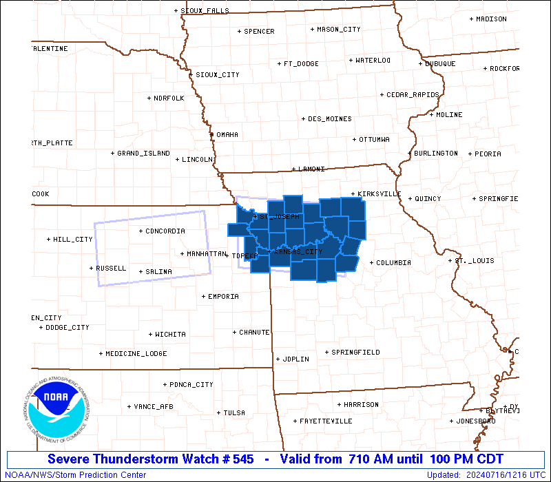
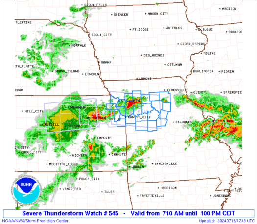
Severe Thunderstorm Watch Number 545
NWS Storm Prediction Center Norman OK
710 AM CDT Tue Jul 16 2024
The NWS Storm Prediction Center has issued a
* Severe Thunderstorm Watch for portions of
Extreme northeastern Kansas
Northwestern and north-central Missouri
* Effective this Tuesday morning and afternoon from 710 AM until
100 PM CDT.
* Primary threats include...
Scattered damaging winds and isolated significant gusts to 75
mph possible
Isolated very large hail events to 2 inches in diameter possible
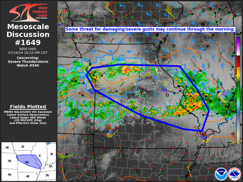
SUMMARY...Clusters of strong-severe thunderstorms are expected to
move across the watch area through the remainder of the morning and
into midday, with severe gusts and isolated large hail as the
threats.
The severe thunderstorm watch area is approximately along and 45
statute miles north and south of a line from 25 miles west northwest
of Leavenworth KS to 55 miles southeast of Chillicothe MO. For a
complete depiction of the watch see the associated watch outline
update (WOUS64 KWNS WOU5).
PRECAUTIONARY/PREPAREDNESS ACTIONS...
REMEMBER...A Severe Thunderstorm Watch means conditions are
favorable for severe thunderstorms in and close to the watch area.
Persons in these areas should be on the lookout for threatening
weather conditions and listen for later statements and possible
warnings. Severe thunderstorms can and occasionally do produce
tornadoes.
&&
OTHER WATCH INFORMATION...CONTINUE...WW 544...
AVIATION...A few severe thunderstorms with hail surface and aloft to
2 inches. Extreme turbulence and surface wind gusts to 65 knots. A
few cumulonimbi with maximum tops to 550. Mean storm motion vector
27035.
...Edwards
   SEL5

   URGENT - IMMEDIATE BROADCAST REQUESTED
   Severe Thunderstorm Watch Number 545
   NWS Storm Prediction Center Norman OK
   710 AM CDT Tue Jul 16 2024

   The NWS Storm Prediction Center has issued a

   * Severe Thunderstorm Watch for portions of
     Extreme northeastern Kansas
     Northwestern and north-central Missouri

   * Effective this Tuesday morning and afternoon from 710 AM until
     100 PM CDT.

   * Primary threats include...
     Scattered damaging winds and isolated significant gusts to 75
       mph possible
     Isolated very large hail events to 2 inches in diameter possible

   SUMMARY...Clusters of strong-severe thunderstorms are expected to
   move across the watch area through the remainder of the morning and
   into midday, with severe gusts and isolated large hail as the
   threats.

   The severe thunderstorm watch area is approximately along and 45
   statute miles north and south of a line from 25 miles west northwest
   of Leavenworth KS to 55 miles southeast of Chillicothe MO. For a
   complete depiction of the watch see the associated watch outline
   update (WOUS64 KWNS WOU5).

   PRECAUTIONARY/PREPAREDNESS ACTIONS...

   REMEMBER...A Severe Thunderstorm Watch means conditions are
   favorable for severe thunderstorms in and close to the watch area.
   Persons in these areas should be on the lookout for threatening
   weather conditions and listen for later statements and possible
   warnings. Severe thunderstorms can and occasionally do produce
   tornadoes.

   &&

   OTHER WATCH INFORMATION...CONTINUE...WW 544...

   AVIATION...A few severe thunderstorms with hail surface and aloft to
   2 inches. Extreme turbulence and surface wind gusts to 65 knots. A
   few cumulonimbi with maximum tops to 550. Mean storm motion vector
   27035.

   ...Edwards
 Note:
The Aviation Watch (SAW) product is an approximation to the watch area.
The actual watch is depicted by the shaded areas.
Note:
The Aviation Watch (SAW) product is an approximation to the watch area.
The actual watch is depicted by the shaded areas.
   SAW5
   WW 545 SEVERE TSTM KS MO 161210Z - 161800Z
   AXIS..45 STATUTE MILES NORTH AND SOUTH OF LINE..
   25WNW FLV/LEAVENWORTH KS/ - 55SE CDJ/CHILLICOTHE MO/
   ..AVIATION COORDS.. 40NM N/S /31WNW MCI - 39NW COU/
   HAIL SURFACE AND ALOFT..2 INCHES. WIND GUSTS..65 KNOTS.
   MAX TOPS TO 550. MEAN STORM MOTION VECTOR 27035.

   LAT...LON 40159535 39919285 38599285 38849535

   THIS IS AN APPROXIMATION TO THE WATCH AREA.  FOR A
   COMPLETE DEPICTION OF THE WATCH SEE WOUS64 KWNS
   FOR WOU5.
Watch 545 Status Report Messages:
STATUS REPORT #2 ON WW 545

VALID 161605Z - 161740Z

SEVERE WEATHER THREAT CONTINUES RIGHT OF A LINE FROM 15 SSW SZL
TO 35 NNE SZL TO 30 NNW COU.

..DEAN..07/16/24

ATTN...WFO...EAX...

&&

STATUS REPORT FOR WS 545

SEVERE WEATHER THREAT CONTINUES FOR THE FOLLOWING AREAS

MOC053-089-159-195-161740-

MO
.    MISSOURI COUNTIES INCLUDED ARE

COOPER		     HOWARD		 PETTIS
SALINE
$$


THE WATCH STATUS MESSAGE IS FOR GUIDANCE PURPOSES ONLY.  PLEASE
REFER TO WATCH COUNTY NOTIFICATION STATEMENTS FOR OFFICIAL
INFORMATION ON COUNTIES...INDEPENDENT CITIES AND MARINE ZONES
CLEARED FROM SEVERE THUNDERSTORM AND TORNADO WATCHES.
$$

STATUS REPORT #1 ON WW 545

VALID 161455Z - 161540Z

SEVERE WEATHER THREAT CONTINUES RIGHT OF A LINE FROM 30 WSW SZL
TO 35 SW LWD.

..HALBERT..07/16/24

ATTN...WFO...EAX...

&&

STATUS REPORT FOR WS 545

SEVERE WEATHER THREAT CONTINUES FOR THE FOLLOWING AREAS

MOC025-033-041-053-061-089-101-107-115-117-121-159-175-177-195-
161540-

MO
.    MISSOURI COUNTIES INCLUDED ARE

CALDWELL	     CARROLL		 CHARITON
COOPER		     DAVIESS		 HOWARD
JOHNSON 	     LAFAYETTE		 LINN
LIVINGSTON	     MACON		 PETTIS
RANDOLPH	     RAY		 SALINE
$$


THE WATCH STATUS MESSAGE IS FOR GUIDANCE PURPOSES ONLY.  PLEASE
REFER TO WATCH COUNTY NOTIFICATION STATEMENTS FOR OFFICIAL
INFORMATION ON COUNTIES...INDEPENDENT CITIES AND MARINE ZONES
CLEARED FROM SEVERE THUNDERSTORM AND TORNADO WATCHES.
$$
Note:
Click for Complete Product Text.
Tornadoes
Probability of 2 or more tornadoes
|
Low (<5%)
|
Probability of 1 or more strong (EF2-EF5) tornadoes
|
Low (<2%)
|
Wind
Probability of 10 or more severe wind events
|
Mod (40%)
|
Probability of 1 or more wind events > 65 knots
|
Mod (30%)
|
Hail
Probability of 10 or more severe hail events
|
Mod (30%)
|
Probability of 1 or more hailstones > 2 inches
|
Mod (30%)
|
Combined Severe Hail/Wind
Probability of 6 or more combined severe hail/wind events
|
High (70%)
|
For each watch, probabilities for particular events inside the watch
(listed above in each table) are determined by the issuing forecaster.
The "Low" category contains probability values ranging from less than 2%
to 20% (EF2-EF5 tornadoes), less than 5% to 20% (all other probabilities),
"Moderate" from 30% to 60%, and "High" from 70% to greater than 95%.
High values are bolded and lighter in color to provide awareness of
an increased threat for a particular event.


 @NWSSPC