Note:
The expiration time in the watch graphic is amended if the watch is
replaced, cancelled or extended.
Note:
Note:
The expiration time in the watch graphic is amended if the watch is
replaced, cancelled or extended.
Note: Click for
Watch Status Reports.
SEL2
URGENT - IMMEDIATE BROADCAST REQUESTED
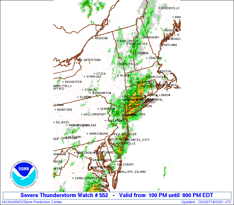
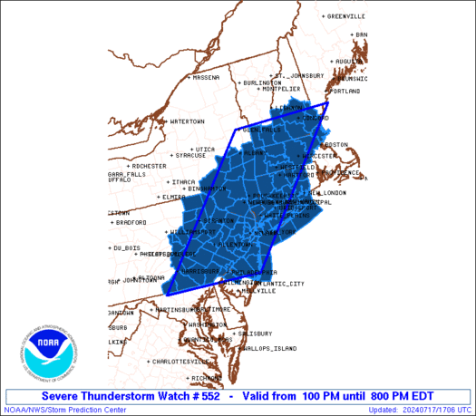
Severe Thunderstorm Watch Number 552
NWS Storm Prediction Center Norman OK
100 PM EDT Wed Jul 17 2024
The NWS Storm Prediction Center has issued a
* Severe Thunderstorm Watch for portions of
Connecticut
Massachusetts
Southern New Hampshire
Northern and Central New Jersey
Southeast New York
Eastern Pennsylvania
Southern Vermont
Coastal Waters
* Effective this Wednesday afternoon and evening from 100 PM
until 800 PM EDT.
* Primary threats include...
Scattered damaging wind gusts to 70 mph likely
Isolated large hail events to 1 inch in diameter possible
SUMMARY...Strong to severe thunderstorms will intensify through the
afternoon, with the strongest storms posing a risk of damaging wind
gusts and some hail.
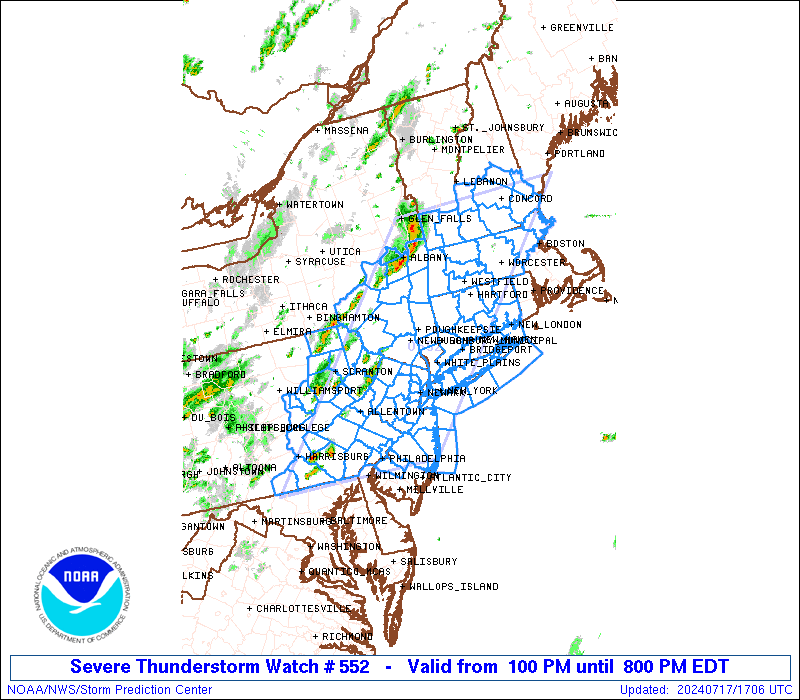
The severe thunderstorm watch area is approximately along and 85
statute miles east and west of a line from 10 miles west of
Wilmington DE to 30 miles west northwest of Concord NH. For a
complete depiction of the watch see the associated watch outline
update (WOUS64 KWNS WOU2).
PRECAUTIONARY/PREPAREDNESS ACTIONS...
REMEMBER...A Severe Thunderstorm Watch means conditions are
favorable for severe thunderstorms in and close to the watch area.
Persons in these areas should be on the lookout for threatening
weather conditions and listen for later statements and possible
warnings. Severe thunderstorms can and occasionally do produce
tornadoes.
&&
AVIATION...A few severe thunderstorms with hail surface and aloft to
1 inch. Extreme turbulence and surface wind gusts to 60 knots. A few
cumulonimbi with maximum tops to 500. Mean storm motion vector
27030.
...Hart

   SEL2

   URGENT - IMMEDIATE BROADCAST REQUESTED
   Severe Thunderstorm Watch Number 552
   NWS Storm Prediction Center Norman OK
   100 PM EDT Wed Jul 17 2024

   The NWS Storm Prediction Center has issued a

   * Severe Thunderstorm Watch for portions of
     Connecticut
     Massachusetts
     Southern New Hampshire
     Northern and Central New Jersey
     Southeast New York
     Eastern Pennsylvania
     Southern Vermont
     Coastal Waters

   * Effective this Wednesday afternoon and evening from 100 PM
     until 800 PM EDT.

   * Primary threats include...
     Scattered damaging wind gusts to 70 mph likely
     Isolated large hail events to 1 inch in diameter possible

   SUMMARY...Strong to severe thunderstorms will intensify through the
   afternoon, with the strongest storms posing a risk of damaging wind
   gusts and some hail.

   The severe thunderstorm watch area is approximately along and 85
   statute miles east and west of a line from 10 miles west of
   Wilmington DE to 30 miles west northwest of Concord NH. For a
   complete depiction of the watch see the associated watch outline
   update (WOUS64 KWNS WOU2).

   PRECAUTIONARY/PREPAREDNESS ACTIONS...

   REMEMBER...A Severe Thunderstorm Watch means conditions are
   favorable for severe thunderstorms in and close to the watch area.
   Persons in these areas should be on the lookout for threatening
   weather conditions and listen for later statements and possible
   warnings. Severe thunderstorms can and occasionally do produce
   tornadoes.

   &&

   AVIATION...A few severe thunderstorms with hail surface and aloft to
   1 inch. Extreme turbulence and surface wind gusts to 60 knots. A few
   cumulonimbi with maximum tops to 500. Mean storm motion vector
   27030.

   ...Hart
 Note:
The Aviation Watch (SAW) product is an approximation to the watch area.
The actual watch is depicted by the shaded areas.
Note:
The Aviation Watch (SAW) product is an approximation to the watch area.
The actual watch is depicted by the shaded areas.
   SAW2
   WW 552 SEVERE TSTM CT MA NH NJ NY PA VT CW 171700Z - 180000Z
   AXIS..85 STATUTE MILES EAST AND WEST OF LINE..
   10W ILG/WILMINGTON DE/ - 30WNW CON/CONCORD NH/
   ..AVIATION COORDS.. 75NM E/W /54S ETX - 22WNW CON/
   HAIL SURFACE AND ALOFT..1 INCH. WIND GUSTS..60 KNOTS.
   MAX TOPS TO 500. MEAN STORM MOTION VECTOR 27030.

   LAT...LON 39667737 43357374 43357036 39667418

   THIS IS AN APPROXIMATION TO THE WATCH AREA.  FOR A
   COMPLETE DEPICTION OF THE WATCH SEE WOUS64 KWNS
   FOR WOU2.
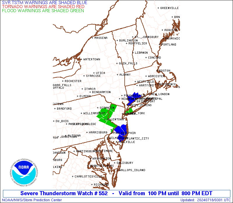
Watch 552 Status Report Messages:
STATUS REPORT #3 ON WW 552
VALID 172325Z - 180040Z
SEVERE WEATHER THREAT CONTINUES RIGHT OF A LINE FROM 35 NNW BWI
TO 30 E CXY TO 15 NW ABE TO 30 ESE AVP TO 30 SSW MSV TO 20 E MSV
TO 30 NNE POU TO 5 WSW BAF TO 15 WSW ORH TO 30 E LCI.
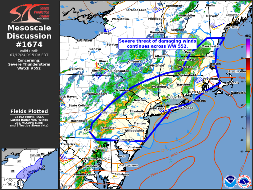
FOR ADDITIONAL INFORMATION SEE MESOSCALE DISCUSSION 1674
..GLEASON..07/17/24
ATTN...WFO...OKX...BOX...ALY...GYX...PHI...BGM...CTP...
&&
STATUS REPORT FOR WS 552
SEVERE WEATHER THREAT CONTINUES FOR THE FOLLOWING AREAS
CTC001-003-005-007-009-011-013-015-180040-
CT
. CONNECTICUT COUNTIES INCLUDED ARE
FAIRFIELD HARTFORD LITCHFIELD
MIDDLESEX NEW HAVEN NEW LONDON
TOLLAND WINDHAM
$$
MAC009-013-017-027-180040-
MA
. MASSACHUSETTS COUNTIES INCLUDED ARE
ESSEX HAMPDEN MIDDLESEX
WORCESTER
$$
NHC015-017-180040-
NH
. NEW HAMPSHIRE COUNTIES INCLUDED ARE
ROCKINGHAM STRAFFORD
$$
NJC003-005-007-013-015-017-019-021-023-025-027-029-031-035-037-
039-041-180040-
NJ
. NEW JERSEY COUNTIES INCLUDED ARE
BERGEN BURLINGTON CAMDEN
ESSEX GLOUCESTER HUDSON
HUNTERDON MERCER MIDDLESEX
MONMOUTH MORRIS OCEAN
PASSAIC SOMERSET SUSSEX
UNION WARREN
$$
NYC005-027-047-059-061-071-079-081-085-087-103-111-119-180040-
NY
. NEW YORK COUNTIES INCLUDED ARE
BRONX DUTCHESS KINGS
NASSAU NEW YORK (MANHATTAN)ORANGE
PUTNAM QUEENS RICHMOND
ROCKLAND SUFFOLK ULSTER
WESTCHESTER
$$
PAC011-017-029-045-071-077-091-095-101-180040-
PA
. PENNSYLVANIA COUNTIES INCLUDED ARE
BERKS BUCKS CHESTER
DELAWARE LANCASTER LEHIGH
MONTGOMERY NORTHAMPTON PHILADELPHIA
$$
ANZ331-332-335-338-340-345-350-353-355-450-451-180040-
CW
. ADJACENT COASTAL WATERS INCLUDED ARE
LONG ISLAND SOUND EAST OF NEW HAVEN CT/PORT JEFFERSON NY TO THE
MOUTH OF THE CONNECTICUT RIVER
LONG ISLAND SOUND EAST OF THE MOUTH OF THE CONNECTICUT RIVER
LONG ISLAND SOUND WEST OF NEW HAVEN CT/PORT JEFFERSON NY
NEW YORK HARBOR
PECONIC AND GARDINERS BAYS
SOUTH SHORE BAYS FROM JONES INLET THROUGH SHINNECOCK BAY
MORICHES INLET NY TO MONTAUK POINT NY OUT 20 NM
FIRE ISLAND INLET NY TO MORICHES INLET NY OUT 20 NM
SANDY HOOK NJ TO FIRE ISLAND INLET NY OUT 20 NM
COASTAL WATERS FROM SANDY HOOK TO MANASQUAN INLET NJ OUT 20 NM
COASTAL WATERS FROM MANASQUAN INLET TO LITTLE EGG INLET NJ OUT 20
NM
$$
THE WATCH STATUS MESSAGE IS FOR GUIDANCE PURPOSES ONLY. PLEASE
REFER TO WATCH COUNTY NOTIFICATION STATEMENTS FOR OFFICIAL
INFORMATION ON COUNTIES...INDEPENDENT CITIES AND MARINE ZONES
CLEARED FROM SEVERE THUNDERSTORM AND TORNADO WATCHES.
$$
STATUS REPORT #2 ON WW 552
VALID 172155Z - 172240Z
SEVERE WEATHER THREAT CONTINUES RIGHT OF A LINE FROM 35 ESE BGM
TO 20 NNE MSV TO 20 W PSF TO 25 WSW EEN TO 20 E LEB.
..HALBERT..07/17/24
ATTN...WFO...OKX...BOX...ALY...GYX...PHI...BGM...CTP...
&&
STATUS REPORT FOR WS 552
SEVERE WEATHER THREAT CONTINUES FOR THE FOLLOWING AREAS
CTC001-003-005-007-009-011-013-015-172240-
CT
. CONNECTICUT COUNTIES INCLUDED ARE
FAIRFIELD HARTFORD LITCHFIELD
MIDDLESEX NEW HAVEN NEW LONDON
TOLLAND WINDHAM
$$
MAC003-009-011-013-015-017-027-172240-
MA
. MASSACHUSETTS COUNTIES INCLUDED ARE
BERKSHIRE ESSEX FRANKLIN
HAMPDEN HAMPSHIRE MIDDLESEX
WORCESTER
$$
NHC001-005-011-013-015-017-019-172240-
NH
. NEW HAMPSHIRE COUNTIES INCLUDED ARE
BELKNAP CHESHIRE HILLSBOROUGH
MERRIMACK ROCKINGHAM STRAFFORD
SULLIVAN
$$
NJC003-005-007-013-015-017-019-021-023-025-027-029-031-035-037-
039-041-172240-
NJ
. NEW JERSEY COUNTIES INCLUDED ARE
BERGEN BURLINGTON CAMDEN
ESSEX GLOUCESTER HUDSON
HUNTERDON MERCER MIDDLESEX
MONMOUTH MORRIS OCEAN
PASSAIC SOMERSET SUSSEX
UNION WARREN
$$
NYC005-021-027-047-059-061-071-079-081-085-087-103-105-111-119-
172240-
NY
. NEW YORK COUNTIES INCLUDED ARE
BRONX COLUMBIA DUTCHESS
KINGS NASSAU NEW YORK (MANHATTAN)
ORANGE PUTNAM QUEENS
RICHMOND ROCKLAND SUFFOLK
SULLIVAN ULSTER WESTCHESTER
$$
PAC001-011-017-025-029-037-043-045-069-071-075-077-079-089-091-
093-095-097-101-103-107-115-127-131-133-172240-
PA
. PENNSYLVANIA COUNTIES INCLUDED ARE
ADAMS BERKS BUCKS
CARBON CHESTER COLUMBIA
DAUPHIN DELAWARE LACKAWANNA
LANCASTER LEBANON LEHIGH
LUZERNE MONROE MONTGOMERY
MONTOUR NORTHAMPTON NORTHUMBERLAND
PHILADELPHIA PIKE SCHUYLKILL
SUSQUEHANNA WAYNE WYOMING
YORK
$$
ANZ331-332-335-338-340-345-350-353-355-450-451-172240-
CW
. ADJACENT COASTAL WATERS INCLUDED ARE
LONG ISLAND SOUND EAST OF NEW HAVEN CT/PORT JEFFERSON NY TO THE
MOUTH OF THE CONNECTICUT RIVER
LONG ISLAND SOUND EAST OF THE MOUTH OF THE CONNECTICUT RIVER
LONG ISLAND SOUND WEST OF NEW HAVEN CT/PORT JEFFERSON NY
NEW YORK HARBOR
PECONIC AND GARDINERS BAYS
SOUTH SHORE BAYS FROM JONES INLET THROUGH SHINNECOCK BAY
MORICHES INLET NY TO MONTAUK POINT NY OUT 20 NM
FIRE ISLAND INLET NY TO MORICHES INLET NY OUT 20 NM
SANDY HOOK NJ TO FIRE ISLAND INLET NY OUT 20 NM
COASTAL WATERS FROM SANDY HOOK TO MANASQUAN INLET NJ OUT 20 NM
COASTAL WATERS FROM MANASQUAN INLET TO LITTLE EGG INLET NJ OUT 20
NM
$$
THE WATCH STATUS MESSAGE IS FOR GUIDANCE PURPOSES ONLY. PLEASE
REFER TO WATCH COUNTY NOTIFICATION STATEMENTS FOR OFFICIAL
INFORMATION ON COUNTIES...INDEPENDENT CITIES AND MARINE ZONES
CLEARED FROM SEVERE THUNDERSTORM AND TORNADO WATCHES.
$$
STATUS REPORT #1 ON WW 552
VALID 171900Z - 172040Z
THE SEVERE WEATHER THREAT CONTINUES ACROSS THE ENTIRE WATCH AREA.
..HALBERT..07/17/24
ATTN...WFO...OKX...BOX...ALY...GYX...PHI...BGM...CTP...
&&
STATUS REPORT FOR WS 552
SEVERE WEATHER THREAT CONTINUES FOR THE FOLLOWING AREAS
CTC001-003-005-007-009-011-013-015-172040-
CT
. CONNECTICUT COUNTIES INCLUDED ARE
FAIRFIELD HARTFORD LITCHFIELD
MIDDLESEX NEW HAVEN NEW LONDON
TOLLAND WINDHAM
$$
MAC003-009-011-013-015-017-027-172040-
MA
. MASSACHUSETTS COUNTIES INCLUDED ARE
BERKSHIRE ESSEX FRANKLIN
HAMPDEN HAMPSHIRE MIDDLESEX
WORCESTER
$$
NHC001-005-011-013-015-017-019-172040-
NH
. NEW HAMPSHIRE COUNTIES INCLUDED ARE
BELKNAP CHESHIRE HILLSBOROUGH
MERRIMACK ROCKINGHAM STRAFFORD
SULLIVAN
$$
NJC003-005-007-013-015-017-019-021-023-025-027-029-031-035-037-
039-041-172040-
NJ
. NEW JERSEY COUNTIES INCLUDED ARE
BERGEN BURLINGTON CAMDEN
ESSEX GLOUCESTER HUDSON
HUNTERDON MERCER MIDDLESEX
MONMOUTH MORRIS OCEAN
PASSAIC SOMERSET SUSSEX
UNION WARREN
$$
NYC001-005-021-025-027-039-047-059-061-071-079-081-083-085-087-
093-095-103-105-111-119-172040-
NY
. NEW YORK COUNTIES INCLUDED ARE
ALBANY BRONX COLUMBIA
DELAWARE DUTCHESS GREENE
KINGS NASSAU NEW YORK (MANHATTAN)
ORANGE PUTNAM QUEENS
RENSSELAER RICHMOND ROCKLAND
SCHENECTADY SCHOHARIE SUFFOLK
SULLIVAN ULSTER WESTCHESTER
$$
PAC001-011-017-025-029-037-043-045-069-071-075-077-079-089-091-
093-095-097-101-103-107-115-127-131-133-172040-
PA
. PENNSYLVANIA COUNTIES INCLUDED ARE
ADAMS BERKS BUCKS
CARBON CHESTER COLUMBIA
DAUPHIN DELAWARE LACKAWANNA
LANCASTER LEBANON LEHIGH
LUZERNE MONROE MONTGOMERY
MONTOUR NORTHAMPTON NORTHUMBERLAND
PHILADELPHIA PIKE SCHUYLKILL
SUSQUEHANNA WAYNE WYOMING
YORK
$$
VTC003-025-172040-
VT
. VERMONT COUNTIES INCLUDED ARE
BENNINGTON WINDHAM
$$
ANZ331-332-335-338-340-345-350-353-355-450-451-172040-
CW
. ADJACENT COASTAL WATERS INCLUDED ARE
LONG ISLAND SOUND EAST OF NEW HAVEN CT/PORT JEFFERSON NY TO THE
MOUTH OF THE CONNECTICUT RIVER
LONG ISLAND SOUND EAST OF THE MOUTH OF THE CONNECTICUT RIVER
LONG ISLAND SOUND WEST OF NEW HAVEN CT/PORT JEFFERSON NY
NEW YORK HARBOR
PECONIC AND GARDINERS BAYS
SOUTH SHORE BAYS FROM JONES INLET THROUGH SHINNECOCK BAY
MORICHES INLET NY TO MONTAUK POINT NY OUT 20 NM
FIRE ISLAND INLET NY TO MORICHES INLET NY OUT 20 NM
SANDY HOOK NJ TO FIRE ISLAND INLET NY OUT 20 NM
COASTAL WATERS FROM SANDY HOOK TO MANASQUAN INLET NJ OUT 20 NM
COASTAL WATERS FROM MANASQUAN INLET TO LITTLE EGG INLET NJ OUT 20
NM
$$
THE WATCH STATUS MESSAGE IS FOR GUIDANCE PURPOSES ONLY. PLEASE
REFER TO WATCH COUNTY NOTIFICATION STATEMENTS FOR OFFICIAL
INFORMATION ON COUNTIES...INDEPENDENT CITIES AND MARINE ZONES
CLEARED FROM SEVERE THUNDERSTORM AND TORNADO WATCHES.
$$
Note:
Click for Complete Product Text.
Tornadoes
Probability of 2 or more tornadoes
|
Low (10%)
|
Probability of 1 or more strong (EF2-EF5) tornadoes
|
Low (<2%)
|
Wind
Probability of 10 or more severe wind events
|
High (70%)
|
Probability of 1 or more wind events > 65 knots
|
Low (20%)
|
Hail
Probability of 10 or more severe hail events
|
Low (20%)
|
Probability of 1 or more hailstones > 2 inches
|
Low (10%)
|
Combined Severe Hail/Wind
Probability of 6 or more combined severe hail/wind events
|
High (90%)
|
For each watch, probabilities for particular events inside the watch
(listed above in each table) are determined by the issuing forecaster.
The "Low" category contains probability values ranging from less than 2%
to 20% (EF2-EF5 tornadoes), less than 5% to 20% (all other probabilities),
"Moderate" from 30% to 60%, and "High" from 70% to greater than 95%.
High values are bolded and lighter in color to provide awareness of
an increased threat for a particular event.


 @NWSSPC