 Note:
The expiration time in the watch graphic is amended if the watch is
replaced, cancelled or extended.
Note:
Note:
The expiration time in the watch graphic is amended if the watch is
replaced, cancelled or extended.
Note: Click for
Watch Status Reports.
SEL1
URGENT - IMMEDIATE BROADCAST REQUESTED
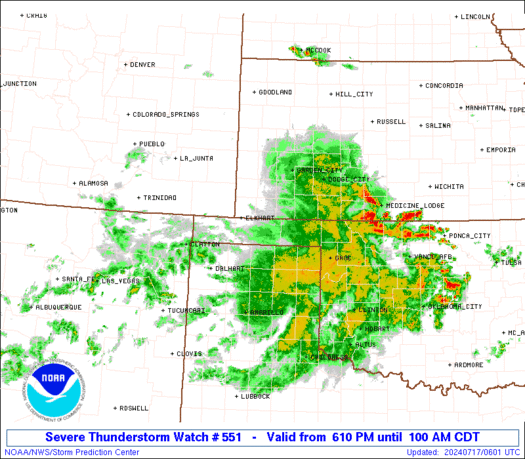
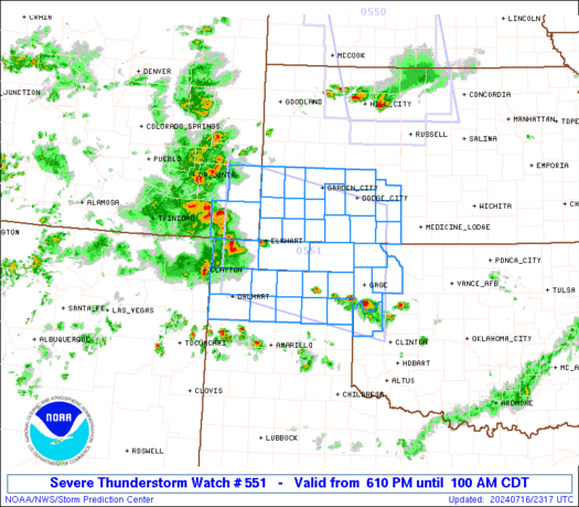
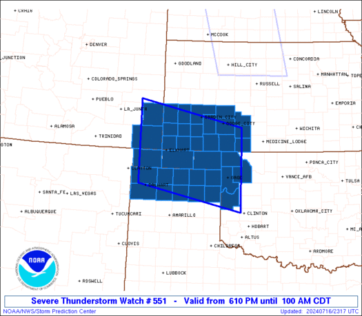
Severe Thunderstorm Watch Number 551
NWS Storm Prediction Center Norman OK
610 PM CDT Tue Jul 16 2024
The NWS Storm Prediction Center has issued a
* Severe Thunderstorm Watch for portions of
Far Southeast Colorado
Southwest Kansas
Northwest Oklahoma
Northern Texas Panhandle
* Effective this Tuesday night and Wednesday morning from 610 PM
until 100 AM CDT.
* Primary threats include...
Scattered large hail and isolated very large hail events to 2
inches in diameter possible
Scattered damaging wind gusts to 70 mph possible
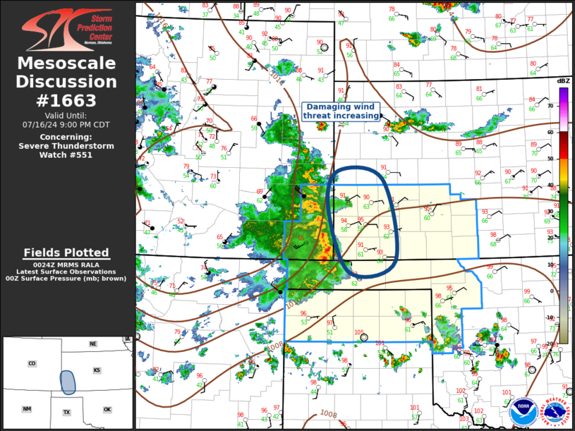
SUMMARY...Severe thunderstorms are expected to increase in coverage
and move generally east across the watch area this evening, with a
risk for damaging wind gusts and isolated large hail.
The severe thunderstorm watch area is approximately along and 80
statute miles north and south of a line from 10 miles west southwest
of Springfield CO to 95 miles south southeast of Dodge City KS. For
a complete depiction of the watch see the associated watch outline
update (WOUS64 KWNS WOU1).
PRECAUTIONARY/PREPAREDNESS ACTIONS...
REMEMBER...A Severe Thunderstorm Watch means conditions are
favorable for severe thunderstorms in and close to the watch area.
Persons in these areas should be on the lookout for threatening
weather conditions and listen for later statements and possible
warnings. Severe thunderstorms can and occasionally do produce
tornadoes.
&&
OTHER WATCH INFORMATION...CONTINUE...WW 547...WW 548...WW
549...WW 550...
AVIATION...A few severe thunderstorms with hail surface and aloft to
2 inches. Extreme turbulence and surface wind gusts to 60 knots. A
few cumulonimbi with maximum tops to 550. Mean storm motion vector
27030.
...Bunting
   SEL1

   URGENT - IMMEDIATE BROADCAST REQUESTED
   Severe Thunderstorm Watch Number 551
   NWS Storm Prediction Center Norman OK
   610 PM CDT Tue Jul 16 2024

   The NWS Storm Prediction Center has issued a

   * Severe Thunderstorm Watch for portions of
     Far Southeast Colorado
     Southwest Kansas
     Northwest Oklahoma
     Northern Texas Panhandle

   * Effective this Tuesday night and Wednesday morning from 610 PM
     until 100 AM CDT.

   * Primary threats include...
     Scattered large hail and isolated very large hail events to 2
       inches in diameter possible
     Scattered damaging wind gusts to 70 mph possible

   SUMMARY...Severe thunderstorms are expected to increase in coverage
   and move generally east across the watch area this evening, with a
   risk for damaging wind gusts and isolated large hail.

   The severe thunderstorm watch area is approximately along and 80
   statute miles north and south of a line from 10 miles west southwest
   of Springfield CO to 95 miles south southeast of Dodge City KS. For
   a complete depiction of the watch see the associated watch outline
   update (WOUS64 KWNS WOU1).

   PRECAUTIONARY/PREPAREDNESS ACTIONS...

   REMEMBER...A Severe Thunderstorm Watch means conditions are
   favorable for severe thunderstorms in and close to the watch area.
   Persons in these areas should be on the lookout for threatening
   weather conditions and listen for later statements and possible
   warnings. Severe thunderstorms can and occasionally do produce
   tornadoes.

   &&

   OTHER WATCH INFORMATION...CONTINUE...WW 547...WW 548...WW
   549...WW 550...

   AVIATION...A few severe thunderstorms with hail surface and aloft to
   2 inches. Extreme turbulence and surface wind gusts to 60 knots. A
   few cumulonimbi with maximum tops to 550. Mean storm motion vector
   27030.

   ...Bunting
 Note:
The Aviation Watch (SAW) product is an approximation to the watch area.
The actual watch is depicted by the shaded areas.
Note:
The Aviation Watch (SAW) product is an approximation to the watch area.
The actual watch is depicted by the shaded areas.
   SAW1
   WW 551 SEVERE TSTM CO KS OK TX 162310Z - 170600Z
   AXIS..80 STATUTE MILES NORTH AND SOUTH OF LINE..
   10WSW SPD/SPRINGFIELD CO/ - 95SSE DDC/DODGE CITY KS/
   ..AVIATION COORDS.. 70NM N/S /39E TBE - 29ENE MMB/
   HAIL SURFACE AND ALOFT..2 INCHES. WIND GUSTS..60 KNOTS.
   MAX TOPS TO 550. MEAN STORM MOTION VECTOR 27030.

   LAT...LON 38380279 37669932 35349932 36070279

   THIS IS AN APPROXIMATION TO THE WATCH AREA.  FOR A
   COMPLETE DEPICTION OF THE WATCH SEE WOUS64 KWNS
   FOR WOU1.
Watch 551 Status Report Messages:
STATUS REPORT #3 ON WW 551

VALID 170350Z - 170440Z

SEVERE WEATHER THREAT CONTINUES RIGHT OF A LINE FROM 15 ESE DHT
TO 10 WNW GUY TO 35 NW LBL TO 45 WSW GCK TO 45 E LAA.

..SPC..07/17/24

ATTN...WFO...PUB...DDC...AMA...OUN...

&&

STATUS REPORT FOR WS 551

SEVERE WEATHER THREAT CONTINUES FOR THE FOLLOWING AREAS

KSC025-033-047-055-057-067-069-081-083-093-097-119-175-189-
170440-

KS
.    KANSAS COUNTIES INCLUDED ARE

CLARK		     COMANCHE		 EDWARDS
FINNEY		     FORD		 GRANT
GRAY		     HASKELL		 HODGEMAN
KEARNY		     KIOWA		 MEADE
SEWARD		     STEVENS
$$


OKC007-045-059-129-139-153-170440-

OK
.    OKLAHOMA COUNTIES INCLUDED ARE

BEAVER		     ELLIS		 HARPER
ROGER MILLS	     TEXAS		 WOODWARD
$$


TXC195-211-233-295-341-357-393-421-170440-

TX
.    TEXAS COUNTIES INCLUDED ARE

HANSFORD	     HEMPHILL		 HUTCHINSON
LIPSCOMB	     MOORE		 OCHILTREE
ROBERTS 	     SHERMAN
$$


THE WATCH STATUS MESSAGE IS FOR GUIDANCE PURPOSES ONLY.  PLEASE
REFER TO WATCH COUNTY NOTIFICATION STATEMENTS FOR OFFICIAL
INFORMATION ON COUNTIES...INDEPENDENT CITIES AND MARINE ZONES
CLEARED FROM SEVERE THUNDERSTORM AND TORNADO WATCHES.
$$

STATUS REPORT #2 ON WW 551

VALID 170205Z - 170340Z

SEVERE WEATHER THREAT CONTINUES RIGHT OF A LINE FROM 5 E DHT TO
20 W GUY TO 35 NE EHA TO 40 ENE LAA.

..SPC..07/17/24

ATTN...WFO...PUB...DDC...AMA...OUN...

&&

STATUS REPORT FOR WS 551

SEVERE WEATHER THREAT CONTINUES FOR THE FOLLOWING AREAS

KSC025-033-047-055-057-067-069-075-081-083-093-097-119-129-175-
187-189-170340-

KS
.    KANSAS COUNTIES INCLUDED ARE

CLARK		     COMANCHE		 EDWARDS
FINNEY		     FORD		 GRANT
GRAY		     HAMILTON		 HASKELL
HODGEMAN	     KEARNY		 KIOWA
MEADE		     MORTON		 SEWARD
STANTON 	     STEVENS
$$


OKC007-045-059-129-139-153-170340-

OK
.    OKLAHOMA COUNTIES INCLUDED ARE

BEAVER		     ELLIS		 HARPER
ROGER MILLS	     TEXAS		 WOODWARD
$$


TXC195-205-211-233-295-341-357-393-421-170340-

TX
.    TEXAS COUNTIES INCLUDED ARE

HANSFORD	     HARTLEY		 HEMPHILL
HUTCHINSON	     LIPSCOMB		 MOORE
OCHILTREE	     ROBERTS		 SHERMAN
$$


THE WATCH STATUS MESSAGE IS FOR GUIDANCE PURPOSES ONLY.  PLEASE
REFER TO WATCH COUNTY NOTIFICATION STATEMENTS FOR OFFICIAL
INFORMATION ON COUNTIES...INDEPENDENT CITIES AND MARINE ZONES
CLEARED FROM SEVERE THUNDERSTORM AND TORNADO WATCHES.
$$

STATUS REPORT #1 ON WW 551

VALID 170100Z - 170240Z

SEVERE WEATHER THREAT CONTINUES RIGHT OF A LINE FROM 20 NW DHT TO
25 WSW EHA TO 35 NE SPD TO 20 NNE LAA.

..SPC..07/17/24

ATTN...WFO...PUB...DDC...AMA...OUN...

&&

STATUS REPORT FOR WS 551

SEVERE WEATHER THREAT CONTINUES FOR THE FOLLOWING AREAS

COC009-099-170240-

CO
.    COLORADO COUNTIES INCLUDED ARE

BACA		     PROWERS
$$


KSC025-033-047-055-057-067-069-075-081-083-093-097-119-129-175-
187-189-170240-

KS
.    KANSAS COUNTIES INCLUDED ARE

CLARK		     COMANCHE		 EDWARDS
FINNEY		     FORD		 GRANT
GRAY		     HAMILTON		 HASKELL
HODGEMAN	     KEARNY		 KIOWA
MEADE		     MORTON		 SEWARD
STANTON 	     STEVENS
$$


OKC007-025-045-059-129-139-153-170240-

OK
.    OKLAHOMA COUNTIES INCLUDED ARE

BEAVER		     CIMARRON		 ELLIS
HARPER		     ROGER MILLS	 TEXAS
WOODWARD
$$


TXC111-195-205-211-233-295-341-357-393-421-170240-

TX
.    TEXAS COUNTIES INCLUDED ARE

DALLAM		     HANSFORD		 HARTLEY
HEMPHILL	     HUTCHINSON 	 LIPSCOMB
MOORE		     OCHILTREE		 ROBERTS
SHERMAN
$$


THE WATCH STATUS MESSAGE IS FOR GUIDANCE PURPOSES ONLY.  PLEASE
REFER TO WATCH COUNTY NOTIFICATION STATEMENTS FOR OFFICIAL
INFORMATION ON COUNTIES...INDEPENDENT CITIES AND MARINE ZONES
CLEARED FROM SEVERE THUNDERSTORM AND TORNADO WATCHES.
$$
Note:
Click for Complete Product Text.
Tornadoes
Probability of 2 or more tornadoes
|
Low (10%)
|
Probability of 1 or more strong (EF2-EF5) tornadoes
|
Low (<2%)
|
Wind
Probability of 10 or more severe wind events
|
Mod (40%)
|
Probability of 1 or more wind events > 65 knots
|
Low (20%)
|
Hail
Probability of 10 or more severe hail events
|
Mod (40%)
|
Probability of 1 or more hailstones > 2 inches
|
Mod (30%)
|
Combined Severe Hail/Wind
Probability of 6 or more combined severe hail/wind events
|
High (70%)
|
For each watch, probabilities for particular events inside the watch
(listed above in each table) are determined by the issuing forecaster.
The "Low" category contains probability values ranging from less than 2%
to 20% (EF2-EF5 tornadoes), less than 5% to 20% (all other probabilities),
"Moderate" from 30% to 60%, and "High" from 70% to greater than 95%.
High values are bolded and lighter in color to provide awareness of
an increased threat for a particular event.


 @NWSSPC