Note:
The expiration time in the watch graphic is amended if the watch is
replaced, cancelled or extended.
Note:
Note:
The expiration time in the watch graphic is amended if the watch is
replaced, cancelled or extended.
Note: Click for
Watch Status Reports.
SEL9
URGENT - IMMEDIATE BROADCAST REQUESTED
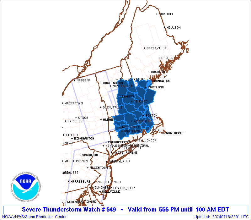
Severe Thunderstorm Watch Number 549
NWS Storm Prediction Center Norman OK
555 PM EDT Tue Jul 16 2024
The NWS Storm Prediction Center has issued a
* Severe Thunderstorm Watch for portions of
Northern Connecticut
Central and Eastern Massachusetts
Far Southern Maine
Central and Southern New Hampshire
Northern Rhode Island
Coastal Waters
* Effective this Tuesday afternoon and Wednesday morning from 555
PM until 100 AM EDT.
* Primary threats include...
Scattered damaging wind gusts to 70 mph possible
Isolated large hail events to 1 inch in diameter possible
A tornado or two possible
SUMMARY...A line of severe thunderstorms will continue moving
rapidly east across the watch area this evening, posing a risk for
damaging thunderstorm wind gusts to 70 mph, and perhaps isolated
hail.
The severe thunderstorm watch area is approximately along and 60
statute miles east and west of a line from 30 miles north northwest
of Laconia NH to 25 miles southeast of Worcester MA. For a complete
depiction of the watch see the associated watch outline update
(WOUS64 KWNS WOU9).
PRECAUTIONARY/PREPAREDNESS ACTIONS...
REMEMBER...A Severe Thunderstorm Watch means conditions are
favorable for severe thunderstorms in and close to the watch area.
Persons in these areas should be on the lookout for threatening
weather conditions and listen for later statements and possible
warnings. Severe thunderstorms can and occasionally do produce
tornadoes.
&&
OTHER WATCH INFORMATION...CONTINUE...WW 547...WW 548...
AVIATION...A few severe thunderstorms with hail surface and aloft to
1 inch. Extreme turbulence and surface wind gusts to 60 knots. A few
cumulonimbi with maximum tops to 500. Mean storm motion vector
27040.
...Bunting

   SEL9

   URGENT - IMMEDIATE BROADCAST REQUESTED
   Severe Thunderstorm Watch Number 549
   NWS Storm Prediction Center Norman OK
   555 PM EDT Tue Jul 16 2024

   The NWS Storm Prediction Center has issued a

   * Severe Thunderstorm Watch for portions of
     Northern Connecticut
     Central and Eastern Massachusetts
     Far Southern Maine
     Central and Southern New Hampshire
     Northern Rhode Island
     Coastal Waters

   * Effective this Tuesday afternoon and Wednesday morning from 555
     PM until 100 AM EDT.

   * Primary threats include...
     Scattered damaging wind gusts to 70 mph possible
     Isolated large hail events to 1 inch in diameter possible
     A tornado or two possible

   SUMMARY...A line of severe thunderstorms will continue moving
   rapidly east across the watch area this evening, posing a risk for
   damaging thunderstorm wind gusts to 70 mph, and perhaps isolated
   hail.

   The severe thunderstorm watch area is approximately along and 60
   statute miles east and west of a line from 30 miles north northwest
   of Laconia NH to 25 miles southeast of Worcester MA. For a complete
   depiction of the watch see the associated watch outline update
   (WOUS64 KWNS WOU9).

   PRECAUTIONARY/PREPAREDNESS ACTIONS...

   REMEMBER...A Severe Thunderstorm Watch means conditions are
   favorable for severe thunderstorms in and close to the watch area.
   Persons in these areas should be on the lookout for threatening
   weather conditions and listen for later statements and possible
   warnings. Severe thunderstorms can and occasionally do produce
   tornadoes.

   &&

   OTHER WATCH INFORMATION...CONTINUE...WW 547...WW 548...

   AVIATION...A few severe thunderstorms with hail surface and aloft to
   1 inch. Extreme turbulence and surface wind gusts to 60 knots. A few
   cumulonimbi with maximum tops to 500. Mean storm motion vector
   27040.

   ...Bunting
 Note:
The Aviation Watch (SAW) product is an approximation to the watch area.
The actual watch is depicted by the shaded areas.
Note:
The Aviation Watch (SAW) product is an approximation to the watch area.
The actual watch is depicted by the shaded areas.
   SAW9
   WW 549 SEVERE TSTM CT MA ME NH RI CW 162155Z - 170500Z
   AXIS..60 STATUTE MILES EAST AND WEST OF LINE..
   30NNW LCI/LACONIA NH/ - 25SE ORH/WORCESTER MA/
   ..AVIATION COORDS.. 50NM E/W /42ESE MPV - 18NNW PVD/
   HAIL SURFACE AND ALOFT..1 INCH. WIND GUSTS..60 KNOTS.
   MAX TOPS TO 500. MEAN STORM MOTION VECTOR 27040.

   LAT...LON 43967044 42017037 42017269 43967286

   THIS IS AN APPROXIMATION TO THE WATCH AREA.  FOR A
   COMPLETE DEPICTION OF THE WATCH SEE WOUS64 KWNS
   FOR WOU9.
Watch 549 Status Report Messages:
STATUS REPORT #3 ON WW 549
VALID 170145Z - 170240Z
SEVERE WEATHER THREAT CONTINUES RIGHT OF A LINE FROM 30 NE BDR TO
10 NW BOS TO 10 WNW PSM.
..MOORE..07/17/24
ATTN...WFO...BOX...GYX...
&&
STATUS REPORT FOR WS 549
SEVERE WEATHER THREAT CONTINUES FOR THE FOLLOWING AREAS
CTC013-015-170240-
CT
. CONNECTICUT COUNTIES INCLUDED ARE
TOLLAND WINDHAM
$$
MAC005-009-021-023-025-170240-
MA
. MASSACHUSETTS COUNTIES INCLUDED ARE
BRISTOL ESSEX NORFOLK
PLYMOUTH SUFFOLK
$$
RIC003-007-170240-
RI
. RHODE ISLAND COUNTIES INCLUDED ARE
KENT PROVIDENCE
$$
ANZ230-251-170240-
CW
. ADJACENT COASTAL WATERS INCLUDED ARE
BOSTON HARBOR
MASSACHUSETTS BAY AND IPSWICH BAY
$$
THE WATCH STATUS MESSAGE IS FOR GUIDANCE PURPOSES ONLY. PLEASE
REFER TO WATCH COUNTY NOTIFICATION STATEMENTS FOR OFFICIAL
INFORMATION ON COUNTIES...INDEPENDENT CITIES AND MARINE ZONES
CLEARED FROM SEVERE THUNDERSTORM AND TORNADO WATCHES.
$$
STATUS REPORT #2 ON WW 549
VALID 170035Z - 170140Z
SEVERE WEATHER THREAT CONTINUES RIGHT OF A LINE FROM 30 WSW BAF
TO 25 S EEN TO CON TO 10 ESE LCI TO 20 E MWN.
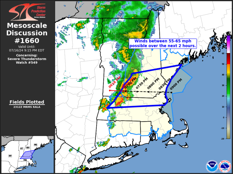
FOR ADDITIONAL INFORMATION SEE MESOSCALE DISCUSSION 1660
..MOORE..07/17/24
ATTN...WFO...BOX...GYX...
&&
STATUS REPORT FOR WS 549
SEVERE WEATHER THREAT CONTINUES FOR THE FOLLOWING AREAS
CTC003-013-015-170140-
CT
. CONNECTICUT COUNTIES INCLUDED ARE
HARTFORD TOLLAND WINDHAM
$$
MEC005-031-170140-
ME
. MAINE COUNTIES INCLUDED ARE
CUMBERLAND YORK
$$
MAC005-009-013-015-017-021-023-025-027-170140-
MA
. MASSACHUSETTS COUNTIES INCLUDED ARE
BRISTOL ESSEX HAMPDEN
HAMPSHIRE MIDDLESEX NORFOLK
PLYMOUTH SUFFOLK WORCESTER
$$
NHC011-015-017-170140-
NH
. NEW HAMPSHIRE COUNTIES INCLUDED ARE
HILLSBOROUGH ROCKINGHAM STRAFFORD
$$
RIC003-007-170140-
RI
. RHODE ISLAND COUNTIES INCLUDED ARE
KENT PROVIDENCE
$$
ANZ153-154-230-251-170140-
CW
. ADJACENT COASTAL WATERS INCLUDED ARE
CASCO BAY
COASTAL WATERS FROM CAPE ELIZABETH ME TO MERRIMACK RIVER MA OUT
25 NM
BOSTON HARBOR
MASSACHUSETTS BAY AND IPSWICH BAY
$$
THE WATCH STATUS MESSAGE IS FOR GUIDANCE PURPOSES ONLY. PLEASE
REFER TO WATCH COUNTY NOTIFICATION STATEMENTS FOR OFFICIAL
INFORMATION ON COUNTIES...INDEPENDENT CITIES AND MARINE ZONES
CLEARED FROM SEVERE THUNDERSTORM AND TORNADO WATCHES.
$$
STATUS REPORT #1 ON WW 549
VALID 162325Z - 170040Z
SEVERE WEATHER THREAT CONTINUES RIGHT OF A LINE FROM 10 WSW PSF
TO 25 W CON TO 20 NNW LCI TO 10 N MWN.
FOR ADDITIONAL INFORMATION SEE MESOSCALE DISCUSSION 1660
..MOORE..07/16/24
ATTN...WFO...BOX...GYX...
&&
STATUS REPORT FOR WS 549
SEVERE WEATHER THREAT CONTINUES FOR THE FOLLOWING AREAS
CTC003-013-015-170040-
CT
. CONNECTICUT COUNTIES INCLUDED ARE
HARTFORD TOLLAND WINDHAM
$$
MEC005-031-170040-
ME
. MAINE COUNTIES INCLUDED ARE
CUMBERLAND YORK
$$
MAC005-009-011-013-015-017-021-023-025-027-170040-
MA
. MASSACHUSETTS COUNTIES INCLUDED ARE
BRISTOL ESSEX FRANKLIN
HAMPDEN HAMPSHIRE MIDDLESEX
NORFOLK PLYMOUTH SUFFOLK
WORCESTER
$$
NHC001-003-005-011-013-015-017-170040-
NH
. NEW HAMPSHIRE COUNTIES INCLUDED ARE
BELKNAP CARROLL CHESHIRE
HILLSBOROUGH MERRIMACK ROCKINGHAM
STRAFFORD
$$
RIC003-007-170040-
RI
. RHODE ISLAND COUNTIES INCLUDED ARE
KENT PROVIDENCE
$$
ANZ153-154-230-251-170040-
CW
. ADJACENT COASTAL WATERS INCLUDED ARE
CASCO BAY
COASTAL WATERS FROM CAPE ELIZABETH ME TO MERRIMACK RIVER MA OUT
25 NM
BOSTON HARBOR
MASSACHUSETTS BAY AND IPSWICH BAY
$$
THE WATCH STATUS MESSAGE IS FOR GUIDANCE PURPOSES ONLY. PLEASE
REFER TO WATCH COUNTY NOTIFICATION STATEMENTS FOR OFFICIAL
INFORMATION ON COUNTIES...INDEPENDENT CITIES AND MARINE ZONES
CLEARED FROM SEVERE THUNDERSTORM AND TORNADO WATCHES.
$$
Note:
Click for Complete Product Text.
Tornadoes
Probability of 2 or more tornadoes
|
Low (20%)
|
Probability of 1 or more strong (EF2-EF5) tornadoes
|
Low (<2%)
|
Wind
Probability of 10 or more severe wind events
|
Mod (40%)
|
Probability of 1 or more wind events > 65 knots
|
Low (20%)
|
Hail
Probability of 10 or more severe hail events
|
Low (20%)
|
Probability of 1 or more hailstones > 2 inches
|
Low (10%)
|
Combined Severe Hail/Wind
Probability of 6 or more combined severe hail/wind events
|
Mod (60%)
|
For each watch, probabilities for particular events inside the watch
(listed above in each table) are determined by the issuing forecaster.
The "Low" category contains probability values ranging from less than 2%
to 20% (EF2-EF5 tornadoes), less than 5% to 20% (all other probabilities),
"Moderate" from 30% to 60%, and "High" from 70% to greater than 95%.
High values are bolded and lighter in color to provide awareness of
an increased threat for a particular event.


 @NWSSPC