Note:
The expiration time in the watch graphic is amended if the watch is
replaced, cancelled or extended.
Note:
Note:
The expiration time in the watch graphic is amended if the watch is
replaced, cancelled or extended.
Note: Click for
Watch Status Reports.
SEL0
URGENT - IMMEDIATE BROADCAST REQUESTED
Severe Thunderstorm Watch Number 550
NWS Storm Prediction Center Norman OK
510 PM CDT Tue Jul 16 2024
The NWS Storm Prediction Center has issued a
* Severe Thunderstorm Watch for portions of
North-central Kansas
Central Nebraska
* Effective this Tuesday afternoon from 510 PM until Midnight
CDT.
* Primary threats include...
Scattered large hail and isolated very large hail events to 2.5
inches in diameter possible
Scattered damaging wind gusts to 70 mph possible
A tornado or two possible
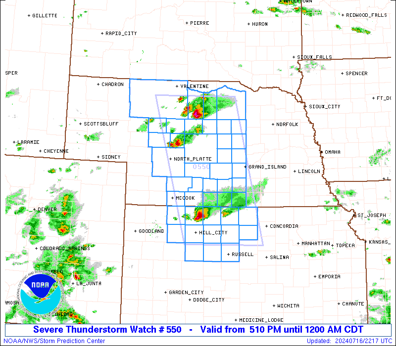
SUMMARY...Isolated severe thunderstorms will continue moving
southeast across the watch area this evening, with a risk for very
large hail and damaging thunderstorm gusts.
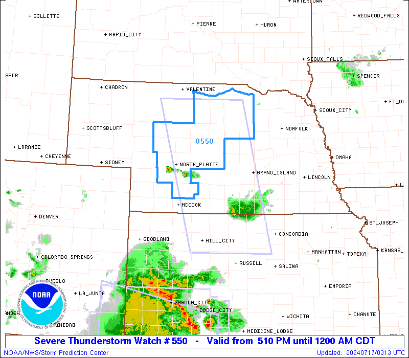
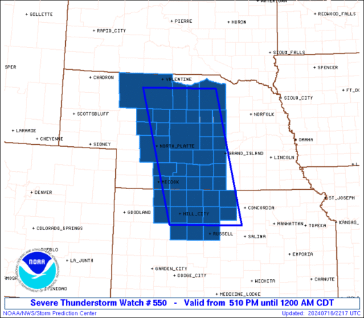
The severe thunderstorm watch area is approximately along and 65
statute miles east and west of a line from 5 miles north northeast
of Ainsworth NE to 50 miles east southeast of Hill City KS. For a
complete depiction of the watch see the associated watch outline
update (WOUS64 KWNS WOU0).
PRECAUTIONARY/PREPAREDNESS ACTIONS...
REMEMBER...A Severe Thunderstorm Watch means conditions are
favorable for severe thunderstorms in and close to the watch area.
Persons in these areas should be on the lookout for threatening
weather conditions and listen for later statements and possible
warnings. Severe thunderstorms can and occasionally do produce
tornadoes.
&&
OTHER WATCH INFORMATION...CONTINUE...WW 547...WW 548...WW 549...
AVIATION...A few severe thunderstorms with hail surface and aloft to
2.5 inches. Extreme turbulence and surface wind gusts to 60 knots. A
few cumulonimbi with maximum tops to 550. Mean storm motion vector
31035.
...Bunting

   SEL0

   URGENT - IMMEDIATE BROADCAST REQUESTED
   Severe Thunderstorm Watch Number 550
   NWS Storm Prediction Center Norman OK
   510 PM CDT Tue Jul 16 2024

   The NWS Storm Prediction Center has issued a

   * Severe Thunderstorm Watch for portions of
     North-central Kansas
     Central Nebraska

   * Effective this Tuesday afternoon from 510 PM until Midnight
     CDT.

   * Primary threats include...
     Scattered large hail and isolated very large hail events to 2.5
       inches in diameter possible
     Scattered damaging wind gusts to 70 mph possible
     A tornado or two possible

   SUMMARY...Isolated severe thunderstorms will continue moving
   southeast across the watch area this evening, with a risk for very
   large hail and damaging thunderstorm gusts.

   The severe thunderstorm watch area is approximately along and 65
   statute miles east and west of a line from 5 miles north northeast
   of Ainsworth NE to 50 miles east southeast of Hill City KS. For a
   complete depiction of the watch see the associated watch outline
   update (WOUS64 KWNS WOU0).

   PRECAUTIONARY/PREPAREDNESS ACTIONS...

   REMEMBER...A Severe Thunderstorm Watch means conditions are
   favorable for severe thunderstorms in and close to the watch area.
   Persons in these areas should be on the lookout for threatening
   weather conditions and listen for later statements and possible
   warnings. Severe thunderstorms can and occasionally do produce
   tornadoes.

   &&

   OTHER WATCH INFORMATION...CONTINUE...WW 547...WW 548...WW 549...

   AVIATION...A few severe thunderstorms with hail surface and aloft to
   2.5 inches. Extreme turbulence and surface wind gusts to 60 knots. A
   few cumulonimbi with maximum tops to 550. Mean storm motion vector
   31035.

   ...Bunting
 Note:
The Aviation Watch (SAW) product is an approximation to the watch area.
The actual watch is depicted by the shaded areas.
Note:
The Aviation Watch (SAW) product is an approximation to the watch area.
The actual watch is depicted by the shaded areas.
   SAW0
   WW 550 SEVERE TSTM KS NE 162210Z - 170500Z
   AXIS..65 STATUTE MILES EAST AND WEST OF LINE..
   5NNE ANW/AINSWORTH NE/ - 50ESE HLC/HILL CITY KS/
   ..AVIATION COORDS.. 55NM E/W /5NNE ANW - 59E HLC/
   HAIL SURFACE AND ALOFT..2.5 INCHES. WIND GUSTS..60 KNOTS.
   MAX TOPS TO 550. MEAN STORM MOTION VECTOR 31035.

   LAT...LON 42649866 39099776 39090018 42640122

   THIS IS AN APPROXIMATION TO THE WATCH AREA.  FOR A
   COMPLETE DEPICTION OF THE WATCH SEE WOUS64 KWNS
   FOR WOU0.
Watch 550 Status Report Messages:
STATUS REPORT #3 ON WW 550

VALID 170215Z - 170340Z

SEVERE WEATHER THREAT CONTINUES RIGHT OF A LINE FROM 30 S LBF TO
15 ESE EAR TO 30 NE RSL.

..SPC..07/17/24

ATTN...WFO...GLD...DDC...GID...ICT...LBF...

&&

STATUS REPORT FOR WS 550

SEVERE WEATHER THREAT CONTINUES FOR THE FOLLOWING AREAS

KSC039-051-065-137-141-147-163-167-179-183-195-170340-

KS
.    KANSAS COUNTIES INCLUDED ARE

DECATUR 	     ELLIS		 GRAHAM
NORTON		     OSBORNE		 PHILLIPS
ROOKS		     RUSSELL		 SHERIDAN
SMITH		     TREGO
$$


NEC061-063-065-073-083-099-137-145-170340-

NE
.    NEBRASKA COUNTIES INCLUDED ARE

FRANKLIN	     FRONTIER		 FURNAS
GOSPER		     HARLAN		 KEARNEY
PHELPS		     RED WILLOW
$$


THE WATCH STATUS MESSAGE IS FOR GUIDANCE PURPOSES ONLY.  PLEASE
REFER TO WATCH COUNTY NOTIFICATION STATEMENTS FOR OFFICIAL
INFORMATION ON COUNTIES...INDEPENDENT CITIES AND MARINE ZONES
CLEARED FROM SEVERE THUNDERSTORM AND TORNADO WATCHES.
$$

STATUS REPORT #2 ON WW 550

VALID 170100Z - 170240Z

SEVERE WEATHER THREAT CONTINUES RIGHT OF A LINE FROM 15 NNW LBF
TO 25 ESE BBW TO 15 WNW HSI TO 25 NE RSL.

..SPC..07/17/24

ATTN...WFO...GLD...DDC...GID...ICT...LBF...

&&

STATUS REPORT FOR WS 550

SEVERE WEATHER THREAT CONTINUES FOR THE FOLLOWING AREAS

KSC039-051-065-137-141-147-163-167-179-183-195-170240-

KS
.    KANSAS COUNTIES INCLUDED ARE

DECATUR 	     ELLIS		 GRAHAM
NORTON		     OSBORNE		 PHILLIPS
ROOKS		     RUSSELL		 SHERIDAN
SMITH		     TREGO
$$


NEC019-047-061-063-065-073-083-099-111-137-145-170240-

NE
.    NEBRASKA COUNTIES INCLUDED ARE

BUFFALO 	     DAWSON		 FRANKLIN
FRONTIER	     FURNAS		 GOSPER
HARLAN		     KEARNEY		 LINCOLN
PHELPS		     RED WILLOW
$$


THE WATCH STATUS MESSAGE IS FOR GUIDANCE PURPOSES ONLY.  PLEASE
REFER TO WATCH COUNTY NOTIFICATION STATEMENTS FOR OFFICIAL
INFORMATION ON COUNTIES...INDEPENDENT CITIES AND MARINE ZONES
CLEARED FROM SEVERE THUNDERSTORM AND TORNADO WATCHES.
$$

STATUS REPORT #1 ON WW 550

VALID 162340Z - 170040Z

SEVERE WEATHER THREAT CONTINUES RIGHT OF A LINE FROM 15 SSE MHN
TO 35 E MHN TO 40 ESE BUB.

..SPC..07/16/24

ATTN...WFO...GLD...DDC...GID...ICT...LBF...

&&

STATUS REPORT FOR WS 550

SEVERE WEATHER THREAT CONTINUES FOR THE FOLLOWING AREAS

KSC039-051-065-089-123-137-141-147-163-167-179-183-195-170040-

KS
.    KANSAS COUNTIES INCLUDED ARE

DECATUR 	     ELLIS		 GRAHAM
JEWELL		     MITCHELL		 NORTON
OSBORNE 	     PHILLIPS		 ROOKS
RUSSELL 	     SHERIDAN		 SMITH
TREGO
$$


NEC001-009-019-041-047-061-063-065-073-077-079-083-093-099-111-
113-115-117-137-145-163-171-175-181-170040-

NE
.    NEBRASKA COUNTIES INCLUDED ARE

ADAMS		     BLAINE		 BUFFALO
CUSTER		     DAWSON		 FRANKLIN
FRONTIER	     FURNAS		 GOSPER
GREELEY 	     HALL		 HARLAN
HOWARD		     KEARNEY		 LINCOLN
LOGAN		     LOUP		 MCPHERSON
PHELPS		     RED WILLOW 	 SHERMAN
THOMAS		     VALLEY		 WEBSTER
$$


THE WATCH STATUS MESSAGE IS FOR GUIDANCE PURPOSES ONLY.  PLEASE
REFER TO WATCH COUNTY NOTIFICATION STATEMENTS FOR OFFICIAL
INFORMATION ON COUNTIES...INDEPENDENT CITIES AND MARINE ZONES
CLEARED FROM SEVERE THUNDERSTORM AND TORNADO WATCHES.
$$
Note:
Click for Complete Product Text.
Tornadoes
Probability of 2 or more tornadoes
|
Low (20%)
|
Probability of 1 or more strong (EF2-EF5) tornadoes
|
Low (<2%)
|
Wind
Probability of 10 or more severe wind events
|
Mod (40%)
|
Probability of 1 or more wind events > 65 knots
|
Low (20%)
|
Hail
Probability of 10 or more severe hail events
|
Mod (40%)
|
Probability of 1 or more hailstones > 2 inches
|
Mod (30%)
|
Combined Severe Hail/Wind
Probability of 6 or more combined severe hail/wind events
|
High (70%)
|
For each watch, probabilities for particular events inside the watch
(listed above in each table) are determined by the issuing forecaster.
The "Low" category contains probability values ranging from less than 2%
to 20% (EF2-EF5 tornadoes), less than 5% to 20% (all other probabilities),
"Moderate" from 30% to 60%, and "High" from 70% to greater than 95%.
High values are bolded and lighter in color to provide awareness of
an increased threat for a particular event.


 @NWSSPC