 Note:
The expiration time in the watch graphic is amended if the watch is
replaced, cancelled or extended.
Note:
Note:
The expiration time in the watch graphic is amended if the watch is
replaced, cancelled or extended.
Note: Click for
Watch Status Reports.
SEL9
URGENT - IMMEDIATE BROADCAST REQUESTED
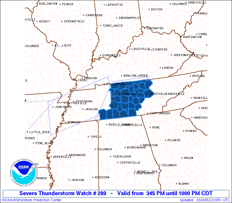
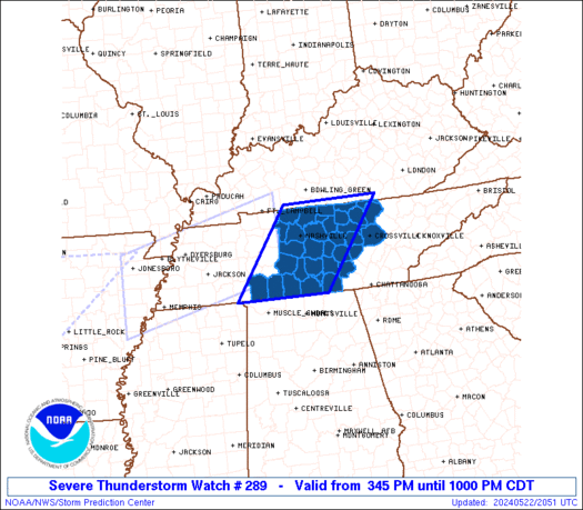
Severe Thunderstorm Watch Number 289
NWS Storm Prediction Center Norman OK
345 PM CDT Wed May 22 2024
The NWS Storm Prediction Center has issued a
* Severe Thunderstorm Watch for portions of
Western and Middle Tennessee
* Effective this Wednesday afternoon and evening from 345 PM
until 1000 PM CDT.
* Primary threats include...
Scattered damaging wind gusts to 70 mph possible
Scattered large hail events to 1.5 inches in diameter possible
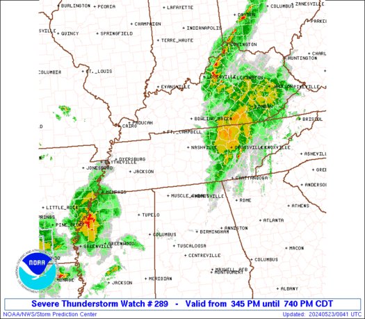
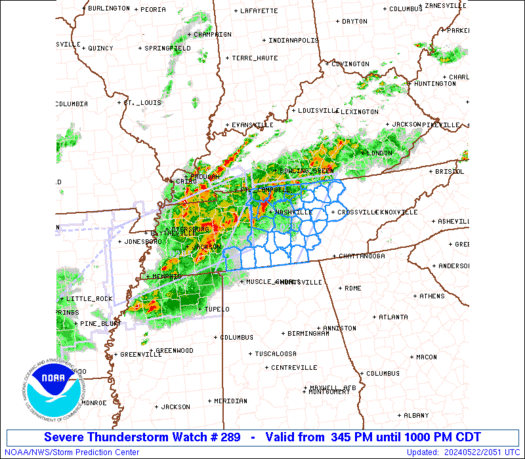
SUMMARY...A bowing complex of thunderstorms will move east across
the watch area the remainder of this afternoon and evening, posing a
risk for damaging wind gusts and large hail.
The severe thunderstorm watch area is approximately along and 60
statute miles east and west of a line from 85 miles south southwest
of Nashville TN to 60 miles northeast of Nashville TN. For a
complete depiction of the watch see the associated watch outline
update (WOUS64 KWNS WOU9).
PRECAUTIONARY/PREPAREDNESS ACTIONS...
REMEMBER...A Severe Thunderstorm Watch means conditions are
favorable for severe thunderstorms in and close to the watch area.
Persons in these areas should be on the lookout for threatening
weather conditions and listen for later statements and possible
warnings. Severe thunderstorms can and occasionally do produce
tornadoes.
&&
OTHER WATCH INFORMATION...CONTINUE...WW 284...WW 285...WW
286...WW 287...WW 288...
AVIATION...A few severe thunderstorms with hail surface and aloft to
1.5 inches. Extreme turbulence and surface wind gusts to 60 knots. A
few cumulonimbi with maximum tops to 500. Mean storm motion vector
26030.
...Hart
   SEL9

   URGENT - IMMEDIATE BROADCAST REQUESTED
   Severe Thunderstorm Watch Number 289
   NWS Storm Prediction Center Norman OK
   345 PM CDT Wed May 22 2024

   The NWS Storm Prediction Center has issued a

   * Severe Thunderstorm Watch for portions of
     Western and Middle Tennessee

   * Effective this Wednesday afternoon and evening from 345 PM
     until 1000 PM CDT.

   * Primary threats include...
     Scattered damaging wind gusts to 70 mph possible
     Scattered large hail events to 1.5 inches in diameter possible

   SUMMARY...A bowing complex of thunderstorms will move east across
   the watch area the remainder of this afternoon and evening, posing a
   risk for damaging wind gusts and large hail.

   The severe thunderstorm watch area is approximately along and 60
   statute miles east and west of a line from 85 miles south southwest
   of Nashville TN to 60 miles northeast of Nashville TN. For a
   complete depiction of the watch see the associated watch outline
   update (WOUS64 KWNS WOU9).

   PRECAUTIONARY/PREPAREDNESS ACTIONS...

   REMEMBER...A Severe Thunderstorm Watch means conditions are
   favorable for severe thunderstorms in and close to the watch area.
   Persons in these areas should be on the lookout for threatening
   weather conditions and listen for later statements and possible
   warnings. Severe thunderstorms can and occasionally do produce
   tornadoes.

   &&

   OTHER WATCH INFORMATION...CONTINUE...WW 284...WW 285...WW
   286...WW 287...WW 288...

   AVIATION...A few severe thunderstorms with hail surface and aloft to
   1.5 inches. Extreme turbulence and surface wind gusts to 60 knots. A
   few cumulonimbi with maximum tops to 500. Mean storm motion vector
   26030.

   ...Hart
 Note:
The Aviation Watch (SAW) product is an approximation to the watch area.
The actual watch is depicted by the shaded areas.
Note:
The Aviation Watch (SAW) product is an approximation to the watch area.
The actual watch is depicted by the shaded areas.
   SAW9
   WW 289 SEVERE TSTM TN 222045Z - 230300Z
   AXIS..60 STATUTE MILES EAST AND WEST OF LINE..
   85SSW BNA/NASHVILLE TN/ - 60NE BNA/NASHVILLE TN/
   ..AVIATION COORDS.. 50NM E/W /21NNE MSL - 28ESE BWG/
   HAIL SURFACE AND ALOFT..1.5 INCHES. WIND GUSTS..60 KNOTS.
   MAX TOPS TO 500. MEAN STORM MOTION VECTOR 26030.

   LAT...LON 34998831 36748700 36748483 34998619

   THIS IS AN APPROXIMATION TO THE WATCH AREA.  FOR A
   COMPLETE DEPICTION OF THE WATCH SEE WOUS64 KWNS
   FOR WOU9.
Watch 289 Status Report Messages:
STATUS REPORT #3 ON WW 289

VALID 222355Z - 230300Z

SEVERE WEATHER THREAT CONTINUES RIGHT OF A LINE FROM 30 NE HSV TO
50 SSE BNA TO 30 WSW LOZ.

WW 289 WILL BE ALLOWED TO EXPIRE AT 230300Z.

..SQUITIERI..05/22/24

ATTN...WFO...OHX...HUN...

&&

STATUS REPORT FOR WS 289

SEVERE WEATHER THREAT CONTINUES FOR THE FOLLOWING AREAS

TNC031-035-049-051-061-133-175-177-185-230300-

TN
.    TENNESSEE COUNTIES INCLUDED ARE

COFFEE		     CUMBERLAND 	 FENTRESS
FRANKLIN	     GRUNDY		 OVERTON
VAN BUREN	     WARREN		 WHITE
$$


THE WATCH STATUS MESSAGE IS FOR GUIDANCE PURPOSES ONLY.  PLEASE
REFER TO WATCH COUNTY NOTIFICATION STATEMENTS FOR OFFICIAL
INFORMATION ON COUNTIES...INDEPENDENT CITIES AND MARINE ZONES
CLEARED FROM SEVERE THUNDERSTORM AND TORNADO WATCHES.
$$

STATUS REPORT #2 ON WW 289

VALID 222300Z - 230040Z

SEVERE WEATHER THREAT CONTINUES RIGHT OF A LINE FROM 10 NE MSL TO
30 S BNA TO 25 E BNA TO 45 WSW LOZ.

..SQUITIERI..05/22/24

ATTN...WFO...OHX...HUN...

&&

STATUS REPORT FOR WS 289

SEVERE WEATHER THREAT CONTINUES FOR THE FOLLOWING AREAS

TNC003-015-027-031-035-041-049-051-055-061-087-103-117-127-133-
137-141-149-159-175-177-185-189-230040-

TN
.    TENNESSEE COUNTIES INCLUDED ARE

BEDFORD 	     CANNON		 CLAY
COFFEE		     CUMBERLAND 	 DE KALB
FENTRESS	     FRANKLIN		 GILES
GRUNDY		     JACKSON		 LINCOLN
MARSHALL	     MOORE		 OVERTON
PICKETT 	     PUTNAM		 RUTHERFORD
SMITH		     VAN BUREN		 WARREN
WHITE		     WILSON
$$


THE WATCH STATUS MESSAGE IS FOR GUIDANCE PURPOSES ONLY.  PLEASE
REFER TO WATCH COUNTY NOTIFICATION STATEMENTS FOR OFFICIAL
INFORMATION ON COUNTIES...INDEPENDENT CITIES AND MARINE ZONES
CLEARED FROM SEVERE THUNDERSTORM AND TORNADO WATCHES.
$$

STATUS REPORT #1 ON WW 289

VALID 222200Z - 222340Z

SEVERE WEATHER THREAT CONTINUES RIGHT OF A LINE FROM 40 ESE MKL
TO 45 WSW BNA TO 5 E BNA TO 25 ESE BWG.

..SQUITIERI..05/22/24

ATTN...WFO...OHX...HUN...

&&

STATUS REPORT FOR WS 289

SEVERE WEATHER THREAT CONTINUES FOR THE FOLLOWING AREAS

TNC003-015-027-031-035-041-049-051-055-061-087-099-103-111-117-
119-127-133-137-141-149-159-169-175-177-181-185-187-189-
222340-

TN
.    TENNESSEE COUNTIES INCLUDED ARE

BEDFORD 	     CANNON		 CLAY
COFFEE		     CUMBERLAND 	 DE KALB
FENTRESS	     FRANKLIN		 GILES
GRUNDY		     JACKSON		 LAWRENCE
LINCOLN 	     MACON		 MARSHALL
MAURY		     MOORE		 OVERTON
PICKETT 	     PUTNAM		 RUTHERFORD
SMITH		     TROUSDALE		 VAN BUREN
WARREN		     WAYNE		 WHITE
WILLIAMSON	     WILSON
$$


THE WATCH STATUS MESSAGE IS FOR GUIDANCE PURPOSES ONLY.  PLEASE
REFER TO WATCH COUNTY NOTIFICATION STATEMENTS FOR OFFICIAL
INFORMATION ON COUNTIES...INDEPENDENT CITIES AND MARINE ZONES
CLEARED FROM SEVERE THUNDERSTORM AND TORNADO WATCHES.
$$
Note:
Click for Complete Product Text.
Tornadoes
Probability of 2 or more tornadoes
|
Low (<5%)
|
Probability of 1 or more strong (EF2-EF5) tornadoes
|
Low (<2%)
|
Wind
Probability of 10 or more severe wind events
|
Mod (40%)
|
Probability of 1 or more wind events > 65 knots
|
Low (20%)
|
Hail
Probability of 10 or more severe hail events
|
Mod (40%)
|
Probability of 1 or more hailstones > 2 inches
|
Low (20%)
|
Combined Severe Hail/Wind
Probability of 6 or more combined severe hail/wind events
|
High (70%)
|
For each watch, probabilities for particular events inside the watch
(listed above in each table) are determined by the issuing forecaster.
The "Low" category contains probability values ranging from less than 2%
to 20% (EF2-EF5 tornadoes), less than 5% to 20% (all other probabilities),
"Moderate" from 30% to 60%, and "High" from 70% to greater than 95%.
High values are bolded and lighter in color to provide awareness of
an increased threat for a particular event.


 @NWSSPC